Kameron
-
Posts
214 -
Joined
-
Last visited
-
Days Won
12
Everything posted by Kameron
-
View from Ruth yesterday. It looked pretty good for skiing still.
-
Resurrecting this old thread, as the land was recently sold to Hampton Resources, which has no recreational program. https://investor.weyerhaeuser.com/2021-04-30-Weyerhaeuser-Announces-Agreement-to-Sell-145,000-Acres-of-Timberlands-in-Washingtons-North-Cascades,-Completes-Acquisition-of-Southwest-Alabama-Timberlands I guess we could just pretend there's no problem and carry on like before, but I would personally like to be able to go skiing out there and drive up the road.
-
Linking to a TAY thread, but likely of interest to many of you here: https://turns-all-year.com/forum/index/random-tracks/53982-proposed-backcountry-huts-off-mt-baker-highway Generally, I'm in favor of huts. Huts in Canada are incredible and really open up the mountains. I've also used the Wallowa huts and thought it was fun. I don't think they ruin the Wilderness experience for me. Besides, the Cascades at large are vast and offer many other places to get into the wilderness, whereas the 542 corridor is small with the easy-access spots overcrowded. We definitely need to be looking at ways to make more areas accessible to spread people out. I am really excited in particular about Anderson/Watson and Twin Sisters areas. These are hard to get to without a snowmobile, so having huts and shuttle system will be cool. Heliotrope is also hard to get to in Winter without a sled, so I like the idea of having one there, although I mostly go to that area in Fall and Spring. The part about the proposal (as I could see on the video) that seems odd to me is the Artist's Point hut: This area is easy to access and also overcrowded. I don't see why this hut is helpful, since private parties or guided groups can tent camp in the area without too much effort. Also, I am concerned that Twins access will not be improved for public backcountry users under this proposal and could even become worse. See more comments below. I am concerned about the cost of these huts. I would like to be able to use them without paying for a guide. These should be accessible to the public backcountry community at large, not just users who are willing to pay >$100 per day for a guided experience. The snowmobile access is a nice feature for Anderson/Watson, Heliotrope, and N Twin zones for those of us who don't want to own sleds, but I think it should be optional for hut users like it is in the Wallowas. Regarding the N Twin hut: Access to the area is complicated by the fact that a logging company controls who can access the road. This past year Baker Mtn Guides had a special deal with Weyerhauser that allowed them exclusive snowmobile access. I don't mind the guide company offering snowmobile access up this road and running a hut. However, access to this area differs greatly from the other hut zones which are open to everybody. The Twin Sisters range, on the other hand, is only accessible to people who either pay exorbitant fees to the timber company for a key to the gate or users that ignore the rules and pass through that land illegally. Weyerhauser's sale of this land is an opportunity to open a dialog with the new owner and try and open up access to more backcountry users. The Twin Sisters range is an incredible area for skiing right next to Bellingham. If there was a public trailhead in the area, it could take pressure off the main ski areas of the 542 corridor. However, these public access needs may be in conflict with the interests of the guide company that wants to offer an exclusive, untracked experience in the area. I say we should be looking at ways to make a deal with the timber company to open the gate at the MF Nooksack and have designated parking for winter backcountry users who just want to pass through these private lands and access the amazing skiing in the wilderness beyond. The guides can coexist peacefully with public backcountry users.
-
Thanks folks! Purple it is.
-
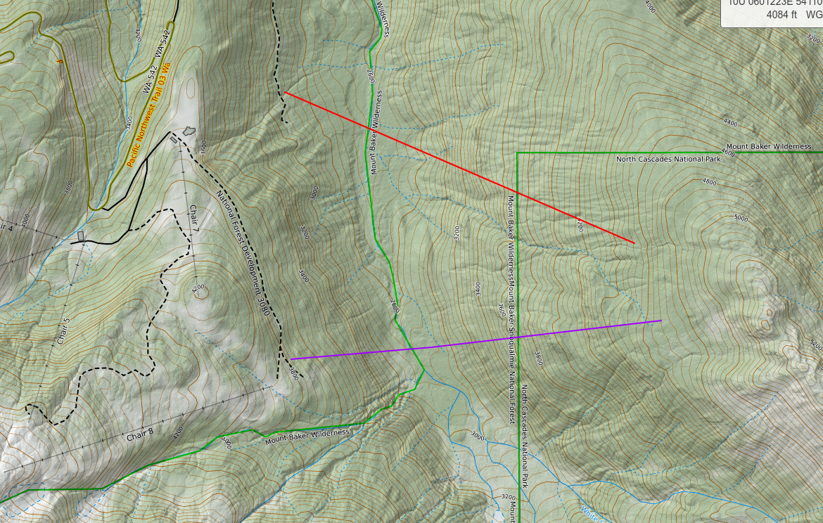
Hi folks, I've done a good amount of digging into the recommended summer route to the base of the north face of Shuksan. It seems like most people recommend descending into White Salmon creek in big timber where possible, crossing the creek, then sticking in big timber on the other side and climb up the slope N of the creek until it opens up. The upper part is near and above treeline terrain that looks like easy travel. I'm curious what folks recommend as the starting point. I'm deciding between the lower but farther downstream White Salmon logging road (red) or the higher but more upstream cat track road to the clearcut below chair 8 (purple). I'm familiar with the winter route and would like to minimize pain of approach if I head up there soon. Thanks for any advice you can offer. Happy schwacking
-
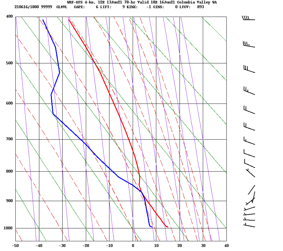
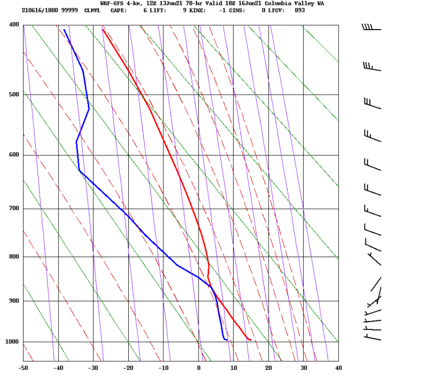
The timeheights seem easier to use, but you can also get an estimate of where the cloud deck will be from the soundings. For example, with the following forecast for Wednesday: Because the blue & red lines touch around 860 mbar, that tells you that there will be a cloud layer there. I forget exactly what the lines represent.. I think one is temperature by height and the other is some kind of "ideal" temperature by height curve. Ok, I looked it up and it has to do with dewpoints. Read this if you care to know more: https://www.weatherwatch.net.au/weather/atmospheric-soundings-an-introduction/
-

[TR] Anderson - Eel Glacier 05/30/2021
Kameron replied to KaskadskyjKozak's topic in Olympic Peninsula
Looks like an awesome trip! There was still a lot of snow eh. More than when I was in there significantly earlier season a few years back for skiing. Really suprising that 3 groups were up there together. -
Later in the season when the snow melts the scramble gets a lot longer, nearly a full 30 m. I need to get up there and camp on that ridge again, when it isn't raining!
-
Well I've skied with Ingmar and he's certainly a crusher/sandbagger. Don't go with him if you want to feel "in your prime" ;-) Rope scramble shenanigans look ok. Nice and short. Anybody got an old static line for me to hike in there and replace the deteriorating fixed line with? From your photo of the lower glacier, conditions actually look good for the direct approach up the valley, gaining the ridge higher up. Nice one!
-
Definitely lucky, although it seems the decision to bail was the correct one. Thanks for the share
-
Current pictures I've seen show really bad conditions on the upper part of Rainier. Maybe it's "skiable", but I doubt it's very fun skiing. Maybe better to plan a walk-up.
-
[TR] Ruby Mountain (7408') - Northwest Ridge 05/15/2021
Kameron replied to Kuato's topic in North Cascades
Cool! If you have any pics towards Primus/Klawatti zone, I'd love to see those. -
At the moment, 410 is closed at the Crystal mountain road. Once the road is driveable, the bike approach becomes worthwhile. https://wsdot.wa.gov/travel/highways-bridges/passes/chinook-and-cayuse/home
-
Yes, definitely ensure a good multi-day weather window for that one. Bike approach from hwy 410 (once it's open) to White River is a great way to do it. You will have that side of the mountain to yourselves.
-
That shit is steep! Nice
-
[TR] Mt. Index - Lake Serene photo trip 03/23/2021
Kameron replied to oldster's topic in Alpine Lakes
Awesome, Jim! Would be cool to see drone shots of the "extreme snowboard" route on the NE face somewhere put up a few years ago. -
Lots of powder snow.
-
I read just a portion of the FS documents (which are many, many pages) and commented that I'm not necessarily against it, but would appreciate the road access being maintained throughout the process. So I let them know that and told them what months I most enjoy being up there. Also, I'm not sure what "selective harvesting" means. I haven't seen much logging around here that isn't full on clear cuts.
-
Copying from Facebook TAY group, posted by Andrew McDavid: "The MB-Snoqualmie NF just posted an update to a logging project along 542 that seems like it will impact access to Heliotrope ridge. I wasn't able to get a clear idea about road/trail closures from the draft impact statement, but they will be logging around the Heliotrope trailhead right up to the Wilderness boundary. Comments on it are accepted until April 3." Here's the main project page: www.fs.usda.gov/project/?project=58218 Here's the pdf about recreation impacts (note highlighting on Heliotrope ridge): www.fs.usda.gov/nfs/11558/www/nepa/113769_FSPLT3_5599267.pdf Here's the link for comments: cara.ecosystem-management.org/Public//Co...bIscf877t14dI0sIy8v4 Please let the FS know your concerns. They should be hearing from backcountry skiers, hikers, and climbers. What the North Cascades Conservation Council thinks: http://www.northcascades.org/wordpress/north-fork-nooksack-threatened
-
Sounds like you are maybe wishing you'd gone on a ski-carrying schwack instead ;-) Looks lovely
-
best of cc.com [TR] Pakistan - K6 Central 10/09/2020
Kameron replied to JeffreyW's topic in The rest of the US and International.
No it's not okay. Maybe for someone else though :-) -
best of cc.com [TR] Pakistan - K6 Central 10/09/2020
Kameron replied to JeffreyW's topic in The rest of the US and International.
Wow this is incredible! Dare I say your line to K6 west looks potentially skiable? Although I don't think so at 70 degrees. -
[TR] Little Tahoma - Lawless 03/03/2020
Kameron replied to Ryan Dougherty's topic in Mount Rainier NP
Wow, wild to go anywhere non-standard on that crumbling choss-pile. Please post pics! -
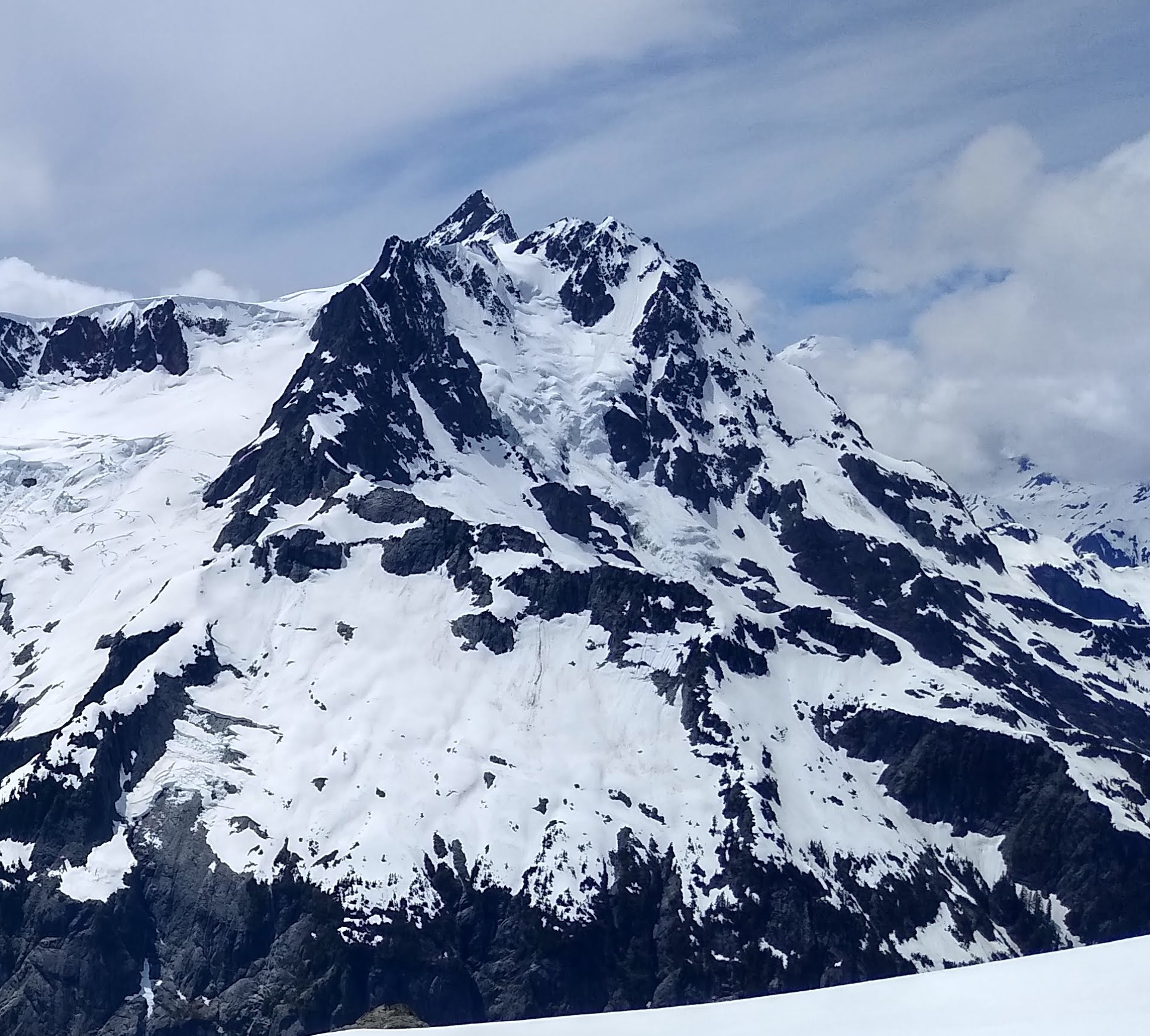
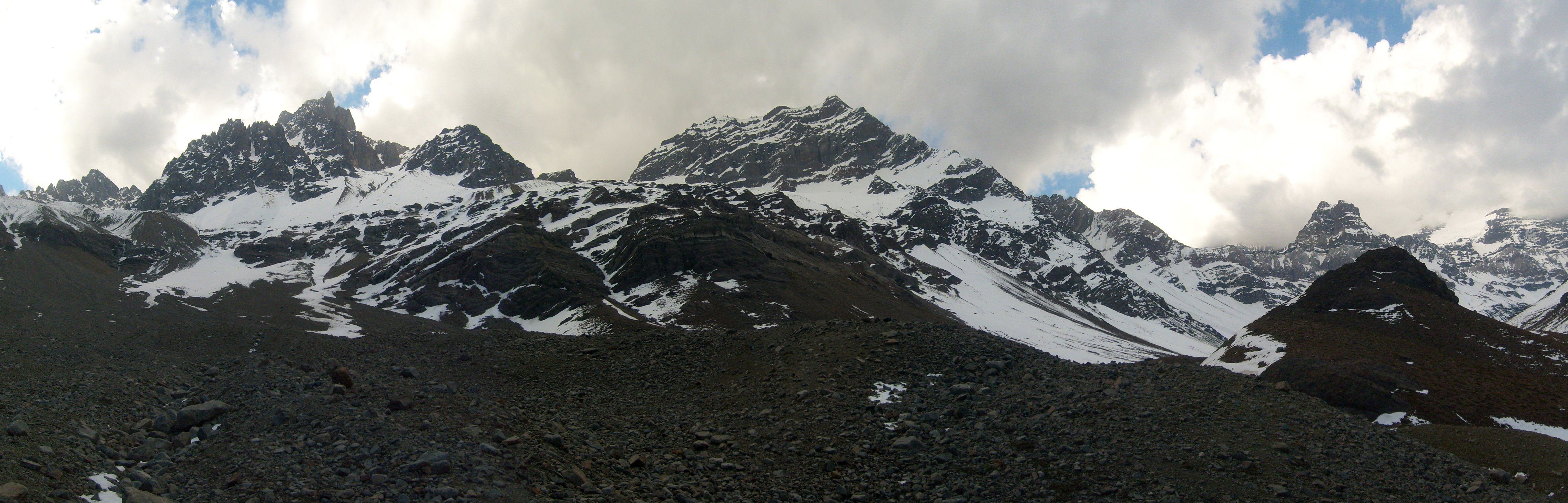
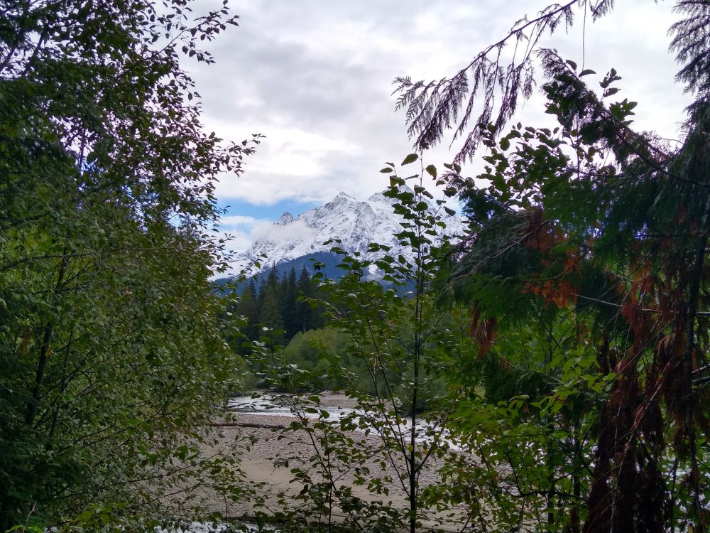
Went for a hike to Hannegan peak Sunday. Not a lot of new snow up there, so there are a number of rockbands. This is from the morning, and much of that white was gone in the afternoon.
-
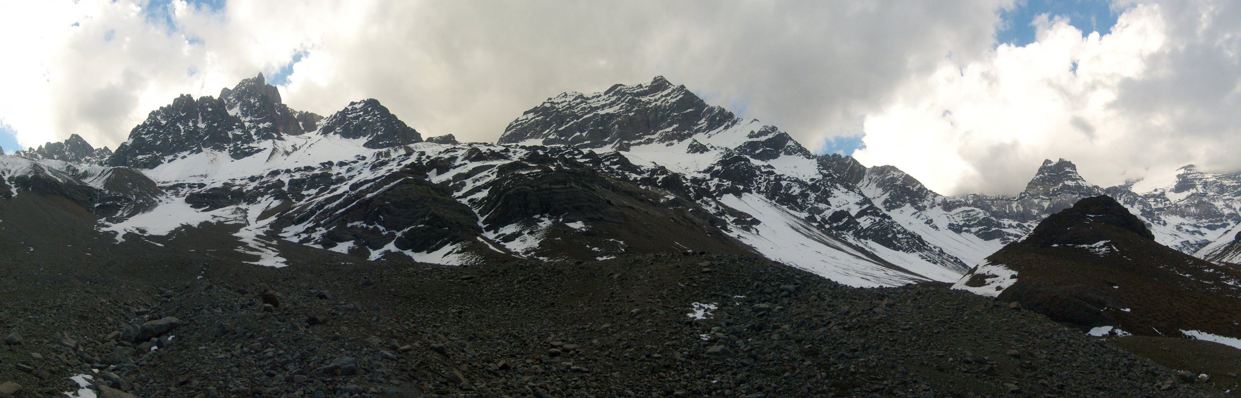
S6302701.AVI video from the summit Ojos de Agua panorama