

mkporwit
-
Posts
814 -
Joined
-
Last visited
Content Type
Profiles
Forums
Events
Posts posted by mkporwit
-
-
skip the tunes, minx... just listen to AM talk radio

-
Nicely done. Wish I could have come along on that one. Instead all I got was an aborted attempt at Thompson...
-
 Ha ha ! He got 9000 but had to chalk up for it! Wow, looking at your registration date Kev (and being math challenged), is that a post every 16 min.!
 Actually, I think it's a post every ~3.5 hours approximately:
bohun[~]% bc
bc 1.06
Copyright 1991-1994, 1997, 1998, 2000 Free Software Foundation, Inc.
This is free software with ABSOLUTELY NO WARRANTY.
For details type `warranty'.
365*24*60
525600
525600 * 3.5
1839600.0
1839600.0/9006.0
204
-
Trip: Mt. Thompson (Thomson) - West Ridge
Date: 7/13/2008
Trip Report:
A few of us decided to make a one-day attempt at the West Ridge of Thompson. The peak had eluded me last year when a friend and I got to the base of the climb and then decided we didn't feel like climbing after all, so I was psyched to go back and try again.
We left the trailhead via the PCT at 5:05am and made very good time. We were at the Kendall Katwalk by 7. The trail was largely snow-free, and what little was there was pretty soft and melting fast. After the Katwalk the problems began. There is still a lot of snow on the trail. Steep, hard sections with unpleasant runouts abound. After stopping at Ridge Lake to filter some water, we made it to the top of Bumblebee pass at 10am. Our initial schedule had called for us to be at the base of the climb by this time. The basin below Thompson is still largely full of snow, and the descent from Bumblebee Pass looked very steep. Parts of the final talus approach were melted out. We figured it would take us another 1.5 or 2 hours to get to the base of the route, by which point this would start to smell like a mini epic in the making, so we called the climb and headed back.
On the way back we took the Commonwealth Basin trail. About 200 yards after the fork with the PCT we promptly lost it in the snow and did not regain it until the part where the alternate approach for Guye heads off across the creek. The rest of the trail was relatively easy to follow, largely snow free.
Gear Notes:
We brought ice axes and made heavy use of them. We should have brought crampons for all that firm snow. The rack did not even leave the pack this time.
Approach Notes:
Lots of snow beyond the Kendall Katwalk.
-
I've had friends head up to the summit of Pilchuk precisely for this, and they've said it was good.
-
Bill, so any advice on procuring one of these mythical hammers? Should I just be watching eBay like a hawk, or are there alternate/better sources?
-
the Strom Thurman school of cosmology
Is that closer to string theory or quantum mechanics?
-
As for the implications for Polish security with the ABMs being stationed there... I would say that enough people hopefully remember Versailles, 1939 and Yalta to realize that the western powers will time and time again sell Poland down the river... those missiles will contribute somewhere between jack and shit...
-
new threat? oh, please- give me a brake! just in the past century poland was invaded 3 times by soviets. 1919, 1939 and 1944/45. we had over 500k soviet troops stationed for almost 50 years! now you tell me who is a threat! we are always a target, so were the baltic countries. i see a strategic alliance with the us as an only possible way to avoid being invaded in the future.
Not to mention that large parts of Poland were under continuous Russian/Soviet occupation for nearly 200 years. The Poles haven't been a threat to Russia since (I think) 1608, when we claimed the dubious honor of being the only european nation to capture and hold Moscow...
-
Trip: Mt. Daniel - Lynch Glacier
Date: 6/28/2008
Trip Report:
A few of us climbed Mt. Daniel via Lynch glacier June 28-29. We went up via Hyas Lake and down past Peggy's Pond.
We started off with a bushwhack. 4 miles in, having crossed the Cle Elum river, we rapidly lost the trail. Rumor has it there is flagging tape in those trees somewhere, but we never found any. We were aiming for the PCT at 4000', but instead climbed up into a cliff band and had to traverse north. Slide alder, devil's club and fir trees abound. From the Cle Elum river the section of the PCT is actually pretty easy to locate -- it is just above a confluence of two streams on the SE face of the ridge.
After 10' on the PCT we climbed up the right of those two streams. There was a good snow lid over it, which made for fast going up. Traversed left at ~4400', picked up another ridge and took that all the way up to the gap just below Pea Soup Lake. Camped by a stand of trees just east of the gap at ~5900'.
Sunday morning we headed up to Pea Soup Lake. It is frozen and easily crossable. Must be at least a foot of snow over the ice, and very few puddles of meltwater on it. The Lynch glacier is also in good shape -- saw a couple of minor crevasses at ~6500' and that is it. The bergschrund at the top is starting to yawn wide where it pulls away from the summit block, but there is a great snow ramp to the saddle. A couple of hundred feet of easy scrambling got us to the summit and some fantastic views.
The descent started off easy, with part of the trail melted out. Then came a traverse on steep, hard snow over the face plunging down to Circle lake. It did not see much sun and was very firm. Some plunge stepping and glissading brought us down to Peggy's Pond. It is still mostly frozen over and there is lots of snow everywhere. Ran into a couple of telemarkers looking for turns on the south faces above us.
The traverse around Cathedral Peak over the steep snow field dropping down to Deep Lake was spicy at times. We gained the ridge and followed the skin tracks down, eventually loosing them and cliffing out above Squaw Lake. Another traverse and bushwhack brought us back on route. There are a couple of camping sites melted out at the lake. The trail from Squaw Lake is mostly snow-covered and we lost it repeatedly, having another bushwhacking session between 4600' and 4200'. We finally found the switchbacks and headed down to the cars, looking forward to beers and burgers at the Old #3.
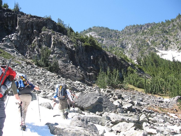
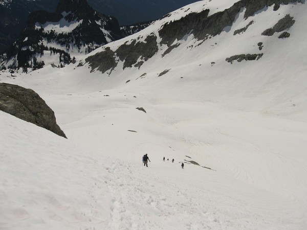
Scrambling up to the PCT -- out of the brush, into the cliffs:
Pea Soup Lake at dawn
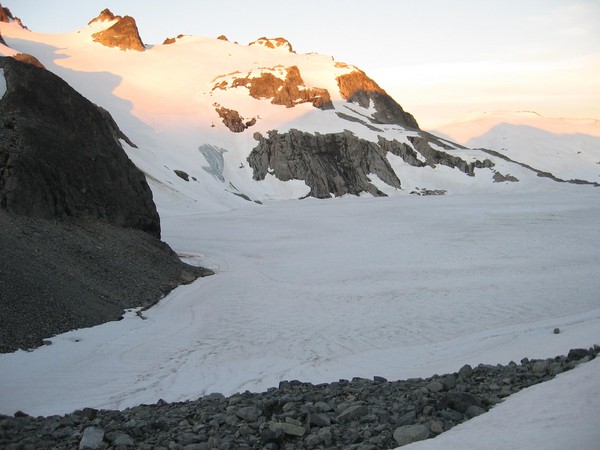
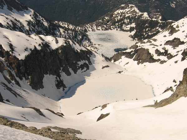
Looking down at Pea Soup Lake, with Glacier peak in the background:
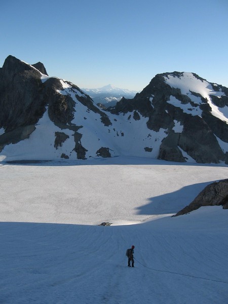
Traversing above Circle and Venus Lakes on the descent:
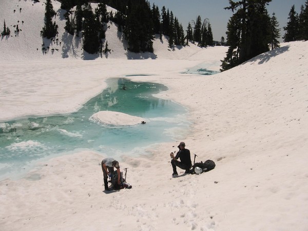
Descending to Peggy's Pond:
Peggy's Pond is still mostly frozen:
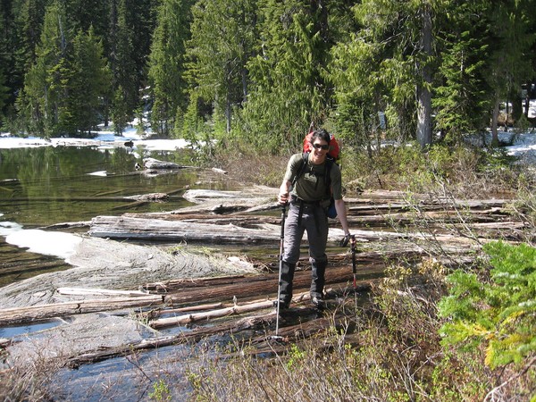
Gian crossing the logjam at Squaw Lake:
All photos courtesy of Darrel Robertson
Gear Notes:
The usual glacier acoutrements. Also of interest, turns out AT&T has a strong signal at the summit of Mt. Daniel. Kinda surprised me...
Approach Notes:
Fish Creek road is snow-free to the trail head. It was regraded on June 28. Scatter Creek was easily fordable in my 4x4 at 10am on Saturday and 7pm on Sunday.
-
So I don't get it... did she call him back or not?
-
BLOCKED BY WEBSENSE!
WARNING! YOU HAVE ATTEMPTED TO ACCESS A RESTRICTED SITE.
CONTINUED ATTEMPTS TO ACCESS THIS SITE WILL RESULT IN A NOTICE BEING SENT TO YOUR SUPERVISOR.

Oh man... do you guys block youtube at work as well?
Sobo, sprobuj z domu...
-
The best part of the comments from gunks.com:
"And as of yet, there's still no thread on rc.com about any of this. What's taking them so long!!!??? How could they miss such an obvious opportunity for gumbys advising gumbys???"
-
that's pretty funny. i'm gonna have to try that in the mall here.
btw, she was pretty hawt. I can't repeat that part...

Of course, if you try it make sure it doesn't end up like this
That's pretty funny too, though for quite another reason. Also significantly less hotness.
-
There are a myriad articles and blogs about various shady camera shops in NYC. Just punch in the name of the shop you're considering into your favorite search engine and chances are you'll find some info.
Also, if their prices are significantly better than Amazon, Adorama or B&H then it is most likely a scam.
-
I'd be interested in knowing about Fish Lake Road #4330... Is it open past Fortune Creek? How deep is Scatter Creek ford right now?
-
Trip: Little Tahoma - East Shoulder
Date: 6/22/2008
Trip Report:
A group of us climbed Little Tahoma this past weekend. We hiked up to Meaney crest and found it to be largely melted out by now. The walled tent sites are dry now. The evening was very windy, and those were the conditions we woke up to at 12. We decided to check again in two hours.
By 2:30 the wind had died down, and the summits of Rainier and Little Tahoma would occasionally be visible through the drifting clouds. We left camp late, at 4am. The snow was good and took crampons well. There were a few crevasses open on the Fryingpan glacier.
The good snow conditions persisted on the Whitman. There are a couple of large crevasses open on it. The rock band marking the exit from the Whitman was iced over in spots, which made it a bit of a pain to get over. The little snowfield above that is melting out fast. The final gully to the crest is in good shape. We tagged the summit a little before 11 and headed down.
Since we had a couple of new climbers with us we rappelled the icy rock band to descend to the Whitman glacier again. There's a couple of slings left up there as a result of that. The snow had softened up considerably. The entire time we were above the marine layer and had pretty good sun, so we plungestepped down the upper 1/4 of the Whitman and glissaded the rest. Unfortunately the Fryingpan glacier was very soft on the way back to camp. We got in another 1500' of glissading down from Meaney crest to Fryingpan creek.
Gear Notes:
Standard glacier gear, some anchor material for rap.
Approach Notes:
The bridge over Fryingpan creek is damaged, but if it held me with a full pack it should hold anyone else. Just cross one at a time.
We were surprised to see that AT&T has full strength coverage on Meaney crest...
-
reposted as a proper TR
-
I'm there to watch the lesbians make out...
-
What's next for him after PM? Ceasar?
There appears to be some uncertainty whether the Russian term limits law applies to total term limits or consecutive term limits. It may be possible that after pulling Medvedev's puppet strings these next couple of years Putin will decide to run for President again...
-
Speaking of Putin, is that guy still the PM? Hasn't he been there, for like, ever? I thought he was out, or does that not happen yet?
He was president for two terms, now he's the PM and his hand-picked stooge successor is now president.
-
-
Beautiful pics, great eye
-
In the self-rescue courses that I've been in, it has been perfectly acceptable to use spectra cord for a prusik or kleimheist on a rope as long as the hitch does not move relative to the rope. So something like a spectra cord kleimheist on an ETO would be just fine.
If you're keeping the hitch open and letting the rope run through it, like you might do with a tandem prusik belay or an autoblock, then the rope slipping past the same parts of the hitch can lead to damage of the spectra and should be avoided.
road trip tunes
in Spray
Posted
Minx, I think that's all they have in the middle of nowhere... think about it... you, the open road, the faint crackle of static on the am, some looney telling you to come to Jesus in spanish... it will be a life-changing experience. I'm sure of it.