


gomek
-
Posts
24 -
Joined
-
Last visited
Content Type
Profiles
Forums
Events
Everything posted by gomek
-
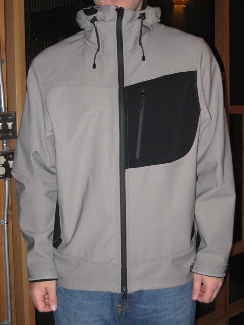
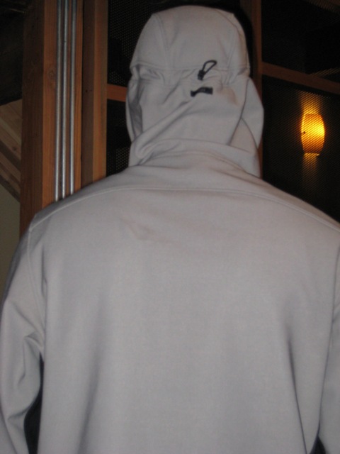
Nice soft shell, couple years old but rarely used and in great shape. These are $190 new, looking for $60? Jason Jasonconnell@gmail.com I'm in Seattle (Wallingford).
-
This thing is a beast. I bought it back in 1998 for a trip to Aconcagua. It was more than enough coat for that mountain and kept me toasty on Denali a couple years ago. Shows a little bit of wear but this coat has 20 years left in it. As I recall it's 800 fill goose down with a Gore Dryloft shell. here's a bit of info... Size XL (I'm 6'2" 200lbs and I can layer under it). Gore-tex DryLoft® DryLoft Fabric - from WI Gore is a windproof, water-resistant and extremely breathable fabric technology engineered specifically for insulated products. DryLoft fabric allows garments to loft better and stay drier inside while resisting moisture and convective heat loss from the outside. Looking for $175 or offer. Jason 206 696-2726 jasonconnell@gmail.com I'm in Seattle (Wallingford).


-
Do I hear $150? If so PM me...
-
Has anyone been up the road this week? I heard a couple weeks ago that it is still blocked at MP17?
-
Give the rangers a call. Cold springs is usually not clear until the end of June.
-
Don't knock purple, this is my climbing suit.
-
http://www.sierratradingpost.com/xq/asp/base_no.72197/dept_id./est./qx/product.htm
-
Shoot me a pm.
-
Drink a bunch of water and suck it up.
-
Looking for a little Beta, I plan on going in from the Muir Snowfield. Thanks! Jason
-
Link to a few pics. http://www.jasonconnell.com/modules.php?...=view_album.php
-
A few friends and I took off from the Narada Falls parking lot Saturday morning at 9:40am. The Rangers opened the gate at 9:00am sharp. We took the trail up to the Steven's canyon road and followed the road until it veered off towards Reflections Lake. After leaving the road we took the path of least resistance as we descended 300' in the direction of Lane. After an easy stream crossing we were at the base of the North Face. The plan was to climb the Fly since we had heard it was the closest to being in shape. When we reached the base of the Zipper it proved to alluring for Shane and Stuart and we agreed that we would meet them back at the trailhead. Rod, John, and I continued around to the Fly. This was John's first climb and we thought the Fly would be plenty sporty. The first 2/3rds of the route were mild due to 2-4 feet of powder. At 2/3rds height (with snowshoes still on) the chute narrowed to less than 8 feet and the angle went up to 50 degrees or so. The snow was thin at this point and we had loose rock and a bit of ice underneath. There was no chance of a picket holding a fall and a useless belay didn't seem worth roping up for. John managed to work his way up over the rock with much effort. While this was going on Rod slipped about 5 feet and slid into me. Deciding to take off his snowshoes Rod moved up and to the left. A minute later John (who was out of my sight) came sliding over the rock and also slid into me! He slid about 30 feet but was no worse for it. After untangling ourselves we ditched the snowshoes and dawned crampons. From that point getting to the top of the Fly was uneventful. From the notch below the West ridge we down climbed a couple hundred feet on snow and began traversing east. Referring to a picture I had of the South side of the mountain we passed the standard gulley to the summit and continued towards the Col between Denman and Lane. We could now see the way out so a quick debate on weather or not to go for the summit ensued. It was nearly 4pm but the weather looked good so we figured getting out after dark wouldn't be too bad. Instead of back tracking to the gulley we saw we headed up on the far SE side and scrambled up. Class 4 for a good part of it on sometimes wet or snow covered rock was plenty sporty for me. We were just a few minutes into the descent when the sunset. John got his first NW summit and earned every bit of it! On our way back to the Col we ran into Shane and Stuart, they had just topped out on the Zipper. The 5 of us hiked out in perfect calm conditions and got back to the parking lot around 6:45pm. Footnote: Go get either one of these routes while the path we beat is still there! Lovers Lane looked like it still needed a lot of snow. If you go up the Zipper be on the look out for a MRS Snowshoe that Shane lost down the crux of the route. If you pick it up PM me :-) Pictures to follow... -Jason
-
I picked up a few pairs at the OR sale too. Pretty lame selling them for twice the $22.50 you paid.
-
Saturday the sanding truck didn't roll up until 8:00am and the gate opened at 9:00am. The Ranger gave me a bit of grief because I didn't have chains for my Expedition and it was now required to at least carry them in 4x4's when conditions warranted. I also found out that the gate is really closed at 6:00pm. We had a longer than expected day on Lane and had to get the Combo from a very nice lady working the counter at the lodge.
-
Let's see proof! I am guessing it went for $225 Clown!
-
Thanks Guys, Congrats on making it to the Football Field Flatlander! We had some friends that didn't make it up to high camp earlier this season. Coming straight down from 17,000 wasn't to bad but the feet were in agony the last few miles.
-
Team "Danger Duck" was in full affect on Denali from 5/22 - 6/7. Team Danger Duck was myself, Rod, Lonny, and Gary. Pic link Denali Pics 5/20 - Flew from Seattle to Anchorage arriving a little after midnight. Got picked up by Denali Overland and were whisked away to Talkeetna. 5/21 4:00 AM - Dropped off at the Talkeetna Air Taxi bunkhouse in town. We ended up dropping our gear and walking the mean streets of Talkeetna for a few hours until the Roadhouse let us in to feed our faces. After eating we headed straight to the airport just to be told that all flights were on hold due to the weather. Enter stage left - The West Rib Pub and its wonderful Ice Axe Ale. Sure they say you can only have 2 but 2 at lunch in the restaurant and 2 an hour later in the bar and I was feeling no pain. Add a few more Alaskan Ambers to the tab and me and my "Roadie" bottle of Sierra Pale were staggering back to the Airport to crash. 5/22 8:00 AM - I'm not going to lie to you, I was hurting. After eating breakfast "twice" Rod and I spent most the morning hanging out at the Ranger Station people watching and reading old Alpinist issues. The Rangers had us convinced we would be stuck in Talkeetna for several days due to the weather. Around 1:00 PM we headed back over to TAT to meet Gary and Lonny. After hanging out for a few minutes the call came that flights would be leaving ASAP. After a lot of starting and stopping and a short 6 hour wait we were on our way to Base camp. After an uneventful flight and landing we found ourselves on the glacier sorting gear and packing our sleds. After just a few minutes a huge avalanche broke loose up the glacier from us off the flanks of Mt Hunter. A short time after this I hear someone calling my name (actually by a nick name), it is another buddy I knew would be at base camp who was going to attempt Hunter. They had been surveying the Lowe-Kennedy route and had nearly been buried in the avalanche. Welcome to the Alaska range I thought to my self. After saying our goodbye's we headed off into the "night" bound for 7,800 camp. 5/23 - We got a late start and single carried up to 9,000'. No one felt like pushing it so we set up camp. 5/24 - Best weather day on the trip by far, hot and not a cloud in the sky. Carried to 11,000. 5/25 - Moved to 11,000. 5/26 - 5/31 was miserable for the most part. It never really stormed but the weather was crap. It never seemed to stop snowing. After a few crappy days at 11,000' made a carry in bad weather to 14k. The top of motorcycle hill was actually worse than Windy Corner. After a rest day we moved up to 14K, on 5/29 I think. 6/1 - Carried up to 17,200'. When we left camp it was snowing but we wanted to get moving. About the time we got on the fixed lines the weather started to clear. The ridge walk up to camp we were treated to spectacular views and no wind. We cached right outside of high camp, even at 8:00 PM it was warm. We all knew a bunch of people must have made the summit. We headed down getting back to camp at midnight. 6/2 - Rest 6/3 - Move to 17,200 camp. This was a long haul and it was cold and windy as we approached camp. 6/4 - Rest, retrieve cache. 6/5 - A lot of people were up early so we started getting ready. While we were getting geared up Rod got his hands cold to the point we could not rewarm them and he was forced to stay behind. We left camp and were shortly stuck in a high altitude traffic jam on Denali Pass. Above Denali Pass the wind remained reasonable and we continued. Once we reached the Football field I was bumbed to see we had to decend a 100' and even more bumbed to see Pig hill still facing us. The flip side of course was we could see the summit! After an eturnity and another traffic jam on the summit ridge we were on top with a bunch of lame ass french guys on SAT phones and an even more lame group of USC Frat boys who actually refused to take our picture because they were "to busy" getting their summit shots. After snapping a few shots of our own we headed down, arriving in camp at 9:00 PM, an 11 hour day. 6/6 - 6/7 - We packed up and left high camp at 1:00 PM. We decided to push straight through to base camp and a short 13.5 hours later we were there! The hike down from 7,800' to Base really was wonderful. We left 7,800 at 11:00PM and were all alone on the glacier. We were so hopeful that the weather would be good enough for flying that we didn't even set our tents up. After getting aced out of our first position by a very crafty Alpine Ascents guide/group we flew out a bit before noon. After landing we shot over to the West Rib (After checking out and dropping off our CMC's with the rangers) for more Ice Axe Ale and A LOT of food. We caught the 3:30 PM Shuttle to Anchorage and the 7:30 PM flight home to Seattle. The End...
-
Wow, sounds like a great deal! Or I could buy a brand new one at REI for $251 http://www.rei.com/outlet/product/47842664.htm?vcat=OUTLET_SSHP_CAMPING_HIKING_SA
-
I was on the team going up the Kautz that morning. We got a late start and were really surprised to see you guys coming down before dawn. We had no idea about the ice fall and just figured you guys were super fast. Glad to hear you guys are ok, that must have been a frightening two minutes. Our group turned around at the ice cliff due to the same white out conditions the other group ran into. -Jason
-
There is some snow at the trailhead but it is patchy from there to Pebble Creek. Bring snowshoes or crampons, there was a little bit of ice this weekend on the snowfield. Road to Paradise was clear (this can change quickly). The gate at Longmire may not be open until 9am, call ahead to find out. GPS - Wands - map and compass - bring one bring all if the weather looks bad.
-

[TR] South Early Winter Spire- Southwest Couloir 4/24/2004
gomek replied to gomek's topic in North Cascades
Thanks Alex! This was my climbing partners first Alpine Summit. -
Climb: South Early Winter Spire-Southwest Couloir Date of Climb: 4/24/2004 Trip Report: Please be kind this is my first post / TR. My friend Shane and I left Seattle Friday night around 8pm planning a ski / climb of Silver Star. We found a nice spot at mile marker 167 where we were able car camp. The route we had planned was Silver Creek but the route description we had was for Burgandy Col. The route from mile post 166 had very little snow so we tried to come up with an alternative. We headed over to the Blue Lake TH and decided to try the SW Couloir on S Early. It was right at freezing when we started skinning up. About an centimeter or two of snow had fallen the night before. We were able to Skin up to a tree at the base of the climb. We had some lunch, roped up, and started up. While we were eating a fellow named robert stopped by. He decided to head up with us. After a couple hundred feet I decided to set a picket. At this point Robert decided to head back down. The snow was still quite hard in some places and no steps had been kicked in. We ran a few belays before reaching the top of the couloir. We unroped for the rock scramble to the top. -Jason Pictures and more info http://www.jasonconnell.com/modules.php?set_albumName=album72&op=modload&name=Gallery&file=index&include=view_album.php Gear Notes: Had: 30 meter rope, 2 pickets and slings. Shoulda had: longer rope for Rapp Approach Notes: Snow down to the parking lot. Was able to Skin up to the base of the route.