


5.12Dreamer
-
Posts
34 -
Joined
-
Last visited
Content Type
Profiles
Forums
Events
Everything posted by 5.12Dreamer
-
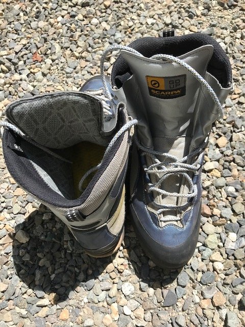
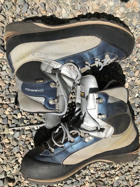
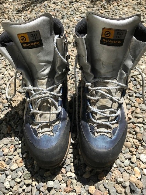
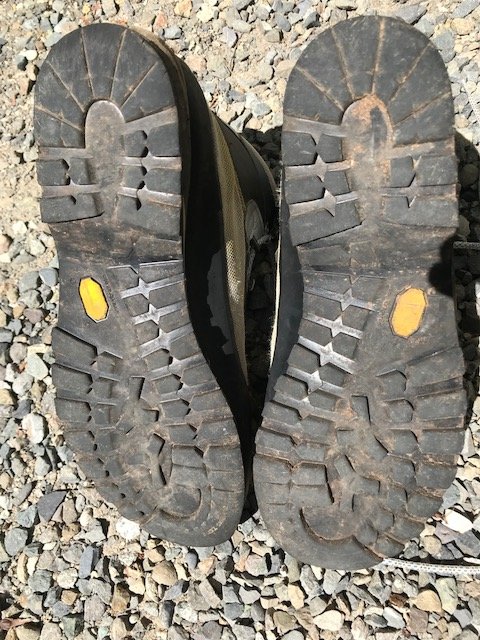
Knocking the price down to something more reasonable! Size 47 / US 13 Scarpa Charmoz mountaineering boots., $50. Used for four seasons, still in good shape overall. Left boot seems to have a small leak. I needed to upsize so I decided not to seal the boot (they are GoreTex). More on the supposed leak: it really didn't affect me on day or single night climbs, I was just apprehensive taking these for a fly-in approach for a multi-day AK trip so I bought new ones, that are a size larger and fit me better. Tom 2o'six-9one0-fourfive88
-
A Ridiculous amount of gear. Mountaineering Stuff
5.12Dreamer replied to JesseToedtman's topic in The Yard Sale
Hey, I'm interested in some of your gear--at a min the Viper ice tools and some of the ice screws but possibly other stuff if still avail. Send me a PM and I'll get back in touch. Thanks! -
This is perhaps not too helpful but something 'til you hear more: I was in the park on New Year's (an infamous day). From the Stevens Canyon Road, at the 90 degree bend to Reflection Lakes, you can see the cliff from a distance. But I'm not sure if you can see The Blue Room from there? I noted from this considerable distance, a fair amount of ice, though nowhere near climable then. To give it a ROM, I would say what I was looking at was half formed then--not even top-ropeable but offering promise if conditions continued in the right direction. Since then it got warmer, then it got quite a bit colder and wetter--so maybe...
-
You can use a rubber wedge under your insoles to take up slop; also, the "cork" inserts called five irons--they are flat insole shaped shims that take up volume, standard boot fitting stuff. REI or a ski shop will probably give you some for free. Also, might be rather obvious but just to cover the bases, there are many thicknesses of insoles and some have a much better heel cup than others so compare them for what will work best for you.
-
Was up there this past weekend attempting the Gerdine Ridge route. On the NF Sauk approach you get into snow several switchbacks short of the PCT. Surprisingly. there are some snow free tent sites at White Pass. In general, travel on the snow was good. Mostly penetrated only a few inches to boot top on rare occasions. The snow cover allows you to take the Beckey approach through the NER of White Mountain, then hold a traverse at 6400' all the way to the White Chuck Glacier. This way you avoid the elevation loss descending into the White Mtn basin or the longer alternate route (easier w/o snow?) from White Pass. Snow free camping at Glacier Gap too. Very windy, however. We were thwarted by low visibility, navigating to the Gap in a total whiteout. Then optimistically climbing to 9000'in the whiteout the following morning. We would have kept climbing except for seeing signs of slab activity on the Disappointment Peak bypass. One of our party heard cracking and we observed a number of discontinuous fracture lines--time to turn it around. Didn't have time or the desire to persevere the high winds to attempt the DP direct route. Best of luck if and when you make it out there.
-
[TR] Shuksan - Suphide/SE Rib Variation 7/1/2009
5.12Dreamer replied to tazz's topic in North Cascades
Nice shots and good climb; especially like the B&W, which is often underused. Hey, how suitable are those seracs on the far RHS of the Sulphide for ice climbing practice? Accessible? Safe? As in did you see things coming down? Large enough? Hard to tell the scale, they could be huge, or only body height... Thanks! -
Nice work! Great weather last weekend, although pretty hot for glacier travel. Hey, did you note what kind of shape the lower glacier is in? Specifically, whether there are exposed seracs rather than still being buried under seasonal snow. I am looking for an ice climbing practice area, as the lower Coleman will be a LONG approach until the road is repaired. Thanks!
-
Recognize this Tumwater Canyon route?
5.12Dreamer replied to 5.12Dreamer's topic in Ice Climbing Forum
Thanks Rat, sounds right although I'm not familiar with the Recurve Dihedral. Searched cc here for that route and turned up nothing. Ice or rock route? Is it up and right? -
Recognize this Tumwater Canyon route?
5.12Dreamer replied to 5.12Dreamer's topic in Ice Climbing Forum
"Seems odd it (how to post an image) wouldn't be a FAQ." Sorry, I checked again and saw the FAQ item in plain sight. But that method didn't work as you see above. I noted that my draft post said HTML was disabled but I couldn't find where to enable it. Also not sure how to control the image size that a site like Picassa or Flickr will use--the original? If so, I'll have to make a new folder with reasonable size images. -
On Sat 2/21 a friend and I did a two pitch WI2+ climb that lies on the other side of the Wenatchee River about 1/2 mile S of the Swift Water area. It is roughly 1/4 mile S of the pullout just S of Swift Water. Curiously, I haven't come across any info on this climb. Nor does it look like anyone has been there recently, as we didn't see any rap slings. But it's a quite a fun climb, and pretty easily accessed once across the river. We crossed to and from the big sandbar just N of the pullout, which made it pretty straightforward in our canoe. There is flagging on either side of the river just N of the sandbar, which we guessed might be there to signal the beginning of the sandbar in higher water rather than indicating a good crossing (there is not much of a shoulder on the hwy there and the bank is very steep and brushy; plus, there are small rapids). In most (all?) seasons I imagine this tight drainage is buried in snow, and the avy danger would be off the chart. Matter of fact, all the snow that fell early this season extends down the drainage to the river now. Given that the climb is well protected from the sun, it ought to be in shape for a while yet. From the highway we thought it might be 3P up to WI4, but we found that there is low angle ground covered in the upper pitch and that there isn't anything above it except for more low angle snow covered terrain. Anyway, it's quite a bit of fun if you're up to crossing the river! I know I saw a topic on this site for posting pictures but I can't find it now. Seems odd it wouldn't be a FAQ. I'll try to put a couple shots in here but I don't know what I'm doing when it comes to web pages.
-
Thanks for the clarifications and the extra info; I agree with your statements on comparing (not) the Nepal to the Extremes. And I definitely agree with the extra leverage a larger boot exerts on its shank. I've been amazed to watch people climb ice in small boots that I could never use in a Size 13.
-
Dane has given some very good and thorough info so I'll just add my personal experience with the Extreme and Nepal boots. I bought the Extreme last year to replace the prior design (yellow) that was 1/2 size too tight. Climbing one season on each of those I felt that the Extreme was perhaps not quite as stiff and that the "lightweight" construction was not worth the loss of durability. At the time I bought the Extremes I noted in the LS catalog that the boot was supposedly at most a couple g's lighter than it's predecessor--not at all worth the sacrifices IMHO. I will acknowledge they are nice for approaches and rock, but so were the prior design. Now, for steep ice I find the Extremes too flexy when coupled with a "semi-rigid" crampon. I don't agree with Dane that the Nepal and Extreme are close in stiffness for a large boot (Size 47). The Nepals seem far superior to me on steep ice, and their lacing system is also far superior to the Extreme. You can really get your heels locked down in the Nepal and the removable tongue insert saves your shins from the agonizing pain the Extremes can impart when really cranked down. If one is going to use the boot for long approaches to alpine rock and moderate ice, I'd probably stick with the Extreme or look at the Prime (not familiar). For pure vertical performance I find the Nepal blows away the Extreme and with snow covered approaches they seem fine. This season I parlayed my Extremes to buy the Nepals and I have been very pleased.
-
Boeing Alpine Assoc (BoeAlps) is holding a club outing in Lillooet this weekend (1/30-2/1). We'll be in the typical spots (Rambles, Marble, etc.) and we'll try to minimize impact and be good neighbors. And perhaps most importantly, leave some ice on the routes for the rest of you to climb!
-
I'm interested in the leashes, if you're near Seattle or can ship them.
-
-
Bug--do you say Rat Creek for the N and W faces? For the SF, having gone in via the Eightmile Road and the Snow Creek Trail, I would choose Hook creek. Spotly--three hours of hard work is nothing compared to either of those approaches! Four of us went in via Toketie Lake (Selected Climbs approach) a few weeks ago. It was apparent to me that the guidebook description of a camp and a climbers trail precedes the huge November windstorm a couple years ago. That storm knocked over a lot of burned trees left standing from the fires, covering much of the "trail." I believe the camp area is gone too, as we didn't see it going in or coming out. The entire area off the Snow Creek Trail there is filled with downed trees. To approach via Snow Creek is very arduous--five miles off trail travel gaining 4000', a lot of it over boulders and trees. But you can follow sections of the trail on the climber's far RHS of the talus slope, which saves a good deal of energy. I would go that way if you're interested in spending time at Toketie Lake, which has lots of great looking rock. For the Rat Creek Group, Hook or Rat Creek now seems the best to me. Some beta on the Snow Creek approach--there is a TR that added to the Selected Climbs Snow Creek approach description, something along the lines of "When the trail leaves the creek for the last time ..." It might be more clear to say that at about 3.1 miles and 3200' you will first experience the trail leaving the creek and ascending through some switchbacks. Keep going past where the trail crosses a newly reworked streambed, which is lined with granite rocks. Shortly past this is where you should look to leave the trail and cross the creek to the boulder field on the other side. You'll need to climb up through the boulders a couple hundred feet or so before you can pick up the trail on the far RHS. You can travel some long sections of the trail, leaving it for the rock when blowdown covers it. As for the Eightmile road, three of us attempted to approach The Mole that way in July 2000--I cannot recommend it as you lose a lot of elevation descending to Rat Creek then have to wrangle through tons of alder to cross the creek. We never fully made it to the other side with enough time to do the climb and pull back out the same day. This was with an early start from our bivy on the ridge opposite Rat Creek. If you also want to spend time elsewhere in the Enchantments the best idea might be to approach from Shield Lake--that looks like straightforward travel through the more level and open area or the Enchantments.
-
No doubt, Lambone. Sorry about the smart aleck comment, just couldn't resist as I was hoping to see a report on Synchro anyway. Did you look at wading the river? Two weeks ago when we saw the log gone we thought that might be preferrable to the long traverse across the breakable crust. Although I haven't done it, I'm sure I've done far worse so I agree with whomever wrote that the traverse is not a big deal--in normal conditions; with the hard crust and the boulder field it could suck enough to just wade the river, should it not be too deep.
-
Dang, that's what I call fresh beta--it's not even Thursday and you've already climbed it and reported on it!
-
Thanks. Do you think you could have two lines working simultaneously? I've never been up to it; it looks narrow from the highway but I know it's foreshortened from that angle.
-
Awesome; we'll have a look. Thanks G-Spotter. Rafael, after you wade the river to anchor our rope on the other side I'll be happy to Tyrolean across!
-
Boeing Alpine Assoc. is having an ice climbing outing in Lillooet this weekend. Just want to give some warning before you find more people at the Rambles area than you hoped. We'll have about twelve total and we'll do our best to lessen impact to any one particular area, conditions depending. If anyone has input on other good areas for n00bs, by all means, please share. Weeks ago I was also eyeing Honeyman Falls, although with the warm weather over the last couple weeks I don't see how it could be in shape. And, to ease fears: we are not planning on visiting Marble en masse and bringing it all down. Thanks and see you up there, Tom
-
Bruce, Although I was sorry to see the gravel go b/c I was sure more injuries would result, I place a lot of importance on air quality and taking responsibility for your own fall protection. Over the many years I've been using the gym I noticed that I would develop a wicked sinus headache the following morning. That pretty much kept my sessions to one or two a week, at an hour or two at most. If I spent two hours in there, I could count on a terrible headache. A cleaner environment is a good thing for everyone, especially those that work there and hence have more exposure. That said, I implore you to be strict with the no loose chalk rule. We can be almost certain that people will not comply with a rule that is not enforced, especially one that has nebulous outcome when flouted. If SG spent all this money to improve the air, at risk of more injuries, then you have to ensure the return on your investment. Here is some testimony on effectiveness, from several years ago when I visited the gym in Eugene. I climbed there that afternoon and was amazed how "new" and clean the place was. Afterward I was talking to the owner and asked how long it had been open, to which he replied five years! I said I didn't understand how it could be so clean, and he was adamant that it was because they were really strict about no loose chalk. Anyway, I'm looking forward to my next visit, with less dust or not!
-
defunking stinky rock shoes with mirazyme
5.12Dreamer replied to genepires's topic in The Gear Critic
Something that is really effective and easy: get some Dr. Scholl's Sure Shot or Power Shot (can't remember what it's called) and shoot this talc into your shoes before climbing. It comes in this bottle with an angled neck; it is made for this purpose as all you have to do is give it a quick squeeze and it shoots the right amount of powder into the shoe. This stuff will soon totally remove the smell, and when used somewhat regularly, prevent it from coming back. It also makes your shoes more comfortable because it keeps you from sweating so much, which is the cause of the problem. -
Very nice shots BlackHawk! Quite the vantage point for this weekend's activity. I can't wait to check the pics out more carefully b/c we had a group of five on this variation. We found it to be nothing like Organ Donor's post of "It will add a little more to the climb though, roughly an extra hour." From above the Flats you will lose about 600' of gain. (You actually need to descend from a couple hundred feet above the Flats.) The route takes a descending traverse beneath the DC and the icefall bordering it on the lower RHS; this part is straightforward and wanded. One problem is encountered soon after turning up the Emmons: the route crosses over some steep seracs. This appears to be the only way through in the immediate area. One of the guide services put a fixed line here, secured with pickets and srews top and bottom and several screws along it's length. This is a short bit of AI3 and it will cost people w/o steep climbing experience significant time. I belayed my group up and down it and you all know about how long that takes. Sure, you could clip the fixed line, which we also did, but I knew I was going to be above and out of sight and I didn't want to have them clipping past the gear while gripped; it seemed safer and not much slower to belay. Another reason why this variation will cost quite a bit of time is it's very circuitous: it descends, then traverses way over towards the Emmons shoulder, then begins a long rising traverse back towards the top of the DC! Maybe you can tell from the pics whether this is really necessary; it would obviously be best to ascend to the climbers right. Also, reportedly at about 13K there is another wide crevasse bridged by a ladder that people are belaying across. This is a significant bottleneck that we decided to turn back before encountering, largely due to time and party energy. BlackHawk, did you see the Chinook come in? This was mid-afternoon long after we were back at Muir. It flew overhead directly towards the summit, where it was out of view behind Cathedral Rock for some 15-20 min before making a beeline out of there. I can only think somebody took a spill on a ladder or descending through the seracs. One more note on the fixed line through the seracs (by the way there are two but the upper one is really not necessary). On our way down the lower fixed line we found the two lower screws near the hardest moves melted out. I replaced them well; it appeared to me that they were placed in the surface ice rather than deeper into the hard blue glacial ice. They were solid when we passed them going up but they did not last long before melting out. Undoubtedly many parties that climbed the DC came down the variation. When we were at the Flats all parties were climbing up the DC: we were the only ones to do the variation since the very early morning parties. We left Muir at 1:30 and began the variation perhaps at 3:30, after a big crampon snafu and some routefinding challenges. Seemed like the other parties on this route probably were at least a couple hours ahead of us; nobody came after us but because we pulled the plug we were the third party back down it. I was checking out Little T all day, and wondering where the standard route originates: thanks for the great write up!
-
About a week ago I picked up a Mammut synthetic insulated jacket. It has an insulated hood and substantially more fill than the OR. Feathered Friends has both plus a lightweight Moonstone. Last weekend I was in Chicago where it was 0F with a good 20mph wind and I was still toasty. It packs down to a reasonable size and the price was decent for full retail ($179)