


klenke
-
Posts
3661 -
Joined
-
Last visited
-
Days Won
1
Everything posted by klenke
-
Good points, Tod. However, I would like to qualify that the naming of peaks that went on prior to the advent of mountaineering is not really germane to the debate here regarding FA naming rights. Back in the 18th and 19th Centuries, only those commonly seen peaks were named (for point of reference purposes). These were usually the most prominent peaks such as Baker, Rainier, and maybe Mt. Pilchuck. Captain Vancouver and his compatriots certainly didn't care to name this little blip or that little blip on the mountainous horizon (blips such as Big Bear Mountain south of Three Fingers or even Mt. Si). Over the years of the last Century, peak naming has progressed downward to less and less prominent peaks. First it was the real big boys who were given names (Rainier and Baker). Next it was high peaks around mining areas (peaks in the Monte Cristo area, for example). Then, with mountaineering coming vogue in the 30's, noteworthy peaks on the horizon as seen from other peaks by those early climbers were named (can't think of an example). The next wave of naming came with Beckey and all his FAs of peaks all over the place (Snagtooth Ridge peaks, for example). The most recent wave could perhaps be attributable to the likes of the Fireys and John Roper (Genius Peak south of Dumbell, for example). These most recent names are for peaks of even less prominence (Beckey's many crag names notwithstanding). In the next wave of naming (new names, not renaming), what is left? Of course it would have to be ridge blips of even less prominence, for they are all that is left to be named (in the explored areas of the Cascades, at least). There are plenty of unnamed and unclimbed peaks in northern B.C.. The naming revolution has only just begun for these.
-
Ray said, "Whether there is some animosity or difference you two may have is up to you. I dont really care." Well, you must care because you felt the need to stick up for your idol and personal friend in your last post. I am damn thankful to Fred for his CAG guides. Be that as it may, I certainly don't worship the guy. I felt no need to shake his hand when I first came to be in his presence at a Pub Club. If it had not been Beckey who wrote the guidebooks, I'm sure someone else would have. Whether or not that other person would have done a better job is debatable. I would have to say he/she probably wouldn't have been as thorough as Beckey. That notwithstanding, the guidebooks Beckey has put out are not infallible. There are errors in it. These errors need to be fixed. They will be fixed in due time. Since the Cascades are a huge range of many mountains with many approaches and climbing possibilities, I do cut Beckey a fair measure of slack. With all that information to organize, he's bound to have slipped up here and there.
-
Fox: A = Tomyhoi most likely Fury = East Fury. West Fury (Fury's highest point) is to the left of where you have labeled. G = probably something on the ridge between East McMillan Spire and Elephant Butte. There are a couple of bumps in that ridge between those two peaks. G is probably one of those. Spickard = Not Spickard. Spickard is the highest peak in that area, therefore it would appear taller as such. What you've got labeled as Spickard would have to be something between Fury and Luna, which is just out of view to the right. Spickard would be visible too, but farther off the right edge of the image. Looking at my mapbook, the peak you've labeled Spickard may be Red Face Mountain (7,174 ft) or something in the vicinity thereof. H = God knows...but he probably doesn't care either
-
Harry Majors said: "Other first-ascent-party names on Ragged Ridge that had been similarly dismissed include: Mt. Holyoke (Katsuk Peak), Gendarmes Peak (Kimtah Peak), and Ragged End (Cosho Peak). Dr. John Roper and the Fireys were the pioneer climbers on Ragged Ridge. If anyone had a right to name these particular peaks, it was they." I actually agree with a Canuck here!!--sort of. I agree that Holyoke is less inspiring than Katsuk. How many mountains out there are named after some climber's East Coast Ivy League alma mater? This is a conceit that has never really sat well with me. I tend toward, "Screw you and your holyoker than thou East Coast persnickety college!" There is a Mt. Harvard, et al. in at least three western states that I know (including this state). The city of Holyoke is farther away from Ragged Ridge than the Chinook tribe is. So, the argument for proximity is a little less valid in this regard. "Holyoke" no more captures the quiddity of that peak than "Katsuk", probably even less so. So who's naming was uninspired is a matter of perception. All that said, I do still agree that the first ascensionists should be the ones honored with the naming of the peak they've just climbed. If they're trying to name something they haven't climbed that is nearby, then I don't think they should have the naming honor. It is up to the Washington Board to decide whether a peak should be renamed. The argument for renaming would have to be very persuasive, in my opinion. Just because I don't like the name of something, it doesn't mean it should be renamed. I just have to accept it and move on. I'm very conservative in this regard. Political Correctness be gone! Further, I see nothing wrong with naming a peak based on its characteristics--be it evil or heavenly. I'm sure religious zealots would prefer nicer names than Devil's Thumb and Mt. Terror, but I bet most climbers actually prefer names such as these. There is a Heavens Peak in Glacier National Park. There is a He Devil Mountain and a She Devil Mountain in Idaho. To me, these latter two have more compelling names. If I had to make a choice between going to Heavens Peak (actually, it is a nice looking peak in the park, see here) or The He Devil Moutains not knowing what either look like, I'd probably choose the latter. I would like to qualify by saying that I think the word "Devil" is overused for toponyms--overused to the point of being trite. I propose Nefarious Thumb or Pernicious Thumb or Eldritch Thumb or, best of all, Deleterious Thumb.
-
Yeah, I kind of agree with you regarding summitpost's ratings and point system thing. However, I've tried to decipher whether these have some inherent value that is hard to put in plain terms. That is to say, does it compel people to use the site more so than if it was just a mountain info and pictures depository? For some, probably. For others, such as myself, not really. The only thing the point system does is kind of give you a sense of where you stand amongst others on the website in terms of volume contributed. It's kind of like the post # that increments every time we make a post on cc.com. That really has no value either. So, it's the same thing really. Now that sp.com no longer has a registration requirement to view mountain pages and pictures, I will use it unabashedly for picture link purposes (as I did in my previous post). I use summitpost to create mountain pages and deposit pictures. I occassionally write TRs and create mountain routes. I also respond/comment on pictures. There are some good people over there. It's just a different world from this world. All the rest of their stuff doesn't mean much to me. I'd rather not sign their summit registers, for example. And I never use their bulletin board. I will be adding a Mt. Triumph page over there in the next day or two.
-
Harry: I believe Cavey's Flattop and Turtlehead proposals are for peaks they climbed near (I don't think they climbed on them) in the Monarch Range of Canada. In this respect, it doesn't matter that there are other peaks in Washington with names similar to those. Also, it is no longer of WSB of Geographic Names or USGS jurisdiction. Here is the link to the thread that can be found in the B.C. forum: Monarch Range Attached is a photo of "Chokwich Peak" from the northwest. I would agree that Flattop would be a better name. The peak definitely is flat on the top. When I get the picture developed, I'll post the view of it from Twin Peaks, where it has an even greater appearance of flatness. There is a Chokwich Falls, but it is across the South Fork Sauk River Valley from the peak. I agree with you about Beckey's CAG guides. In the last year or so I've discovered maybe about a dozen errors of various sorts. Even his description (in the 2nd Edition of Green CAG) of the approach to Twin Peaks is perplexing. He mentions that the climber should "follow the timbered ridge E up the left side of the terminal fork" from the Perry Creek Basin. Well, there is no ridge going that way. You can see this is the case on a topographic map. Oh well. At least no obvious gully is mentioned.
-
Some pictures from that day: Upper Perry Creek Perry Creek Headwall Stillaguamish Peak Sperry & Vesper Mt. Dickerman Mt. Forgotten & CBS More may be posted next week as soon as I get the next film roll used up and developed.
-
For Chrissakes boys! It's Larrabee on the left, Slesse on the right! How many times do I have to tell you?
-
I have no idea, and I tire of playing, and I tire of all these personal attacks. Goodnight.
-
Good golly, what a pile of shit! There is a lot of rock like that in the Monte Cristo Group. Since you were in that area this weekend, it might be a picture of some crag over thattaway. I have only climbed Del Campo in the Gothic Basin area, so am unfamiliar with the details of other peaks there.
-
No, it wouldn't be a personal attack unless I typed it in red. What is that peak then? It has the looks of a few things but I know it's not one of those things.
-
Regarding the previoius image I annotated for you: I AM COMPLETELY CORRECT. DO NOT EVER SECOND GUESS ME. DO IT AND DIE! (In the case of Larrabee, the proof is in the outline, of which I've seen enough times to know it when I see it. The outline clearly shows the Pleiades on the right of Larrabee. When you zoom in, the distance between peaks appears to widen. True enough, Larrabee and Slesse are not far from each other but would appear as such when you zoom in that direction from a distant peak. Regarding the new image, I'm guessing that is Monte Cristo Peak (on the Glacier Basin side). This would make the ridge in the foreground part of Silver Tip Peak. I'm not really sure though. When I'm not sure, I'll admit it. When I am sure, I won't say as much.
-
Annotating your white boxes from left to right: Larrabee, Slesse, and Klawatti (foreground peak). Tepeh Towers extend left from Klawatti. Klawatti Glacier is on the right; Inspiration Glacier on the left. The view is roughly northwestward (from Forbidden Peak, East Ridge, I presume). THIS IS THE RIGHT ANSWER. DO NOT PROCEED FURTHER WITH GUESSES.
-
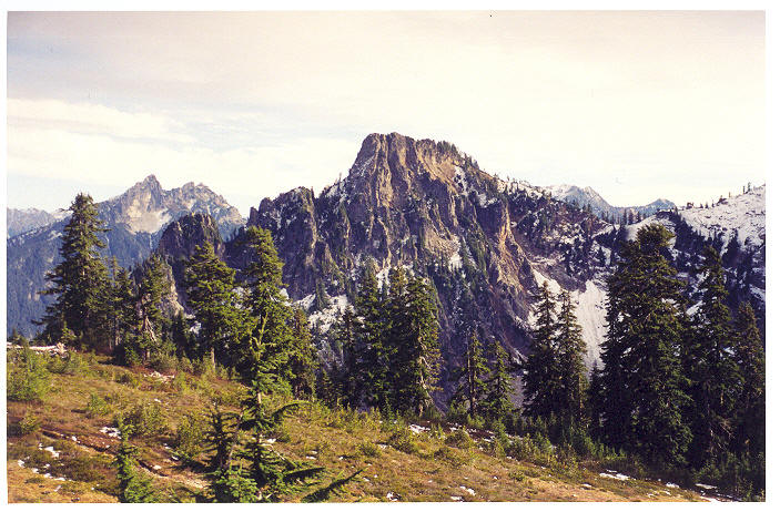
Northern Pickets. With Jack Mountain on the horizon at right and Mt. Triumph (or possibly Despair) at the right edge. Where's that taken from? Shuksan, I think. Second picture is of Mt. Blum.
-
Is it in Washington? If not, I probably don't know. If it is, I'll have to look at it a little longer.
-
Not sure, but for some reason I want to say either Metier or Joffre.
-
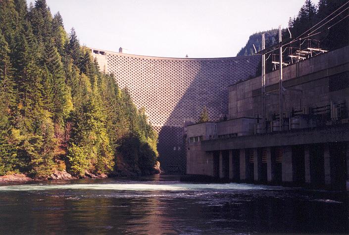
And here's one of the other dam up thattaway. Historical note: the checkerboard pattern was for a dam heightening project that never came to pass. It would have raised the Ross Lake level by something like 100 feet, thus inundating a lot more of Canada just over the border (the lake currently extends a mile or two into Canada).
-
Looking down at the valve house (pressure relief valves) of Diablo Dam. Wooo wooo wooo wooo ! My 1000th post! Wooo wooo wooo wooo !
-

My favorite this weekend photo (share) 10/3-6/03
klenke replied to Cpt.Caveman's topic in Climber's Board
Yeah, it's not Scott or Hubbard. Just read up on my green Fred. Didn't know Gothic and Castle were so slabby. -
My favorite this weekend photo (share) 10/3-6/03
klenke replied to Cpt.Caveman's topic in Climber's Board
Scott Peak in the foreground? Red Mountain [sultan] the pointy peak beyond. Mt. Stickney on the horizon. -
Contrived? What's contrived about it? I'm not sure I understand your meaning. I agree it may be long, but it certainly is all true (or based on first hand knowledge 'cuz we were just there). If you note, with the exception of Brian's boot trundle, there is very little superfulous information in the trip report. In considering the proper length of a trip report to put forth, less is less than more unless more would be less than more...more or less. If someone wants to use the information for their own beta purposes, then they can cull the unnecessary sentences as they see fit. If I remember something noteworthy in terms of route finding, then I am apt to include it. This is not saying that the way Brian and I went is the best way. It is only a way, therefore a feasible way--especially with beta in hand. Sometimes I write trip reports for fun and include humor. Sometimes I'm in the mood for just factual content. Clearly, the latter was the case for the Twin Peaks TR. Harry: thanks for the plaudits. I especially appreciate them coming from someone such as you, whose writing skills are clearly superior to mine.
-
Twin Peaks Twip Report {A picture of Twin Peaks from the north} The Route: Circumnavigation Difficulty: BW2, Class 4 scrambling, 5.8 summit pitch (5.9 in boots) Protection: Cams, cams, cams (mid-size cams being best); 50m rope; rock shoes The Personnel: Brian (Catbirdseat) and Paul (Klenke) Start/end point: Perry Creek Trail (Mt. Forgotten Trail), 2100 ft High point: Twin Peaks, West Summit (5,840+ ft) Date: October 4, 2003 Approach: (Beckey's route description isn't that good) Take the Perry Creek Trail for two miles to where it crosses the creek. Leave the trail and continue up the creek. In late season, this creek is supposed to be dry. It is dry, just further up the basin. Don't be fooled by the first 100 feet or so of pools. Shortly thereafter, the creek disappears under the gravelly streambed. From here on to the head of the basin it is actually very easy travel in the dry streambed. You will see Twin Peaks up and to the right. 1 hour to the head of the basin (3,600 ft). A lower cliff band hems in most of the head of the Perry Creek basin. A steep brushy slope heads directly east from the basin. To the right of this, where the streambed ends, is a rock amphitheater with a narrow canyon that trends up and right. Farther to the right is a semi-vegetated talus acclivity. The route we took to get above the lower cliffs was as such: Walk the streambed to just before the amphitheater and mount the spur to the right (west) of the narrow canyon. Ascend the spur for about 200 vertical feet. You can scramble rock (exposed to the canyon) or bushwhack mild stunted evergreens until at the base of the lower cliffs. At this point, make an easy crossover to the other (east) side of the canyon then traverse a slightly brushy slope (BW1) eastward for about 100 yards to another canyon with a waterfall (just a trickle late in season). At this second canyon, a low-angle slab gully proceeds eastward for several hundred yards. In some ways, this gully looks like an eroded dike because it runs parallel with the cliffs above. There are two steps in the gully that require one to exit it for brushy slopes on the left (mostly BW2 but can easily become BW3 if not diligent). Once above the second step, the gully widens and becomes more vegetated. In another 100 vertical the gully opens up to the heathery upper basin (just below the centerpoint of the aforementioned photograph). If climbing Chokwich Peak, the saddle above to the east is probably the way to go. 2 hours to here (4,800 ft). From here, one can go the Beckey way up through the ugly notch between the East and West Summits, or you can take a more solid circumnavigation. After descending via the notch, Brian and I both agreed that the better (more pleasant) approach for the peak is around its west side. In looking at the aforementioned photograph, the following features are visible: the upper cliffs, the upper talus, the lower curving cliff band, and still another short cliff band down and to the right of the summit. The idea is to take the mezzanine ramp between these lower two cliff bands. The ramp becomes a bench and shortly reaches the timbered Northwest Rib of Twin Peaks. Once at timber, turn left and climb up and over the rib or traverse steep heather beneath it until at the small saddle under the northwest corner of the summit cliffs. A stand of trees to the right (south) marks the start of an upper ledge that leads around the largely overhanging West Face to the Southwest Ridge. (I had thought there might be a rock route up this West Face but I was wrong. That was our real reason for going over there. The West Face, in addition to being overhung in many places, is devoid of any cracks for pro. There are incipient cracks which would probably take knife blades, however. Either way, it would be high-5th-class climbing.) Round the Southwest Ridge (easy) then scramble heather and ankle brush eastward under the South Face until you arrive at the only significant gully on the entire mountain. This gully has an inordinate amount of talus and blocks strewn below it and one wonders where the heck all that rock came from. 3 hours to here (5,600 ft). The Climbing: Gear up at the base of the gully. Warning: It is extremely important to climb together in the gully or on its spur margins because trundling is a major problem. It is not necessary to rope up for the lower part of the route. Scramble the mouth of the gully (class 2) to the first little step. A nice little stem move gets you above it. At the next step (harder and mossier), leave the gully for the rock spur on the right. Scramble class 4 (can rope up for this) for 100 feet past two steeper problem sections. The spur comes to a platform where the ledge Beckey mentions comes in from the east. Though we did not go this way, it is surmised that the easiest way to the top might be to continue straight (northeastward) from the top of the gully past some small trees. There is a small notch at the trees. Beyond the notch, the "gully" continues to another, more prominent notch immediately east of the summit. Turning left, one would find a class 4 ridge traverse over a small horn or two. It didn't look all that interesting from the summit. You can erect a belay at a small scrub pine on the platform or continue up unroped. The gully, which is below you on the left, more or less ends here. A low-angle slab reminiscent of the North Face of Vesper but shorter and reflected rises above the gully. The true (West) summit can be seen up and to the right of the slab. Cross the chossy head of the gully to the base of the slab (class 3). Use the corner dihedral of the slab and adjacent rock wall to place pro. The slab then steepens (easy class 4) all the way to the ridge crest immediately west of the summit. The dihedral remains in play. To complete the climb from the ridge crest would involve about 30 feet of knife-edge class 5 climbing with suspect pro followed by 40 feet of class 4 to the loose, blocky summit. At about halfway to the crest there is an alcove that is perfect (good anchor cracks) for a belay up the South Face of the West Summit. This alcove is at the base of an east-trending deep open book (an open book that's almost closed). Do not climb this open book! Precariously wedged toilet-sized boulders make climbing in there very dangerous. The most aesthetic route to the top, provided you can lead 5.8 in rock shoes, is a zigzagging crack directly up the South Face. This pitch is about 50 feet in length. It should be cleaner now that we've pitched off a lot of the loose stuff. However, the summit blocks themselves are very suspect, making the belay station below a dangerous location if they should fall. Brian led this pitch and made it look easy. Mid-size cams sunk well in the crack. The climbing features laybacks, stemming, arm bars, hand jams, you name it. If you like a certain technique, you can probably find a way to utilize it. Even a mantle is possible to get yourself onto the flat summit. Beckey says, "single visits to summit flake." First of all, it's not a flake. Secondly, two (maybe even three) people can safely sit at the summit. The hardest part of the pitch is the beginning right from the belay. The nice thing about this is that, if you fall, you'll simply land on the belay platform a few feet below. You have a diagonal finger crack to hoick yourself up, but foot features are virtually non-existent. Plus, the rock is very smooth, making it quite slick even with rock shoes. And where it's not smooth, it's lichen covered. You have to friction-for-feet the first moves in a butt-out-from-the-rock lieback until you can get your left foot into a small recess. Unto itself, I would rate this first move 5.9. But because it is at the belay platform thus negating any fall factor, it's a non-issue. Once above the first move, it's very enjoyable steep climbing to the top. Anchor possibilities abound once at the summit to bring up your second. We rappelled back down the South Face (we left a runner up there). Instead of going back via the Beckey access ledge to the Twin Peaks notch, we had to downclimb back to the mouth of the gully. Why? Well, because Brian accidentally trundled one of his boots down the gully (boot booty?). He was trying to clean the summit area. When he chucked off a rock, it careened off a flake (the only flake jutting out from the face) and plunged directly toward his boot. In descending the gully, Brian first retrieved the sock, then the insole. But where had the boot got to? We wondered just how far it might have gone. Perhaps all the way down the South Basin? Well, we found it lying upside down like a dead cow (actually, it is dead cow) at the base of the gully. That was about the only mishap during the day. We descended via the notch between the East and West Summits. The gully below the notch is very ugly, loose crap. Maybe suitable if snow-covered; very irritating and even dangerous if bare--thus our reasoning that the west shoulder approach is better. Round trip took 9 hours, 30 minutes. It took 2.5 hours to get from the notch to the car, where two post-climb beers patiently awaited their chances to earn their liquid mettle.
-
Well, you could go to next weekend's Rope Up event in Leavenworth to meet potential climbers. This event is in its third year, I believe. It is basically an event put on by the cascadeclimbers crowd. Send Beck a Private Message if you'd like more info, or simply go to the above link. Leavenworth--actually Icicle Canyon--is a rock climbing area (not quite a mecca).
-
Actually, that movie was pretty good. I love the scene (a cinematic classic) where they're crossing the expanse of water and the fire "bud" they were transporting got submersed accidentally. I can't remember if it completely went out or not. The looks on the cavemen's faces was classic.
-
Uh oh, looks like Trasky's wife just got out on parole. Looks like his cyber vacation is OVER. Winter's coming. Time to go out and chop some fagots in the woodshed.