


Cpt.Caveman
-
Posts
9387 -
Joined
-
Last visited
Never
Everything posted by Cpt.Caveman
-
Photo attached . Sorry I was not interested in photoing the route at the time I passed by. So it may not be of the best use but will give you a general idea. Also I have no idea what the benighted party did. You should check the NCNP Ranger station for a report. Many people leave reports there and some are more detailed than others.
-
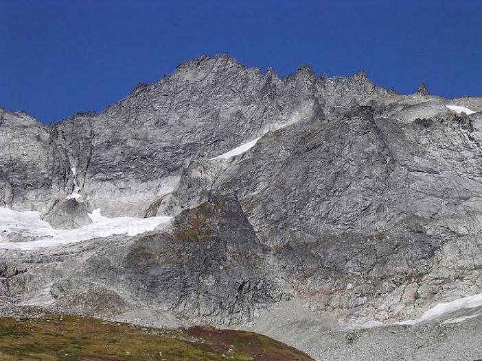
I did NOT climb the WR but did do the ERD which is a fine alternate worth examining. But there was party that had a benighting on it last weekend and climbed it successfully. It appeared to me the best way to access the glacier was to go around to the left and avoid ice that falls on to the slab. Definitely reasonable and doable by nearly anyone attempting it. There are some ice blocks in the "couloir" that are better desribed as ice chockstones. Let me see if I can dig up saturday photo that is of any use... I defninitely think that if you are persisant enough you would be able to climb the variation start left of the "couloir". Other than that I could not tell you any details.
-
The photo is obviously Phils and very nice Sounds like it was a fun trip for Colin but not the rest of the folks. Did the other two climb something else Niut Range is pretty close to the helo pad. This peak is viewable from the road and stands out nicely near Whitesaddle Mountain which is also the name which the Whitesaddle Air is derived from. The same company that flies most folks into the Waddington Range etc. There is still some untravelled terrain up in the Niuts. A nice place with no crowds. Rock can be of variable quality from my experiences and some mountains have only been climbed less than a handful of times.... Most of the mountains are less than 9500 feet in elevation. Razorback Mountain has some incredible ice routes as well as Ottarasko.. I believe the face on the right mountain in this photo is still unclimbed. Tell me if I am wrong dru. There is a Merrand\Diedrich route on the left hand mountain's face if I recall correctly. Good work Colin.
-
All the colorado climbers that I climbed with when I lived there were real nice people. They were defnitely strong on the rock - at least the lads and ladies I knew. All I remember was fun.
-
vthread in rotten ice.
-
A nice looking one. My guess is he walked in. Where is the line he did?
-
call
-
I'll give it a whirl... Thanks buddy! This is by far the MOST interesting reading I have seen here on the cascadeclimbers website. If it never produces the information some are looking for bummer. If it does we'll surely find out. TTT when was the last time we met
-
Best Fall time scrambles down da Mtn Loop?
Cpt.Caveman replied to Cpt.Caveman's topic in North Cascades
Cool- speaking of aliens... Did anyone else notice how the stars were amazing this past weekend? It was easy to identify a satellite running by and no moon... I am sure the guys on the WR of Forbidden were wishing for a moon. But they made it down safe. Was that someone here? I was actually completely worried about them... But there was nothing I could do that late at night and under the circumstances. Aloha to the lad from AK that soloed the SR of Torment and thanks for the food handout. -
My favorite this weekend photo (share) part 2
Cpt.Caveman replied to Cpt.Caveman's topic in Climber's Board
nice photo dubbledrbledave -
Right on man!! Do it!!!
-
Record times (slow and fast) for W Ridge Forbidden
Cpt.Caveman replied to goatboy's topic in North Cascades
I read thier report and I believe that they actually retreated on what I would say is the 4th pitch instead of the 5th - depending on how many bypasses and how you climb it etc. If I recall correctly the appearance after this section is that it crosses a knife edge looking section that is indeed a set of blocks on top of one another. But if you did not want to climb on top of the knife edge you could take the right hand option.. I think it was something like near the top of Mt Stuart but smaller blocks and more of them. For someone not accustomed to this type of terrain or rock might find it a little unnerving. However as I closely inspected this area I found the rocks are solid enough to climb on and around with care. Whether or not somebody might consider it chossy is a matter of opinion. I believe they were from out of state? I glanced over most of it. My humor points were that they avoided the rangers by setting an obscure camp and it bit them in the ass on their way down. Also the story seemed to have a minor undertone now and again about the Aussie thinking the Americans were idiots. -
I vote a moderator makes this thread a sticky note
-
And let the sausagefest go on... I'm excited. Although all my contributions are of gapeclimbs = moderate I will still share as long as nobody objects. I've spoken or corresponded with a few others and there will definitely be some way cool presentations I can't wait.
-
Cool stuff. I was up in Enchantments with pms a couple of seasons ago and he was too. Bummer I didn't find out who he was until later as I was in too much of a hurry on the trail. I am sure the show will be great. Waddington Range super cool
-
Best Fall time scrambles down da Mtn Loop?
Cpt.Caveman replied to Cpt.Caveman's topic in North Cascades
Interesting. Thanks -
Cool stuff. Thanks for sharing Lowell. I look forward to the final works As far as the Ptarmigan scrapbook\records well good luck finding it. I think your continued pursuits here are good. There are many folks reading and you never know what may surface. The ski shots are amazing. Even if they are wielding branding irons I am sure they could ski way better than me.
-
Record times (slow and fast) for W Ridge Forbidden
Cpt.Caveman replied to goatboy's topic in North Cascades
Soon enough bruthas In fact if weather holds go THIS weekend http://wwwa.accuweather.com/adcbin/public/local_index.asp?zipcode=98267&partner=accuweather -
Best Fall time scrambles down da Mtn Loop?
Cpt.Caveman replied to Cpt.Caveman's topic in North Cascades
Thanks. I'll scope it out on paper tonight. BTW I dont need to borrow 30m rope. I still need to return your other one. If work wasnt so hectic I would have already. I'm gonna plan my trip Juan I dont think you'll make the summit count this season. maybe next time. I know you are lurking and reading this -
What are the favorites out there? Looking for fall colors, maybe a small glacier, and about 8 hours round trips with up to 5.7 scrambling, and a good view. Is Gothic Peak fitting of this?
-
Record times (slow and fast) for W Ridge Forbidden
Cpt.Caveman replied to goatboy's topic in North Cascades
Here's an interesting story about a few lads trying out the East Ridge Direct. http://gorp.away.com/gorp/activity/climb/forbidden.htm#top Made for those with time. But there is some major humor in there. -
Call again. Your message and number was garbled.
-
I like climbing good lines. I think the definition is variable. If the grade is easy then who gives a damn about how hard it was\is supposed to be? Pick a line around your level and enjoy. If it's easy then remember the first rule : enjoy. What would split beaver be rated in a place other than squampton? BTW if you are lurking guidebook author of Squampton thank you for a good book. I dont give a damn about the ratings as much as I care where to find the good climbs. The SW BC select book is nicely laid out too. Excellent work IMHO. But you should have left all of Dru's climbs out- they are all choss
-
My favorite this weekend photo (share) part 2
Cpt.Caveman replied to Cpt.Caveman's topic in Climber's Board
Cool. I used to mistake white chuck for sloan a lot. -
Time estimate listed in Nelson's Vol I, 2nd Ed.
Cpt.Caveman replied to goatboy's topic in North Cascades
Fatboy climbers like me also agree with most of the time estimates. People approach climbing differently. Some like watching the sun rise in the morning and brewing up. Others want to be on top of the hill by then. I believe some times are debatable but most of them are pretty accurate. I would guess the times are based upon an average party. What does that mean? Well maybe more discussion.