


mattp
-
Posts
12061 -
Joined
-
Last visited
Content Type
Profiles
Forums
Events
Everything posted by mattp
-
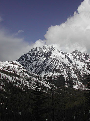
My trip report started and ended in Beverly Creek. If you look at a map, I think you'll see that is the shortest approach even after the road melts. Here's a picture from near the pass between Turnpike and Beverly Creeks.
-
How do you know?
-
They ripped out culverts, added burms, and refilled a road- cut on that road leading to Static Point, also. Unfortunately, they left the ripped up culverts sitting in the road, the biggest piece of trash you've ever seen in your life. And a friend of a friend of mine drove his 4x4 right accross the refilled road, where it must be at least 30 degrees sidehill.
-
I didn't get many good pictures. Sorry. I'll have to go back.
-
No question about it, RuMR. Sport-bolted climbing draws more climbers than traditional climbing. A sport climbing area, near the road, draws way more poeple and their dogs than does Condor, though.
-
They ripped out culverts, installed burms to block access, and I believe they refilled the grade in at least some areas.
-
I agree with some of what Mr. Mo said here: wilderness regulations are indeed "out of whack" and it seems to me that many people want to set aside wilderness for selfish or perhaps self-indulgent reasons. On balance, that is not necessarily a bad thing in that in the case of a place like Wild Sky it will lead to the preservation of wild land, and the politics are screwy, but I'm glad there are people fighting to save the mountains from mining, logging and ORV's, just as I'm glad there are people trying to undeveloped areas and open space in the Puget Sound basin. I agree, too, with some of Fairweather's sentiment. I was sorry to see the road up to Mt. Stickney destroyed in the interest of "rehabilitation" (the peak lies in what will become Wild Sky). I never got up there, but there was a road leading high up in the mountains, not far from Seattle, that offered a rare opportunity for a relatively short hike to the summit of a real mountain. I can't think of many other such places that close to Seattle. I realize that some people believe those that DO exist are often overused and become a mess, but I think it is a good thing to have these opportunities as long as they are few and far between. On one point, I disagree with Mo. I don't think they will be building trails in Wild Sky. They don't have the money. Additionally, the "Grizzly Bear" habitat rules will not allow it – unless they remove other trails in the nearby area.
-
Catbird- I disagree with your statement of "ethics" in a big way. In my opinion, a major way that we as crag climbers affect other users out there is through the littering of slings all over the place. They can be seen from as much as a quarter mile away. I believe this has even been a reason for area closures in the past. In a crag climbing environment, if you are "setting up" a rappel where others may use it, it is probably a good idea to put a sling on the tree. Add two rappel rings if you can, and preferably extra large ones so that cautious climbers don't freak out and so that when everybody and their dog feels compelled to stuff 25 slings in there it can accomodate that wad of garbage. (If you come upon said wad, please remove all but the three best looking slings, but the fact is most climbers feel compelled to strew their slings all about without regard for visual impact so that's just the way it is.) If you are going to rappel once, in a spot where you don't expect other parties to use the same tree repeatedly, DO NOT put a sling on it. Please. And please don't carry brightly colored slings around for this purpose. Get grey webbing or olive green. In the mountains, different considerations apply. At the crags, visual impact is a much bigber deal. -Mattp
-
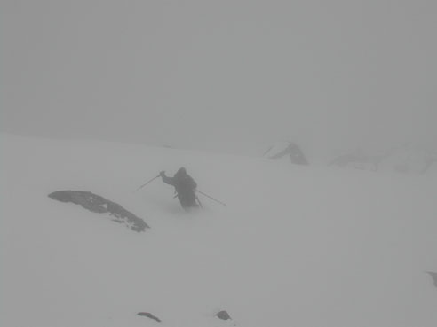
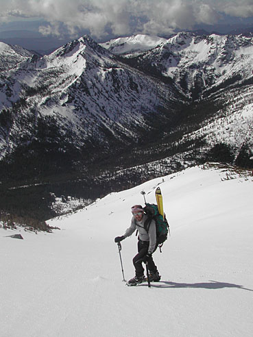
Climb: Mount Stuart-Cascadian Couloir Date of Climb: 4/18/2004 Trip Report: My buddy John and I skied Mount Stuart, via the Cascadian Couloir this weekend. The weather was "blustery," but the skiing quite good. Stuart is a remarkable mountain and it will be in good shape for at least another week or two. The road to the trailhead was blocked by a snowpatch about three or four miles short and about a mile before the turnoff from the main road into Beverly Creek. High clearance 4x4's were going through, but we thought better of it and parked well off the edge of the road so one of these guys wouldn't plow into John's brand new car. Even in telemark boots, I don't much like walking on a road. After walking what seemed like forever we were finally at the trailhead and my buddy told that I'm just a loser. It really hadn't taken very long so what was I complaining about? Not long afterward, muddy trail gave way to snowpatches and snowpatches gave way to snow, and somewhere around 3600 feet we started skinning up. At the pass at the head of Beverly Creek we got our first views of Stuart and then dropped into Turnpike Creek. We opted to cut left, where the map shows open slopes should offer some downhill skiing. In fact, these were old avalanche slopes growing in with little trees; right would have been better. We tumbled on down the hill, however, and toured on down the valley to find a crossing at Ingalls Creek (snowbridge), and dry ground near a horsecamp directly below our ski run. The climb up Cascadian Couloir was icy; I'm glad John had suggested crampons. After a thousand feet the "yousuckometer" said we hadn't gotten very far, but we continued on. In the sun, we were balling up but the sticky snow overlay an icy layer that would have made step-kicking quite a chore. The "youhavealongwaytogoometer" said we still hadn't gotten very far, but we continued on. Higher up, the snow grew deeper for the last few hundred feet but it looked like some climbers descending from a North side climb had triggered an avalanche, and the surface was a mess. The "you'regettingsomewhereometer" said we were doing OK. The summit ridge was very exciting. I had neglected to bring an ice axe, and steep slopes perched over the great void said "be careful." Powder snow and graupel overlay icy snow so it took a few kicks to get a good purchase, and I had the sensation that I wasn't going to be able to do much of a self arrest with my ski pole if I fell. We made it up to the summit –just to say we did- and headed back down. By this time it was snowing and visibility had dropped to less than 50 yards. I decided to pass up the top 300 feet below the false summit and opted to walk down instead of ski, but my friend John sideslipped and carefully picked his way down it. A few hundred feet down, I put on my skis and while the first few turns were a bit tricky it soon turned to GREAT SKIING! We enjoyed mostly easy conditions all the way down, and it even cleared up as we dropped below the cloud layer for the one short technical bit of hop turns in a steep part of the gully filled with avalanche debris. The nine mile slog back to the car was a slog. Go figure. However, the skiing down Beverly Creek was a very enjoyable cruise on gentle, largely open slopes, in great snow. Gear Notes: crampons and ice axe advisable overall, snowpack was firm enough that one could have made it without skis or snowshoes this weekend Approach Notes: Beverly Creek trailhead and other trailheads in the area are not yet accessible by car
-
I don't know about Garden Weasel, but if you're going to Three O'Clock Rock I'd start with either The Big Tree One, Silent Running, or "Till Broad Daylight" (though I'd recommend getting on "The Kone after a few pitches rather than completeing "Daylight." In my view, Board Walk is OK as far as it goes, but it is one overbolted pitch with little to recommend it as far as the actual climbing goes (it has some amazing giant knobs and it is very easy to manage so it is a good choice for a beginning leader). If you want 5.7 climbing, hit Big Tree 1. It is depicted quite well on my topo, labeled incorrectly as "Three O'Clock Rock, - Arch Area" in the link on my site, but which opens up and shows it is labelled "Big Tree Area." This has a combination of easy cracks, bolted face, and some of the mandatory DTown bush pull. Topo. If you think you're ready for 5.9 -- which most climbers with a signficant amount of climbing experience probably are even if they've never been on slabs before -- go for "Silent Running." As noted, "Silent Running" is straight forward. The first pitch can be wet, and it has some long run-outs for the Darrington flavor (up to 40 feet, perhaps), but the harder climbing is all quite closely protected. You may be skating a bit on the crux, but it is plenty safe. Topo. The combination "Daylight" to "The Kone" is also a great outing, though a little more complicated and it involves more traverssing and ends up a couple hundred yards to the left, with a rappel down a completely different climb ("Tidbits"). The first pitch (5.8) is one of the best 5.8 pitches in DTown (skip the first anchors and combine two 75 foot pitches into one). Leave "Daylight" on what is shown as the fourth pitch and jump on "The Kone" to what is shown as "The Kone's" third belay (variation right is more "sporting"). Two more pitches of slab dancing at a moderate grade lead to the top anchors. Topo. If you like these climbs, or if you want to jump on something harder right off, "Total Soul" has eight pitches of great climbing. It is a little harder, but it is also straight forward and you can rap off at any belay. It may be a bit gritty early in the season, and it doesn't look all that great from the bottom, but it is a good and varied climb with mostly pretty comfortable belays. Topo.
-
Yup. I think, too, that I was called cynical when, not long after 911, I said I believed the conspiracy theories that they'd try to pin Twin Towers on Saddam, or at least connect the dots in a way that would allow them to invade Iraq. You may think I'm an ugly cynnic, but lets see what happens.
-
Wouldn't you expect us to be "getting warmer" as the election grows nearer?
-
OK HTML Redirect. But no matter how many times I hit "back", it doesn't go back. It used to open up and take my entire screen, so I couldn't back out without using the "Exit" button or something. I brought this to his attention a month or two ago, and it appears that he took care of it: now I see that it is opening up just a partial window so I do in fact retain control of my computer.
-
Three posts above Mike Layton's, I posted the link. If the scroll button is broken, here you go. Warning: Dave's site is done in Flash, so it will take over your computer. You cannot press "Back" to get back here and spray, and you won't have multiple windows available if your boss comes around the corner real quick.
-
Yup. It's a great guide. My website will get you through a test run in the area, and more, but Dave's "book" is well worth it. His drawings are fun to look at, he has tons of pictures, and there are lots of excellent routes in there that have never been published elsewhere (even though some of them are 20 years old).
-
They work for me!
-
Mike- Do you have any stats or perhaps a general impression as the the relative success rates of parties that go for the "traditional" 2-day itinerary as compared to, say, a 3-day plan? How 'bout the 1-day'ers?
-
Coming down from Mt. Hardy, I don't think you'll hit Swamp Creek but, as I said, veer right (west) down low and end up in a small drainage that runs of the center of Hardy's S. Face (rather than Swamp Creek). You could go up that way, too, but you may or may not find it right off.
-
(1) Mt. Hardy is pretty good. It must be about a 3,000 foot run, south facing, and it is moderate in steepness but steep enough to really rip. I believe you park at "Swamp Creek," and head into the woods and stay generally up and left to treeline, with some crawling over logs. For some reason, we started on the right side of the stream and quickly crossed over left. The upper slopes lead pretty much directly to the summit, with about 50 feet of step-kicking. You may want to bear sligthly right (westward) for the lower part of the descent and come out about a mile down the road from where you start. But it's probably easier to find it the way I describe here. (2) A classic highway 20 tour is Silver Star Mountain. If the snow is consolidated on N. Slopes, I'd recommend going up Burgundy Col, for 3000 feet of kicking steps. Then drop onto the glacier and ski up right to it's head. The run down is great, and the bowl into Silver Star Creek is good too. You'll find it nasty going out Silver Star Creek but it isn't far. You end up 5 miles down the road. This is a fairly full day for most parties, but not at all unreasonable if you are experienced and even reasonably fit. I'm not sure this would be a good tour for the snowboarder, because there may be too much flats involved, but it is a scenic ski tour with one of the areas highest peaks involved if you can scramble class 3 rock with snow on it in your ski boots. (3) The broad gully directly above the hairpin below S. Early Winter Spire is a great run, right next to the road. It's a good, straight up - straight down shot, and may have a staircase of foot steps already in place. If you have extra energy, you can drop into Copper Creek on the other side of the little peaklet above and left at the top of the gully. If you do this, then climb out the end of Copper Creek to get back into creek leading down to the hairpin, you'll have done the "Birthday Tour," one of the areas more famous day trips. (4) The South Slope of Cutthroat is another roadside run that is quite nice. There's usually a wide spot where you can park and look directly accross at it. If the lower slopes are not bare, it is a good and straight forward trip. ...
-
This is something I hadn't considered before, but I think it's quite true. With gyms and competitions and training regimens and magazines and X-games and generally more mainstreaming of the sport, people who are athletic and gymniastically inclined are indeed more likely to find their way to the crags. This is almost certainly one of the reasons for some of the expansion of the technical high end. ---- I think we are all in some measure of agreement that performance standards have greatly increased with the advent of gym and sport climbing. One question that occurs to me is how does this affect climber's longevity with the sport? It seems to me that with this emphasis on how hard we can climb we are likely to see people drop out of climbing sooner when they decide they can't keep up with their peers or are past their peak or something. If you look at climbers of today who have been climbing for 30, 40, 50 years, some of them were once and maybe still are "gifted," but many are just normal average climbers who still find it fun.
-
I hope you're back in time for this year's cc.com spring picnic 'cause you're this year's poster girl!
-
Posturing, name-dropping, and elitism are not new to high perforance rock climbing.
-
I was referring to Dave Morales. A guy who got into climbing in a big way, real fast, and was climbing 5.13 within little more than two years - if that. An enthusiastic climber who could pull down not only the sport and trad climb, but ice as well. I never heard of Dave's spending much time in the rock gym, but he definitely had the focus and discipline that Dru talked about. And he'd climb with a bumbler like myself and have a good day doing that, too.
-
Most of the spray lords are not high performance rock climbers. Those guys are generally happy climbing, and don't seek to spray about it. One of the best climbers in the state, who has now taken up kayaking and is probably kicking some butt in that area too, is a guy most of us have never heard of.
-
Tex- Do you suppose that is why he's hanging 20 feet below his bolt?
