mattp
-
Posts
12061 -
Joined
-
Last visited
Content Type
Profiles
Forums
Events
Everything posted by mattp
-
From Lowell Skoog's website: Northwest Skier, 1970 Jan 16, 1970, p. 29: "Mansfield, Tom, "Yodelin Opens" * Yodelin ski area opened on December 27, 1969, with a 1,800-foot double chairlift, a rope tow, and a three-story Tyrolian-styled lodge. Nason Properties, owned by W.C. "Wendy" Carlson and his wife, operates the ski area and lodge and handles the sale and development of the Yodelin village. A total of 184 homesite lots are available and several all-season recreational homes have been constructed. Future plans call for a condominium ("Lichtenberg Haus"), a cable car on nearly Lichtenberg Mountain, and four chairlifts on Barrier Ridge. The 3-1-70 issue (p.1) includes more information about Yodelin, plus three pictures.
-

Former Place Names, Spellings, Pronunciations
mattp replied to catbirdseat's topic in Climber's Board
I've got a friend who was in Mother Love Bone but not Pearl Jam. -
Former Place Names, Spellings, Pronunciations
mattp replied to catbirdseat's topic in Climber's Board
I'm guessing you are thinking Mother Love Bone became Pearl Jam, MaryLou, but I'm not sure it was an exact transfer. Perhaps some of the same band members but not all? -
No, you won't need a rope. You won't really need the axe either, but if you do elect to complete the snowclimb finish it will be comforting. I bet the entire crest between the summit and the knob to the southeast will have a cornice or pseudo-cornice on it right now, so the doggie crawl may well turn out to be the way to go. If you don't have an axe, turn your skis over and use the bindings for traction claws.
-
Yes, we'll see some pardons for sure. With any luck, it will be Bush, Cheney and Rumsfeld who will need pardons.
-
I don't think you'll have too much trouble crossing the creek, Dave. It isn't that big. By the way, if you are aiming for the summit via Dave's proposed route up from Lichterwasser, you might want to bring along an ice axe for the doggie crawl finish. The steep climbing is short, but it is exposed. If you reach the main crest off to the left somewhere, you can skin it right to the summit.
-
I gotta say they always DID look and feel a bit home-made. But I like them never-the-less and I hope they can get straightened out.
-
I sure hope they can convince me that the problem is limited to more recent productions 'cause I really like my Aliens.
-
Check this out: web page Even if Dean is overstating the Dem's innocence here, the obvious and undisputed fact is that this was ten to one a Republican scandal. If the conservatives are trying to say the Dem's did the same thing IN THIS CASE they are flat out lying. (Not that there havn't bee plenty of Democrats who were/are crooks.) They cite Patty Murray, for example, as having received $ from Indian tribes that Abramoff represented. Might these be the tribes he called "troglodytes" and stole millions of dollars from? Does anybody allege Abramoff told these tribes to donate $ to Murray, or that they would not have donated $ to someone who had promoted their interests for many years without his recommending that they do so? Without some connection between Abramoff and the donations cited, I view an allegation that they are part of the Abramoff scandal as misleading at best, and more likely a deliberate lie.
-
Big Jim is rather impressive when viewed from High Camp, to the West. I've wondered about heading up there from Hatchery Creek.
-
-
In periods of high avalanche danger, I don't think you'll safely make it all the way to the summit by that route but perhaps nearly so. I'd recommend heading into the woods after heading straight ahead at the big hairpin and then bearing left, to climb up to the Lake. Form there, staying right may keep you somewhat out of avalanche terrain but I remember there being a few terrain rolls that may be worriesome -- and then when you get to the summit itself you will either have to doggie crawl up an exposed and steep snowclimb on the right or cross beneath and climb over a large cornice on the left.
-
The Aussie pie is OK, in my opinion.
-
As stated, there really isn't a way to avoid avalanche slopes above Colchuck Lake and there has been an awful lot of new snow coupled with high winds lately. If you want low-hazard conditions, wait until the weather settles -- or wait until it rains to 8500 feet -- and then wait a few more days.
-
AMS can be a fairly big issue even on some of the higher local mountains. And, in fact, a few have died from HAPE or HACE on Rainier.
-
How do you get from the Lichtenwasser to the summit safely in avalanche conditions? The way I've gone up from there certainly feels more secure than the west and south faces, but not totally safe. It is a scenic approach to the peak, though, and generally moderate in angle but there is about two hundred feet up the side of the ridge directly below the lake where I usually take the skis off and crawl because it is too steep to skin up in most snow conditions.
-
Why don't you just stick to speaking English the way the rest of us do and leave semantics to people who care? Most of us on this board are not hydrologists, and when we say "it rained for two days," or "we had a week straight of rain in the Bugaboos," we don't mean it never let up at all.
-
I mean we'll see you there, right?
-
I don't know how you learned to speak, Dru, but a day "of" rain does not necessarily mean 24 hours non-stop rain to anybody but maybe you.
-
OK then. We'll Archie and RumR at 8:00? Or are you simply Internet stalking in violation of Federal law?
-
Maybe they have a private room for you in the back.
-
And, might I suggest, Archie and Catbird are hereby cordially invited to fight it out over the pool table. Rumr too.
-
Unless your intent is simply to annoy, while using an anonymous Internet identity, one should NEVER enter an argument about where pubclub might be or who is going to be there -- unless, of course, they intend to appear at said event.
-
Leavenworth has great climbing generally one to three pitches, though there are some longer routes there. The scenery is great and, as Trog noted, the weather tends to be slightly better on the east slope of the mountains. The camping is good. 2 1/2 hrs drive. If you want steep cracks, Index is closer to Seattle and offers some of the best crack climbing anywhere - generally one to five pitches. 1 1/2 hours drive. Camping is limited. If you want longer routes with slightly more of a wilderness feel, tending toward slab climbing, Darrington has several granite domes only 1 1/2 hours drive from Seattle. It is a rainy area. Camping is good. Depending on the Spring weather, a variety of granite rock climbs with an alpine feel may by then be high and dry, with some snow on the approaches, up at Washington Pass (3 1/2 hours). Great views! Good campgrounds are nearby. For world-class climbing, head to Squamish. 3 1/2 hrs drive. If it rains, as it often does on Memorial Day, head to Vantage for one-pitch sport and trad climbing in the Washington desert. Tieton is slightly less reliable, but also a good wet-weather refuge from the west side rain belt. MaNY Of these In Eric and Lucie's bus trip - look for it with Google. Google "Index rock climbing" etc. and you'll find other sites, too (like my Darrington site). A summary or profile of many Washington climbing areas appears here: Washington Climbers Coalition web site
-
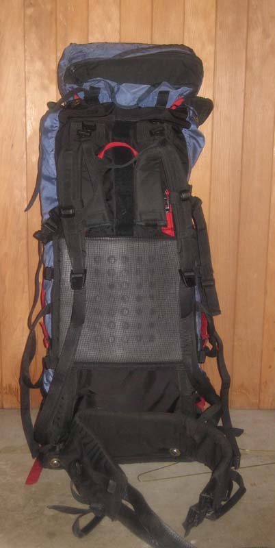
You can see this has zipper access to the bottom of the sack; it also has straps on the top lid to convert to a fanny pack, and it has "bayonet" frame stays, meaning the upward extensions of the frame above neck level can be removed so that you have better ability to tilt your head back, or added to support a higher load. The waste belt is the most comfortable I"ve ever carried even though it is not some super padded ergonomic affair like so many packmakers seem to feel is necessary. I can even throw in the side pockets that came with it.