Leaderboard
Popular Content
Showing content with the highest reputation on 08/19/22 in all areas
-
Trip: PRIMUS PEAK (8508'), TRICOUNI PEAK (8102') - EAST RIDGE & NORTH RIDGE Trip Date: 08/13/2022 Trip Report: PRIMUS PEAK (8508'), TRICOUNI PEAK (8102') – Thunder Creek Trail Approach – AUG 13-15, 2022 (Sat, Sun, Mon) Another perfect weather weekend for climbing. Temp was right around 80 all days. I originally planned to climb Tricouni, Primus & Austera Peaks. After climbing the first two peaks and doing the math, I would have needed another full day and more supplies to bag Austera from this side of the mountain, which wasn’t going to happen. Saturday: I started from the Colonial Creek Campground area at 9:00am. I headed up the Thunder Creek Trail to McAllister Camp arriving at 11:30am. I planned to cross the bridge over Thunder Creek to the McAllister Camp on the other side of the creek. That is where the start of the climber’s trail up to Primus Camp is located. Having climbed Primus before, I knew this was the best option. I walked right by the trail to the creek because it was covered under a pile of sticks and the old signage was gone. I doubled back and headed down the trail to find that the bridge is completely gone too. Not damaged or collapsed, but completely gone. I looked up and down the creek nearby for a possible log jam crossing. No luck at all, the creek was high and deep and moving fast. There was no way I was going to attempt to ford the creek. I decided to move on to Tricouni Camp since the camp is located before Fisher Creek feeds into Thunder Creek, hoping this would mean the creek would be more crossable. I headed through Tricouni Camp to Thunder Creek and lo and behold, a fantastic log crossing with three big trees together all the way across the creek. It was 12:45pm by this time and the new plan was to cross the creek and go straight up the mountain side to connect with the climber’s trail on the ridge. I knew it was going to be steep the whole way. The bushwhack started out good, the terrain was pretty easy going. That ended pretty quickly. I came across a well established game trail mostly of goat tracks. The goats have always been good to me, so I followed the game trail up the best I could. I started to hit vertical cliffs around 4000’ so I traversed toward Tricouni Peak and through several steep gullies, again following the goat trail. I finally made it to a boulder field and headed straight up. It got steeper and more loose but I kept fighting my way up. Finally at around 7:30pm I popped out onto a familiar looking plateau at about 5700’. Sure enough, the climber’s trail to Primus Camp was a little way up from me. I reached Primus Camp at 8:15pm. Time enough to setup camp, eat and go to sleep. The climb up was tougher that I had expected and took much more time. The goats are a bunch of crazy tough bastards, thank god, just my type. Sunday: I was up and moving at 7:00am. Tricouni was first on the list. I headed for the toe of the North Ridge and started up. The ridge start is class 3-4 rock then it eases up a bit to cIass 2-3. I looked down the side of the ridge to see a mountain goat hanging out on the cliffs below. He looked surprised to see a human in the area and got the hell of a dodge in a hurry. I headed up to the main snowfield. The snowfield is moderately steep and gets steepest at the top. Snow conditions were pretty good and firm. Once at the top of the snowfield I was staring at the ridge up to the top. Exposed class 3, 4 rock, somewhat loose in sections. I took my time and made sure my holds were good. The ridge got narrower, down to about 2’ wide in one section. I climbed along the side of the upper snow section with an overhanging cornice to the summit area. The cornice was ready to come down. A 6’ wide section came down as I was working my way to the snow gully. I climbed up the left hand side watching the cornice carefully for any movement. The rest of the cornice will probably come down this week. Once above the cornice section, it was easy climbing to the summit arriving at 11:15am. Beautiful views in all directions. I found a summit register from 2004 with only two party entries. One entry only had the date listed. I’m assuming they must have lost the pencil at that point because there was no name and the pencil was gone. The register is a zip lock bag with a vitamin bottle inside, hidden in a small pile of rocks on the summit. Bring your own pencil and maybe an extra to leave behind. I started down from the summit heading toward Primus. There is supposed to be an “easy” snow finger down to Lucky Pass. Easy my ass! The snow finger was steep with halfway soft snow and shitty moats on both sides. I was about 75% down the snow finger before seeing that the bottom section had a 20’ gap with 10’ of vertical snow. I had to climb down into the moat and wedge myself between the smooth rock wall and the snow. The snow was not solid enough to climb down with crampons safely, so I alternated between the snow and the smooth rock until I was close enough to jump down if I slipped. I didn’t slip but it wasn’t fun. I finally made it down to Lucky Pass at 1:00pm. The name is fitting. The pass is in a perfect location with great camping and a nice little stream for water. The view is fantastic. Klawatti Lake below would make a great camp area. Looking back at the “easy my ass” snow finger on Tricouni, I noticed a goat path down the side closer to the pass. If I had known it was there, I would not have taken the snow finger down to the pass. Next stop was the Primus summit. I climbed Primus before via the North Ridge in 2014. That was low 5th class rock. The East Ridge of Primus is mostly class 2 bouldering with a little class 3 here and there. I made it to the summit at 2:40pm. I was back to Lucky Pass at 4:00pm. I looked over at Austera Peak and looked at my watch and went through my supplies. There was no way I was going to get to that peak and make it back to camp in any reasonable amount of time. So I headed for camp cutting across the glacier in front of the South Face of Primus. The glacier was in OK shape, soft but manageable. I wrapped around down to the glacier above the lake and over to the glacier below Tricouni. It’s a bit of a bowling alley below Tricouni so I opted to climb on the glacier halfway floating on the Lake. It worked out well, I saw several boulders on the glacier around that area so I knew it would hold my weight fine. I made it back to camp at 6:45pm. Monday: I packed up camp and was up and moving at 7:00am, heading for home. I didn’t want to follow the same route that I came up on as the gully crossings were not fun. My plan was to drop down the climber’s ridge trail a ways and then drop off the side into the Thunder Creek area, hopefully running into the Tricouni Camp’s huge log crossing. I dropped down the ridge trail to about 5000’ and decided to make my turn down toward the creek valley. The route started as a fairly steep gully down the side of some cliffs. It looked somewhat well traveled, probably by goats. Careful vege belay technic was crucial. After the initial loose steep start down the gully, I spotted what looked to be a dried creek bed down the middle. I follow this dry creek bed as far down as I could. There was some wet mossy sections along the way. I was using vege belays the whole way down. I reached a cliffed out section in the creek bed and turn right into the forest to get around the cliffs. The forest vege belays didn’t work very well. Most of the branches were dry and brittle and tended to break when you needed them the most. So I aimed at the areas that had the most trees to grab onto. I stayed close to the creek bed but in the forest. There were cliffs mixed in here and there put they usually had hidden shelfs that allow me to get around them. Again I was following goat trails most of the way down. The steepness started to ease up and I knew I was close to Thunder Creek. I popped out onto the creek side and checked my elevation (2060’). This was close to the Tricouni Camp log crossing. I looked up and down the creek and didn’t see the huge log crossing. I decided I must be a little too high up so I followed the creek down thinking I’d run into the Tricouni log crossing soon. After about a half hour going down stream I came across another nice log crossing the creek. It wasn’t the original log crossing but it was too good to pass up. I was on the main trail side of Thunder Creek at 11:00am. I wasn’t sure if I was above or below Tricouni Camp. I wandered around massive amounts of downed trees in a swampy area until I saw a sharp turn in Thunder Creek. I pulled out the map to look for the turn in the creek and it put me closer to McAllister Camp than Tricouni Camp. I knew the main trail was close even though I could not see it. So I just marched straight up the hillside and sure enough I ran right into Thunder Creek Trail at 12:00 noon. I was on the trail just above the old bridge crossing that has disappeared at McAllister. The trail back to the parking area was uneventful and actually kind of boring compared to the bushwhacking. I was back at the vehicle at 3:20pm. Since the McAllister bridge is completely gone and probably will not be rebuilt, the route I took up and down will probably be the new way to Primus Camp for the future. Hopefully with more use by goats and people there will be a more clear cut path to follow up to and down from the Primus area. Right now, it is one hell of a workout getting up and down. I was beat by the end of each day. Some Tips and Notes: 1. The McAllister bridge over Thunder Creek is gone and there are no log crossings nearby. 2. Tricouni Camp has an excellent log system crossing Thunder Creek. 3. Climbing up the hillside toward Primus Camp from Tricouni is steep and loose. 4. If you see a creek bed on the way up, follow it. If you see a well worn goat path on the way up, follow it. They will be the easiest ways up. 5. Bring work gloves for the extensive vege belays needed both up and down. 6. There are bivy / camp options near the Tricouni Summit, the Primus Summit and at Lucky Pass. Travel Time for reference: Saturday: Trailhead to Primus Camp (6000’) – 11:15 hours. Sunday: Camp to Summits to Camp – 11:45 hours. Monday: Camp to Parking Area – 8:20 hours. Total Mileage: around 26 miles Total Elevation Gain: around 8100’ Gear used: Trekking Poles, Ice Axe, Crampons, Helmet. Logs crossing over Thunder Creek at Tricouni Camp. Bushwhacking around 4000' on way up to Primus Camp. Finally on the climber's trail with the objectives in sight. Tricouni and Primus from camp. Tricouni North Ridge. Snowfield on Tricouni. North Ridge to Tricouni Summit. Looking down the North RIdge route from Tricouni Summit. Looking back at the Tricouni snow finger down to Lucky Pass, notice the goat trail on the right side. Lucky Pass view. Klawatti Lake below. Forbidden in the background. Primus East Ridge, basic class 2-3 rock. Primus summit memorial. I have to admit I had a lump in my throat and a tear in my eye. One simple line "We Miss You Son". I couldn't image losing a son so young and trying to move on in life. I climb in the mountains to get closer to heaven and it seems others do to. Austera, Klawatti & Eldorado from Tricouni. Primus on the way back to camp. Tricouni on the way back to camp. Back to Camp. Some nice views right off the side of the main trail. A very beautiful area that charges a hefty fee in the form of suffering. Well worth the effort. Gear Notes: Trekking Poles, Ice Axe, Crampons, Helmet. Approach Notes: Park near Colonial Creek Campground, head up Thunder Creek Trail, cross logs over Thunder Creek at Tricouni Camp.2 points
-
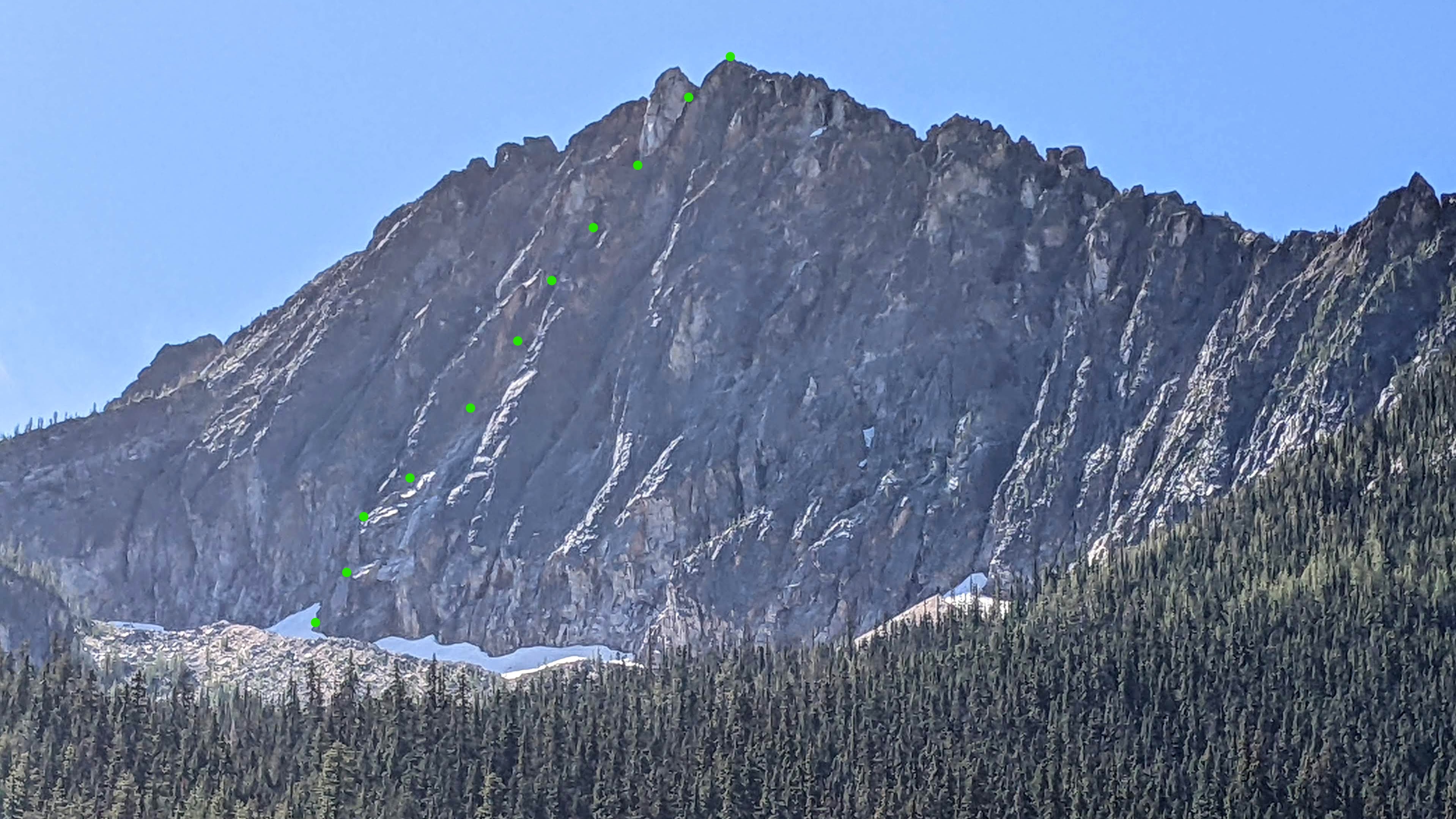
Trip: Holliway Mountain - North Face Route (aka "Scary Bear Attacks") D 5.9+ new route Trip Date: 08/14/2022 Trip Report: Let's start with a John Scurlock photo of this (likely) previously unclimbed face; Holliway's north face is on the left, Golden Horn background right: Here's a shot I took from the trail: Rolf Larson and I bring you a cautionary tale about this attractive nuisance. Our main candidates for an ascent were the two longest ribs that lead up to the two high points you see above (the true summit is on the left, and appears lower). The one on the left had a series of towers that led to the brilliant white -- and largely blank -- spike that forms the summit, while the one on the right appeared more straightforward. We kicked steps up firm snow to the footing of our preferred rib on the right. After futzing around with a difficult moat pitch, and finding a barely passable anchor poised below what looked like a difficult and very spicy next pitch, Rolf wisely downclimbed back to the snow. This cost us 3+ hours. We wandered left on the snow to "scout", and spotted some snow leading up to easy access to the rock, below the second-best left-hand rib and just right of a garbage-chute gully. Standing on the still-hard snow, contemplating the idea of beginning the route at 11:30am, one of us asked "You wouldn't let us do something stupid, would you?". This was a stupid question directed at the wrong person. So both stupidos headed upward to scout. Looking up; we began climbing off on the left, below the high point of the snow, where it makes a prominent triangular nose pointing right. Our false start was the furthest right high snow point. Our top-out on the sub-summit is the high point to the right of the V-notch; the true summit is the white spike on the left. I got the first pitch (5.9+) and it was fantastic, and would be popular if it were at a crag--fun climbing with a little bit of everything on solid rock. The uphill was all downhill from there. Rolf's second pitch (5.8?) went up a chimney that had some fun moves, but also some loose killers that he danced around. Our next several pitches took a left-hand ramp above the gully splitting the two main ribs, a couple more in/across the gully to take ramps on its right, and then we found a way to leave the gully rightward to gain the originally desired right-hand rib to the sub-summit. After pitch 2, the climbing in general wasn't too steep, but there were occasionally difficult moves; and, it was often run out and loose, requiring careful rope management. A few pitches after gaining the right-hand rib, we stood on the 7,920' sub-summit and took in the sunset. We were 9 hours on the route. We descended to the south, hemi-circumnavigated around the east side of the mountain (via headlamp and moonlight) to get back to our packs, then thrashed down to our pleasant camp at the river, arriving at around 2am. Not that anyone will bother, but FWIW, happy to provide details for the descent -- including a plausible more direct route with daylight -- upon request. After the first pitch, due to the loose rock and scarce anchors, bailing would at minimum be risky and costly. Future parties might enjoy exploring the many features on this corrugated face, but should bring a bolt kit and a sense of humor. The line required 10 pitches total. Approx route: More pics here: https://photos.app.goo.gl/zTcs4kQdwBFhEdKc7 Here's the namesake bear (there's a video series of same name too, and on the approach was bear scat and a bear hunter): Gear Notes: We had doubles through 2 when including tri-cams, a single 3, and pins. Rolf used one pin at a belay. A single 70m rope. Approach Notes: West Fork Methow River trail, then PCT (total approx 10 miles) to camp on Methow River; then up a couple thousand feet through brush and forest1 point
-
Did the Chuck Spiekerman Memorial Ascent of Summit Chief yesterday with another buddy of Chuck's, and followed (sort of) his beta here -- in that we went in and out via Escondido Ridge and mostly made sure to find the trail along the ridge. We did make the ascent more interesting by selecting the wrong notch and climbing a false summit first before traversing to the correct one. Tons of people camped at the first of the Vista Tarns right off the PCT but not a soul at the second which was maybe 5 minutes more walking. So nice. Good day out and it was only 12 hours tarn-to-summit-to-trailhead but those last two mosquito-infested miles to the trailhead were INTERMINABLE. Fortunately fish n chips at The Brick dulled the memory.1 point


