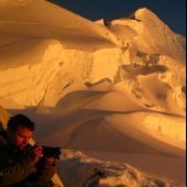
Josh Lewis Posted March 19, 2010 Posted March 19, 2010 Trip: A Mountain I have not Forgotten - Date: 3/14/2010 Trip Report: This trip took place March 14, 2010 on Sunday, the people who came were me and Collin (Rokisgud). I have been up the Perry Creek trail many times when I was younger, when I first started getting a taste of what real adventure was like. Those were the days I once said, but now I still live in those grand days, after all, I am never finished! Most of the photos were taken by Rokisgud. Setting up the trip at first was a bit tricky, I wanted to call Gimpilator for some information on Mount Forgotten but when I was about to call, one of my brothers (not Michael aka Jimbopo) did not let me proceed and said I had to get mom's permission. My mom was not home that night as she is not a lot of nights, and when I called there was no answer... as usual, and I left a message hoping she would call back which there was no call back, or atleast not that night. So then I ask my brother "can I atleast ride my bike to her?", then he grumpily tells me "no!" and I leave the room and am outraged by this point because it seems unfair that not only could I not get out this time, but it seemed very possible that this could happen again! And because my mom is not home very often these days it would take some advance planning. I decided on Mount Forgotten rather than Mount Dickerman because even though I knew we had a 99% of making the summit of Mount Dickerman, Forgotten had a decent chance although even though I knew there was still a good chance we would not summit, making it most of the way would be more fun... fortunately I was right. I go down stairs to speak with my land lord and tell him about my situation, fortunately he lets me use his phone which was nice because now I was able to call back Collin to confirm the trip and tell him where we were going. Another misfortune was that I could not print out a map for the place because the printer was in my brothers room and he would probably catch me and know I was trying to go for a hike. Don't worry folks I told my mom and got permission from Michael to go on this trip, and about 100% of the time my mom says its ok to go for a hike. I wake up at 6:02 a.m., or atleast thats what I thought I woke up at, I had forgotten about day lights savings time, and about 1 minute from me waking up Collin knocks on the door. "Blame it!" I thought to myself, I had expected to have a hour to get ready but instead he was there an hour ealier than expected, fortunately Collin was patient while I hurried around the house packing my gear and having a speedy breakfast. I would have packed the night before but I did not want to be caught by my brother packing for the trip. Once again another problem was I did not have a camera for this trip. Part of the reason was related to my Eldorado Peak Trip because the camera went from occupation of my land lord to my brother who would not allow me to see it unless there was a hike, and then it went to my mom, which I did not get to see before this hike so I was once again without, fortunately Collin took plenty of photos. :up: Once we left I was excited for a new adventure, when passing Big Four on the way we stopped and as Collin was taking some photos there appeared to be a avalanche coming down the north face which was an impressive moment, I've heard them in the past on Big Four, but they don't loose there interestingness. It was a nice sunny day to start out with clear skys, when we got to the trailhead we decided to put on gaiters right away because we knew we would be hitting snow very quick (I believe this might be the last time this spring we see low elevation snow that is fresh). We made good pace travelling through the valley above Perry Creek. By the time we got to the water falls it became less obvious where the trail was. Both of our attitudes were "who needs a trail?" because then we decided it was more fun to go strait up the mountain, and besides it was a hassle figuring out were the trail was. There was a bit of dealing with bushes but soon we found the trail again covered in snow. Later it again was hard to stay on the trail due to eventually not really knowing where it acually was. We decided to put our snowshoes on, which did not help that much but what the hey, better little support than non. As we continued upward the slope naturally got steeper and I started to slip with my snow shoes which is when I decided it would be a good idea to take them off. I also ditched my ski polls because I believed they would not be needed anymore, which I was not disappointed in my discission. At one point I sink in a hole which was a bit annoying but atleast was not like Eldorado. It was now time to whip out the ice axe, and the more I went up, the more fun it was becoming. Most people would of been nervous on this slope, but after years of scrambling experience it feels natural to me, and Collin seemed fine with it. As we got near trees I used them for extra support and had to figure out how to slide myself past a few, Collin got stuck until I took his pack and he was able to get though. At the top of the steep section I was now ontop of the ridge, or atleast almost atop, in front of us were cornices all over the ridge, I was amazed to see a 12 foot cornice, perhaps bigger right next to us which at the time I thought we would have to pass to get to the summit of Mount Forgotten. I looked down the cornice ridge and thought it would be more fun to go down the ridge and head over to what appeared to me at the time to be a different summit. Once again I turned down a summit because I would rather choose a more fun adventure. "A fork in the road, I choose the road less traveled by. It has made all the difference." -Robert Frost The summit we were heading for was indeed Mount Forgotten although at the time I was wondering if it was Devils peak because the South Face was so steep looking, but then I did not remember Devil's peak being so far est which had me confused. I had wished I could have broughten a map, or atleast done more research on the place. As we head down the ridge I realized I should have broughten a better pair of gloves, my hands became quite cold quite fast and the gloves I was wearing were thin and hard to put on each time I took them off. After being careful of passing a cornice we had to go downward to get to the next part of the ridge which worried me because it looked steep all around, fortunatly I found a spot that worked although there was a "jump" or mini drop off that I had to do a rock climbing move to get down, because the slope below it was steep and I did not want to fall and then go sliding down the slope. Fortunatly it was not as bad as I at first wondered. Then we started hitting deeper snow. Breaking trail was much easier than it has been in the past, not to say it was easy but in the past this would of been so much harder for me. As we trevaled we could see there was some incoming clouds, the sky had already lost its blueness. Eventually as we kept going I started to become tired of breaking trail so I decided it would be nice to have Collin break trail for a while which was a relief. As we get closer to the summit ridge of Mount Forgotten we see that there is potential for avalanche danger, according to the avy forcast it was at a 3 that day. In the gulleys ahead we could see avalanche debree and I earlier was noticing some slabiness on the slope. The cornice formation was impressive by this point. Collin said he did not like what he was seeing so I decided to offer for us to turn around. He said "would you like to call it?" and I decided it would be the safer thing to do. After all we had fun as it was, and it was not worth the risk heading further up, plus the dark clouds coming in did not look friendly, the sky had a purplish and black look to it which I wondered if we would be rained on the way back. To my amazement the foot prints we made 10 minutes ago were already starting to blow away due to the wind creating a windblown effect. We had to head back up to get my ski polls, plus we knew that this way worked for the way down. After traversing some of the slope I headed back up to get my ski polls, then we went down in good time doing run glassades. Then I got a few sit glassades in. Collin and I had much talk on the way down about our adventures and such. Getting the rest of the way down was decent. I'll admit my legs were pretty soar for a few days, partly because of breaking all that trail (kicking in the snow). Thanks Collin for taking me here and taking the photos. Once again another great trip. Quote
genepires Posted March 19, 2010 Posted March 19, 2010 dudes gets out! how many winter summits has it been this winter? nice job. Quote
mountainsloth Posted March 19, 2010 Posted March 19, 2010 Fun in the mountains again! Nice work! Your TRs take me back to my early adventures in the mountains. Sounds like your brother is lame... reminds me of mine when I was your age. Don't let him get you down, 15 years later, my older brother is one of my best friends. Keep up the good work fellas! Quote


Recommended Posts
Join the conversation
You can post now and register later. If you have an account, sign in now to post with your account.