Roger Posted March 24, 2004 Share Posted March 24, 2004 Climb: Mt. Hood-Reid Glacier ski descent Date of Climb: 3/20/2004 Trip Report: The plan was to leave a shuttle at the Ramona Falls trailhead, skin up to Illumination Saddle from Timberline, and ski all the way down the Reid. The USFS had other plans, as the road to Ramona Falls was closed just off Lolo Pass Road at the bridge over the Sandy, which would add an extra 3+ miles at the end of the day. Oh well. Weather was perfect and warm on Saturday, and we got to Illumination Saddle around 11:45 with time to burn. Ate a leisurely lunch, talked with some folks (met Thrashador – thanks for the beta), and generally dicked around while letting the sun work its magic on the west side. We started down around 1:00, traversing right from the saddle and then dropping in: There was some great snow up high – the key was to stay in the big pockets of wind deposits: Great views of the Reid headwall and Leuthold's from the flat part of the glacier: We headed far right to avoid the cliffs and icefall in the middle of the glacier, into a steeper and narrow section next to Yocum Ridge that opened up into a sweet, long fall line with great snow that provided the best turns of the day. Note skier and tracks at center left of this photo: Traversed to the right onto the lower part of Yocum ridge, and had great views of the Sandy: Closeup of the Sandy headwall for anyone who might be interested in climbing the sucka: Followed the ridge down, ultimately dropping onto the left side of the ridge just above timberline, onto a south facing slope where things got wet and grabby. Tree skiing turned into ski-bushwacking as we attempted to descend while bearing as far right as possible, aiming roughly for where we thought Ramona Falls should be. We were actually still having fun at this point: Pretty soon we had to cross to the north side of a stream and deal with a lot of windfall, so the skis came off and we thrashed our way down, making frequent map checks and still bearing slightly north. We may have been a little too proud of ourselves when we finally hit the trail (which was totally dry) only about 100 yards north of Ramona Falls. It was exactly 4:20. Somehow we managed to piss away 50 minutes at the falls, but at this point we thought we were basically done: Since the trail appeared to be totally dry in both directions from the falls (it's a loop), we were expecting a mindless trail hike to the road, and then down the road to the car. But around a few bends in either direction of the falls we encountered deep snow and no chance of staying on trail. Skis back on, we pole generally west on mostly flat ground, picking our way through trees for maybe half an hour until we finally hit the trail, which speeds us up considerably. We proceed to follow a set of ski tracks and footprints on what appears to be the road, but after a while it becomes clear that it isn't the road, and we're just back in the forest again, but now it's 6:45. We keep moving west, and with about 8 minutes of light left we find the road, and ski down to about a quarter mile from the gate. Almost to the car in the dark, the snowboarder informs us that he left the shuttle keys in the van up at Timberline Lodge. We are certain he must be joking. He isn't. We resist the urge to throw him into the Sandy River, and weigh our options. We visit a nearby campsite and find a really friendly guy from Gresham who agrees to give us a ride all the way up to Timberline. Once on the road, it quickly becomes clear that one of the reasons he's so friendly is that he's been drinking heavily since about noon. This drive is clearly the sketchiest part of the entire day. He swerves all over the road for 20 miles up to Timberline, and then immediately drives into axle-deep mud in the parking lot and gets stuck. We push him out, give him some cash, and head to the Zig Zag inn for beer and burgers. Gear Notes: Map and compass! Quote Link to comment Share on other sites More sharing options...
To_The_Top Posted March 24, 2004 Share Posted March 24, 2004 Nice Quote Link to comment Share on other sites More sharing options...
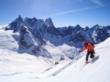
Thrashador Posted March 24, 2004 Share Posted March 24, 2004 Thanks for the tr. That tour is dope! Hopefully y'all had some road sodas stashed near your shuttle rig to alleviate the sting of keylessness. This picture was shot thereabouts a few years ago: Quote Link to comment Share on other sites More sharing options...
jhamaker Posted March 24, 2004 Share Posted March 24, 2004 James in Tacoma wants to climb the Sandy headwall. Two days, w/ skis (wich make great pickets). rsvp to jhamaker(nospam)@operamail.com Quote Link to comment Share on other sites More sharing options...
iain Posted March 24, 2004 Share Posted March 24, 2004 what a nice tour. I remember it getting harder to navigate as Yocum Ridge starts losing a lot of topography down low (I was just out hiking on the spring snow a few years back). looks like you had fun. looks like your snowboarding buddy has chain mail gauntlet gloves on in the ramona falls pic. Quote Link to comment Share on other sites More sharing options...


Recommended Posts
Join the conversation
You can post now and register later. If you have an account, sign in now to post with your account.