


jja
-
Posts
660 -
Joined
-
Last visited
Content Type
Profiles
Forums
Events
Posts posted by jja
-
-
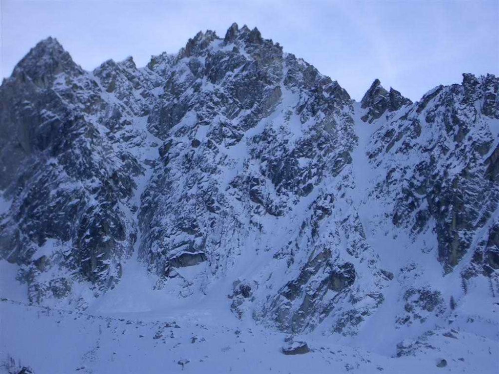
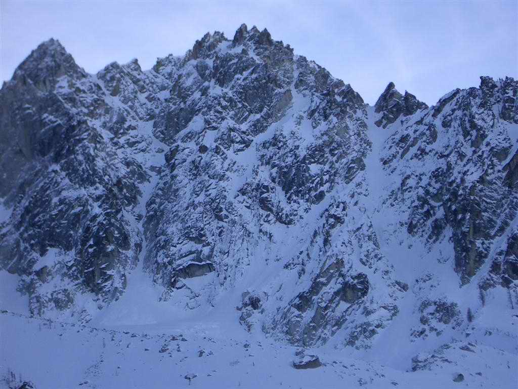
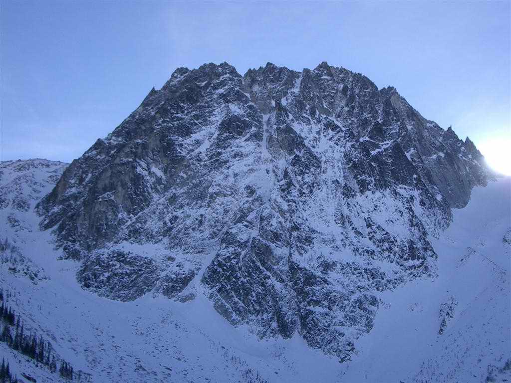
I was up there cause I had nothing to do this weekend, slept half the day on Saturday and was looking to get some exercise yesterday. Left the car at 8:15 road was walkable to about 8mile trailhead, then put on the snowshoes. Trail was distinct all the way to the winter turn off that goes straight up the hill to the mid point of the lake. I missed that turn off (if the winter trail's been established yet). Rather than look around for it or bushwack my own, I continued on the path of least resistance and followed the summer trail around to the south end of the lake (did a little bit of trail breaking here). Hit the lake at 12:30.
I was struck by how cold it was at the lake, maybe low 20's. The lake was frozen, but I'm a wimp so I skirted the edge. No climbing, just out for the views, ate a sandwich, took some pictures and headed home. Great bluebird day!
As far as the snow at the lake, colchuck glacier looked prime for skiing - at least the upper part. Would require some careful navigating down low by the lake to avoid base damage. Snow was a couple of inches of fluff over a breakable crust. Higher elevations had more fluff and less crust. Forgot to bring the binos (doh !) but there was ice here and there.
-
colchuck on 12/21

-
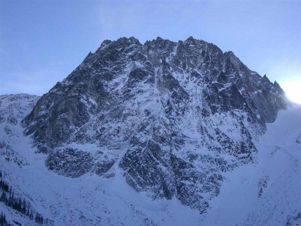
dragontail on 12/21

-
Alas, the ice map isn't mine. (and dru won't sell me one of his 3
 ) In fact the one I was using was a map that a friend had borrowed from a friend. So I can't match your description against it.
But wet lady is on the other side of the road - the same side as loose lady, rambles, tube, etc. The area and climb you describe sound an awful lot like twilight tiers. I've never been there either but it's apparantly a long multi pitch 3+ ish climb to the north of synchro.
-john
-
Tuesday we hiked around in the woods above Cayoosh Creek and found a route that we couldn't identify, but it wasn't in climbing condition.
Hey Nick,
This wouldn't be in the area of "wet lady" would it? We thought about heading up there after seeing it on the ice map, but none of us had heard of it before and didn't want to hike up there (seems about the same elevation as the upper pitch of loose lady) and either not find it or not climb it.
thanks,
-john
-
hey bone,
I've been 3x this year to lill. and every time I went I had know-it-alls tell me it wasn't going to be worth it, nothings in, it's gonna rain, yada, yada, yada. Fuck 'em all and go have fun !!

-
loose lady

-
Doctorb said:
I'm curious about the climbing conditions over the 12/13-12/14 weekend.
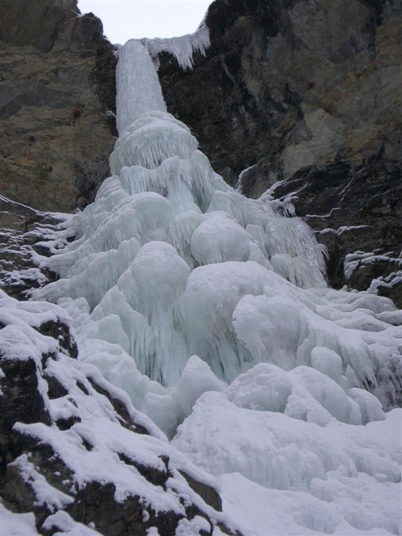
Marble canyon was a little fatter this weekend but basically the same as the pictures I posted last week. The tube is in, but a little thin at the top, loose lady is in with the approach ice being wet and the top pitches with huge mushrooms and poorish pro (didn't do the top out due to darkness and wimpiness). Synchro looked a little fatter and probably doable but we decided against it. I heard - though did not check it out myself - that cherry ice was in. Honeyman is running water down the middle. I don't know anything about bridge river.
-
Wah, wah, wah, it's plenty cold enough.
Local time (Lillooet): December 12, 2003 08:59 PST
UTC time: December 12, 2003 16:59


-
Is twilight tiers to the right of synchro?
-
The approach for RWW is the same as for tres burly, just continue up the gully / drainage for another 45 minutes or so, until the cliffs and trees on the left open up with a steep slope through a cleft in the cliff system (there is a big tree about halfway up the slope). Go to the top of this slope, and only now will you see the route to your right. The whole approach took us about 2hrs, with a couple of mistakes.
I've been told by my partner at the time that you can see RWW from the top of tres burly.
By the way, the crux curtain has a bolted overhanging rock start if you choose. It starts behind the curtain in a little cave thing, then meets the ice about 1/3 of the way up the pitch. Don't know if this has been done yet, but I remember seeing the draws hanging from the roof, and thinking omfg !!
First two pitches are 3/4, then the 5 curtain, then another pitch of 4. The last two pitches weren't in when we were there. I remember gilles had a copy of R+I or climbing with the route and approach beta.
Gilles moved back to france last year, but maybe he remembers more than me if you want more beta.
-
Red Wall Wanderer is an awsome route, 6 pitches if it's all in with the third the giant curtain crux. I got rope gunned up it 3 years ago and would love to go back and do it with a little style this time. For sure the best thing I've been on in Lillooet.
-
Lambone said:
But there are still lots of routes that I have yet to get on....
Need a belay for shreddie and the theft?
-

This is the most popular photo ever on cc.com. Discuss.
-
Dru said:
its a WI6 just right of the rightmost rambles, not the central rambles that everyone calls the righthand

what a horrible picture of carls berg by the way, thats even worse than mike layton's picture of the telephone pole in front of yak peak!
re: rambles. I call the gully with the low angle start and the big honking tree in the middle of the ice, "rambles left". The gully I posted the pics of I call "rambles right", and the gully to the right of that (the one with the long annoying low angle second pitch) "rambles right-right". I suppose left, center, right makes more sense.
re: carl's berg. Horrible pic I know, through car window from the road, but I figured if anyone was interested in how this was shaping up, it's better than nothing.
-
The photo of synchro I posted is the best I have, shot from the car window while in a hurry (didn't want anyone to rear end us while stopped in the middle of the icy road). Fred's right in that there didn't look to be anything I'd call ice below the obvious ice in the picture. But I've never done this route before, so I don't really know what "in" looks like from the road. But I do know that when I was up there two weekends ago with cavey that long rightward diagnal pitch was just a wet streak. It's supposed to be cold all week too, so I suspect lot's of stuff will be coming into shape for next weekend. Synchro is for sure on the winter tick list.
 Fred, the picture I had of you leading shreddie got deleted somehow, so I posted the "excited " picture instead. Seriously, there are beacuoup pictures, I'll burn them all on a cd at full res and send it to you at work, then you can give them to tim too. Thanks for driving again !!
 -
First pitch rambles right

Me on upper pitch rambles right

TimL on upper pitch rambles right

Fred_Rogers getting excited (aka "the ice boner")

Shreddie

Carls Berg

Synchronicity

Icy BC

Deeping Wall

No Deductable

TimL on Pink Cadillac

Me on Dihedral (just before I knock the entire thing down while on tr, he he)

-
Barry, I have no clue. But if you're up there take a look at the ne slab of der toof and tell us what you find.
.. in fact you could set that as an objective and if it's not in, just hike back down the hill and spend the day at cc.com's favorite new crag "the rap wall".
-
Scan it and post an image dru, or is the INFAMOUS LILLOOET ICE MAP as real as the NEW SMITH ROCK GUIDE?
-
glassgowkiss said:
easy mixed routes. hey i just remember. above right hand "Rambles" back in 98 or 99 i did a couple of very cool pitches.
after you finish righ line "Rambles" go up hill for about 20 minutes. there is another cliff with at least 3 lines. there was a very skinny "cigar" on the left side of that cliff. initial 5 m pour over a cave and during fa was maybe 30cm across at the base. "Polish Sausage" WI5 PG, 20m. don't sneaze, might fall off (if you know what i mean). rap off a big block at the top (double sling left in place)
to the right of that line there are another lines (about 20m down the slope). there are several crack systems (good granit, natural pro). there are 2 mixed lines, in a true polish fassion mixed. bring set of cams, kb's, la or two stoppers and short screws. both are about 25m long and are about M4/M5 (depends how much ice). use a tree (sling left) to lower off. have fun!
Hey bob, is this the area that is accessed by climbing a short 2+ pitch then a long annoying low angle ice pitch? If it is, that is where the mixed ice clinic was at last year's ice fest. Or am I thinking of the far "right-right" line?
-
Anybody want to do a long weekend in banff over xmas or new years?
I was thinking either 24 to 29 Dec (leave the afternoon of 23 return evening of 29) or 1 to 5 Jan (leave the afternoon of 31 return evening of 5).
-
The Jan 04 rock and ice has a review of this boot (and several other models).
-
urbanwanker said:
OK, author of original post here, just added another pic file with better close up of the climb. Eventually, I'll figure out how to put these in the body of the post.
here it is:

-
To add to the beta from T-day weekend:
Professor falls is in (not wet at all), we skipped the top pitch since it was dumping and there is a bowl above that pitch, but that looked in too.
Johnson Canyon main upper falls is in if you don't mind either rapping to the base of the climb or tempting fate (and a cold swim) trying to get to the base. The ice that comes over the rock to the right of the falls is just daggers, not even close to touching down.
ATTN: Photographers
in Climber's Board
Posted
Disclaimer: I take suck pictures.
I only use a point and shoot, so this will only work with small cameras. But I've found it's handy to run the lanyard around my neck and then tuck the camera in the chest pocket of my jacket. It keeps the camera warm (important for the batteries esp on digital) and provides for quick one handed access w/o fear of dropping the camera.
For rock climbing when I don't have a jacket on I use a small case I got at rei with a clip on it. I just clip it to my harness. Access here isn't as quick but w/o gloves it's easy enough and I don't worry too much about dropping it.