

DPS
-
Posts
4372 -
Joined
-
Last visited
-
Days Won
24
Content Type
Profiles
Forums
Events
Posts posted by DPS
-
-
(...) I really don't recall any sketchy flakes except for the thin one following the hand traverse directly below the sloping belay ledge with the tree.
DPS are you referring to the 2nd/3rd (depends how you pitch it out) pitch of remorse with that creaky hollow flake below 2 tree ledge? goes left toward the 5.7 pitch up to the ledge?
that is was i was envisioning as well. i don't recall any flakes above on the right traverse pitch, but sure know that horn with all the slings. i think one of mine was welded into that crack for a while.
I was not referring to Remorse, I've never done it. I do not remember any creaky flakes on the entire route, except for the thin flake right at the end of pitch three; the crux, sloping hand crack. The thin flake never seemed creaky, maybe a bit friable though.
I recall two ways to 'approach' the crux sloping hand crack traverse, both of these start at Two Tree Ledge. An easy, blocky, grassy, dihedral, and a vertical hand crack to the climber's right of the dihedral. Right after the sloping hand crack (with a broken off Friend in it for years), there was a short, vertical section that started out as fingers behind a thin flake, depositing one on the sloping ledge with the tree.
The next pitch climbs a low angle face to a steep flaring corner behind a pedestal. The top of the pedestal is the beginning of the 100 meter hand crack, spilt by Library Ledge.
-
Hi Tim,
I tried texting you back, my phone is very difficult to text with. Please call 206-276-8991 or email Daniel-p-smith@hotmail.com
-
I've climbed out of the gulley. It was a single pitch dihedral, about 5.6 on good, blocky rock. I climbed it in double plastic boots.
-
I have a BD Shadow, 45 liter. It has a lot of useable life left, but some cosmetic damage from a snafflehound attack. The damn think also chewed off the sternum strap which I replaced. I am 5'9" and the pack fits me well.
I would let the pack go for $40, of less if you are really need to spend less. I live in Issaquah and am going through medical treatments for a serious illness so I am not very mobile, so I would either need to ship the pack or have it picked up in Issaquah.
Email me if interested Daniel-p-smith@hotmail.com
-
As I recall, there is a vertical, beautiful, hand crack topped by a horn wrapped in miles of webbing that I climbed once to gain the crux hand traverse. Can this be used to avoid the flake that fell off? It was the most sustained, strenuous bit of climbing on the route, but no harder than 5.9.
I've climbed OS six times, I really don't recall any sketchy flakes except for the thin one following the hand traverse directly below the sloping belay ledge with the tree.
-
Are these the flakes following the hand traverse that lead directly the sloping ledge with the tree? Crap, I always climbed those delicately, but I never imagined they would fall off.
-
Rotowall and Non Vertical Smile areas are good suggestions. FWIW, Alex climbed with me and my daughter starting from when she was quite young, around 6 y.o., (she is now 29) so he has a lot of experience climbing with youngsters, not just his own kids.
-
Bruce's Boulder, Barney's Rubble, Mountaineer's Dome, Clamshell Cave, The Hand all within an easy walk from, or next to, the car.
-
The weather has been pretty testy, I've not heard of any reports from Baker yet this year. I think as soon as the weather improves and the snow pack stabilizes you should be good to go.
I climbed it in May or June about 20 years ago (my memory fails me as to the exact date) and the 2-3 steep pitches were bare glacial ice.
I think the route itself stays in shape as long as the glacier approach remains well bridged. As I recall that seems to be the limiting factor.
-
Still looking for opinions on the snowpack and if anyone has a fuel usage calculation.
Yes, there will be a snow pack. It may be higher than normal this year and glaciers may be in better shape than the past few seasons. I suspect that will be the case given the amount of early season snow this year.
During the first two weeks of July there will be lot of running water below 8,000 feet. Bring a filter or Chlorine Dioxide tablets. Once on the glaciers, I would not count on running water, but the snow should have a high water content.
Fuel consumption is really hard to predict. What kind of stove are you using? The new stove systems (JetBoil, MSR Reactor/Windburner) are more efficient than a non stove system. Are you using a liquid fuel stove, like an MSR XKG, or a canister stove? What kind of pot are you using? Steel, aluminum, or titanium? Is it anodized? What color? Will you be using it in a shelter? Do you use a windscreen? What elevation are you camping at? Are you melting snow to just melted or to boiling? Are you cooking things like pasta or using freeze dried add hot water meals? How much coffee do you drink? What about warm drinks in the evening?
I use an MSR Pocket Rocket with a windscreen/heat exchanger I rigged up. I use a black anodized aluminum 1 liter pot. For two people, for a two day climb, I use less than 8oz of fuel, but I fill up all our bottles/bladders with running water before stepping foot on the glacier.
I'm also careful with the stove, I don't run it at maximum output, I insulate the bottom of the canister from the cold ground or snow, and in cold weather I put the canister in a shallow dish and dribble warm water over the canister to improve performance.
Every trip I take I end up with a partially filled 8oz gas canister. I take another full one and use up the previously used one first. I can sometimes get two, two day trips with two climbers out of an 8oz canister.
-
Dan, I want a picture of you with the jacket and scarf!
And a merino wool scarf. Don't forget that!
Rob McDaniel gave me the idea for the scarf. Sure a buff is arguably a better garment, but Gaston Rebuffet never wore a buff. Empirical testing has shown that a clove hitch is the ideal knot for a scarf. I am working on bringing back knickers as well. The trick is finding socks that will work with knickers.
-
Mzamp, don't underestimate the effects an extra 1,000' of elevation may have on you trying to push onto IF for your day 1 camp.
When I climbed the Casaval Ridge on Shasta, my partner and I originally planned on camping at 10k. We ran into a soloist who asked to join our party. He had researched the route extensively and convinced us to camp at 11k, which was a really good idea, except my partner does not acclimate well and ended up becoming very ill. Had we camped at 10k, he would have been fine. The extra 1,000 feet made him too sick to summit the next day.
As well, there's real value to starting your summit day off right with a crap in one of the DC outhouses rather than shitting on the snow at IF and managing the blue bag.To me, the convenience of camping at Muir outweighs any gain from camping an hour farther along the route. It will be much more difficult to dig a platform at IF than at Camp Muir, if you have to dig one at all. Camp Muir is a safer place to camp as well.
-
IMNSHO, stretch woven softshells are perfect for wearing on the bus to work in Seattle. Water resistant, windproof, and look much nicer with your business attire than a hard shell.
I also like them for lift service skiing. Paired with a nice merino wool scarf the look is quite fetching.
I wore a stretch woven softshell climbing once, and never again. In my mind, the original softshell, the Marmot DriClime windshirt, and similar designs by other manufacturers out perform stretch woven softshell jackets in every way.
They are as breathable, as water resistant, but lighter, more packable, and layer better due to their slick nylon shell. I am on my third one and never head into the mountains without it.
My stretch woven softshell sees the mountains only from a chairlift.
-
what is the thought of not carrying avi gear (beacon/shovel/probe)?
Don't need them, don't take them. Any avalanche that occurs will likely kill you. The most dangerous places for avalanches are on the Ingraham Glacer, below the seracs. Don't stop there. The Cleaver itself has seen fatalities when a wet snow avalanche sweeps the team over the nose of the cleaver. Be off the glacier before it gets hot enough to cause wet snow avalanches.
- Wands, do we need them? Isn't the route well marked by the guiding companies?
Don't need them, don't take them. The route is well marked.
- 2 or 3 days? Do most descend all the way to Paradise on summit day or stay in camp for another night?
Most active climbers take 1 or 2 days to do the DC, and descend from the summit to the parking lot on the same day. I think it is very rare for a climber to intentionally spend an extra night at Muir after summiting. After climbing most folks want burgers and beer, a shower, and clean, dry clothes.
If you have 3 days to kill, you would be better off making the approach on day 1, spending day 2 drinking water, relaxing, and acclimatizing at Camp Muir, perhaps making a short day trip to the base of the Cleaver, and then summiting and descending on day 3.
I was planning day 1 to Muir, day 2 Summit with the option of day 3 summit based on weather. So we would have enough food and fuel to spend up to 3 nights on the mountain.I always plan to have enough food to spend an unexpected extra day out, and fuel for two additional days.
- Any other advice or hints to increase our chances of success?
you may find some relevant information in this article:
http://www.summitpost.org/so-you-want-to-climb-mt-rainier/507227
FWIW, I've climbed the DC and Gib Ledges routes a half dozen times and shared the route with only one or two other small climbing parties. It depends upon the time of year. If you are concerned about over crowding, go mid week.
-
I agree with SS. I find that for most steep volcano routes, a semi technical piolet (e.g. Petzl Summit Evo) paired with a 50 cm hammer, (Sum'Tec would be golden) is a very useful combo. On Liberty Ridge or NR Baker, Coleman Headwall on Baker, much of the route is not super steep and having a full length axe beats bending over a short tool. For Ptarmigan Ridge, I would bring a pair of tools. There is a lot more steepness than on Liberty Ridge, for example.
-
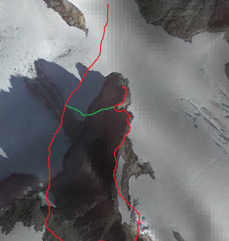
FWIW, I climbed both summit blocks, essentially enchaining the entire Icy Peak massif. (Insert emoticon for sarcasm here). I missed the obvious, water smoothed couloir that clearly had a lot more traffic and fixed anchors than our route of ascent. We approached from Ruth Mt and climbed the SE aspect to the SE summit, down climbed the north ridge to a notch which the obvious, water smoothed couloir topped out at and then to the NW summit block.
The climbing up and down from the SE summit block involved steep, exposed, blocky terrain, perhaps 5.6 at the most. Fun climbing, really. I assumed the NW summit was the true summit, it seemed to have seen much more traffic and I thought it had the summit register, but my memory could be wrong.
Here is a satellite image of Icy Peak's summit tower, borrowed from Google Maps. The red line is our line of ascent, the green line is the obvious couloir I keep harping about and our line of descent. North is toward the top of the photo, Ruth Mountain is out of the frame.
-
Half a lifetime ago when I was Josh's age, my partners and I discussed if it was possible to climb routes like Triple Couloirs car to car with the road closed. Doing these routes with just a day pack seemed so audacious that we tried, and succeeded, and learned a lot about ourselves in the process.
I am continually impressed by Josh's infinite persistence and big successes in the mountains. He reminds me of another young partner, Colin Haley, but without the resources at his disposal.
Good for you Josh. Keep it up, and be safe. These moments will be etched on your very soul and when you are old and unable to climb you will remember when you were a tiger.
-
 1
1
-
-
I'm going to go with the NW.
-
Hi,
First off, I would suggest that this spring may not be the 'best' time to do the traverse. There is a lot of snow, and the traverse goes easily late into the season.
That said, if you don't mind slogging through a lot of wet snow, have at it. I managed to find the most difficult way up the summit block by missing the obvious water smoothed couloir on the front side and climbing around the back, soloing 5.6 terrain on the way.
We descended the standard route making a single, short rappel and down climbing the rest. The correct, easiest route to the highest summit block is the first block you would come to from Ruth Mt. There is a water smoothed couloir that has some fixed slings for rappels that is the easiest way up and leads directly to the true summit.
It would perhaps go at very low 5th class, maybe 5.0-5.2. I think most people solo it and then fix a hand line perhaps for weaker climbers. For a rack, maybe 6-8 nuts, 4 large hexes, 3 small Tri-cams, a few single slings with carabiners, a couple of double slings with lockers. That would be a very big rack for 50 meters of 4th and low 5th class climbing. I think it might be hard to protect as well??
The traverse could be done car to car in a day, assuming conditions are good, but I did it for my 40th birthday and wanted to sleep on the summit. We climbed Ruth, dropped our overnight gear on the summit, traversed to Icy, climbed the summit block, and returned to the summit of Ruth in somewhere around 10ish hours? Sleeping on the summit of Ruth is HIGHLY recommended. The views into the Nooksack Cirque, Nooksack Tower, and the famous Price Glacier are among the best views to effort ratio in the Cascades, IMHO.
-
Ben,
I have had the privilege of mentoring several young climbers over the last few years. I have found it far more rewarding than any of the challenging routes I've climbed.
I've also had some extraordinarily bad experiences when people find out I climb and guided and expected me to guide them up Rainier. These were affluent, entitled people who felt like it was my responsibility to guide them and their bratty kids up Rainier, gratis.
So, I also fully understand and agree with your policy of "I'm going to climb on this day, you can come with me but I can't accommodate your schedule." Nothing wrong with that at all.
-
Here is the next DUMB / Noob question, those who have used the Olympus Mons, what did you do with your climbing pants that would normally go over the outside of your boots? Did you roll them up/under to lay on the boot top and still under the built-in gaiter?
So, I did not have Oly Mons, but had La Sportiva insulated super gaitors over my double plastics. In fact, a number of people thought my boot were Oly Mons.
Any how, I wore MH Chugach Primaloft insulated over pants on summit day, and I wore the pants OVER the top of the super gaiters. I was a little concerned about snagging a crampon, but I was careful, and the pants were not super baggy. I think if I were wearing down pants, which tend to be more lofty than Primaloft, I might tuck them into my gaiters.
-
..... where ya going?
Climbing, duh.

-
I saw a number of climbers with Oly Mons on Denali. They may be warmer than you need, but since you already have them, might as well use them.
The comments about foot hygiene above are key. Buy a small bottle of Gold Bond foot powder and alcohol hand sanitizer from the trial size department at Target. Wash your feet when you roll into camp, (I use snow), use hand sanitizer on them, put on foot powder and a thick pair of wool socks that you only use to sleep and hang around camp in.
I used VBLs, insulated super gaitors, and Scarpa Invernos with Intuition liners. Even in a cold year, in mid May, my feet were never cold.
Thin, merino wool liner socks are gold. After a couple of days the poly versions smell like death. Down booties for wearing around camp are nice.
-
I agree with Alex, Liberty Ridge and Ptarmigan Ridges are typically in sub optimal condition by early July most years.
Perhaps the Mowich Face might be a good choice for that time period. Probably icy, but also might be less exposed to loose rock than LB or PR.
Do you have your heart set on Rainier? Mt Baker is, in my opinion, more enjoyable and very similar to Mt Rainier. More of a wilderness experience, no entrance or climbing fees, less red tape.
North Ridge, Coleman Headwall, and Park Glacier Headwall would all be steep, interesting, and should still be in good shape in July.
Aid climbing gear for sale! a steal (50% off) ~new
in The Yard Sale
Posted
PM sent.