
geosean
-
Posts
220 -
Joined
-
Last visited
-
Days Won
51
Everything posted by geosean
-
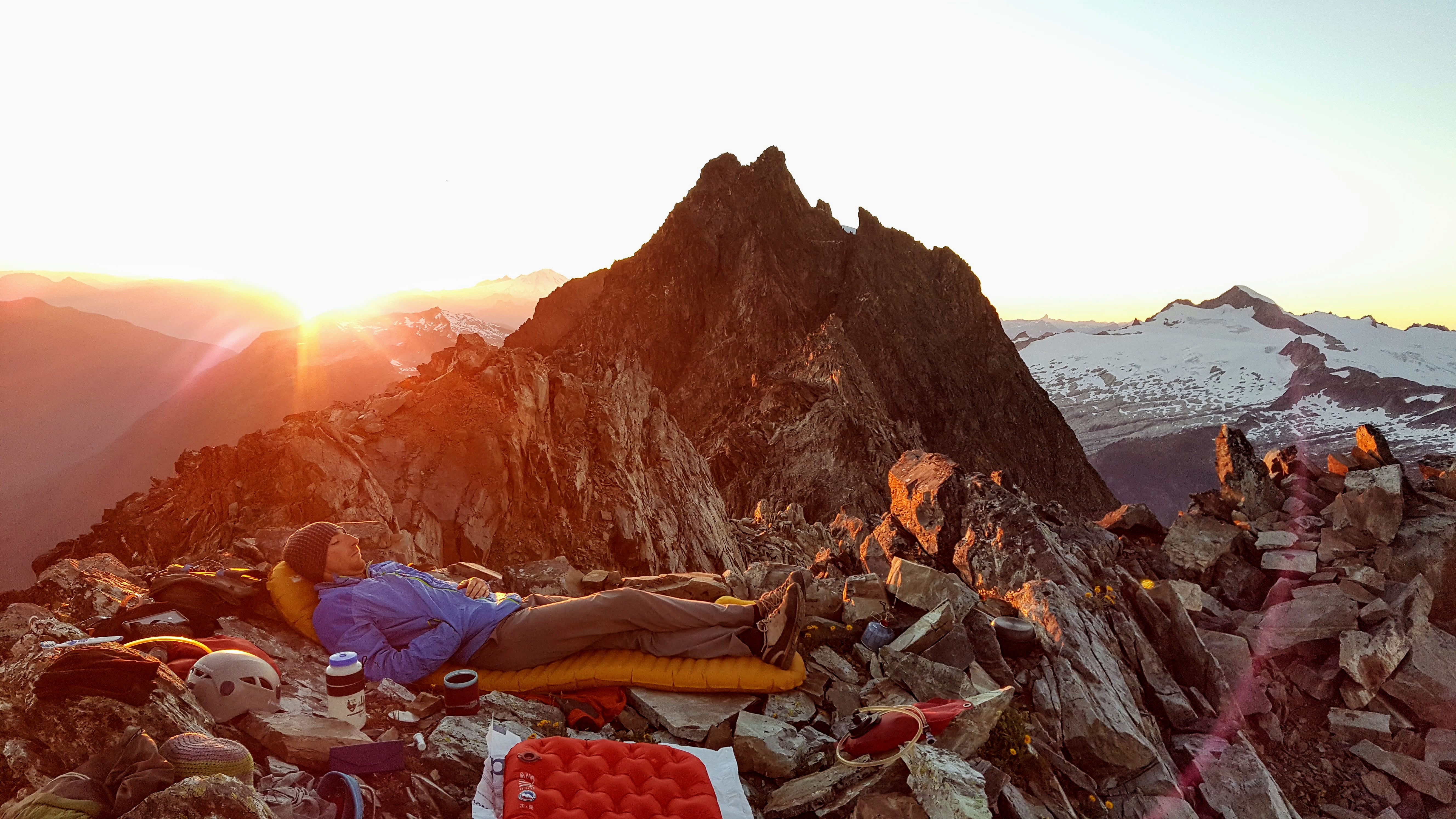
Trip: Mt. Torment - South Ridge Date: 6/25/2017 Trip Report: Me and Tristan climbed Torment by the South Ridge Route on Sunday. We had planned to do the Torment-Forbidden Traverse but the rigors of the approach and climbing with backpacks (despite going pretty light) were too much and we gave it up after just Torment. It was still a good trip in the mountains with great weather and we did climb a big mountain. We started Saturday midday from the Torment Basin "trail". The rangers were of no help with a description or conditions of the route. We went this way due to permits and the fact that the road was closed just beyond so Boston Basin was a lot longer approach than normal. To do it over I still might go from Torment, even if the road was open - the BB trail was actually worse than I remember it being last year. Beckey was actually spot on and only slightly vague with his approach description. When it gets crappy and brushy stay close to the cliffs, I think. We camped at the 6600' saddle on the south ridge of Torment, it took about 6 hours with several long breaks and a fairly moderate pace... plus some off route bush whacking. The next morning we packed up and climbed the south ridge, the notch was an easy walk on snow to reach, actually we skipped some class 4 described in Nelson & Potterfield and just walked right into the first dihedral. We ended up pitching out basically the whole route to the high notch not on purpose but because every time we were ready to simul the rope drag made the leader stop and belay. I recommend no more then 30m of rope between you. Climbing with an overnight backpack on is tough apparently, plus it was hot, so at the high S ridge notch we decided we better not attempt the traverse. We ditched packs and scrambled up the last bit, placing a few pieces. Looking out toward Sahale from the upper notch: Photo of the traverse from the summit: We used Nelson & Potterfield for the route beta and it worked well, plus just follow the tat, there is tons. Please keep your knife handy on the descent and clean some of it. We rapped off and down the gully onto the Taboo Glacier, then hiked down to the upper bivys in BB. There was just one melted out and dry. We had a leisurely evenining and morning, then hoofed it back to the car. I think the BB trail is worse than last year, more deadfall and more brush. The traverse from BB: Close up of Forbidden: Gear Notes: Approach shoes were great, just a little wet on the approach due to snow. 60m rope 7 cams up to #2 set of nuts rap webbing aluminum axe and crampons trekking poles would have been nice on the snowfields and approach Approach Notes: Beckey or Nelson & Potterfield both nailed it, just listen to them and not your brain like we did. Near the top of the forest we went too far left into the trees hoping for relief from brush but it didn't work well. Stay right of all major creeks.
-
I didn't see any snow on the south butt. The only snow we touched on the ridge was on the north side, so I would guess it is all clear. The gullies to approach the buttress looked tricky though, kind of shoulder season stuff: Easy section of the ridge with weather behind (it was dry all day, just cloudy): Also why do some of the pics rotate? It doesn't display that way anywhere else.
-
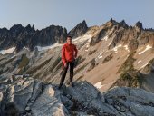
Trip: Cutthroat Peak - West Ridge Date: 6/11/2017 Trip Report: With a somewhat iffy weather forecast we opted for an easier climb. We went into it pretty casually... so much so that we didn't really read any beta before hand. More on that later. We did have cell phone pics of the Beckey description. We didn't know where to cross the creek but found a way. We stayed dry (or at least no one admitted to getting wet). There was a perfect amount of snow for accessing the ridge. We wore boots which was probably good because even with cool temps the snow was pretty wet. The first pitch (Beckey 5.2) was quite scary - very chossy and lots of loose holds. We simuled up it and along the crest to the summit block where we pitched out three short pitches to avoid rope drag. We also put on rock shoes at this point. After lounging on the summit in surprisingly warm and calm weather for quite a while we headed down. We totally botched the descent - if you go the way we went you will understand why people say to rap the S. Buttress. I believe there is a way to make it easy, but we already had all the training weight of extra clothing, so why take the easy way down. What you should do is rap skiers right from the summit chains (I think). We went skiers left and ended up below the south side of the ridge following tat nests for 5 raps (I think) until we hit snow again in the bowl. It would have been fun to down-climb the ridge, but at least we know the way not to go now. It took us 10.5 hours, leisurely with lots of time on top. Gear Notes: Single rack, single rope, axes, rock shoes (not really needed but nice) and boots. Lots more in the packs all day. Approach Notes: Super cruiser snow. S. Buttress gullies are melting out though.
-
Trip: Shuksan (no summit) - NW Couloir Date: 5/27/2017 Trip Report: I climbed the NW Couloir on Shuksan on Saturday. The snow was fantastic for steep climbing, consolidated and crusty. There were some delicate moat crossings, but I could have end run them instead. The top portion, above, below and including the traverse were snice/ice that was front pointing only. This made the traverse quite spicy given the cliff below and the exposure. Me standing at a moat possibly 2/3 of the way up: Top out on the Hanging/Curtis Glacier: It took about 2.5 hours to climb the whole thing, I topped out on the Curtis Glacier at about 10:30. The Curtis was still mostly frozen, only occasional post holing; then I cruised down the White Salmon glissading most of the way. I had wanted to go for the summit but my buddy bailed in the valley due to not feeling well. Met back up with him at the bottom of the White Salmon about 12:30, after a short nap at the WS-Curtis divide bivy site. Gear Notes: Carried a bunch of stuff; used axe, tool, crampons. Approach Notes: Did the traverse, it was pretty decent, mostly snow but not skin-able. I would carry skis from the car to where you break out of the trees on the traverse if I were to go back today.
-
Nice work; and thanks for posting!
-
Thanks for posting, always good to have conditions info!
-
Trip: South Twin Sister - West Ridge Date: 5/21/2017 Trip Report: Climbed the west ridge of the South Twin Sister yesterday with two buddies. It was a great (though very hot) day in the mountains. Light packs and enjoyable climbing. I had been down the west ridge of the south twice, but never up it. We pushed bikes up the road for about 5 miles (except Fred who had to walk out). Then snow forced us to hike the rest of the way. The trail was a bit brushy: We kicked steps up a steep snow slope to access the ridge at about 6100'. At about 6700' the rock gets more difficult and we took the south side snow slope, which proved to be tough in itself - steep wet snow slogging up to near the summit. For the descent we downclimbed the NE face, crossed the glacier to the 5900' notch and descended snow to the basin between the twins and out to the bikes. It was a great day in the hills. Lots of mountaineering challenges - approach, brush, steep snow, gambling on a descent. Loads of fun. This is an interesting time of year to climb in the Sisters range, the snow really adds to the mountaineering challenges versus the easy summer scramble. Gear Notes: Axe, helmet, crampons, bikes. Approach Notes: Bikes to 5 miles, at snow, then booted.
-
Awesome; looks like really fun conditions for the climb. Thanks for posting!
-

[TR] Hubba Hubba Leavenworth - Left flow of Hubba Hubba 3/4/2017
geosean replied to montynet's topic in Alpine Lakes
Thanks for the beta, good to have a conditions check-in! -
Ha, just saw your report on TAY, nice job Pierce, glad you guys had a good trip. Sorry for the skin track back, we thought we were following somebody else's but turned out we were deranged with regret!
-
Trip: Shuksan - White Salmon Glacier Date: 2/25/2017 Trip Report: Me and Thatcher had a sorry attempt on Shuksan via the White Salmon this weekend. Thought I would post for some conditions beta and to hopefully kickstart some conversation... the trip reports have been few and far between on here. We started in the uber-dark from the ski lodge. There was about 4" of excellent powder and not as much crust underneath as I expected. The ski down to the valley bottom went well (a couple of falls but nothing major) with good coverage all the way down. The valley bottom also had good coverage except that all the creeks opened up after the warm and rainy spell. We were making good time up to about 4700' when the clouds we had been watching to the north quite quickly rolled in and it started snowing pretty solidly. We for some reason thought it was here to stay and turned tail like little girls and ran. We did have good skiing down which was part of the reason to flee. By the time we were skinning back up the trees to the ski area the sun was back out and all was blue above. We both agreed that this was probably the worst decision we had ever made in the mountains. It looked like the weather was good long enough to make the summit. Though later in the afternoon the storm did roll in so we wondered how the descent would have been in the whiteout. We finished off the day by skiing up over Table and down the lower part of Little Alaska. I would love to hear how it went for the other group that kept going up; sorry we stopped breaking trail. Gear Notes: Usual... including parking lot beers. Approach Notes: Good coverage, skiing the "clearcut" was better than expected but still not good.
-
Hey, is anyone out there interested in skiing Mt Shuksan this weekend? I'm thinking the White Salmon Glacier should be pretty decent. I'm looking for a single day attempt on Saturday. If we don't make the summit in time at least there should be a whole bunch of skiing. I've done most of the trip up the WSG before, also I have lots of skiing and mountaineering experience. Additionally if anyone has been up there lately I would appreciate some conditions info! Thanks.
-
Trip: Bridal Veil Falls - Various Falls Date: 1/7/2017 Trip Report: Me and a buddy climbed Bridal Veil Falls yesterday near Index. We top roped the main falls twice. The tree anchor is about 210 feet from the base of the falls so bring a really long runner to extend or it is a pain! The ice was wet and lots of water was running behind so we weren't too sure about pro. Main Falls: The climbers left section of the falls looked good too, another group lead it: Then we lead up the upper falls: We hiked up the creek bed finding another WI3 falls above: We completed the hike up to the lake and took the trail out. A great day with lots of ice mileage. Gear Notes: Ice gear. 60m twin ropes. Looong runner useful for TR. Approach Notes: Walked the trail, all booted out.
-
Trip: White Chuck Mountain - NW Route Date: 10/22/2016 Trip Report: Me and a buddy climbed the NW Route (south face of the NW ridge) on White Chuck on Saturday. We had great weather and a good day out. Hit snow line right at the parking lot, there was about 8" on the summit (lots of wind deposited snow in areas though made for some postholing). There was quite a bit of rime on everything on the way up, though a lot of it melted off by the descent. It seemed pretty sketchy as the foliation of the rock is downsloping making for poor footing and no holds or even places to hook your axe. It would be a better route with lots more snow. We made it fine with no gear other than axes. The summit was warm and pretty calm. We were pretty surprised to see two solo guys come up behind us as we sat on the summit. The plan was to go somewhere isolated and little traveled, I think there ended up being 5 parties on the mountain that day including someone on the NW Peak, not sure how they got there with all the rime on the face. Tristan trying to find holds on the down sloping rock. Gear Notes: Ice axe. Approach Notes: Lots of driving on gravel to about 5000' NW of the peak.
-
[TR] Icy Peak - Icy Peak via Ruth Mt. 8/27/2016
geosean replied to aceKronan's topic in North Cascades
Thank you for the praise. I.e. "brisk" and "purist"; I love it. It was a great trip with lots of time in the alpine for the effort. Plus you get to see a real geographic anomaly... the longest 4 mile in the world coming back from Hannegan Pass. -
I'm looking for partners for climbing in general but this time of year mostly looking for alpine rock. Most of my partners are busy with kids, houses, girls. I'm looking at doing: Cutthroat S Buttress Black Peak NE Ridge Triumph NE Ridge Blues Buttress Spontaneity Arete Twin Sisters Green Creek Circuit If you want to do any of these or anything else I'm free weekends (particularly this coming weekend Aug 20-21). PM me and lets work something out. I have lots of experience and would be comfortable leading any of these routes. My climbing objectives are: 1. Come home safe. 2. Have fun. 3. Get to the top.
-
[TR] Depot Creek- Moxes, Custer and Rahm - Standards 7/23/2016
geosean replied to JasonG's topic in North Cascades
Very interested to hear about it. -
[TR] Mount Torment - Torment-Forbidden Traverse (Attempt) 7/19/2016
geosean replied to Marcus Russi's topic in North Cascades
Excellent job, and nice write up as well. The snow traverse is commonly noted to be the crux of the route. Everyone says that the ridge proper looks doable but has anyone actually done it? It would be cool to hear about someone sticking to the rock ridge the entire way, I've not heard of anyone who actually did so. -
Fred Beckey wants to climb this wkend,or get a ri
geosean replied to OlympicMtnBoy's topic in Climbing Partners
Agreed. -
ScaredSilly, thanks for the beta, yeah that snow sliver looks clutch. We were concerned with the unknown of the exit chutes, and later, on the descent we wondered if we could have done them. We thought we had pretty good conditions, but more snow definitely looks better. There seems to be quite a bit less melt at the bivy in your photo; we also had a pretty wide tent. We wondered a bit if a bigger snow year, later in the year with more consolidation would be best. Thus we are blaming global warming for out bail, and everything else.
-
As for continuing up, we were moving really slowly and it was pretty hot; rockfall was a moderate concern, but also we didn't want to be just topping out the route in the late evening and camp at 12,500' on the slopes (avy danger there was a concern). I guess it was mostly a morale issue, now I wish we had pushed on regardless... "who cares if it is dark, you have headlamps right?!" But it is easy to think that way from down here. We rapped from the slings upslope, lots of rope drag, I had to climb back up a bit to free them. It was about 80' I think, but there is an intermediate bench at about 65' that wasn't too bad to downclimb.
-
Here is an annotated photo with the descent route. We had to rap twice, once at the bergschrund at the bottom of the slope in the photo, and once off the left behind the rock prow in the foreground. One could go skiers left once you hit the glacier and avoid the second rap.
-
From our high point looking down at the ridge. Gendarme camp. We camped on the east side just before the gendarme. The ridge from our lower ridge camp just on the edge of the Carbon Glacier after the bail. We descended the ridge on the west side basically straight down the snow slope to the right of the gendarme in the photo. There is a rap point on the rock at the very bottom of the snow slope where you can rap into the bergschrund and walk out.
-
Any help getting photos to post would be appreciated. Ive already loaded them to my gallery, they just wont show up. Incidentally I have found out that if you type with no special characters it seems to work better, unfortunately this makes it look like you just have bad grammar. I think it is some kind of conspiracy of the semi-literate climber.
-
I would say that the bail was only slightly easier than continuing on would have been, though we would have had to go up and over Columbia Crest from the look of the top of the Emmons on the way out. The Emmons didnt look like it would have been easy to find our way onto either, not having gone up it first. Overall it is a very long, tough route, much more so than the grade indicates. The approach along the ridge is an alpine route in itself on most mountains. Only as much as we did would be a long and complicated route on most cascade peaks. We felt good with our decision, I think. Two of the three requirements for a trip were met, we got home safe, we had fun, we didnt make the top but thats third anyway.