
Alisse
-
Posts
456 -
Joined
-
Last visited
-
Days Won
35
Everything posted by Alisse
-
Awesome, Ilia!! Thank you for your detailed and useful trip report!
-

[TR] Colchuck Peak - North Buttress Couloir 6/19/2016
Alisse replied to Jaime's topic in Alpine Lakes
Awesome! Congrats! -
I'll definitely be on rock at that time. I only have one picket, but if you want to borrow it, PM me
-
[TR] Cutthroat | Wine Spires - South Buttress | Paisano/Burgundy 6/7/2016
Alisse replied to aleday's topic in North Cascades
Awesome!! Thanks for the conditions updates! -
Thank you for this update! So you only had to carry your skis for 20 minutes?
-
Trip: Oregon Volcano Fest - Three Fingered Jack, Mount Washington, South Sister Dates: 5/28 - 5/30/2016 Trip Report: Check out a few of the key/useful/interesting photos from the climbs here: https://goo.gl/photos/PMaLJQpKZq5MKNKk7 (Look at the "info" for each photo for details) Over the Memorial Day weekend, a truly fantastic human being named Andy and I had our first-ever OREGON VOLCANO FEST. We climbed Three Fingered Jack, Mount Washington, and the South Sister. I think our times are probably average. Three Fingered Jack -- South Ridge Times: 7:15 am - Left trailhead/car 12:00 pm - At summit 4:30 pm - Back to TH There is already a plethora of beta/information on this route, but I'll add some personal touches: - On the route, remember to stay climber's left (west) and go up the scree-y ledges. There was still some rime ice and patchy snow, but all of the rock that we wanted to be snow-free was indeed clear. - The "crawl" section felt fine to us and we did not protect it. We did see one pin (down low) on the descent. - The shallow chimney crux is pretty short (I placed one cam and slung a horn) and easy; the rock looks absolutely terrible (more terrible than the rest of the route), but I found it to actually be pretty solid. - There are several rap stations with decent-looking webbing. There is one station at the top of the chimney, and there is also a station from the summit block. From the top of the chimney to the actual summit there is a bit of an exposed scramble on very terrible quality rock.. it sketched us out a bit to downclimb. So if you aren't up for that, I'd recommend just rapping from the summit block to the bottom of the chimney. - We saw only one other party, who was approaching as we were on our way out. Mount Washington -- North Ridge Times: 7:30 am - Left trailhead/car 1:30 am - At summit 6:00 pm - Back to TH - The climber's trail is marked very obviously with a giant cairn; right now, discontinuous snow starts a bit before it - There was some steepish/exposed snow we took on the ridge - Rock quality is ridiculously bad. Bring all your good luck charms on this climb. - After the first pitch, we traversed right around a corner and went up that way, which worked for us (I got a couple hand jams!!) - Andy signed the summit register -- first entries of the year, what? - Several rap stations with lots of OK-looking webbing and rings/quicklinks. - The NW bowl looks "AWESOME" for skiing right now, said Andy. - No other parties on route! Just some skiiers. South Sister Times are embarrassing so I'm not publicizing them. My fault, not Andy's! - We opted to carry our skis through the woods instead of trying to skin, I think it was the best choice (snow was icy and discontinuous + there are some steep steps) - Skiing was AWESOME, great snow! All in all, a fantastic holiday weekend!! Gear Notes: For Three Fingered Jack and Mt Washington: Cams- .75, 1, 2 [only used 3 cam placements total] A few larger nuts [never used] 3 single, 3 double slings [most useful] 1x60m twin-half rope [necessary] 1 picket [never used] Crampons, axe Approach Notes: We found that for these three climbs, the snow level was around 5,200'.
-
I think this would be better in the "Climbing News" section -- more people will see it, too, and maybe learn something? I hope the climber is OK and makes a full recovery! I'm still confused how the lowering could have begun and then slack was introduced into the system, the climber must not have been fully weighting the rope at the beginning of being lowered? Maybe it wouldn't have helped, but it seems like it probably would have, to have been using a GriGri...? (I wasn't there and don't entirely understand what happened though, so it's just a guess!)
-
[TR] Vantage - Torre de Plumas 5.7 R A0 2/21/2010
Alisse replied to mountainmatt's topic in Rock Climbing Forum
Thanks for bumping this so I could read this thread -
So many people dying in the mountains over the last couple of months. So sad for the people who loved this most recent victim. I hope we get some details about the accident soon... The most comprehensive article I've read is Methow Valley News article which talks about the knot used. I think the thread discussing it has some really great links about different knots and some testing that a curious person carried out. Prime Rib CC thread In case anyone reading this hasn't heard of it, there is a really great new podcast that is associated with the American Alpine Club (not sure of the exact relationship) with stories from Accidents in North American Mountaineering... each podcast is about a specific climbing accident with analysis of what went wrong, etc. Check it out! The Sharp End podcast The latest episode features a Denali climbing ranger and he has some wise words about speculation and commentary on others' accidents. He says something like, "I'm sure all of us have been in a situation in which we just got lucky. We have likely all been close to being the victim in some way." He also says "Hope is a terrible risk management tool."
-
Awesome!!! Great trip report, as usual. That looks like fun, you guys got on it at a good time
-
NWAC says.. "..High freezing levels, light winds and sunny skies over the next several days will cause natural loose wet avalanches on solar aspects and increase the odds for low likelihood/high consequence problems such as cornice failures." I would definitely NOT want to downclimb the gully and/or rappel under that giant cornice in the temps that we've been having. If I were you, I'd wait for the supreme type 1 fun that will come with colder conditions!
-
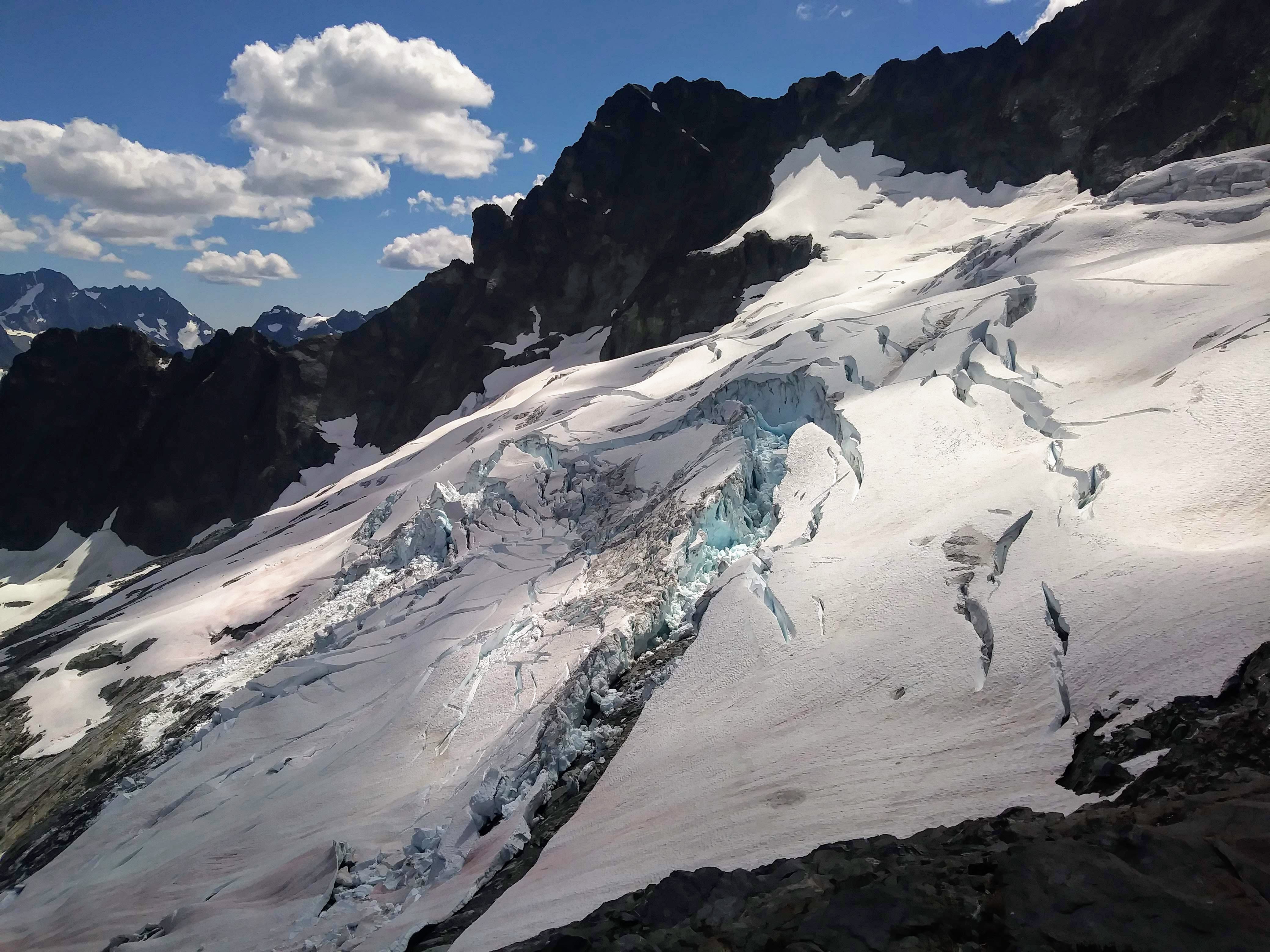
Trip: Chair Peak - NE Buttress Date: 3/19/2016 Trip Report: One of my partners described it thus: "Conditions are fat and relatively mellow (watch out for the cornices)." There was a lot of snow up there and the ice bit was short and chill -- "10 feet of 80-degree max. ice" We left Seattle at 2:30 AM, left the parking lot at 3:50 AM, and had a quick and easy approach on a stomped-out snow trail in balmy conditions (above freezing at that point -- a little disconcerting). We put on snowshoes about a half-hour in and followed snowshoe tracks and tried to stay off the skin tracks. We got up to the basin below the East Face of Chair and after about a half-hour of fighting/fiddling with my crampons (allowing the sun to come up) and then trying to fight through thigh-deep snow in crampons, we re-donned the snowshoes and traversed high below the East Face to reach the base of the first pitch, which we belayed. Snow was good, not super firm but not mushy. AI2-ish with a tiny rock/mixed bit. Windy and spindrifty, made for a nice alpine feel! From the trees at the top of the first pitch, we simulclimbed up and over the little ice step to the false summit, and then up to the true summit (giant cornice! Amazing!) Our beta was to "scramble" down the gully to the rap anchor; it was a downclimb through alternating firmer and wetter snow. Thanks to whoever extended that anchor over/through the cornice (so giant). The downclimb back to the basin was uneventful, we took a little break, and then it was super sunny and postholey on the way out. Trying to descend hills in chunky snow while wearing snowshoes is not fun... but niether is postholing every 3 steps. Car to car time was around 11 hours. IT WAS SO MUCH FUN! Chair Peak! Joe starting the first pitch Ice step! Rappelling over/through the 30' cornice Gear Notes: -- We brought a 1/2 set of stoppers, single cams to #2 camalot, one each 10cm, 13cm, 16cm, and 19cm ice screws, three pickets, two knifeblades and one lost arrow. Alpine draws and some double slings, of course. -- The rack we used consisted of one knifeblade, a few tips and finger sized cams, a few stoppers, one stubby screw, one medium screw, slings for bushes/trees, and the pickets. The pickets were good to have, but the snow was unconsolidated enough that they weren't super useful.
-
Great trip report, Ilia, as usual! Sounds like a beautiful adventure Glad you guys learned some things and only had to sacrifice a few pieces of pro!
-
Nice work, Ilia and Allie! Great TR and pics!!
-
Wanted: Recent trip report of Kautz Glacier route
Alisse replied to Alisse's topic in Mount Rainier NP
Thank you! I should have thought to look on that site... I will next time. Thanks -
Anyone, anyone? Please and thank you! Alisse
-
Thank you!! What did you wear on your feet for the approach up the drainage and how'd it work for you?
-
Hey all, I heard that there was an accident in Mazama over the weekend in which someone fell quite a distance but they are in stable condition. Any other info out there? Thanks in advance! Alisse
-
[TR] Leavenworth - Snow Creek Wall - Outer Space 3/7/2015
Alisse replied to Alisse's topic in Alpine Lakes
Ticks: So, so, so bad. Among four people, I think we've picked off an average of three ticks per person, maybe more. I found a total of five on my scalp throughout the trip, one person found one on her scalp today -- four days after the climb!! I know SCW is famous for them, but cowboy camping at Barney's Rubble probably didn't help.... But really, snow on the route yet ticks abound? Lame. Photos: I have lots but don't know how to post them without first uploading them to some web space hyper cloud?! Temps: of the sending variety! Sunny but cool. It was excellent. -
Trip: Leavenworth - Snow Creek Wall - Outer Space Date: 3/7/2015 Trip Report: Hello! This is my first trip report on Cascade Climbers, so please let me know if it's useful or useless, overly or under-detailed, etc! Four of us of went out Saturday morning to try our hand at Outer Space. I was half of the second party, and I stepped onto the wall at the great hour of...10:30. We decided around 330 to turn around: the walk-off decent off to the south would be icy or not good for us, and we did not have great information on the rappel route over to Pearly Gates. Anyway, we made it to the top of the fourth pitch (5.6). The important information is that there is snow on most of the ledges and on part of the route (notably, the fourth pitch) and snowmelt/running water in several cracks and on some of the slabs. Fun! At the top of the third pitch (5.9), we found a gear anchor that apparently a party sometime before us rappeled off, I guess upon seeing the snow-covered slab at the beginning of pitch 4... (I have most of that anchor, if it's your gear, let me know and I'll return it.) A good day, beautiful weather, and we made it back to the TH by...745, I think. Gear Notes: "Standard rack to 3 inches" I think is what the guidebook says...worked for us. Approach Notes: The trail: compact snow and rather icy in the morning; we had no "traction devices" or trekking poles to assist but we made it just fine. Not too tricky to find where the climber's trail begins off of the main trail. A little fun finding a good route to cross the creek, lots of snow -- some postholing ensued.