Dylan Colon
-
Posts
50 -
Joined
-
Last visited
-
Days Won
3
Everything posted by Dylan Colon
-
With the recent announcement of the record, I now realize that the one other person we saw on the whole mountain both days was Dani Arnold setting a mind-blowing speed record of 1:43 for the classic north face route. We saw him topping out when we were near the summit (clearly he took a slightly different, faster way), and then again on the Grand Dru, doing the traverse that took us an hour and a half in just a few minutes. Knowing it was a historic speed record making us look that bad helps the ego a fair bit.
-
I just typed in "cascadeclimbers.com" and then clicked "Forums" on my work computer, and was treated to a full-screen spread of a bunch of naked women with "who do you want to f**k" in block letters across the top. Another one was blocked by my browser as potentially containing malware. I realize the site needs an income stream to keep the lights on, but I'd rather pay a subscription than deal with that sort of thing, and I'd rather be able to post TRs somewhere other than Facebook. As it is, this makes this site very hard to recommend to anyone but close friends, and I used to do that often.
-
Technique Extreme is still there, though they seem to be a pretty normal gear store these days, selling the usual brands. As for 5.11 at altitude with a big pack, that is bad ass, which is why I ended up doing A1 at altitude with a big pack. The climb was pretty much the definition of type 2 fun, except for the first half of the first day I was suffering and/or anxious pretty much the whole time. Not type 3 though, because a week later I'm still not all better physically, but I can say "yeah that was pretty rad" even if I have no desire to do another climb that big anytime soon.
-
Awesome! Khan Tengri has to be one of the world's most aesthetically pleasing mountains. What's the rock quality like? Is there a lot of loose crap or is it relatively solid?
-
Trip: Les Drus, Chamonix - American Direct/Classic north face finish Trip Date: 08/14/2021 Trip Report: The nearest big peaks to me are those above Chamonix (I am aware of how lucky this makes me), and from the valley floor, none call quite so strongly as the Drus. When I first went to Chamonix in November 2019 for some skiing, I was actually in a pretty bad mental state, tired and depressed. The initial views of Mont Blanc and the Chamonix Aiguilles kind of failed to light my internal fire, but once we reached La Praz, the almost overwhelming view of the Drus rocketing above their surroundings snapped me out of my stupor (I'm doing better these days). The seed was planted. This summer in northwestern Europe has been pretty much the opposite of the summer in the northwestern US, unusually cool and wet. I'm certainly not complaining, but it's made climbing a lot harder to do and I have done a lot fewer pitches of climbing this summer than last, which has not been good for my fitness. At the same time, this is the last summer of my work contract in Geneva, and the knowledge that I would have to make the absolute best of any weather windows that I could get only served to swell my ambitions, admittedly a bit of a dangerous combination. I'd engaged in semi-serious talk with an American I met last summer via Mountain Project named Jared about getting after the Drus via the proudest line we could think of, the American Direct. By late last July, the above factors put me in the psychological position where I was willing to put all of my chips down and try to go as big as possible on the Dru if I could get the point, and I let Jared know. The start of August sucked in the mountains, and I had a few climbing trips in a row get canceled by high winds, snow and avalanche danger, or more high winds. Suddenly, things cleared around August 10, with the promise of a long period of high pressure that might melt some of the snow and ice covering basically all of the rock above 10,500' or so. The long awaited weather window had arrived. I arrived at the Montenvers train station and hotel early afternoon on Friday, August 14. It was super hot, so once Jared met me we decided to wait until a bit before 5PM to start the supposedly roughly 3 hour approach hike to the base of the wall. This left plenty of time to stare at the wall and get intimidated. The route, as planned, starts from basically the lowest part of the face and heads up trending right in the orange-gray rock, until encountering the gigantic light gray rock scar left behind by the collapse of the Bonatti Pillar in huge landslides in 2005 and 2011. Here we would diverge from the original Hemmings and Robbins route via an aid pitch to scoot left onto the shady north face, and then follow the classic 1935 Allain-Leininger north face route to the top. From the base of the rock to the summit is about 3300' of wall. The near-catastrophic retreat of the Mer de Glace has exposed hundreds of feet of blank slabs that were buried under ice just 200 years ago. Luckily, guides have installed ladders to overcome this obstacle. After crossing the Mer de Glace, a series of exposed 4th class scrambles protected by fixed ropes (no ladders on the far side, not enough traffic heading to the Petit Dru to justify them, I suppose, which makes sense) lead to a barely-there climbers trail that traverses a lot of nice meadows. It's kind of like the North Cascades, but with much bigger mountains in the background. Approaching the objective, can you spot the trail? Actually it wasn't too hard to follow, there were cairns and occasional ribbons in trees. Eventually the trail kind of petered out into the sort of loose moraine that we all know and hate, and at the point I made two key fuck ups. First, in the last vegetated area, we stopped to refill our water. This required me to empty my pack in thigh-deep vegetation in order to access my Camelbak. More on that later. Second, Jared and I kind of naturally drifted apart as we picked our was through the shitty moraine mixed with pools of water. The complexity of the terrain meant that we lost visual track of each other, but we weren't concerned because we were pretty experienced with this kind of slog. Eventually I picked up a faint trail and followed it up a long, loose moraine crest to a good rest spot, and waited for Jared, who had been behind me, to catch up. When he failed to appear or answer my calls, a bunch of highly unrealistic but very worrisome scenarios started to creep into my brain, and I dropped my pack and hiked hundreds of feet back down the loose crap. Eventually, I managed phone contact with him and learned that he had opted to contour around the moraine and then climb up the other side of it from where I was. When I described my location, it turned out that my little hike down looking for him had managed to give him a solid 30-40 minute lead on me. Oops. View from the top of the moraine. Finally, we reached the bivouac sites atop the Rognon des Drus, shortly after sunset and nearly an hour later than we'd hoped for. Exhausted and hungry, we started to prepare for dinner. It was then that I discovered, to my horror, that the gas canister I'd been carrying was gone. I can only assume it was lost in the vegetation below the moraines from where I'd refilled my water. This was clearly a pretty bad mistake, and made me really upset and embarrassed. After some thought, we still had running water, and cold food is still edible, so no plans were changed. Dinner was cold, crunchy pasta in a freeze-dried bag meant for boiling water but with snowmelt instead. Oops. Also, I realized that in the chaos of our separation and my abandoning and hiking back to my pack while trying to look for Jared, I'd lost my expensive glacier goggles. Oops. We awoke by 4AM under an astoundingly starry sky and got moving under what I hoped was a fresh start from the previous day's amateurishness on my part. We had vague ambitions of reaching the summit bivouacs but mostly wanted to get high up the wall before the Niche des Drus started dropping big rocks on the start of the route, which is probably the most dangerous part of the route for rockfall. The snow moat at the base of the wall was thankfully minimal, but the start of the route itself was a bit harrowing. It consisted of 5.4ish slabs and grooves with a literal waterfall running down it, enough that water would run down my sleeves as I tried to climb through it. It was also pretty much entirely unprotected save for a single shallow 0.2 X4 placement I found behind a flake, and we were moving together, so a slip by either or us would have been a catastrophe. After this exceptionally rude awakening, we reached a dry ledge with a bolted anchor, changed into rock shoes, and got the first dawn light to see where we were going. We simul-climbed the next 6 pitches of 5.7 to 5.9 in 2 blocks, which felt honestly great and we kept moving along at a good pace. I did notice I was sipping on my hydration hose worrisomely fast, probably a result of my lack of acclimatization (the bottom of the route is at 9000'), but this didn't feel like an enormous problem yet, as we were climbing in the early morning on a west face in the shade. By 8AM we reached the golden rock of the headwall and the climbing quality went from really good to spectacular. This is the first money pitch (pitch 11), the 40m dihedral, which is probably about 5.10d. It is as fun as it looks. Our strategy was to climb with our packs on unless the climbing was hard enough to make it really impractical. For us, that meant the packs were pretty much always on, but we hauled the 40m dihedral, which Jared found to be fairly miserable experience between the weight of the packs and how thin the 6mm tag line was that we used for the task. After that, we stopped hauling. I started slowing down between the increased difficulty of the climbing and mounting fatigue. We largely stopped simul-climbing, and I was also beginning to become acutely aware of my dwindling water supplies, as there was no snow or water available anywhere on the wall, it was just too steep to hold moisture. I also wasn't eating enough because of how dry my mouth was, which further cut into my energy levels. Jared following pitch 14, another nice 5.10 corner. We kept moving upwards with very few breaks (Jared had to coax me to adhere to this) until we reached the very nice jammed block bivy site atop pitch 20 at about 1:30PM, at about the same time that the sun did. As things tend to do when the sun comes out, it got a lot warmer really fast and I finished off my water. I was very dehydrated, so I wasn't able to get much food down, so my energy levels were a bit shit. Grateful to be climbing with a stronger partner, I told Jared he'd have to lead the crux pitches to come, which he was fine with. This is the crux of the route and it's crowning jewel, the so-called 90 meter dihedral. It's a long, smooth-sided finger crack dihedral in very smooth and top-quality granite. After an approach pitch up the start of 5.9+ or so, it gets broken into two long and pumpy pitches of 5.11b or so. Jared led the first pitch with no pack on and then hauled his pack up in a fine effort. To save him some suffering, I kept my pack on as the follower and commenced one of the hardest fights I've done on rock in a long time. A full pitch of fingerlocks, smearing, painful toe jams, and palm presses got me to just a few moves below the anchor when I needed to take. The 2nd pitch, if anything, is even cooler, but probably harder. Hauling again was miserable, so Jared tried to lead with his pack on, which proved very difficult-looking when the climbing turned into 5.11 laybacking off of a finger crack with smears for feet. After quite a few hangs and some pulling on gear, he made the anchor. At this point, I was completely gassed and I basically aided the pitch, standing in slings, pulling on whatever gear I could, the works. I regret this, but it's hard for me to feel too bad about being unable to climb 5.11 granite 23 pitches up with a big overnight pack on. After the 90m dihedral, the original route heads right towards the rockfall zone via a pendulum. Instead, we opted for the "German Rescue Traverse," which follows a bolt ladder to the left over the void towards the junction with the classic north face. Jared on the aid pitch. This one is just as much fun for the follower, and I was sloooow on it. The fixed rope is apparently pretty new, as are a couple of the bolts, since some of the horrifying old bolts that used to comprise the traverse appear to have broken. Reaching the comfortable bivy spot at the end of the traverse was a relief, and we decided to stay there for the night. Luckily there was snow and a bit of dripping water, though without gas it was definitely still a deprived situation. I ended up sleeping with a camelback full of snow in my sleeping bag with me to melt it for the next day, though not before realizing I'd forgotten my wag bag and shamefully pooped on the ledge and then flung it off the cliff into the abyss as far away from the standard north face route as I could manage (I swear that's the first time I've ever done that). Oops. The sunset from the bivy site was divine. My "cozy" little spot. I definitely woke up and checked to make sure I wasn't sliding towards the edge a couple of times in the night. We awoke at 5AM in order to get moving again, I was still pretty tired from the previous day but had grim determination to see it through. Ahhh. Alpine starts. It was extremely cool to get to climb on the historic 1935 route up the north face of the Drus. The face was considerably less chossy than its reputation and appearance from afar had led me to believe, and the rock was generally good. We started by simuling a couple of pitches, then I led the Fissure Martinetti bypass to the original crux, figuring getting to the top by the path of least resistance was challenge enough. We immediately canceled out this energy-saving measure, however, by getting a bit off route, with Jared leading a thin finger crack in a slab that felt like 5.10c or so, but it was hard to tell because it was a bit wet and I stood on a piton to get past the snowy start. Once back on route, we quickly pushed to the upper face via a couple of blocks of simul climbing, with ever expanding views. As we got higher, the rock got wetter and the ledges had more loose rock and snow on them. Near the top of the face, there was a bit of easy chimneying kept interesting by ice in the back and water running down one side. Classic north face stuff, I presume. Never hard enough to be a big problem though. North face ambiance. Yes, I was kicking steps up the snow in my TC Pros towards the end. Eventually we found the fabled hole through the mountain towards the south face, and opted to pass through it to finish up, mostly because climbing in the sun on drier rock again sounded nice. A couple rope lengths and a couple of route finding errors later, and I found myself with no higher to go. The summit of the Petit Dru! I had expected catharsis, but felt mostly mild relief that I could stop going up (at least for a moment). It's hard to relax much on a summit like that with such a long descent ahead. Nonetheless, I scrambled down to pay my respects to the summit Madonna. Can't imagine dragging that thing all the way up there. The next task was to traverse over to the Grand Dru with it's rappel descent. This consisted of a short scramble down followed by a few short, wandery bits of crack climbing up to 5.9 that culminated in a wet squeeze chimney. Entering the chimney, I very briefly considered taking my pack off and committing to the free grovel, but quickly decided that the knotted rope in the back looked more appealing, so an aid pitch it was. Finally, we found ourselves on the summit snowfield of the Grand Dru. Jared on the highest point of the Drus. Summit panorama. Not a bad view at all. Amazing spires all around. Not much can be said about the rappel descents on the south face of the Grand Dru other than that they were long, wet, and tiresome. The rope got hopelessly stuck on the pull after the very first 45m rappel, forcing Jared to lead 2 pitches to get it out of the flake that had eaten it, which definitely soured the mood. Mercifully, there were no more incidents for the next 10 rappels down to the Charpoua Glacier. The glacier was in decent shape, but the snow was incredibly soft and repeated post holing got my socks quite wet. Once we neared its bottom though, we were confronted with a small ice cliff of about 40 degrees that we had to front point down. I'd compare it to a short version of the first pitch of the Kautz. The mountains refused to just let us go easily. Steep wet snow. The small ice cliff we had to downclimb. The two summits of the Drus on the left from once we were finally below the glacier. The Aiguille Verte is on the right. Finally we were able to unrope and a short hike brought us to the Charpoua Hut, where we were able to get a nice dinner. It was clear that the weather was taking a turn for the worse and also that our plans to hike out that day had been thwarted by general slowness. The decision was made to get as low as possible before finding a place to bivy. Sunset from the Charpoua Hut. The next few hours were quite unpleasant. The trail followed easily enough until it got completely dark, and it became clear that my Swiss map app that I had on my phone did not have the right trail positions marked for these very French mountains (go figure). We wasted lots of time, energy, and patience with each other repeatedly losing and refinding the trail, including a big detour following a trail that petered out. It later turned out that the trail we tried to go down had been abandoned because it was exposed to serac fall from the Charpoua Glacier and in the dark we didn't really realize the danger. Oops. Finally, however, we got on the correct trail and things were going pretty well, except for the increasingly frequent but still silent flashes of lightning coming from the west. At about 11:30PM, we figured we were getting pretty close to where the trail descended steeply to the Mer de Glace and not wanting do deal with that, we looked for a place to sleep. Jared quickly found a very inviting-seeming cave with a nice flat floor formed by a large boulder. I crawled in to the back (the ceiling was pretty low) and Jared set up his bivy closer to the entrance. All seemed well. A mere hour later we were brought to attention by several very loud and very close thunderclaps, followed by a quick start to what sounded like an impressive downpour. In the back of the cave, I felt a bit of mist in the air, but Jared gave a cry of alarm. Close to the mouth of the cave, the wind was blowing rain on him, and water running across the roof was dripping on him and to a lesser extent on me. I moved to shove myself farther back to give him room to seek more shelter. Jared, however, sounded increasingly frantic, followed by cries of "there's a hole, there's a hole!" Not understanding, I turned on my light, only to see to my horror that my inflatable groundpad was surrounded by a flood of water between 1 and 2 inches deep, making it basically a life raft in our flooding bivy cave. I grabbed a rock and started digging a trench to drain some of the water out and prevent myself from being overtopped. Jared's situation was much worse. When scooting his ground pad towards me, he had popped it on something underneath him (the "hole"), causing it to rapidly deflate and drop both him and his down sleeping bag into a pool of freezing cold water. Luckily, the rain slowed and stopped as quickly as it began, and we managed to spend the rest of the night partially sharing my sleeping mat (though I must confess I took more than an even share) and huddling for warmth. The water drained away once it was not being replenished. Once their was light at about 5:30, we packed up our things, I silently thanked the weather gods that it wasn't raining, and got ready to move out. I'd been in the back of the cave between Jared and the entrance, so I remarked "at least that little breeze was nice," thankful for the ventilation. Clearly irritated, Jared snapped back that the breeze had kept him up all night shivering, and I remorsefully realized he'd had a much rougher night than I had. Despite that, he again put me to shame by setting a strong hiking pace out that I struggled to match, which is worthy of all respect. The cave as seen the morning after. We slept down and to the right in the slot. The south face of the Drus from the morning wet hike out. There were lots of ladders, both in the morning and all over the trail the previous night while we hiked in the dark. Morning on the Mer de Glace. Almost at the end of our hike out, the clouds parted one last time to give us a final view of the Dru, a source of a great adventure I'll remember for a long time. Writing this TR 5 days after that morning hike out, I can safely say that I'm still pretty tired and sore, and some of my toes are still a bit numb from all the jamming, but despite the low points and many small screw ups, it felt like a good experience worth doing. As of June 2013, the Old Chute route on Mount Hood was probably the most intense alpine climb I'd ever done. It's been wild to progress to a climb like this and I'm definitely interested to find out what the future holds, but I'm pretty sure at this point the remainder of my summer will be dominated by low altitudes and beers in the sun more than north faces and cold bivouacs. Once that bad alpinist memory kicks in though, well, I guess we'll see. Gear Notes: All the alpine stuff Approach Notes: straightforward by alpine standards
-
Great report! Krygyzstan is really an incredible place. I think I speak for everyone here when I say the photos are impressive, and we'd love to see some from the other climbs and other lower down places.
-
I was camping at the base of the Chief when it happened. Loud low metallic sound, thought it was some kind of heavy barge doing something out on the water at the time. Wild stuff. Does anyone have insight into how controversial, if at all, the cable car was among the local community?
-
Nice job. The traverse on N Sister is probably "only" 45-50 degrees, but it sure feels steep when you're contemplating your certain doom should you screw up and slip unroped.
- 4 replies
-
- 1
-

-
- north sister
- south sister
- (and 2 more)
-
http://mountrainierclimbing.blogspot.com/2019/06/west-north-side-conditions-photos.html hmmmm
-
I'm interested and I've done the Kautz. Let's watch the weather? A couple of the more long-range forecasts don't exactly look great for the weekend, but it's a long ways off and that could easily change for the better. For example: https://weather.com/weather/tenday/l/Mount+Rainier+National+Park+WANPSMORA:13:US I hope that's wrong, I'd love to give the route another try. In my experience this time of year storms predicted a long ways out often fail to materialize, so I have some hope.
-
Work is keeping me in town this weekend, but I'd be very interested in any later dates, if you end up postponing. I'm sorry to be inflexible on this. If you are able to go this weekend, have fun, the weather looks pretty good now (jealous)!
-
I'd be interested in the 15-17 dates, but honestly the forecast just doesn't look that great. Starting on the 14th is just too soon to make plans. The national weather service is calling for Sunday and Monday to be mostly cloudy, with a chance of high winds and snow showers later Monday. In light of recent events on that route, that doesn't seem like something I'd want to head up into, and that's probably why you aren't getting replies. If you would be able to wait for a later more stable forecast after that storm moves through, I'd be interesting in talking with you about arranging something.
-
I was planning on climbing Liberty Ridge a few days ago, but descended from Curtis Ridge Monday morning instead of continuing up when the wind picked up that stranded the party that was just rescued yesterday. I posted a TR with a couple of conditions photos. I'd be interested in trying it again, but my previous partner is busy for the rest of the month. Is there anyone interested in heading up there next week if the weather looks good? Alternatively, if there is a party with established plans to head up there, looking for a +1, hit me up. The dates I suggested work well for me, but I'm pretty flexible as long as I have at least a week's notice. -Dylan EDIT: I changed the thread title to remove the suggested dates of Thursday-Saturday next week. I'm actually fairly flexible in this, and didn't want people to not look at the post just based on the title.
-
Climber killed, others injured at Thumb Rock
Dylan Colon replied to JasonG's topic in Climber's Board
According to posts by strangers on facebook they were rescued alive. Hopefully they are not badly frostbitten, and what a relief to hear this outcome. -
Climber killed, others injured at Thumb Rock
Dylan Colon replied to JasonG's topic in Climber's Board
It's rather nauseating contemplating how close I was to being up there, having bailed from Curtis Ridge Camp Monday morning. But for a quirk of my partner's schedule, we very likely would have been on the same itinerary as the stranded party. Rooting hard for both them and the rescuers to get a good outcome. Some of the wind gusts Monday morning were pretty vicious at 7300', I shudder to imagine what they were going through at the top. EDIT: I briefly speculated in this post that we may have seen them as dots high on the ridge Sunday afternoon/evening, but I removed that as possibly irresponsible and impossible to confirm. -
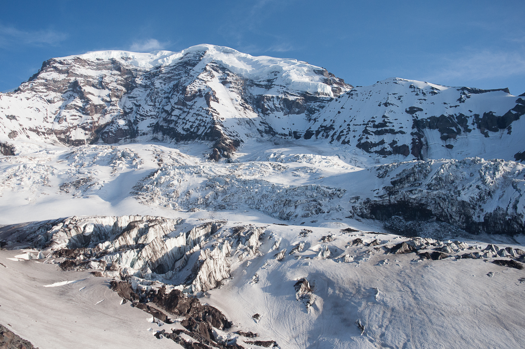
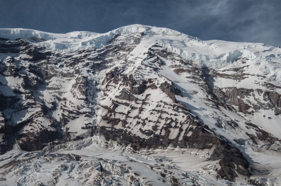
Trip: Mount Rainier - Liberty Ridge Trip Date: 06/03/2019 Trip Report: My friend Matthew and I headed up a couple of days ago to attempt Liberty Ridge, but in the face of high winds decided it just wasn't the time. The recent accident also definitely contributed to our unease. If anyone is interested in conditions, however, here are a couple of photos. The boot pack on the Carbon went through the right of the two obvious corridors through the chaos in the photo, the line seemed very direct from what I could tell from Curtis Ridge towards the west side snowfield below Thumb Rock. A couple of skiers we ran into said the schrund at the top of the Carbon looked very manageable. The ridge itself looks pretty well covered still, with exposed ice near the top of the Black Pyramid, but in what appear to be very manageable quantities. Crossing the Winthrop was mostly trivial, with one narrowish bridge near the far northwest side. View of the Carbon: Close up of the route: Gear Notes: Just standard glacier travel gear for the Winthrop. Approach Notes: Standard approach from White River

-
[TR] MT. HOOD - Devils Kitchen Headwall 03/10/2019
Dylan Colon replied to kadyakerbob's topic in Oregon Cascades
What is the condition of the Pearly Gates right now (or a few days ago, at least)? Enough snow for a rare chance to ski? -
In further retrospect, I think this fiasco might have been avoided if I had a bit more experience in understanding which wind and temperature combinations are able to melt an icy crust. I headed back up there yesterday (with a different partner), and had pretty much the opposite experience. Warm temps, mostly calm winds, and nice soft snow from the crater rim almost all the way down to the car. The temperatues actually surprised me in that they didn't completely liquify the snow, particularly lower down. I think in retrospect I will value my original Mount Saint Helens misadventure as a source of valuable lessons to aid in future judgement calls.
-
I'm wondering if anyone here has been in Mount Rainier National Park since the shutdown began. Assuming the situation in the other Washington out east does not change soon, my understanding from the park website is that while travel on the road above Longmire is prohibited, other travel is not. If someone wanted to access higher elevations, would skinning up the Nisqually drainage past the bridge be viable, or is this unsafe/prohibited terrain? I know people ski to the bridge from above, but I was wondering if anyone had any intel about the situation in the park, either first or second hand. I fully understand that the lack of staff makes everything in the park even more dangerous than is normal this time of year, and I have no plans, just interested in the legalities/possibilities of going there in the next several weeks. Is it even possible to get backcountry camping or even climbing permits with the shutdown?
-
No worries! I just should have been there when you were, because by the time I got there the wind was pretty gnarly. Worth it though. I don't think it changed the outcome, other than the slight chance we would have picked a better route down if there were still other people to talk to. Sounds like it was gross everywhere though.
-
Trip: Mount Saint Helens - Worm Flows/Moniter Ridge Trip Date: 01/14/2019 Trip Report: Mountains are a huge part of my life. I return to them as often as I can, gaining mental clarity, physical fitness, and memories of adventures with friends. I grew up in Minnesota, far from any mountains, and even before I ever climbed one, I felt their call. It’s very hard for me to imagine living anywhere where I cannot go and experience the positive energy that I can only get in mountain environments. This of course means that it’s really a bummer when the mountains remind me that they’d have no compunction whatsoever about killing me in a variety of unpleasant ways. Mount Saint Helens is probably the single mountain I’ve known about for longer in my life than any other, as I’ve been obsessed with volcanoes since before kindergarten (I’m now a geologist studying them for a living). As such, it felt like a pilgrimage to drive up to try to climb and ski it with my friend Reese last Sunday evening, after living in the Pacific Northwest for six and a half years and somehow never making it up there. Promises of clear skies and relatively warm temperatures (freezing levels between 9,000 and 10,000 ft) with low avalanche danger enticed me to propose the trip, and I went to bed Sunday night in the car at the Marble Mountain Snow Park with dreams of thousands of feet of perfect corn snow skiing. Morning promises of a long ski descent. There was plenty of snow at the parking lot, further fueling thoughts of a ski all the way back to the car when we started skinning up at 5:40AM, under a starry sky. We reached tree line right in time to watch the sunrise, making relatively good time. Even at this early stage, however, there were warnings. Reese repeatedly said that she had a sense of foreboding that she couldn’t shake, a kind of dread of the mountain even though she’d been up similar mountains like Mount Hood in the past. Even so, I assumed once the sun came up we’d both feel better, and that seemed to be the case, so we started up the Worm Flows climbing route past fascinating lava formations amidst beautiful views. In retrospect, this dark feeling proved prophetic. Reese just above treeline with Mount Hood in the distance. At the last trees, we stopped for snacks and put on sunscreen and eye protection, and switched from skins to crampons on our boots. The one black mark on the day so far was the wind, which was typically nasty for a Cascade volcano above tree line in the winter. mountain-forecast.com, if I recall, was calling for 20-30 mph winds throughout the day, which was a bummer, but not enough for me to want to not try to take advantage of the otherwise good weather window. The snow slopes around us were covered in ski tracks from the previous day, with one area we passed even possibly qualifying as a bit tracked out, and this got us both excited for a great reward after the long slog up. We saw a dozen or so other climbers and skiers, some going up, and some descending after very early morning summits. Conditions were very icy, but one of the people met told us she’d heard that things at the summit had softened up for good skiing at about 1:00PM the previous day, so we took a relaxed pace and waited for the corn. The climb itself was somewhat boring, with many hours and thousands of feet of uphill slogging, and it passed mostly uneventfully. I had trouble with my crampons at one point, as my old Black Diamond Sabretooths don’t fit my ski boots particularly well, but stopping to adjust and reattach a couple times on the whole climb in safe positions didn’t seem like cause for particular concern. At several points Reese said she was still feeling nervous and very tired, but emphasized that she wanted to continue to the top. Finally, we reached the final ridge about 300-400 ft below the crater rim, and there the topography made the wind, which was coming from the east, bad enough to make walking difficult, with gusts well over 40 mph in my rough estimate, especially with skis on my back. At this point, I’d gotten maybe 100 yards ahead of Reese, but I wasn’t too concerned, as it’s pretty common for me to get well ahead of or behind my climbing partner on these kind of long slogs, so I made a priority of getting to a point where I could turn a corner and reach shelter. Waiting out of the wind for Reese to finish what were afterwards simply referred to as the “wind ridge,” it occurred to me I’d let the gap between us get too large, so I tried to assuage my guilt by spending a few minutes chopping out a nice deluxe ledge for us to sit on and rest. When Reese rounded the corner a few minutes later, she did not come to where I’d stopped to rest and instead beelined straight for the crater rim. She later told me that she had found the wind awful enough to want to head down, but the wind and the distance between us made conversation impossible, and she decided to get to the crater rim as soon as possible. I caught up to her, and we made the final approach to the crater rim together, and the views did not disappoint. Us on the summit. I wanted to hike to the true summit to the west along the crater rim, and take some pictures of the crater, while Reese told me that she felt satisfied reaching the crater rim, so I took off while she found a sheltered spot to eat lunch. View towards the true summit and the massive crater from close to where Reese rested and had lunch during my summit jaunt. Spindrift at the summit. I must say that the views didn’t in the least disappoint, and I walked along the corniced ridge with a deep sense of awe. Another skier who was resting at the crater rim when we got there reported that the summit had been mostly out of the wind, but I found that to be far from the case, and experienced wild spindrift and intense gusts. On the way back, I found a single gap in the cornices which allowed me to peer down towards the steaming lava dome and take a panorama. Gorgeous view down the barrel of the proverbial gun towards Spirit Lake and Mount Rainier through a gap in the summit cornices. It turned out that I’d misjudged the distance to the crater rim, and the round trip there and back with multiple photography stops ended up taking just over a half an hour, so I decided we’d better get down as it was about 2:30PM and we were definitely running behind our intended schedule by about an hour and a half. I got back to Reese, apologized and said I’d skip lunch in order to make up for lost time, and then things started to go very wrong. At this point, there were three problems which would collectively amount to a serious emergency even if we still didn’t recognize it at the time. First, we were now the only two people left on the summit ridge, as the other skiers left a couple of minutes before I got back to the spot where everyone was resting. This made poor route-finding decisions more likely. Second, conditions were nothing like the corn we anticipated and which the numerous tracks on the mountain seemed to promise us. Instead, the stronger than anticipated wind and slightly cooler than anticipated temperatures conspired to serve us with a huge sheet of rime-dotted ice leading down from the summit, which was seriously unappealing to ski, and was going to require much more skill and effort than we’d planned for. Finally, and most seriously, while resting and eating at the summit, Reese realized that she was quite a bit more tired than she had previously realized, and said she felt cold, exhausted, and dubious about her ability to ski down the unexpectedly difficult terrain. One of the last happy memories of the trip (other than the ending), this wonderful view of Mount Adams. Despite that, a pep talk got us clicked into our bindings and on our way down. The ice was unpleasant, but surprisingly held an edge, and I was relieved to see Reese visibly relax and start making nice turns after a shaky start. That would prove to be the last respite of the trip before our final rescue. I figured that if we crossed the top of Monitor Ridge below the “wind ridge” section which had caused so much trouble on the way up, we could avoid the worst of the wind and get on to our planned descent route. Instead, at the lower crossing we encountered perhaps 50 mph winds and a slope which had been blasted down to smooth ice. It would have been very difficult to cross into that headwind without losing control and tumbling down the slope, so we turned back. In retrospect, we should have given up on skiing then and there, and cramponed over the ridge, but skiing, even in the wrong direction, seemed faster, and with the lowering sun, we headed skier’s right. We managed to descend another 700 ft or so when disaster struck. Instead of giving way to sun-softened slopes as we’d hoped, the edgable, textured rime of the upper mountain turned into equally hard stuff which had been thoroughly smoothed out by the previous day’s thaw and that day’s wind. In what would be in my opinion my most grievous error of judgement of the entire day, I kept leading the way down even when I felt that my edges were no longer really gripping the slope. Finally, on a steep section, I got spooked, leaned into the slope, and began a long sliding fall towards a sharp ridge in the snow about 150 feet below. I deliberately rolled so that I would release my ski bindings and hit it sideways, and piled up debris made the impact mercifully soft. I walked away with only a bruise on my thigh. Looking beyond the drift which had caught me, there was a sickening view of hundreds if not thousands of feet of mostly uninterrupted snow slopes, a real slide-for-life kind of situation, and I realized the kind of awful fall I’d narrowly avoided. I shouted a warning to Reese to be careful of the spot where I’d fallen, but she immediately fell upon reaching the same spot, making the same impact with the snow drift. Google Earth view showing our route and the sites of some of our mishaps. Seriously rattled, we decided to stop skiing and switch to cramponing down the mountain after I made a likely dumb suggestion to continue skiing with and ice axe in hand. We’d barely made it 100 yards traversing a steep slope until I found myself sliding again, this time quickly arresting with my axe. I tried to stand up, and was horrified to find myself immediately sliding again, as my crampon had completely fallen off in the first fall, and was merely dangling by a strap which I’d wrapped around one of the boot buckles to keep it out of the way. Immediately arresting that slide, and pissed at myself for allowing myself to get into that situation, I replaced the crampon, only to have it start to come loose after only a few steps. Having to climb down to retreive a runaway crampon would have sucked, to say the least. Examining the boot later, it seems that repeated use with the crampon had damages the plastic where it contacted the steel crampon, making the fit strangely loose and prone to releasing. It’s unclear to me whether the crampon coming loose caused the fall, which seems most likely, or if the wind merely caused me to slip and the crampon ripped loose in the fall. Just as I was devising a more permanent fix to my crampon problem, Reese lost her footing and went a wild, spinning fall, which it was not at all clear she was going to be able to arrest. Finally, she righted herself and arrested after sliding as much as 200 ft, which is one of the most relieving things I’ve ever witnessed. I caught up to her, retrieved the ski poles which we’d both dropped (luckily, nothing slid so far we couldn’t go get it), and we continued down. At this point, however, Reese’s extreme exhaustion combined with a very justifiable fear of the sketchiness of our situation to slow her down to a near crawling pace down the mountain. When we reached an almost flat spot a few hundred feet farther down, we stopped to consider our options. At this point, it was about 4:00PM and we were running out of light. We decided to text a friend in Portland to inform someone of our situation, but to assure them that we were safe for now and did not require rescue. Shortly afterward, Reese convinced me that we should send a follow up suggesting that we were in fact, not safe, and required a rescue (I did not call 911 myself to save phone batteries for what I was beginning to assume might be a long night). Reese also began to be visibly clumsy and started shivering. If nothing else, helpd to settle my doubts that the decision to call for help was justified. Covering the red line took us 11 hours, and we were slowing down. Without rescue, we were definitely going to be in for a rough time. Assuming that help was many hours away, we began very slowly descending. I advocated that we dig a snow cave and eat and take an extened rest while waiting for help to arrive, while Reese was adamant that we not stop moving downhill. Before this could turn into a real argument, however, a rescue helicopter flew overhead, and we waved at them until they circled, clearly noticing us, and then flying off. Moving slightly farther down, we say two other people just a couple of hundred feet below us, and we moved to go meet them. Miraculously for us, they were in the same situation, having just experienced a long sliding fall, coupled with extreme exhaustion, and they had called for rescue, the chopper was for them. A few minutes later, the helicopter managed to drop a couple of members of the Volcano Rescue Team off, who accompanied the four of us a bit farther down to a point where it could land and shuttle us all down to our cars just before it got dark. It brought Reese down first, along with one of the other party, then came back up the mountain for me and the other member of the other party. My first ever helicopter ride reduced what would have been a multi-hour epic to a bouncy jaunt that lasted maybe three minutes. Your friendly neighborhood mountain rescue helicoptor. In retrospect, this misadventure was the product of several errors in judgement. Chief among them was summitting in the first place, dooming us to a complex descent in poor conditions. In my zeal to reach the summit and see into the crater, I ignored a long series of small but clear red flags in the form of Reese’s repeated comments that she was uncomfortable with the entire situation on the way up. We likely would have been ok if the weather had been a bit better, but we didn't collectively have enough in the tank to descend in anything other than ideal conditions. I’m also ashamed of the way that I skied without adequate means to arrest, especially because I could have had my ice axe in hand with little extra trouble. My crampon-related fall actually didn’t scare me nearly as much as I never personally felt like I wasn’t going to be able to arrest once I had the damn axe in my hand. I also didn’t bring a stove or emergency blanket with me, which would have made a night out much more palatable. I am at least happy that I still had a bunch of extra food and water with me still at the point where we were rescued. In any case, we are indebted to my friend in Portland who called rescue on our behalf, to the Volcano Rescue Team, and to the Clark County Sherriff’s office for preventing an epic. Also, there’s probably something wrong with my brain, but I want to go back in better conditions and ski that hill! Gear Notes: Skis, ice axe, crampons. Should have brought my whippet, but only had normal poles. Approach Notes: Easy, well signed approach from Marble Mountain Sno Park.
-
From what I remember from last summer the last time I was there, this includes the lower lot.
-
I'd also like to know about this. My understanding from talking to a Timberline employee is that lots of stuff climbers and skiers do on a regular basis up there is against their rules. For example, I was told that skiers are not allowed to drop down into the Palmer snowfield and the runs below them from above, even in wintertime when the lifts are not running. As for the "no overnight parking" business, I talked to an employee at Mt Bachelor last summer, and was told that the rule is mainly aimed at dirtbag-types who would just live there if allowed, and that they don't really care about people parked there for a single night as long as they are unintrusive and not taking any good spots. I could certainly imagine Timberline similarly trying to keep people from spending a week or more in their parking lot while turning a blind eye to people who roll in in the late evening and are gone again by 10AM the next day after a lap on the hill. That said, rules are rules, and if this behavior is against the rules, resources about climbing Mt. Hood should note that.
-
I agree, I seriously considered doing the deed myself last time I was up there. That's thing's too dangerous to trust anyway, and a total eyesore. This might sound elitist, but I think that if you feel like you need that fixed line you probably shouldn't be there. IMO the only good reason to do that route is as part of a marathon, and if you can get up North Sister, you can get up the N Ridge of South as well, as unpleasant as the climbing there may be.
-
Hi everybody! I'm a graduate student at the University of Oregon, and I'm going to be submitting my Ph.D. this weekend (already defended) and I'd like to celebrate with some mountaineering, particularly before I move away to somewhere much flatter in search of a job. The recent trip reports for the Liberty Ridge look pretty enticing, and I would love to get in on that action. I'm a moderately experienced volcano climber, and I've done the Northwest Right Gully on Hood, the Kautz Glacier (in late season icy conditions), and the Jefferson Park glacier (sans overly rimed summit ridge) without any serious issues. I have all of my own gear, and am comfortable soloing steepe neve, simulclimbing 45 degree alpine ice, and leading WI3. I tend to do reasonably well at altitude (though sea level to 14k always sucks at least some). I have a backcountry ski setup, and could be convinced to bring that, but I my skis are really heavy and I feel a bit of trepidation about dragging them up such a long technical route. I'd prefer a three day itenerary, but I'm flexible and could be convinced to stretch that in either direction within the constraints above. I've noticed the cold front/minor storm scheduled for this weekend, but things look good after that in the extended forecasts. I have family showing up Saturday monring in Portland for graduation, so I need to be off the mountain by then, but I'm free Monday-Friday. I'd prefer a three day itenerary, but I'm flexible and could be convinced to stretch that in either direction within the constraints above. I'm also open to suggestions for something comparable if conditions don't look good on Rainier or if someone has another goal they're looking for partners on. Thanks a lot! -Dylan Colon