

Pete04
-
Posts
64 -
Joined
-
Last visited
Everything posted by Pete04
-
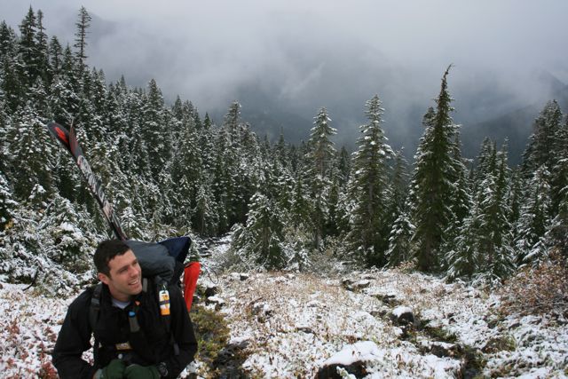
Trip: Half Dome - Snake Dike Date: 11/30/2013 Trip Report: As this was my last weekend to get some mountain adventure for 2013 and possibly my only weekend to get in any ice climbing this winter, I aimed for an Ice Gully ascent of Shasta. On Thanksgiving night forecast winds on Shasta were over 80mph, myself and my partner for the weekend decided to ditch that plan. Looking around at different objectives, we came up with an outline of a plan for North Peak's North Couloir. Knowing that this wasn't yet a solid plan, when I was asked: "What should I bring?" My response was "Everything." With a 4Runner filled with randonee, ice, and alpine gear we headed to Yosemite to see what we could find. Pulling into the Curry Village climbing store our latest plan was stopped by two facts: they didn't sell the ice screws we needed and the highway was closed. Back to the drawing board, we picked up a copy of Yosemite Valley Free Climbs and headed to Swan Slab for a few warmup routes and some inspiration. We decided upon Half Dome's SW Face (Snake Dike). The R-rating was over my head to lead, but my partner insisted he was comfortable on runout pitches and climbed fast so the shortened winter day would be a non-issue. We were on the John Muir Trail pre-dawn but unexpected colds slowed our approach getting us to the base of the climb at 1100 - no big deal. Unfortunately, our over confidence continued and we sat and waited to "give space" to an apparently slow party one pitch above us. We didn't start until about 1200. The first pitch was very slow going as the exposure got to the leader at first. As I would not have lead it at all especially the second pitch, he regained his composure impressively and led a nice climb from there on out at an average pace. Unfortunately, an average pace starting around 1300 on the second pitch puts one on the Class 3 section right at nightfall. We should have done this math and bailed after the second pitch. Again, overconfidence and a desire to get in one noteworthy peak prior to the end of 2013 led us to not think about this and just keeping moving up. I led the last pitch (5.2R) by headlamp as we were unsure of a decent anchor and he was comfortable soloing the pitch if need be and I was not. The summit of Half Dome was fantastic and desolate at night, but with visibility not extending beyond my fading headlight otherwise no-brainer navigational tasks became difficult. Where's the summit? Where are the cables? Where's the route? We made our way down VERY slowly and got on the hiking trail around 2200. Thinking it was all gravy and nothing but a 9mi hike out on a very obvious trail we must have lost focused and were soon bushwacking. Perhaps the Half Dome trail is obvious during the day or with people on it, but at night and with no prior planning it wasn't. We ended up just heading W-SW towards the trailhead thinking we'd run into the trail eventually. Somehow we ended up between Grizzly Peak and Liberty Cap. Out of energy, tired of walking through apparent bear dens, and out of navigational ideas we crashed at 0230 and woke at dawn. My chronic insistence on ALWAYS bringing a down jacket, just in case, was justified. When the sun came up it was obvious where we were, we headed back uphill and hit the trail with still four or so miles left. All in all it was a good trip, a memorable but albeit invisible summit, and many lessons were learned, errr re-inforced. Gear Notes: A half rack was more enough. Not a lot options for pro. Approach Notes: Stay low on the climber's trail when you get to the slab. The trail leads to SE face climbs if you get too high.
-
That's a heckuva week - well done!
-
It worked out pretty well doubling it up. We climbed one pitch with it as a 1/2 rope, but felt much better about it doubled up when pulling it over sharp granite. 60m was too long for all but the rapp off the summit. For the alpine setup, I'm thinking I'll get another 30m twin rope and use that with the 30m twin I already have and keep my single rope for the crag only. Speaking of rope management, to shorten the rope for simul climbing I did a kiwi coil appropriated from the Mountaineer's Glacier Travel book. Any other tricks/ideas of shortening a rope for simuling? This worked well, but a fall would've caught me at the chest and not on the harness; however, I did an overhand knot around the coil so the rope wouldn't just tighten across my chest in a fall (very bad, I imagine) but catch at the coil instead. Still, this doesn't seem as optimal as catching me on the harness.
-
good call - I never thought of folding it over
-
Any opinions on using a 1/2 rope on exposed 4th class and easy (<5.5) 5th class? No expectations to fall. The grade is well within the my partner's and my abilities, but we're not comfortable soloing 5th class and looking for protection on the exposed scrambling. Appreciate any inputs/advice! For reference, I'm headed to Bear Creek Spire (http://www.supertopo.com/rock-climbing/High-Sierra-Bear-Creek-Spire-Northeast-Ridge) this weekend .
-
[TR] Mt. Whitney - Mountaineers Route 5/26/2013
Pete04 replied to Ptown_Climber1's topic in California
Great pic - thanks for the visual! -
[TR] Mt. Whitney - Mountaineers Route 5/26/2013
Pete04 replied to Ptown_Climber1's topic in California
Congrats - looks like you picked a good weather period. If you had gone two weeks earlier there was a lot more snow, which drove me to the "mule trail" as you put it. On my day vis was bad enough that it took UTM coords to find the summit. I only knew I was there by the summit shelter and definitely couldn't tell that it was on the top of the Lower 48. Did you happen to get any pics of Mt. Russell or Mt. Hale? I might head that way in a few weekends. -
Good conditions for the most part. It was slushy in the later afternoon at lower elevations but that's no surprise. I wish we could've started our descent a little earlier around say 1100; that probably would've been great skiing but scrambling with ski boots on and skis on the pack took us longer than expected and we didn't start our descent until the afternoon. Great snow near the top of Avy Gulch and through most of the descent until the runout to the trees under Lake Helen camp. Snow off the summit pyramid was wind-whipped and trash but skiable. View of the summit from the top of Misery Hill: Casaval Ridge to looker's left
-
After being turned back by high winds a month or so ago, my buddy and I re-attacked Shasta this weekend. Casaval Ridge was still well covered and the Catwalk "crux" was still snow filled so it was a non-issue. The true summit was snowless, but skiing was possible from just below the summit (I think my altimeter said 14,040) to the Bunny Flat Trailhead with a small (~100m) area at the bottom of Misery Hill where I had to carry my skis.
-
sweet Sepultera soundtrack! (...and sick line too)
-
thanks - i'm road tripping to Joshua Tree this weekend to take a 2 day class with Joshua Tree Rock Climbing School.
-
I'm looking to take the first (safe) steps into trad. Anyone know of/recommend an instructor or guide service in California? I found one in Joshua Tree but that's a 7.5 hr drive for me from Sac.
-
This pic is me on the ridge (Green Butte) climber's right of Avalanche Gulch. Due to weather, I didn't make it past Thumb Rock, but Avalanche Gulch was pretty straightforward. I'd prefer to ski, but if you're looking for someone to climb with PM me. Depending on the dates, I'll be around.
-
I'll check it out thanks. I've been using mountainproject for beta, so far - not as good as CC though
-
I got the wilderness bug when I moved to Seattle in 2006. Cascade Climbers was (and still is) a great resource for me. I had to do a two year stint on the East Coast but I'm back out in the wild west now and look to get out!! (BC skiing, climbing, mountaineering, backpacking, whatever...) Is there a site comparable to CC for the NorCal region?
-
I'll be watching the weather closely. Maybe we'll have to audible to the North Face. Thanks
-
Inspired by reading and re-reading Lowell Skoog's Cascade Crest route (http://www.alpenglow.org/skiing/cascade-crest/index.html) myself and some friends are trying to link-up a Baker summit (Coleman summit/Park Glacier ski descent) with a Shuksan summit. For Shuksan, I wanted to do a Price Glacier ascent/ski descent, but the trip isn't until June. All the TRs I've seen are either in May or later like August. Does anyone have any experience on what the Price Glacier might look like in June? I realize every year is different between snowfall, spring temps, etc, etc, but I'm just looking for a big picture - "yea that's impossible" or "give it a look".
-
yea - went up there anyway, thanks though. the boot track was not all that obvious compared to Rainier's DC the last time i did it. but yea, it wasn't too difficult. unfortunately the trail dead-ended several times at uncrossable crevasses, so we had to end-run a bunch of crevasses and then come back to the trail. thankfully the bootpack was followable b/c last sunday it was pretty well overcast up there and we only saw one other party moving towards the summit all day. is it always that desolate on Baker or did the weather keep people away?
-
I might head up there this weekend, but haven't been past Heliotrope Ridge before. How well marked (/well tread) is the route up? This time of year I'm guessing there's a pretty good footpath - true?
-
So, did you see the advertisement on the side of the King County Metro buses or is that just a coincidence that they're running bus-length ads for cheap flights to Iceland?
-
[TR] Mt. St. Helens - Worm Flows / Swift Glacier 1/3/2010
Pete04 replied to Frikadeller's topic in Southern WA Cascades
I clearly should've checked this thread before I headed down to MSH this past weekend (1/10). But, since I didn't see it until I was already getting a beer/dinner at the Lone Fir I figured we'd give it a shot anyway. Your lack of snow comment was spot on, but there was even less after a week of rain. Snow from the trailhead to the treeline was spotty at times but almost completely skin-able from the parking lot. After this next week of rain it probably won't be. Sunday was a bluebird day except for a summit cloud which obscured the crater rim. NWAC reports of a 1" crust were spot on. The sun softened it up at lower altitudes. I didn't dig any true pits, but I did a quick armpit test and tried to kick off what I could on small test slopes - all to no avail (thankfully). I did see this old avalanche path - well propogated but not a very deep crown. Closer to the summit was iced over like I haven't seen since I left the East Coast. Crampons were required and I haven't ever been as happy to have my BD Whippet as when it was time figure out how to put on my skis on an icy slope in the whiteout summit cloud. In retrospect, I shouldn't have left my ice axe in the car... but it did make for a good improvised church key the night before. Great descent from sketchy ice at the top to spring corn and then even some slush near the bottom. All and all a fun trip... maybe I'm glad I didn't read your post earlier! Anyway, thanks for the TR. -
cbcbd - awesome info. thanks!
-
Have you skied Katahdin? That is a big tick on my bucket list--ski it and climb the Armadillo route....and perhaps something on Mt. Hamlin. I'm moving back to Bucksport (Orland actually) at the end of March. Hopefully the Whites will be good and stockpiled. Yeah, I'm sure at certain mountains back east 100mm waisted skis turn heads. I can't wait for the lift line comments about why X Wing Labs.....the lift lines are inevitable. I have a fiance learning how to ski. I'm kicking around the idea of doing a New England summit tour this spring. Katahdin, Washington, and Mansfield. Let me know if you've got any info or plans. Need a partner? All I know so far is what I've been able to Google. Why ski East? Because it's there. Seriously though, I grew up skiing New Hampshire. I think learning on it may make you a stronger skier than Utah/Colorado type hero snow, but the terrain is incomparable with the Rockies/Cascades and I'll take freshies in Cascade cement any day over fighting New Yorkers in Vermont for an inch of fresh snow. (Sorry about the NY jab, I'm still burned by the Yankees World Series victory)
-
p.s. if you want to see a pic or two they are under my profile's photos. Apparently, I don't know how to load photos into a TR.
-
Trip: Colchuck area - Date: 6/9/2009 Trip Report: **Disclaimer: I posted a similar post on TAY but I noticed there was a lack of skiing posts regarding this area on cc.com, so decided to post here too** The plan was to ski Cannon Mtn. Due to an apparent lack of snow and no idea how to get there (seriously, where do you get off the trail to head to Cannon? It looks like all cliffs east of Stuart Creek Trail), we called an audible and decided to follow the trail and see where it led us. It led us to what I think was the Colchuck Glacier. I say think b/c I didn't take any GPS readings and my map reading has been known to be off from time to time. Anyway, there's great line from between Colchuck peak and Dragontail Peak. Aasgard Pass only had snow on it's lower half. This is a great day tour for anyone willing to hike a lot and ski a little. But, the views on the ski down are phenomenal! Gear Notes: Hiking boots - it's about 5.2 miles of hiking before you even get to the snow. Hard shell boots for kick stepping (crampons recommended for snowboarders, ppl in hiking boots, etc) Approach Notes: Road 7601 out of Leavenworth. Trail 1599 to 1599.1 around the lake. Then, pick a line any line.