


Rad
-
Posts
2952 -
Joined
-
Days Won
28
Posts posted by Rad
-
-
Remember the KISS acronym? For getting started, lock off and just catch the fall. In 99.9% of situations getting fancy is asking for trouble.
Anything that absorbs energy adds to the dynamic quality of the belay. Dynamic comes from many places:
1 - Rope stretch.
2 - Harness pinching belayer body.
3 - Mass/inertia/movement of belayer.
4 - Rope slip through device.
5 - Knot tightening (both ends).
6 - Minimal stretch of other components (e.g. slings).
-
I personally promise to make fun of anyone who admits doing it.
As Clinton said, it all depends on the definition of "it".
Bring it on!

-
Amazing how little snow is left up there this early.
-
Thanks for the encouragement and thanks to all of you who served as guinea pigs in the process!
 I have a friend that knows of some would be routes in the area now that you are on a roll, let me know if you want a hook up.
We have another crag in the works but are always looking for more opportunities. Why don't you or your friend send me a pm.

-
Go in Mtneer creek and out Teannaway. Car shuttle or get friends to assist in transport. It's a lot of miles on the road but still easier and faster than walking around the mountain or rapping endless choss towers. Also, if you go late enough you can leave axes and crampons at home.
-
I am planning to head up there later this summer. Is this a better route to do than than the NE buttress? We haven't been back in the area before but have a decent amount of alpine rock experience.
Thanks,
Rad
-
The Shakespeare Wall:
Four good climbs in a semi-alpine setting close to the Deception area of Exit 38 provide a nice respite from the crowds below.
We hope you enjoy these climbs. Please help keep the area clean.
Routes are listed from left to right (pictures below):
Macbeth. 5.10a. ***
23m. 8 bolts.
Start at the left end of the obvious slab.
Gain the slab, step across to the upper face at the third bolt, and continue to the top.
This route has high quality moves from the opening mantle all the way to the chains. Avoid the somewhat loose band below the headwall by going high on the slab and stepping across.
FA: 6/06 Rad Roberts, Alex Krawarik, Scott Anderson.
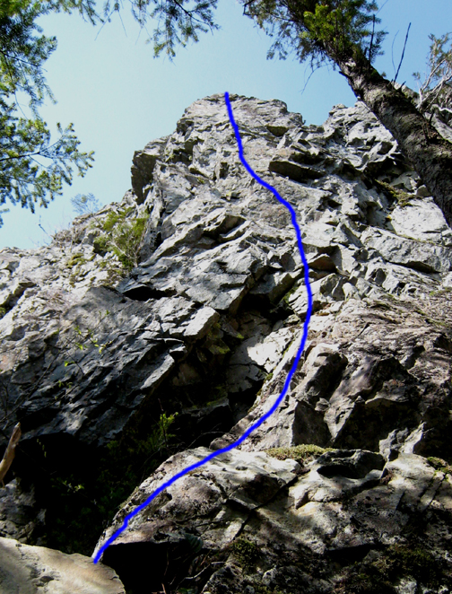
As You Like It. 5.9. **
18 meters. 7 bolts.
Start at the toe of the buttress 50 feet right of Macbeth.
The upper crux has many solutions. All are photogenic.
Bring long runners and stay left to avoid loose rock at mid-height.
FA: 6/06 Alex Krawarik, Scott Anderson, Rad Roberts.
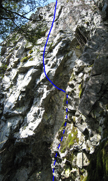
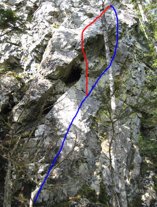
Midsummer Nights Dream. 5.10b. ***
20 meters. 7 bolts.
Start 30 feet right of As You Like It. Follow the rock band under and around a large roof. Fun, sustained moves will get the blood flowing.
FA: 6/06 Rad Roberts, Alex Krawarik, Scott Anderson.
Comedy of Errors. 5.10b. **
20 meters. 4 bolts.
Start on Midsummer, climb over the roof at the chain, and enjoy the crack and face to the Midsummer anchor. If you don’t find the hidden hold you may be in for a Comedy of Errors. Lower to the ground from the anchor and then follow to clean.
FA: 6/06 Scott Anderson, Rad Roberts, Alex Krawarik.
Approach:
Follow directions to the Deception area of X38. Take the trail that starts just past Side Dish (just before a fence), pass Late For Dinner and Just Dessert, and continue uphill for another 7 minutes. From the 6th switchback you can see an unclimbed wall above a talus gully. Keep going for one long switchback and one short one. Split off right at the 8th switchback at a small cairn. You cannot see the Shakespeare wall from this point. If you come out on a ridge overlooking the Hall Creek canyon you have gone too far. After departing the main trail, follow a gradually rising, traversing trail, walk atop a huge fallen log, pass the end of another giant log, then ascend 100 feet to the base of the Shakespeare wall. Macbeth will be the first climb you see.
Despite extensive cleaning, you may encounter some loose rock. Caveat emptor.
If you have any questions or feedback please contact us.
Macbeth - Dashes indicate the slab not visible from this angle.
As You Like It
Blue = Midsummer Nights Dream
Red = Comedy of Errors
Copyright 2007. All rights reserved.
-
"Is the approach supposed to come close to Terror creek?"
Nope. It turns uphill before you ever get to Terror Creek. It was night when I came out from Terror Creek to the trail the other direction, but I'd guess it was somewhere between several hundred yards and half a mile. The best landmark is the small creek mentioned several times above. You can't miss it because it is the only creek with water that crosses the logging road after about half way.
-
"Secondly, what sizes protect the lieback pitch on the genderarme"
3/4, 1, 2 camalots will be fine. Nothing you won't already be carrying. You actually don't need more than about four pieces to that pitch because it's short and there are good rests between stances.
-
For those who thought it was a worthwhile route, it sounds like it might be best to turn around after pitch 15 to avoid choss and anchorless rappelling. Is that about right?
-
Sad news. RIP. I think I'll make sure the pocket glacier is gone before heading up there.
-
"Do you mean the obvious crack about 10-15' right, visible in the photo? Or another one?"
We had only 1 #3 camalot and 1 #2 so I found an alternate to that hand/fist crack, which does look stellar. The crack we did may be the one in the photo or perhaps even another ten feet right (out of the photo). It is perfect hands, sustained but not too hard, and goes over a very small roof mid-height, finishing near the chimney-shaped block on the upper right skyline in that shot. Then you climb about 20 feet or so up a face around to the right (N) to get to the top of the buttress (where we slept, roped in, watching the stars, while slipping off my sleeping pad toward the void - good times!)
The trail is about 100 yards PAST the creekbed that crosses the logging road trail around 4 miles out. Drink and fill your water bottles here as there is none on the steep ascent. As Chuck mentioned, you have to go downhill/downstream a little bit to pick up the trail to the campsite (a flat open area in the forest). Both times I've been there people had laid lots of stones in a line to mark the start of the ascent trail.
-
Nice report. Persistence is key.
I have very fond memories of that route and don't remember it as chossy as you describe. Then again, we were climbing in the mist for most of our trip so I had other concerns. FYI, about 25 feet right of your final splitter crack is another handcrack that may be a bit easier, but still 5.9.
The 'trail' is worn from the converging feet of climbers, so hopefully an efficient path of least resistance will emerge again over time.
Again, good job.
-
Toast,
Post pics if you got em.
R
-
Hope all parties are ok.
That Osman video was probably staged. Experienced climber who likes to catch big air has multiple pieces rip on a gently overhanging route while the camera is rolling...
For some real footage:
-
Your lovely graph clearly supports my points.
Is there a source article/reference that goes with it? Curious.
-
I would not defend Neverland routes, but if you don't like them don't climb them. Period.
Matt and Peter,
I suspect we can all agree that while any bozo can slap bolts willy nilly, rarely do quality routes result from that approach. Creating great routes requires vision and a variety of skills (unless you are just following nature's cracks).
-
Actually, Hook is in Neverland, not Nevermind, and he does say Far side, not Deception.
-
"From Seattle to the Aleutian Islands, by human power: Journey on the Wild Coast will be an unprecedented four-thousand-mile expedition along the northern edge of the Pacific Ocean, through some of the most rugged terrain in the world. No road or trail follows this steep and fragmented coastline. We'll be traveling through forests, between islands, around glaciers, and across the tundra - by foot, packraft, and skis. No one has done this before."
They hope to raise awareness of a number of environmental issues (global warming, clear-cutting, wild salmon habitat loss) through their efforts.
Website with info, pics, and blog of this trip and other trips they've done
Inspired but unable to go yourself? Support them.
Article in the PI:
Wednesday, January 17, 2007
Wild trek set for Seattle couple
In June, they'll begin a 4,000-mile journey, hiking, rafting and skiing from here to Alaska's Aleutian Islands
By COLIN McDONALD
P-I REPORTER
It's important to test gear and be prepared, Erin McKittrick says -- moments before capsizing her 4-foot inflatable raft on Lake Union.
She is wearing a life jacket made from an old sleeping pad and an assortment of clothing that will not keep her dry or warm once she is in the water. The air temperature is below freezing. With a shrug of her shoulders, she flops over the side.
Dan DeLong / P-I
Bretwood "Hig" Higman and Erin McKittrick plan to leave their Seattle house and walk, float and ski to the Aleutian Islands in Alaska. In the chilly waters of Lake Union, the couple were testing the lightweight rafts they will use to cross the fjords, bays and rivers in the journey.
"Cold water is probably the thing we are best at dealing with," said McKittrick's husband, Bretwood "Hig" Higman.
In June, the couple will start a 4,000-mile hiking, rafting and skiing trip that they hope will take them from their rental home in the University District to the north side of Unimak Island, the first of the Aleutian chain in Alaska. Using topographic maps and compasses, they will navigate an area with no roads or trails. They will carry 50-pound packs, average 17 miles a day and follow the edge of the Pacific across some of the wettest, highest and most bear-infested mountain ranges of North America.
"It's going to be a blast," McKittrick said.
They plan to finish by March 2008.
McKittrick, 26, has a master's in microbiology from the University of Washington, and Higman, 30, is planning to finish his Ph.D. in geology in June. They support themselves with $16,000 that Higman earns annually from his research and by selling jewelry that McKittrick makes.
Married in 2003, they met as undergrads at Carleton College in Minnesota.
Back then, neither was into long-distance, cross-country hikes, but on their first trip together during spring break in 1999, they went to Mexico where Higman proposed a three-day walk -- without maps or trails -- across part of the Yucatan Peninsula.
"I just said it to put it out there," Higman said. "And she said 'Sounds like fun.' "
That trip was followed by longer trips across Higman's native Alaska, where they have now logged nearly 3,000 miles. They hiked across the Brooks Range and the Arctic National Wildlife Refuge on their honeymoon.
The couple readily admits they are a bit odd, but maintain they are not crazy or taking unacceptable risks. This could be done by anybody, they say.
"What I equate us more with are the old-school explorers." McKittrick said.
As safety precautions, they may use tracking devices so friends and family can follow their progress and possibly an emergency beacon.
They also plan to document their trip with notepad and camera, then post findings on their Web site at aktrekking.com.
"I think the really hard part of the trip will not be the physical, but the physiological," said Roman Dial, a friend of the couple and a well-known Alaskan adventurer. "The big challenge is if they can do this for nine months. After a couple months it can be very hard to answer yourself, 'Why am I here again?' "
Dan DeLong / P-I
Erin McKittrick
Dial met McKittrick and Higman when the two competed in the Alaska Mountain Wilderness Classic, a cross-country, multiday, human-powered race that Dial has organized for the past two decades.
"I think these two really have the experience and drive to pull this off," Dial said. "I think they have the confidence and innovative spirit to deal with it."
Higman and McKittrick can't see getting bored or questioning their trip. For them, it's not so much a beginning and an end but a change in lifestyle for nine months.
"Sure, there will be bad days," McKittrick said. "But then you get to a really cool spot someplace and the sun comes out."
The couple is paying for the trip with a combination of their savings, donations from family members and gear sponsorships. To save money, and travel with equipment that's both lightweight and durable, they make their own backpacks, rain jackets, fleece garments and dry bags. They usually are forced to alter their store-bought gear, anyway, because it rarely holds up through the daily wear and tear of their treks.
After reaching Unimak Island, the plan is to either hitch a ride on a fishing boat or hire a seaplane to take them back to Anchorage.
"And if my life is going perfect, I will have a job in Anchorage starting in March," Higman said.
But after crossing the mile-wide channel between the Bering Sea and North Pacific to reach the mostly ice-covered Unimak Island -- and before settling down -- McKittrick has scheduled time to explore the island.
"It just looked so cool with the volcanoes on it," she said. "Why not hike around it?"
-
My answer also would not change: first ascentionist has final say and is to be lauded for soliciting the opinion of the community before making a decision or taking action.
-
You put up the route so you should be allowed to make the call.
Icicle bolting practices are all over the map, and both your original route and a proposed better-protected route would be within the scope of styles in the area. This also suggests you should be justified in whatever you choose.
How long until Raindawg chimes in???
-
S Face Ingalls?
A hike, alpine scenery, views of Stuart, easy rock. Good combo for newbies, just ask the Mounties...
Must confess I've not been on the route myself.
-
So did you do one of those finishes Blake?
HoC has pretty straightforward jams. I thought the upper part of P3 of GM, as mentioned by MattP, was harder.
What seems inconsistent is P2 of GM. It's way easier than all three of the sections of P3 discussed. It's like a fun Gunks 5.8.
BTW, can one TR the 10+/11a face route right of HoC from the ledge in the middle of HoC? That looks fun.
Finally, has anyone actually climbed the 10c direct start slab variation below the 5.8 pitch of GM. THAT IS HARD!
-
Icicle creek has lots of great spots.
Got $$$?
If no: Past Rock Island (see campground map provided at Ranger station), on either road fork, there are some really sweet free spots with no amenities, great river access, and views. Excellent semi-alpine ambience abounds, and at almost 3000ft these sites shouldn't be too hot.
If yes: There are a half dozen or so well-maintained campgrounds sprinkled up the canyon (8 mile to Rock Island) with water, crapper, trashbin, and views.
I was with my toilet-training toddlers on our first camping outing together last night so we shelled out $13 for the convenience of a Rock Island site. No ticks or goats were seen! I guess they couldn't afford the fee.
[TR] Gunsight Peaks Traverse - "Gunrunner" IV 5.10
in North Cascades
Posted
Nice work gents.