


summitseeker
-
Posts
129 -
Joined
-
Last visited
Everything posted by summitseeker
-
Not really a climbing report, since I didn't actually summit anything. But, I figured folks might be interested in conditions in the Enchantments. It's accessible, no permits are required, and the rock is largely free of snow on south faces! Check out my post at: http://www.summitroutes.com/cgi-local/ya...89880;start=0#0
-
Summit Routes: Washington's 100 Highest Peaks
summitseeker replied to summitseeker's topic in Author Request Forum
The American Alpine Club reviewed the guide in the Winter 2005 issue of the "American Alpine News." They said that the guidebook contains "enticing gems in out of the way places that are not covered in the bevy of existing Washington climbing guidebooks." The entire review can be read at http://www.summitroutes.com/aac_review.html -
Summit Routes: Washington's 100 Highest Peaks
summitseeker replied to summitseeker's topic in Author Request Forum
Technically, most people seem to agree that the SE Mox (Twin Spire) in the Chilliwack Range is the most difficult of the 100 highest. It has a mid-fifth route with loose rock and is seldom-climbed, so there is some exciting route finding. It also has a pretty strenuous approach, a good chunk of which is cross-country. So, overall it's probably the most difficult. (Keeping in mind that the focus of the book is the easiest routes to the summits.) -
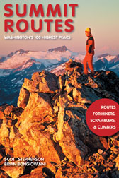
Scott Stephenson and Brian Bongiovanni would like to announce the release of their new guidebook for the 100 highest peaks in Washington by the easiest routes (400 ft prominence). Routes from hikes, to scrambles, to technical climbs, but mostly scrambles. It is now available online and will also be in the local REIs and the Mountaineers Bookstore by late next week. Highlights of the Guide: * Focused on hikes and scrambles over technical climbs * Over 100 quality photos, most with route overlays * Thirty trips ranging from 1 to 6 days in duration * Recommended itinerary for each trip that includes daily elevation gains, mileages, and times to camp and summit * Appendix of trips and peaks organized by difficulty and duration to help you quickly choose an appropriate objective * Detailed driving directions to the trailhead * Recommended climbing season * Recommended maps for the climbs If you're interested, more information on the guide can be found at http://summitroutes.com, including where you can currently buy it. Hope to see some of you out there on these peaks! --Scott Stephenson
-
Azurite Peak and Mount Ballard Beta Requested
summitseeker replied to summitseeker's topic in North Cascades
Thanks Superman. That's very helpful information. I appreciate it. Let me know when you get that info on Devore/Tupshin/Flora. Really interested in what you can find out! -
I am looking for route information for climbing Azurite Peak from Azurite Pass and Mount Ballard via the west slopes. I have read the Beckey description for both, but would appreciate any information from people who have climbed these using these routes. Thanks!
-
I am looking for route information for climbing Storm King from the south. I have read the Beckey description, but would appreciate any information from people who have climbed it using this route. Thanks!
-
Devore Peak, Tupshin Peak and Flora Mtn. Routes
summitseeker replied to summitseeker's topic in Climber's Board
Thanks Blake and Klenke. It's awesome to hear from you both! I've spoken to someone who said that Flora Mountain and Tupshin (via the East Face) are scrambles, Flora being primarily a long scree slog and the Tupshin being not particularly difficult (class 3). He said to definitely take a rope along for Devore, as the 4th class step near the summit is challenging and exposed. However, he did them both ages ago, so I am a bit leery of his information, particularly with regards to Tupshin. And again, not very detailed. Yes, Klenke, I agree with you. Beckey's information has got to be second hand. I too am hoping to head up there this summer to climb these peaks. Just seeing the pictures you posted links to is very helpful, as it's the first time I have actually seen these peaks. Thanks. It's probably going to be a recon. trip, which is absolutely fine -- plenty of adventure to be had. Perhaps we'll hear from some other folks that are also pursuing these summits or who have climbed them themselves. -
I am hoping for some good route information for Devore Peak, Tupshin Peak and Flora Mtn. from someone out there who has climbed these. One of you crazies into the 100 Highest could probably help me out. There is a bit of information in the Beckey, but it's not very detailed. I am looking for easy routes over hard (scrambles over technical climbs). So, that's probably the Southeast Ridge on Devore, the Southwest Route on Flora and the East Face on Tupshin. Let me know if you suggest otherwise. Thanks!
-
yes, i gotta agree that "freshies" is a dumb word. it's decidedly un-alpine, making me think of air fresheners, morning ablutions -- hell, anything else but new snow! it's always been called powder, or if you prefer, "pow pow", but for God's sake not "freshies". [ 01-02-2002: Message edited by: summitseeker ]
-
Yes, I second Freeman's point on the ava hazard. My partner and I climbed a gully and flow to the far left. This meant we had to ascend and traverse (rightward) across all the chutes above the climbs. They are all quite steep (for those of you who haven't walked off before) and have a lot of snow in them. The name "the funnel" is appropo, since they will do that to snow from hundreds of feet above. Bottom line: be *very* careful.
-
Apologies... I know there is a post here that has some info. on this, but I can't find it and need to get back to work, so here's my report. We climbed there on New Year's Day. Another party was on the central flow, so we were relegated to lesser flows. The central flow looks fairly in, although I wouldn't say it's fat. The other flows were pretty thin IMHO -- they can go, depending on your level of comfort. I had to back off one via a long traverse as I simply ran out of ice. What followed was an exciting traverse over mixed terrain on ice an inch or so thick back into an easier snow filled couloir. Slow going, but it holds if you take your time. Even some excavation and an adze jam in a particularly thin area... Anyway, take some rock pro and short screws, else you'll be free soloing everything. :]
-
Thanks Matt. That's a great report. Great timing for me, as I am thinking of heading up there this weekend to climb it. Great to know what you found.
-
Great news! Thanks for the post. Will be down that way later this month to do Leuthold's. Looking forward to it.
-
Anyone heading up there soon? If the weather holds, I may give it a try on 1/1.
-
yeah, the volcanic neck did look cool. have to go back and do that one in the future. bet it was a nice place to camp.
-
Took advantage of the great weather last Saturday to do this four peak scramble traverse in Teanaway. My partner had done pieces of it before but had never linked all four. I hadn't done any of them, so it was a new adventure for both of us. It's an amazing ridge, probably 2-3 miles of moderate scrambling all above 6,000 feet. Earl is the tallest peak, around 7,050 feet and the others are in the mid to high 6s, I believe. Throughout the scramble you're looking directly at the south side of the Stuart Range, so the views are incredible. Stuart, Colchuck, McClellan's, Dragontail, etc. All were covered in a coating of pristine white snow. We didn't see a single person the entire day, and only a few footprints on the summit of Judy, for that matter. Parked at the Beverly Turnpike trailhead and walked up the trail until just before the intersection with the Bean Creek trail where we turned right and headed straight up the ridge off trail. It was steep and we gained elevation quickly. About 1,000 feet up we hit the snowline and we broke trail from then on. Initially it was a foot or so deep, but the higher we got, the deeper it got. Some parts were complete wading, with 2+ ft. of snow. Sometimes snowshoes would have been handy, but most of the time just dead weight since there is a lot of scrambling involved. Topped out on the summit of Earl and the ridge fun began. Over 1 mile separates Earl from Bean and all of it follows the ridge. Easy going and beautiful, with newly forming cornices and all the signs that winter is coming. The views of Stuart et. al. were inspiring. We climbed a mixed gully with some 4th class moves to get to the summit of Bean. On the summit of Bean, we looked at the crux of the route: the 1/2 mile traverse from Bean to Judy. It's a fairly rugged ridge, with a handful of gendarmes and a good chunk of 3rd class rock, much of it covered with snow. Our goal was to stay on the ridge as much as possible. What followed was an exciting experience. We scrambled over a lot of wet, 3rd class rock, wallowed up and down snow filled couloirs where we fell waist deep into plenty of hidden moats, scrambled along the icy, exposed ridge crest, and just generally felt way French. It was an amazing environment, and we were laughing with glee and the ridiculousness of our goal. 1/2 way along the ridge the climbing eased and we were able to walk to the summit of Judy. From Judy, the traverse to Mary is short and without technical difficulty. About the same difficulty as the section from Earl to Bean and equally scenic. Rainier and Adams to the South to guide you, the peaks of Snoqualmie Pass to the West. Fantastic. From the summit of Mary, it was an easy (but deep snow) descent east into the basin, followed by a southwards walk along the contour to pick up the Bean Creek Trail and back to the trailhead. We arrived 10 minutes before dusk, making it a full day. Approx. 8.5 hours and over 4,500 ft., much of it breaking trail. This is one awesome traverse, and not very technically hard. I definitely recommend it for those looking for adventure, solitude, and incredible views. Enjoy! [ 11-07-2001: Message edited by: summitseeker ]
-
Ouray is in Southwestern Colorado, near the town of Telluride. It's an absolutely beautiful place, with outdoor geothermal pools, incredible scenery, easy access from the airport (Montrose or Telluride), good restaurants, quiet atmosphere. In addition to being a great place to learn to ice climb (bolted TR anchors on many climbs and good trees), there is also some great multi-pitch, moderate to difficult, backcountry ice all through the area. Definitely give it a visit some time. [ 10-26-2001: Message edited by: summitseeker ]
-
Pope has some good comments -- weight being one of them. I get around this by owning lots of ropes and using the right rope(s) for the right circumstances. What I was aiming for in my post was a suggestion for a good, all around rope that will treat you well for a variety of situations. More bang for your buck, I guess. A 60m x 9.8mm dry rope will work well for cragging (lead and TR), get you up Devil's Tower (and other >50m pitches), do in a pinch for glacier travel, etc. It's an all-around good compromise, IMHO. And as far as being a brand whore, I like Mammut. [ 10-26-2001: Message edited by: summitseeker ] [ 10-26-2001: Message edited by: summitseeker ]
-
I assume you already have the Secor book? Just thought I'd mention it. Here's a link to it on Amazon.com just in case: http://www.amazon.com/exec/obidos/ASIN/0898867983/qid=1004114597/sr=8-1/ref=sr_8_3_1/002-7509167-8129614
-
From what I hear, there is now a membership fee... think it's around $30 or so, but can't remember exactly. Not sure if it's mandatory. Apparently, they are going to use the funds for upkeep of the park. I do know that only one climber in the party "needs" to be a member. Seems like a good idea to me. [ 10-26-2001: Message edited by: summitseeker ]
-
Anyone know when the season starts? Would there be stuff in say mid-November?
-
I suggest a 60m dry rope, 9.8mm (more length, less weight per unit length). Dry is definitely the way to go -- even if you're not going to be climbing ice or on glaciers -- because ropes do get wet. Keep in mind that a wet rope loses a lot of strength, so a dry rope is *always* safer. It's worth the extra money, IMHO.
-
A little while back someone posted a rumor they heard that the ice park might not be open this year because of "the drought". Well, I emailed the folks from the ice park, and here is what they had to say. It's awesome news! ---- Not true...the park is actually up and running as we speak. We were able to completely replace all of our old plumbing with new material and tapped into a different water source. This new source is up higher, giving us more water pressure, and allowing us to run water about 3/4 ml farther up river to the south. We should be able to create at least 30 - 40 more climbs. many of these climbs will be moderate but there should be some WI5's $ 6's throughout the area. With this new system we will be able to turn off the water during the day or during warmer tempatures so that we are not deteoriating the climbs and allowing us to maintain quality ice climbs that are not hacked out. So... we hope to see you in Feb. with ice that doesn't appear to be beaten up and your favorite climbs appear as they do when they first come in.
-
That must have been a really cool hike! Great idea. I was walking around the neighborhood thinking how awesome the storm must feel in the mountains. Glad someone was enjoying it.