


mattp
-
Posts
12061 -
Joined
-
Last visited
Content Type
Profiles
Forums
Events
Everything posted by mattp
-
Mr. Fleb, in the slot:

-
Eddie, on some firm snow:

-
Fleb, enjoying life:

-
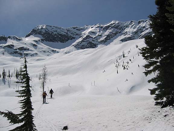
Here's the basin below the Lyell Glacer (photo by Fleb):
-
Ingalls is a good climb, but you could make the approach Saturday by driving to the Ski-In party in Mazama, and go for S. Early Winter Spire. It is less than half the snow hiking that you'll encounter on the way to Ingalls, and there is less steep snowy terrain inbetween car and summit. The "mixed" pitch to the summit will be very easy to set up with a fixed rope of you want to, but my guess is even your sporto buddy will do just fine without that precaution.
-
It is not a difficult matter to slip one rope past the other in the middle of a rappel. I often do this near the start of the rappel to get the knot over an edge or through a bush or something. As to the possibility that I need to readjust the ropes lower down on the rap, I usually look down to see where the ends are before I get anywhere near the end of my rope. I cannot think of a single instance in over thirty years of climbing where I've been surprised to find the knot bumping up against my rappel device. When I notice that the ends are uneven such that one may not reach the intended landing spot, I generally look for a ledge or some place where I can unweight the rope and even them out by slipping one up through my device and the other down. I know, this exposes me to the possibility of a placing a sudden jerk on my rappel anchor and on my device -- and somebody's going to want to calculate the fall factors and whatnot -- but that's just how I usually handle the situation. If it is a hanging rappel, you could let one knot bump up against your device and thus force the other end to slip past it and even things out, but I generally try to straighten these things out BEFORE I have the knot up against my rappel device. If it is at all questionnable, don't most of us even up the ends and pull to the middle of the rope BEFORE we even throw it down in the first place?
-
True. Also true, in my opinion. There is some truth to this statement, as well -- though most of the hostility is reserved for people who are cc.com regulars. Yup. Here's where I disagree. In my view, the guy is damn near 100% correct in his assessment except for the overall conclusion that he draws. But, whether you like it or not, there are lots of different ways to interact with climbers and cc.com is only one site of many. Thanks, all, for wasting my time for three years. See you at the picnic.
-
Persis is a very enjoyable hike anytime you can drive up that road system.
-
That would be a TERRIBLE idea. We want to bond with nature. -Just kidding. What are you thinking? Of course!
-
DIRECTIONS COPIED FROM OTHER THREAD Heading east from Wa pass, from the turn off to Mazama it is approx 4.5 miles to the gate on the left(north) side. It is just before Rocking Horse Ranch and about 3/4 miles before Weeman bridge where Hwy 20 crosses the Methow river. There is a PVC arch and a metal gate which will be open as soon as the first person arrives. The driveway winds across a field a short ways and takes a few minor turns in the open trees. All campers take a left at the porta potty, to find the camping area. Be conscious of vehicle parking so there is plenty of room for tents. You can have a fire there as well, but the main party is at the cabin. If it gets crowded, we may have to put cars out in the field at the entrance and walk in. Straight ahead from the porta potty is a pan abode cabin with a large deck. Behind the cabin is a loop trail that will take you to the river after crossing a few overflow streams that will probably be flowing at this time of year. I have ordered and paid for the porta potty. Please use it for #2 only. Piss in the woods. It would be great if a few of us could bring firewood. I will bring a chain saw for cutting up dead fall and may recruit people to help get some in the wood shed. I always try to do that for the owners. (I do not own this place, but have permission and so I always try to leave it better than I found it!) There is a hand pump well, but the water is kinda rusty. Bring your own drinking water. You can also get it from the river, but it's a little bit of a hike.
-
Good idea there, Whirlwind, but there won't be any snow anywhere near the keg. It's going to be dry and sunny over there in Mazama, and the snow will be up on the pass.
-
You'd be smart not to put the skis on your back, but to sling them from the side of your pack, horizontally, with the tails trailing behind you and the tips, together, pointing in front of you. If you set it up right, with the center of balance behind you so it tips up when you let go, and if you have the skis lashed firmly together as one unit that hangs there just below elbow level, you can head through the worst brush the Cascades have to offer with little problem. This is the "Kodiak carry." It works. Come to Mazama this weekend and you can meet the guy who showed it to me.
-
-
DIRECTIONS - NEW/IMPROVED. Take exit 169 from I-5 and head west on 50th Street. NE 50th becomes N. 50th and there is a 5-way intersection at Greenlake Way/Stone Way about .7 miles from the highway. Get in the right lane as you approach this intersection, so you can go straight ahead rather than being forced diagonally leftward. .2 miles beyond Greenlake Way/Stone Way, you will see an underpass ahead. Swerve left to go up a ramp that leads onto Aurora Avenue North (highway 99). Turn right (north) on Aurora. .5 miles up Aurora, turn right. The turn is poorly marked but a sign does say "Picnic Shelters, Horse Shoe Pits, Lawn Bolwing, and Park Closes 11:00 pm." Immediately inside the park, turn left and park. Look to the right (east) and you'll see Picnic Shelter #6. We will be there.
-
My buddy KJ just phoned to say he skied at Washington Pass yesterday and had a good time so he wants to go back this weekend. We didn't talk very long, so I didn't get the specifics, but he said the snow was good on both the hairpin gully and on the Blue Lake side of the ridge.
-
Well in that case, Minx, I bet he'd enjoy playing in the highway, or maybe throwing rocks at cars. Bring a can of spray paint and let him have at all the cc.com 4x4 pickups with canopies. This could be better than the Mike's Van thread! (Or maybe just find that babysitter.)
-
I haven't seen very many small children who like back country skiing, but take him to just about any parking spot on the pass and you can find a snowbank he could slide down, there's some easy top-rope climbing right next to the road at Fun Rock, and right out behind the cabin where we'll be staying are a lot of cool poonds and streams to play in.
-
Minx, you just don't know how to have fun. I bet your son would think the yard sale was pretty funny and the rocketing downslope part was cool! Bring him to the Ski-In and we'll probably be abel to show him a good time .... though you may have to do some explaining about how there are certain things that are a good idea for the big kids but not the little ones.
-
Yes, its feasible. If you want to hit the corn snow just right, this priority may conflict with taking the time to do your climb. But you can ski up and down in any snow conditions, it's just a matter of how much time you'll spend upright as opposed to prone, in the middle of a yardsale or maybe rocketting down the slope out of control.
-
Good point, Mr. Rurp. Aurora is labelled on your highway map as "US 99," I think, and you could drive about a half mile north of N. 50th street on said highway 99 and look for the exit I've described. However, I can and should provide more better directions for those who don't want to blunder their way around the mysterious north end of Seattle. Also, I've noted already that the "exit" off highway 99 can be hard to spot. If you miss it you end up going to W. Greenlake Way N., and circling back. (If this happens to you, exit FAST and turn right, then look for the "service drive" I describe below.) --- If I were you, and if traffic on I-5 is not too bad, I'd head for the N. 50th Street exit on I-5. That is Exit 169. Head west on NE 50th Street, and it will quickly become N. 50th Street. About .7 miles from the highway,you will reach a stoplight at Greenlake Way Way N. (the sign may say Stonelake Way N.), and here I would turn right. Head north on Greenlake Way N., 1/4 mile, and turn left just past the ballfields (it may say W. Greenlake Way N.). If you miss the turn and go straight, you will end up cirling around Greenlake. Drive a short way on W. Greenlake Way N., and look for a sign listing several things, including "picnic area" or "picnic shelters" on the left.* It is no more than 1/4 mile. A service road winds up the hill and you will find yourself in a parking area alongside Aurora Avenue (highway 99). If you miss this turn onto the service road, you will end up going under or onto Aurora. After driving up this service drive, you should head right and look for a picnic shelter that resemble's what I've put on the "announcement." You should see your friends, but maybe I'll sweet talk some artist into drawing a big snaffle on a piece of posterboard or something. --- *Sorry, I can't remember exactly what that sign says when you turn left off W. Greenlake Way N. I'll see if I can check it out on the way to work tomorrow. --- P.S. Seattle City Parks are weird sometimes, and the place is a little hard to find, though not for Mr. Rurp--I'm sure. And it'll be worth it. Bring horse shoes, if you have them.
-
I rarely carry a transceiver this time of year. For the chute above the Hairpin or the slopes opposite, you probably won't need any b/c setup -- it'll most likely be good step-kicking up and a quick ride down. Do what you think best.
-
-
-
This year:
-
Last year:
