
Leaderboard


Popular Content
Showing content with the highest reputation on 09/15/23 in all areas
-
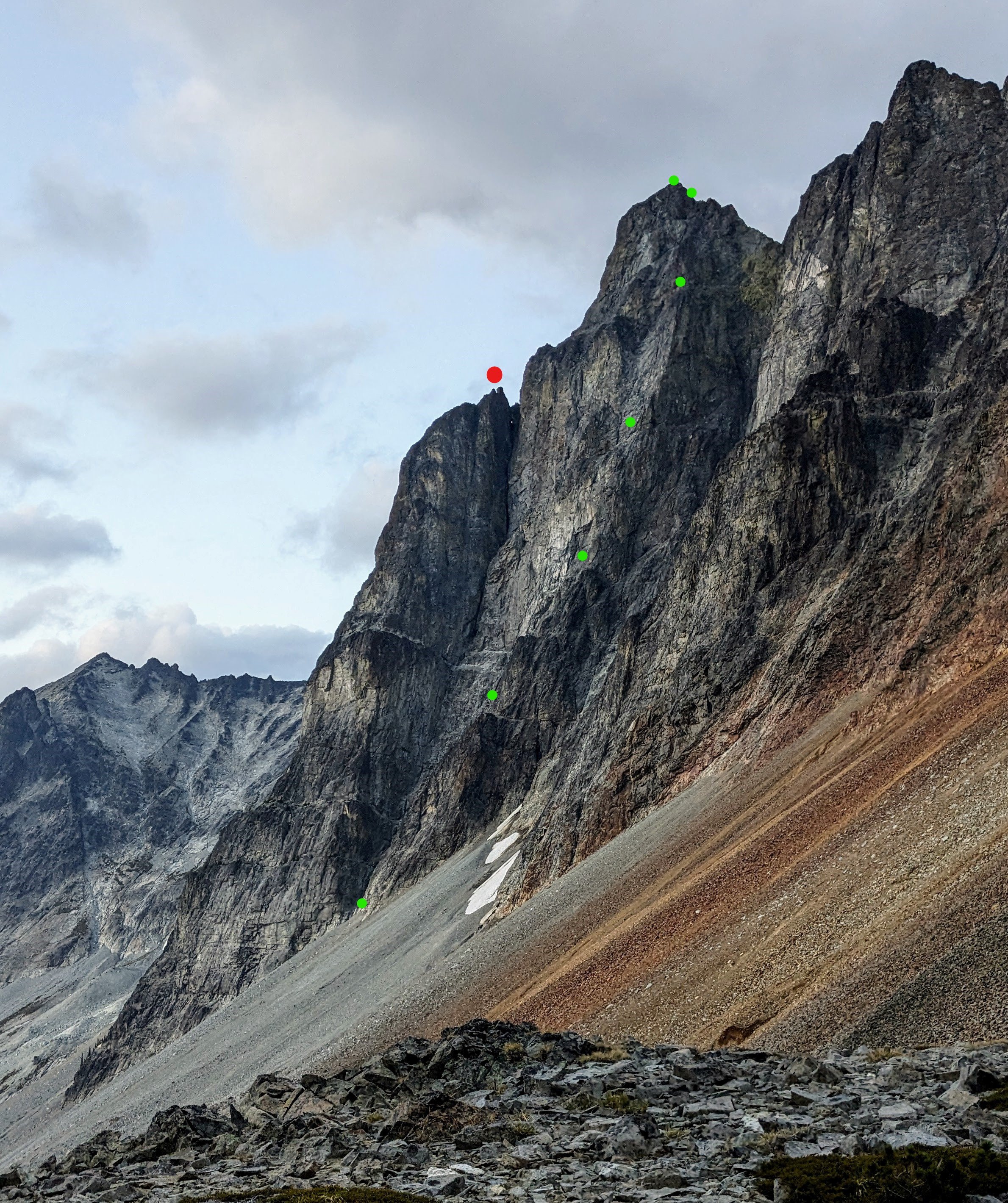
Trip: Bonanza Peak's Southwest Summit, West Face - Cascadian Route V 5.10+ Trip Date: 08/26/2023 Here's a couple obligatory John Scurlock photos of the western aspect of Bonanza's Southwest Summit: Trip Report: Summary: Sam Boyce and I took a 3-day weekend to climb a new route* on the West Face of Bonanza’s SW Summit. The Cascadian Route (V 5.10+) ascends Bonanza’s intimidating western wall. Our line gains >2,000 vertical feet over 16 pitches and 2,800’ of climbing. For context, our route is off to looker’s right of its neighbors to the north, the Soviet Route (1976) and the Oregonian Route (2013), both of which ascend the Northwest Buttress (previously also referred to as the "West Buttress", and in 1976 "the North Face") of the SW summit. In a marked up version of Sam's photo below: The approx. Cascadian route in green (each dot approx 3 pitches); the Soviet and Oregonian routes off to the left meet near the 8,700’ subsummit pinnacle on the skyline (red point), before ascending mellower terrain on the peak’s more-northern aspect (out of view; parties apparently traversed left under red roofs of the summit block): On the Scurlock photo, same color scheme (Soviet red, Cascadian green), but with the Oregonian start indicated by an orange dot: From the 9,320’ summit, we descended the Isella Glacier, which (as can be seen on satellite imagery) is split at approx. mid-height by a magically continuous undulating walkway. We were able to walk and downclimb (one low-fifth crux) to roughly 6,900’ without rappelling or touching snow, then used a notch/gully to drop through the peak’s south ridge before circling back up to our 7,000’ camp near the North Star – Bonanza col. Near the col above the bivy, there remains a small snow patch that provides water, even near the end of this hot dry 2023 summer. Report: Several years ago en route to climb Dark Peak with my friend Jon, we crossed (interminable and uniquely annoying scree) under Bonanza’s SW summit and gaped up at the expanse of rock on its western flank. I made a mental note to explore new routes if given the right conditions. Thanks to Sam’s can-do attitude and vision, and the forecasted wildfire smoke that ruled out other candidates, this was the moment. On Friday 25 Aug we made the time-consuming approach (car, Chelan-Lucerne ferry, Holden bus transport, many miles of walking); Saturday we finished the approach, climbed and descended to camp (15 hours, dawn to dusk); and early Sunday boogied out to catch the 10am Holden to Lucerne bus, then ferry, etc., etc. Would you believe the route looked this good all the way up? (Above: Sam follows the pleasurable 5.10a pitch 8, sends a sweet 5.10 corner on pitch 9, and earns his kale on the 5.10+ pitch 13 overhang) That would be a mistake: (Above: Eric confronts the heinous choss band of 5.8+ pitch 4, and the tricky steep delights of 5.10R pitch 12) While there were enjoyable stretches, there were also satiating portions of choss. Roof systems, particularly a large one that spans the west face feature near the top, provided few weaknesses and narrowed free-climbing line options to 1 or maybe 2 in places. We were both concerned about passage near the top, as bailing would be fraught and difficult. The technical highlights were five pitches of 5.10; three of these (pitches 8, 9 & 13) sported steep and fun climbing, but another two (pitches 11 & 12) were horsepuckey. For much of the climbing on these two steep 5.10R puckery pitches, literally not a single hold was loose; nah, haha, two or more were. While the featured rock inspired a kind of upward hope, protection was occasional, creative, and even whimsical—bring your bag of tricks. These pitches offered quality terror-tainment (@rat ©). This was a no meat-rain zone. The rest of the route predominantly ranged from mid-fifth to 5.8 on similarly varying rock quality—any given hold might be probably portable, or revealed as a solid protrusion of the mountain, eternally nonmoving and crank-able. Climbing of this sort can be extremely engaging and stimulating, and while Sam and I enjoyed moving up the route, it might not be to others’ tastes. For interested folks, he took concise notes on the pitches, and will hopefully chime in here with that info. * I encountered a 2.5” Trango Flex-Cam in a crack with a ‘biner attached on pitch 4, after the first heinous choss band but before the most technical climbing. This late-‘90s/early-aughts era cam was in a textbook placement and easily removed. The sling is weathered, perhaps had been sitting there for 10-20 years (hard tellin'). Anyway, given no evidence of passage in the pitches above, we surmise that perhaps this was used for bailing. A search for attempts or climbs of this feature has not borne fruit. However, if anyone knows better, please advise. Here are a few more photos. They don’t really do the route’s position and exposure justice, but they do serve to highlight the area’s rock/choss quality variability. (Above: choose your own adventure, then call your mom) (Above: In a move that typifies much of the climbing, Sam stems out in search of better rock) (Above: Eric following the overhanging section of 5.10+ on pitch 13) Here's an album with more pics, including descent: https://photos.app.goo.gl/8qAiXj6o4BfRSGJm9 Gear Notes: Lots of small gear was helpful, a bag of tricks (ball nuts, tricams) useful, and we also used some pins at belays. No need really for anything larger than a #3. 70m rope. Approach Notes: There are many ways to get there, but we took arguably the easiest starting via the ferry to Lucerne. Good bivy sites just south of the North Star – Bonanza col, around 7,000'
 1 point
 -
Trip: Uzbekistan - Alpomish - New Highpoint of Uzbekistan Trip Date: 08/23/2023 Trip Report: Alpomish (4668m, IV, 7 pitch 5.8), Highpoint of Uzbekistan, and Khazret Sultan (4643m, III, 2 pitch 5.7), Second Highest Peak in Uzbekistan Aug 21-26, 2023 Eric Gilbertson and Andreas Frydensberg First Ascent of Alpomish Andreas near the summit of Alpomish Aug 21 – Taxi to Sarytog village, hike in Aug 22 – Hike to base of Alpomish Aug 23 – Climb Alpomish (7 pitch 5.8) Aug 24 – Hike to base of Khazret Sultan Aug 25 – Climb Khazret Sultan (2 pitch 5.7) Aug 26 – Hike out, taxi to Dushanbe Until now it was widely accepted that Khazret Sultan Peak was the highest peak in Uzbekistan. I’m working on climbing country highpoints so it was on my list to climb. On this trip we discovered that Alpomish, a previously unclimbed peak, is in fact the true Uzbekistan highpoint. Khazret Sultan is located on the border with Tajikistan in the Gissar Range and is not a popular peak. It was most likely first climbed by Soviet mountaineers in the 1930s or in 1961, possibly a surveying team. It was first named Peak of the 22nd Party Congress, but this name was dropped after Uzbekistan gained independence. The peak was next climbed in August 2005 by Ginge Fullen and Tajik guide Tolic, climbing the northeast ridge from the Tajikistan side. This was Ginge’s third attempt to climb the highpoint and he discovered extremely valuable beta about the route and logistics. This would make it much easier for future climbers like me. The route On the summit they found the cairn left by the first ascent team. At that point the peak was officially unnamed and just referred to by its elevation, Peak 4643. This was the elevation measured on the most recent ground survey, the 1981 soviet topographic map. Based on the 1981 soviet topographic map, the most accurate map of the area, this was considered the highest peak in Uzbekistan. There were no higher peaks on the map and no subsequent ground surveys after 1981 of the area. In June 2010 a team of Uzbek climbers climbed the peak also from the Tajikistan side and later gave it the officially-recognized name of Khazret Sultan Peak. They officially recognized it as the highpoint of Uzbekistan. This unfortunately has led to a bit of confusion because there was already another peak named Mount Khazret Sultan in Uzbekistan at an elevation of 4083m. That is considered a holy mountain and is frequently climbed by pilgrims. It is not the country highpoint. Since 2010 there was one other known ascent, by Pat Bauman (solo) in August 2018 via the northeast ridge. Pat gave me excellent beta, saying the route was mostly 4th class with one or two pitches of 5.7 (which he soloed up and down). He also gave me a few GPS coordinates of key locations on the route. The 1981 Soviet topo map. Khazret Sultan is labeled 4643.3 but Alpomish is not surveyed I’ve been planning to climb Khazret Sultan every summer since 2019, but it never worked out. I always planned to tag it on at the end of another expedition but usually ran out of time. Finally in 2023 I again planned again to tag in on at the end of another expedition. I would climb my remaining snow leopard peaks Korzhenevskaya and Kommunizma in Tajikistan, then afterwards if I had time I’d go in with Andreas to climb Khazret Sultan. Since I’d already be in Tajikistan and the best route was from the Tajikistan side it should be straightforward. Before the trip, though, Andreas noticed open street map showed a peak called Alpomish with a higher elevation about 6km south of Khazret Sultan on the Tajikistan-Uzbekistan border. I found Gaia had similar results. I researched all topographic maps based on ground surveys of the area and purchased the relevant maps from mapstor.com. The 1981 soviet map was the only one with enough detail to show both peaks and appears to be the last ground survey conducted in the area. Interestingly, while the map had a spot elevation of 4643m on khazret sultan, there was no spot elevation for Alpomish. The topo lines for Alpomish showed it slightly shorter. But with no spot elevation for the summit that means the summit was not directly surveyed and the topo lines for the peak are just approximate. We then looked at satellite based measurements (SRTM) from google earth. The highest elevation points on each peak were exactly the same to the nearest meter. SRTM can have high errors up to 16m or more on sharp peaks, so this meant the two peaks were within error bounds of each other based on SRTM. Google maps terrain view had both within the 4600m contours but Alpomish was within a bigger contour. That usually, but not always, means the peak is taller. I believe the open street map, Gaia, and google terrain elevations are using digital elevation models (DEMs) to approximate elevations in between point measurements taken by satellites. They use different models so get slightly different elevations. The problem with the DEMs is that they are just approximations. Unless the satellite measurement sampled the exact summit of alpomish (very unlikely for a sharp peak), then there will always be unknown error in them DEM elevation. This seemed like a very interesting problem to solve. Which peak – Alpomish or Khazret Sultan – is the true country highpoint of Uzbekistan? Based on all existing information it was too close to know for sure. I could think of two ways to figure out the answer. The first was to fly a plane over Alpomish taking Lidar measurements which should be accurate to the nearest foot. That flight is unlikely to ever happen. The second is to go in and take ground measurements of alpomish. That I could do. Over the past year I’ve been acquiring survey equipment and skills that would be perfect for such an expedition. Just this july I finished an extensive survey project to find the true 100 highest peaks in Washington (results available at https://www.countryhighpoints.com/washington-top-100-peaks-updated-list/ ). I’ve conducted over a dozen ground surveys using sight levels, a theodolite, and a survey grade differential gps unit. I could apply those same skills and equipment to survey alpomish. My plan was to bring the differential GPS unit and sight levels to the summit of alpomish. The theodolite would be too heavy. The gps with a one hour measurement should give me an absolute elevation accurate to the within 3cm. As a backup I would use my 5x and 1x 10-arcminute sight levels to measure the angular inclination or declination looking from alpomish to khazret sultan. I could find the horizontal distance between them from Google earth and use trigonometry to find the relative height. I could then add the relative height to the known soviet-surveyed height of khazret sultan to find the absolute height of alpomish. To get more measurements to increase confidence I would then climb khazret sultan and repeat the whole process. I’d take an absolute height measurement with the differential GPS and also take angular measurements from khazret sultan looking back to alpomish. I could again calculate a relative height and use this to find the absolute height of alpomish. Also, if there were any intermediate locations of known elevation from the topo map I could use the sight levels to measure angular inclination up to alpomish and again find an absolute height. Finally, I would bring my handheld garmin 62s GPS for another independent source of height measurements. This has higher error than the differential GPS but could help increase confidence in whether alpomish is taller than khazret sultan or not. Ideally all measurements would agree. The more measurements I take that all agree the more confident I am in the final result. I usual am only comfortable if at least three independent measurements all agree before reporting a summit elevation. This was all a nice plan for surveying alpomish, but the more difficult part would likely be actually climbing it. I spent a lot of time trying to research if there had ever been previous ascents and I couldn’t find any information. We even had russian friends search in russian databases and they didn’t find any reports of ascents or attempts. This was intriguing. The peak had apparently never been surveyed accurately enough to know if it was the country highpoint and had never been climbed. This expedition sounded like true exploration. For better or worse with no beta or even pictures of the mountain I decided to come prepared for the worst. I would bring a full climbing rack with doubles of the intermediate pro, rock shoes, 60m rope, crampons, ice ax, and screws. I knew khazret sultan had a bit of rock climbing and was nearby so it was a good guess that alpomish might also involve rock climbing. We could make out glaciers at the base of alpomish from the satellite images so there was a good chance there might also be snow and ice climbing. Satellite images couldn’t really show if the peak was technical or not, though. With so much uncertainty in the route we decided to build in quite a few buffer days. We decided on one day to circumnavigate the peak to assess the best route and two days to climb the route. Then we gave ourselves two days to climb khazret sultan in case that had difficult route finding. We knew from Pat’s beta the best way in to khazret sultan was starting in sarytog village. However, it was unclear what the best way was to get from there to alpomish. I researched that there exists a trail over Mura pass nearby. That connects to an adjacent valley which would eventually lead up to alpomish. But it was very indirect – about 20 miles from khazret to alpomish. I played around a lot on Google earth and it looked like there was another option to climb up to a glacier up the valley from khazret sultan and cross a pass above that. Then we could try to stay high and cross one more glacier pass to get to the base of alpomish. That route was half the distance but there was more uncertainty in whether it would work. We decided to go for it, though, to save time. We probably had enough technical gear to make it work. So the full itinerary with all the buffer days added up to nine days. With all the climbing gear, survey equipment, and nine days of food that would make for very heavy packs. To help a bit we planned to climb alpomish first and cache extra food on the way in at the turnoff for the khazret sultan valley. I would bring an ursack so animals couldn’t get into our cached food. I liked going for alpomish first because it was the biggest prize, was the main objective for the trip, had the most uncertainty, and was the farthest away. Thus it made sense to prioritize. If we managed to climb alpomish, then khazret sultan would be easy to finish on in comparison. With the trip fully planned we started out on our primary expedition to finish the snow leopard peaks. We started by acclimating on Bazarduzu, the Azerbaijan highpoint, then flew to Tajikistan and moskvina glade basecamp in late July. Over the next few weeks we successfully climbed Pik Korzhenevskaya and Pik Kommunizma/Ismoil Somoni, finishing the snow leopards on Aug 16. Pik Kommunizma/Ismoil Somoni, Tajikistan highpoint and final snow leopard peak The next helicopter out of basecamp wasn’t scheduled until aug 26, but it turned out a group of climbers had arranged for a medical evacuation flight on aug 19. One of them had taken a fall and needed to go to the hospital. Helicoptering out of basecamp They were nice enough to let us squeeze on the flight, though we had to bribe the pilot to accept (even though the flight was completely paid for by the climbers’ insurance). We were lucky enough to fly all the way to dushanbe on aug 19, a full week ahead of schedule! This gave us plenty of time for our bonus objectives of alpomish and khazret sultan. The climber ended up being ok after visiting the hospital. Back in town with internet access we bought flights home for early september and took a full rest day to buy food for our next trip and repack. Then we were ready to go. Aug 21 After two nights at the Green House Hostel we left our extra gear stored and headed out in a taxi at 8am. Lucky for us our trailhead town Sarytog is located near Iskanderkul, a big lake in the mountains that is a popular tourist destination. So transportation would be easy. We paid $80 for the ride which went due north of dushanbe into the mountains. We stopped for an early lunch of sashleek along the way and made it to sarytog by noon. The road on our intended route appeared to continue past the village, but it was rough and our taxi driver was not interested in proceeding. So he dropped us off at the edge of town. We took down his WhatsApp number in case we wanted to call for a ride back, but didn’t want to arrange anything in advance. There was too much uncertainty in the trip timing. We could get lucky and finish early (unlikely) or need more time and stretch our food and get back late. We figured most likely we could just ask around in town whenever we got back and someone would be happy to make some extra money and drive us to dushanbe. Andreas stashed some flip flops in the bushes (a good idea I should have also done) then by 1230pm we started walking. For the first hour we walked along a gravel road out of town along the south side of the Capomok river. The road would be passable to a normal car most of the way. Halfway we passed a set of buildings and volleyball net that was labed Camp Archa the meadows on Gaia. I think this is a popular weekend destination for campers from Dushanbe. Hiking up the valley from Sarytog The road ended at the confluence with the Mura river and we stayed on the east side going up river on a decent trail. It got narrow in a few places on steep side slopes but was generally very good. We stopped for a brief break at the small village of Sarikhodan. This was at the turnoff for Mura pass. The village was only six small rock structures and I think the villagers are mostly shepherds in the area. From there we continued on good trails on the east side until we reached the dikondara confluence. On our map it looked like the west side was easier travelling, so we decided to cross. It wasn’t too bad – we just took of our shoes and waded through the shin deep cold water. Crossing the Dikondara river On the other side the river edge cliffed out but we hiked high on sheep trails and mostly had easy strolls through meadows. After the cliff section I noticed a wood bridge down at the river. We would keep that in mind for the return if needed. We continued through easy meadows on sheep trails until 6pm when we reached our planned cache location at the turnoff for the khazret sultan valley. There we waded across to the south side of the dikondara and found a good boulder to cache our food under. It would be easy to identify since there was a sheep carcass next to it. We continued a little farther to a nice flat meadow and pitched our tent there for the night. I boiled water in a tea kettle we’d bought in dushanbe since our reactor stove had gotten left at moskvina basecamp. The evening was surprisingly windy and we hoped it wouldn’t be like that for the summits. Camp at the turnoff for the khazret sultan valley Meteorologist Chris Tomer was continuing to send us daily forecasts to my inreach as he had done for korzhenevskaya and Kommunizma and it looked like the next few days would be good summit days. Aug 22 Our objective for the next day was to make it to the base of alpomish, about 10 miles away. It didn’t seem like a long day so I didn’t set an alarm. Around 7am we were woken up by a big dog poking his nose inside the tent! He soon left and I stuck my head out to see a shepherd on a donkey heading up the khazret sultan valley. He soon tied up the donkey and continued on foot. I suspect he was checking on some cows that we would later see grazing up there. Hiking up to the grassy cirque above camp He just happened to tie up the donkey next to our cached food and I was a bit nervous the dog might smell it and dig it out of the rocks I’d piled up. So I walked up there and moved the ursack to a different boulder closer to our tent. I figured the shepherd would assume it was related to the people in the tent and not mess with it. We soon packed up and continued up the valley. We followed sheep trails into a big basin with glaciers visible above then headed steeply up the right side. We found as long as there was grass there would be trails to follow, so we stuck to the grassy slopes as much as possible. We eventually ran out of grass and followed talus to the toe of the westernmost glacier in the basin, closest to the Uzbek border. The pass above the glacier is labelled pass 2 on gaia (but in russian/cyrillic). The glacier crossing to access the next valley The glacier was low angle enough and the ice/snow soft enough that we were able to continue all the way to the pass above around 4000m without putting on crampons. Interestingly I saw what looked like old sheep poop in some places and the pass had a small cairn. It appears shepherds must occasionally use that pass as a shortcut between valleys without needing to go all the way down to Mura pass. That’s pretty much exactly what we were doing too. It was very satisfying that all my research on Google earth had been accurate and the route had worked to the pass so far. The other side was low angle as I expected and we easily descended the scree and talus slopes to the next basin below. From there we traversed around the base of a ridge on 3rd class ledges to gain the next basin to the south. We crossed talus fields there to reach the toe of the largest glacier on the west end of the basin. The next glacier pass to cross This glacier was a bit steeper than the previous one and would likely require crampons to walk directly over. But there was a scree slope on the right side that looked doable. I was a little lazy about putting on crampons so opted for the scree slope. We made good progress and were soon at the pass. Surprisingly there was another cairn there. Perhaps shepherds use that pass too to get between valleys. We took a break at the pass and I noticed a formidable looking peak looming above to the southwest. It was composed of four steep spires like fingers sticking up from a hand. It was in the general direction of Alpomish. Andreas was skeptical that it was alpomish and I was hopeful it wasn’t since it looked really hard. We decided to get to our planned basecamp before worrying about it. From camp we could be certain which peak was alpomish. First view of alpomish From the pass we descended scree slopes then traversed around the ridge extending east from alpomish. We crossed some talus fields and eventually reached the small tarn at 3975m I had planned as our bacamp. The camp was perfect, and one of the most scenic I can remember camping at. The toe of a glacier ended in a tall ice cliff with waterfalls pouring into the tarn. The tarn had icebergs floating inside and was surrounded by boulders except for the southwest side which had a sandy beach next to the outflow. We pitched our tent on the beach by 6pm. Above us loomed Alpomish at the head of the unnamed glacier, as we verified on our map. For better or worse it was the same four-finger mountain we’d been intimidated by before. Now it looked even steeper. At basecamp for Alpomish It reminded me a lot of the east face of Mt Whitney in the Sierra nevada mountains of california. There was a huge granite face for each of the four spires. The left most (southern most) spire clearly looked the tallest, and I verified this with my sight levels. There was no obvious easiest way up and I was happy to have brought all the climbing gear. We would certainly need it. The next day was a planned scouting day and I hoped we could find some weakness in the peak once we walked closer for a better look. It was too late in the day to get any meaningful scouting in before dark though. But, I could get our first altitude measurement. I knew the altitude of the tarn from our topo map and could calculate the distance to the peak from gaia. Nice campsite by the tarn I measured angular inclinations using my 5x and 1x sight levels and got consistent results of 19 deg 50min. I calculated that alpomish was then between 4660m – 4670m tall. (There was a bit of uncertainty in the exact distance to the peak based on the topo lines on the map and this translated to uncertainty in altitude). That was significantly taller than khazret sultan! It was an intriguing result and already consistent with altitudes on gaia and open street map. I hoped I could get more measurements to increase confidence in the results. Sunset soon came and we went to bed. The forecast was for a sunny morning but slight chance of afternoon snow showers the next day, so we see our alarms to get up early. Approaching the east face of Alpomish Aug 23 We were up at sunrise and moving by 6am, ready for a potentially big day. The official plan was to do a scouting trip circumnavigating the mountain to look for a good route up. But we would bring all our climbing and surveying gear just in case we saw a good route to try that day. From camp we immediately got on the glacier and started walking towards the peak. As we got closer the features became easier to make out. The direct east face looked like good rock with cracks but would be very long. A gully went up to the left skyline which might work. There was a saddle to the right we could possibly use to get around to the back side of the peak. The rightmost spire looked like the easiest and maybe we could traverse from there to the summit. But that would require climbing the two intermediate spires which looked tough. Looking back towards camp There was a big gully leading up to the notch between the summit and the next spire to the right. From the notch to the summit looked short and doable. If that gully was scree or third class maybe the peak actually wouldn’t be too tough. We decided to go for the gully since it seemed like a reasonably high chance of success. Of course there could have been an even better way on the back side but we decided to gamble and try to go for the summit then instead of continuing scouting. This also had the advantage that we wouldn’t have to sneak over to the Uzbek side of the border, though I’m pretty sure that part of the border doesn’t get patrolled. Looking up at the east face We found an icy snow ramp at the base of the gully and cramponed up until the snow ran out at a slabby construction. We made a somewhat sketchy scramble up to scree slopes then traversed left onto third class blocks. The gully wrapped around to the left above us and we thought it looked all melted down to scree, so we ditched crampons and ice axes there. We continued up on third class blocks on the left side then met chossy scree up higher. We soon met a split with the left gully blocked by a huge chock stone. I guess that wasn’t too surprising in these kind of gullies. A right gully looked open and it was tempting to think it provided a way around the chockstone, but in my experience I judged that extremely unlikely. That gully most likely just led up to the notch between the next two spires. Climbing the east gully We climbed up to the chockstone and I saw light underneath, but it was too small of a hole to wriggle through. We would have to climb around. I changed into my climbing shoes and stashed my boots and poles and racked up. Luckily there was a crack on the face to the right that looked doable. Andreas belayed me up the face as I zippered it up with gear. At the top it turned into an overhang and I traversed left delicately on a steep slab to at last reach the top of the chockstone. I continued a little higher on scree to build a good anchor on the wall on the right. The pitch was about 5.7. Looking down from above the chockstone pitch Andreas didn’t bring rock shoes so climbed in hiking boots. I think the traverse was a bit trickier but he made it up fine. Above us we scrambled a little ways up chossy rock then encountered a constriction with a small waterfall in the middle. That was nice there was water to drink, but it meant there was probably ice and snow above us we hadn’t planned on. The constriction was steep and exposed so we decided to pitch it out. I led up again, managing to mantle up on the right side of the water to stay dry. Above it I climbed another small steep bit to an anchor on the left wall where the terrain turned back to scree. The pitch was 5.7. I belayed andreas up and then we noticed above us was a huge mass of ice filling the gully all the way up to the notch. If we could reach the notch the summit looked attainable. But we had ditched our crampons and ice axes. We would have needed technical tools and technical crampons and more ice screws anyway to make it up that. Ice leading up to the notch We optimistically scrambled up to the base to get a better look anyway just in case we could climb rock on the edge. But it was no use. We’d have to find a different way up. It looked like the only option was to move onto the face on our left and climb the remaining distance. Fortunately the rock looked protectable and climbable. Climbing the east face We descended back to my previous anchor on the left wall and I started up. I was able to follow ramps and ledges up to a nice ledge above for a 5.4 pitch. Andreas soon followed. Above that I tried to continue on ledges facing the gully but they got steeper and I needed to make a few stemming moves with an overhang to my left. I surmounted the overhang but then opted to traverse left to a ridge crest with a good belay ledge. That pitch was 5.7. Climbing the east face It looked like staying on the rock facing the gully was not going to work and we’d have to move farther left onto the main east face. The next pitch would be the crux of the route. I climbed a steeper 5.8 crack directly up the ridge crest. I poked my nose over to the right but it looked tough. So I instead made a delicate traverse left into a cleft. Shortly below me the cleft led to an overhang with extreme exposure but above looked doable. I made a few more moves to a ledge and belayed Andreas up. I think the delicate traverse was again tricky in hiking boots. Starting the final pitch From that belay I could see the summit, but the direct east face looked smooth and tough. I continued up the cleft and managed to cross back right to the rock facing the gully. There I found nice ledges and ran the rope out to its end for a 5.5 pitch. Finally the summit looked attainable! From that ledge I climbed directly up to the summit ridge behind a spire and crossed to the other side. I wove the rope around horns and followed the final knife edge ridge to at last reach the summit at 4pm. The final pitch was 5.5. Andreas on the final knife edge ridge to the summit I tagged the summit, which was a sharp bit on the knife edge. Then I downclimbed to a small boulder notch below. I slung the boulder and belayed Andreas up. Our route up alpomish Miraculously the predicted afternoon snow never materialized and we were treated to partly cloudy skies, warm temperatures, and no wind. It was a perfect summit day. We took a bunch of pictures and I looked over to the west side of the peak into Uzbekistan. Interestingly, it looked like glacier ice extended all the way up to the notch from that side. The rock between the summit and notch just looked like a few pitches and not too steep. So in theory if climbers came early season from the Uzbekistan side maybe they could just walk up snow to the notch and climb a few rock pitches to the summit. On the summit I soon brought out the survey gear and started setting up. I first made a quick verification with the sight level that all nearby spires of the peak were shorter, which was indeed true. We were definitely on the highest point. Then I got out the tripod, mounted the antenna and plugged in the differential GPS. I had a bit of trouble mounting the antenna somewhere so it could stand vertical and i eventually put it as high as I could between a boulder and the knife edge ridge. It needed to stand vertical for ideally one hour, so it didn't make sense for me to just hold it. I started logging data but it had trouble acquiring satellites for some unknown reason. I turned on my garmin 62s handheld unit and it was able to acquire satellites in the same location. Perhaps the boulder obstruction was an issue, but there weren't many options up there for mounting the device. Setting up the differential GPS unit near the summit I played around with settings a bit and finally decided to just let it take whatever measurements it could and I would try to process them later. I cursed myself for not taking test measurements on the way in, but it had worked fine on my last trip in Washington. It's possible the issue was related to me being outside the US. I was happy I had backup measurement equipment though, which would still suffice for measuring the altitude of alpomish in case the differential GPS didn’t work. I then took out my 5x and 1x sight levels and pointed them towards khazret sultan as verified by gaia. With each sight level I measured 10-20min angular declination looking down at khazret sultan. Clearly khazret sultan was shorter. Andreas on the summit I also noted altitude measurements from the garmin 62s and from my garmin fenix 6 watch after gps calibration. We hung out on top until 5pm taking measurements but then had to get down. I hadn’t found any evidence of anchors or cairns or any human presence so it seemed very likely we had made the first ascent of alpomish. Anyone else climbing such a technical peak would likely have rappelled off, but we saw no rap anchor evidence. I had come prepared with a lot of rap gear, though, and was experienced making rap anchors from my big wall climbing expeditions in the northwest territories, canada. View from the summit I slung a rock horn near the summit, backed it up with a cam, and started down. We only had a 60m rope so would need to make a lot of rappells (I wished then that we’d brought twin ropes, but that would have been heavier to hike in with). I planned to rap directly back into the gully since that would be shorter than our ascent route and hopefully require leaving less gear on the mountain. We couldn’t rap directly to the notch, though, since it looked too sketchy to then get down the steep ice without crampons. So I planned to do diagonal rappels until we were clear of the ice, then rap straight down. It’s a little bold to rap down a face we hadn’t climbed up, but it looked featured enough that I could probably make enough anchors. Looking at khazret sultan I rapped down diagonally and found another good horn at a good ledge to sling. I built the next anchor, then Andreas followed. I again made another diagonal rappell on ledges and again found another good horn to sling. Horns are great because I just have to leave some cord as an anchor. I’d brought 30m of 5mm cord for this purpose and it was relatively cheap. Unfortunately one problem with diagonal rappells on loose non vertical terrain is the rope pulls aren’t always smooth. On that pull the rope got caught on a rock and when I yanked it the fist sized rock dislodged from about 20ft above us. It grazed Andreas on the rear end but he said he was ok. Rapping down I next rapped into an icy gully and over to a ledge on the side. Unfortunately there were no horns. My second choice rap anchor is a two-nut anchor. Nuts are cheap – about $10 a piece – so it’s not too bad to leave a few. And they can be very solid. We were still over the ice so did another diagonal rappell on ledges. Again there were no horns so I had to leave another two-nut anchor. Finally we appeared to be nearly clear of the ice. I next rapped straight down to a ledge just above the ice and found a good horn to sling. Andreas joined and by then it was finally dark enough for headlamps. I think we were pretty efficient at 30min per rap. At the last rope throw the ends reached the bottom of the ice and we were soon safely back on scree in the gully. But we werent quite off the technical section yet. We walked down to the top of the waterfall pitch and I slung another horn. That pitch had seemed long, but by rapping directly down and relying on some rope stretch we just barely reached the scree below the waterfall. Rapping down the final chockstone pitch We then walked to the chockstone and slung a boulder above. That had been a long and indirect pitch too. But, by rapping directly over the chockstone we again barely reached the scree below. Finally by 9pm we were off the last technical section. I switched back to boots and we carefully hiked and scrambled down the chossy gully. After retrieving our stashed crampons we decided to try to avoid down climbing the sketchy slabs to the snow ramp. We instead continued scrambling down the blocky 3rd class stretch. It eventually cliffed out, but we were able to traverse onto the snow ramp at a safe spot. From there we cramponed down in the dark following our ascent route. We finally staggered back to camp at 11pm for a long 17 hour day. Last view before leaving basecamp Aug 24 We were several days ahead of schedule, but Chris forecast bad weather coming in Aug 27 that might leave a foot of snow on the summits for a long time. So we didn’t want to take any rest days to delay things. We allowed ourselves to sleep in, though, and were up and moving by 10am. The goal for the day was to move camp to the base of khazret sultan. All measurements had so far indicated alpomish was significantly taller, but we still wanted to be thorough and get final measurements from the summit of khazret sultan to be absolutely certain with our conclusion. View of alpomish from the hike out. Summit is the left spire We followed the exact same high route crossing the two glaciated passes. At the last pass we started getting snow flurries and by the time we reached our food cache at 430pm there was intermittent drizzle. We were very fortunate that hadn’t happened the previous day on alpomish. Crossing the first glacier pass We took a short break, got a little but of food out of the cache, then started up the khazret sultan valley at 5pm. We had earlier seen the shepherd go up the left side of the river so we stayed on that side too. The trail started good but soon deteriorated. We made slow progress along the steep sidehill full of talus. The light rain made the boulders slippery and we had to be extra careful. Finally we were able to cross to the right side and travel eased. We hiked a chossy slope up to an upper basin then hugged the right side on cow trails in the grass. Ascending the valley towards khazret sultan We reached the end of the grass by sunset and pushed on to a small tarn at 3970m a little farther up where we leveled out a campsite. I had hoped to reach the basin at the base of the khazret sultan route that day so we could scout the route, but it didn’t make sense proceeding in the dark with unknown water source locations. So we slept there for the night. Aug 25 The next day was forecast to be sunny until 11am then increasing chances of snow up to 1 inch on the afternoon. We expected khazret sultan to be mostly 4th class so would hopefully go much faster than alpomish. Starting up the valley at sunrise We were up and moving by 6am, and unfortunately the rocks were all icy. The evening rain had frozen on the rocks overnight. We hoped the sun could de-ice the route by the time we got on it. At the base of khazret sultan We hiked up talus to eventually reach the basin at the base of the southeast face of khazret sultan. From there Pat’s route was to hike up a gully to gain the east ridge, the follow that to the northeast ridge, then follow that to the summit. Hiking up to the northeast ridge This looked pretty circuitous and the ridges looked tough from below. But we optimistically trusted Pat that it was mostly 4th class and went for it. (For reference, Pat has free-soloed big wall routes on half dome in yosemite, so I suspected his 4th class was a bit stiffer than mine). I racked up at the bottom of the gully and we hiked up easy scree and talus to a big notch on the top. From there we turned left and continued up another wide choss gully all the way to a col at the intersection with the northeast ridge. I was amazed how much progress we could make on easy terrain and still not need to do any scrambling. That was not at all obvious from below. Good ledges on the north side. Summit in background We peered over the col at the northeast ridge and were met with a big cliff dropping of to the north basin. The route definitely didn’t go there. Staying on the ridge crest looked technical so we dropped back 10m and traversed across a good ledge below the ridge. We could soon scramble back up to the ridge crest. The crest looked 4th class from there so we scrambled a bit along it. We then moved to the left side and had to wriggle down a chimney to some dirty ledges that dead ended. Looking back along the ridge The terrain looked steep above but that was the only way forward. I switched to climbing shoes but this time kept the boots, crampons, and whippet. I didn’t want to get turned around by snow and ice. I ended up placing just one cam, then crossed the ridge and found a huge ledge system. I belayed andreas up and we packed up the rope. The crux technical section up from the notch From there we scrambled either on ledges to the right of the crest or exactly on the ridge crest. Any rock in the shadows was a bit sketchy since the ice hadn’t yet melted off. So we had to be very careful. We eventually reached a deep notch in the ridge and the terrain above looked technical. The right side of the ridge looked loose, chossy, and icy. I chose to climb directly up the crest from the notch. It was technical but at least not icy. Looking across the north basin I climbed some loose rock below then made a few low 5th class moves to a nice ledge. I noticed a slung boulder there so it appeared we were on the same route others had taken. I don't think this peak sees many ascents, though. I only know for sure of four ascents. I belayed andreas up then started up the next pitch. There was a piton down low, then I climbed a fun 5.7 corner. I eventually pulled myself up onto a pedestal and clipped an existing rap anchor that was a big black 11mm static line. This may have been left by Ginge. Climbing along the northeast ridge at the top of the 5.7 pitch That was the last technical section out of the notch. Andreas belayed me farther on 4th class terrain until I reached a chossy ridge. There we put the rope away and descended slightly to another notch with some snow in it. On the broad foresummit I switched to boots and we continued up choss, then talus, then 3rd class blocks on the other side. We eventually walked up loose slopes to a broad summit. A horn was slung and a sign saying Ucell and a bunch of Russian text hung from it. Slightly farther along the ridge we saw a huge cairn with a bamboo pole sticking out. That looked like the summit. Unfortunately it was along a technical ridge. So I put my rock shoes back on and Andreas belayed me one more pitch to the summit, which I reached by noon. Our route up Khazret Sultan I built an anchor, belayed him over, then we stopped to take in the view. Glaciated rocky technical looking peaks surrounded us. Far below were grassy valleys where sheep likely grazed. It was very scenic. The final pitch to the summit of khazret sultan I looked over towards alpomish and the four spires were meshed into one ridge because of the angle, but the peak location was obvious. I took out my sight levels and measured 10-20 minute angular inclination up to alpomish. This was exactly consistent with my previous measurements and confirmed alpomish is indeed taller than khazret sultan and is the true country highpoint of Uzbekistan. Taking sight level measurements from the summit I also took measurements with my Garmin 62s handheld GPS and my gps calibrated garmin fenix 6. Both measurements had khazret sultan lower so all measurements (ten in all) were consistent that alpomish was the true highpoint. Both on the summit I hadn’t bothered to take up the differential GPS since i hadnt been able to figure out which settings to change to allow it to start acquiring satellites. And khazret sultan already had a very accurate ground survey elevation from the 1981 soviet map. The next spire along the ridge that is the true summit I next took sight level readings of the different spires in the summit area and noticed the sharp spire with bird poop on top farther along the ridge was perhaps a few inches taller than the cairn summit. We each went over to tag it just to be sure. Hiking back from the summit After taking all the measurements and writing them down in my field notebook I belayed andreas back across the ridge. I had instructed him to leave all the pro in on the way over so he could easily reclip on the way back. I changed back into boots and quickly started back down the route. We could see rain in the distance towards Sarytog and a few snow flurries were starting to hit. This was just as Chris had predicted. I knew if the 4th class rock got wet it could get sketchy so we needed to get down asap. Rapping down the notch We scrambled down to the snowy notch then up the choss on the other side. This time we continued scrambling the fourth class ridge along to the top rap anchor. I backed it up then rapped down to the intermediate ledge. We then used the existing anchor there, backed up, and rapped to the notch. It was so much faster with these existing anchors than it had been descending alpomish! Scrambling back along the northeast ridge in deteriorating weather At the notch we packed up the rope and started scrambling. Luckily by then the ice had melted off the rocks on the north side so it felt a bit more secure. But the snow and wind started picking up and the rocks started to get wet. We got to the end of the fourth class section and I built an anchor to rap off the first bit we had pitched out. With the wet rock I decided to pitch out the final fourth class section also. I climbed up the chimney, across the steep ridge, and was finally back to a third class ledge. Final scramble section I belayed Andreas up and we finally packed up the rope for good. It seemed like we’d gotten off the steep part of the route just in time before it got wet. From there we descended easy 3rd class ledges to our stashed hiking poles then scree surfed back to the basin below. We hiked back on talus, reaching our camp by 430pm. The clouds looked very dark down towards Sarytog and it looked like we’d missed the brunt of the precipitation, but the summit still looked windy and snowy. Good views of the dikon glacier below We quickly packed up and headed down. This time we stayed on the left (north) side of the river and were able to follow nice animal trails down. We actually saw a few cows grazing up there. By 7pm we waded back across the river to our previous campsite. We picked up our cached food, set up the tent, and were asleep by sunset. Hiking back to camp Aug 26 The next morning by 630am we waded back across to the west side of the river and followed our ascent route down. Progress was fast and this time we used the bridge to cross back to the east side among a herd of cattle. We had to wade across a few tributaries but mostly followed good trails. At one point a shepherd caught up to us and he seemed amused we were walking instead of riding horses. Camp down in the lower valley He turned off at Sarikonda village while we continued back to Sarytog by 11am. We found the Dornish Guest House there that fed us lunch and one of the owners was able to provide a taxi ride back to Dushanbe. We made it to Dushanbe that afternoon and returned to the Green House Hostel. I was glad we had made it out ahead of schedule since all the next day it rained and thunderstormed in town with widespread flooding nearby. The power was out and running water cut off to the entire city! I heard in the mountains they were getting a foot of snow! The routes up alpomish and khazret sultan probably would be out for a while. Hiking out I later processed my measurements and, based on the angular measurements I took and the known distance between alpomish and khazret sultan, I calculated alpomish is 25m +/-8m taller than khazret sultan. So given khazret sultan has a surveyed elevation of 4643m from the soviet map this means I measured alpomish has an elevation of 4668m +/-8m. This is consistent with the measurements taken from the tarn. This means Alpomish is the true country highpoint of Uzbekistan. After we got back to Dushanbe we had just barely enough time to climb Ayrybaba, the Turkmenistan highpoint. This completed our five-year project to climb the Highpoints of the Stans – the country highpoints of Afghanistan (Noshaq 7493m), Pakistan (K2 8611m), Kygyzstan (Pobeda 7439m), Kazakhstan (Khan Tengri 7000m), Tajikistan (Ismoil Somoni 7495m), Uzbekistan (Alpomish 4668m) and Turkmenistan (Ayrybaba 3139m). Link to more pictures: https://www.countryhighpoints.com/alpomish-uzbekistan-highpoint/ Gear Notes: Standard rack to 3", doubles of intermediate sizes, 60m rope, lots of tat and nuts for rap anchors, glacier gear, survey equipment Approach Notes: From Sarytog village hike up Dikondara river, cross two 4000m glaciated passes near Uzbekistan border, access valley east of Alpomish.1 point