
Leaderboard


Popular Content
Showing content with the highest reputation on 10/07/25 in Posts
-
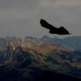
Trip: Strathcona Provincial Park Ramblings - Big Interior, Septimus, and Kings Peaks Trip Date: 07/21/2025 Trip Report: This past July @Trent and I went on a ramble to Strathcona Provincial Park up on Vancouver Island. We were supposed to meet up with @wbk at the end of the week to give the Colonel Foster Traverse a go, but we wanted to ease into it. And so we did, sort of. Or maybe we just got schooled by the "Island Alpine" we had heard so much about from @wbk. First off we had to navigate the BC ferry options to the island, which tend to book up early. Nevertheless their ferry system makes ours look decidedly second class, and it all worked our pretty smoothly once we were booked and in line. First stop was the trail to Bedwell Lake which I suppose is a good trail by Island standards, but a grunt nontheless. The bugs weren't bad at the lake but increasingly became annoying as we climbed to our camp just below Jim Lake. We were up early the next morning, rambling up and across on the climber's path to Big Interior. It turns out most use this as an approach to Nine Peaks, but we didn't fancy carrying all of our overnight and climbing gear over the summit and so we settled for the "approach" summit of Big Interior. The bugs, heat, and humidity followed us every step of the way. Nine Peaks from Big Interior: @Trent pulling up on to the summit of Big Interior: The views, of course, were grand, and we barely knew any of the peaks in any direction. So much to do in every range it seems like, there is never enough time to climb them all! But we at least had to climb another on this trip, so we reluctantly retraced our steps to camp. And then promptly moved it to Cream lake, to prepare for the aptly named Green Ridge on Septimus. Camp at Cream lake with Septimus looming above: Septimus: Cream lake: We were up early the next morning, crashing around the lake and down, down, down to meet the start of the Green ridge. Do not underestimate this approach! It is every bit a thrash as anything in the Pickets or North Cascades and was especially character building in the heat, bugs, and humidity. Thankfully we were through most of it in a few hours and soon battling the steep rock and veg into the alpine. @Trent out of the brush and about to do battle with steep veg on the Green Ridge: But soon enough we emerged into the full blown Island Alpine and the grand north wall of Septimus and Rosseau was revealed: Looking down at Green lake from Green Ridge: As we scrambled higher, we came across one of the more vivid bits of rock I have encountered in the mountains. Maybe some pillow basalts that have been smoothed by ice? And then a short rap, some steep snow and steeper rock (but still 4th class) as we wheezed our way above the bugs and on to the summit of Septimus: @Trent on the summit of Septimus: There was quite a flower garden directly on the summit of Septimus: And then the 5-6 raps down the South (regular) route on Septimus. We had heard that you may need two ropes to make this work, but it went fine with a single 60m. Take care if anyone is below you though, much loose rock! By the time we got back to camp it was late afternoon, the bugs were fierce, and a swim was called for to think about our options. It was decided that we would spend another night at Cream Lake, hike out for a "rest" day and then try for a single day trip before meeting up with @wbk later in the week for Colonel Foster. I mean, we're going to do all that, right? But first, there was a sunset to enjoy: In the morning the bugs were still fierce, the heat and humidity back in full force as we packed up to hike the Bedwell trail back to the car. Parting view of Septimus: Big Interior and Bedwell Lake: Thanks to a friendly campground host in the park, we found an excellent free place to camp just outside the park and on the way to Gold River. It was about this point that our appetite for Colonel Foster was waning as the pull of home and no bugs was growing stronger: But first, another peak! We had chosen the "hiker's" route up Kings Peak as the day trip the following, knowing that it was a big grunt and was likely to be hot and buggy as well. Still, it was enough of a challenge as to feel like easy mountaineering, and it was hard to beat the views. There are loads of very steep climbs on Kings, maybe the highest concentration of hard routes on any peak in Strathcona Provincial Park. But we didn't climb any of them! We did oogle other nearby mountains like Elkhorn, for a future trip to the Island: And of course, the Colonel: Soon we were on the summit with the ravens on a perfect day, finally above the bugs and the heat, feeling the bliss of "Island Alpine": But it wouldn't last. We were tired from 5 days of rugged Island peak bagging, and a bit mad from the bugs as we descended. We got in the car, changed our ferry reservation and headed home. Sorry @wbk, we'll have to come back for the Colonel! Gear Notes: 60m half rope (Septimus Green Arete), ice axe, helmet, crampons Approach Notes: BC Ferries1 point
-
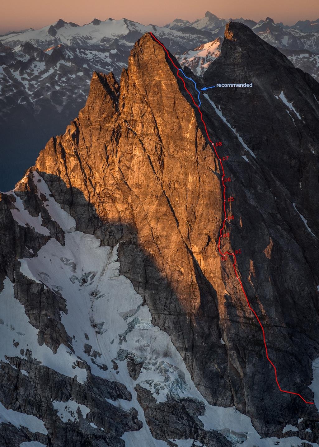
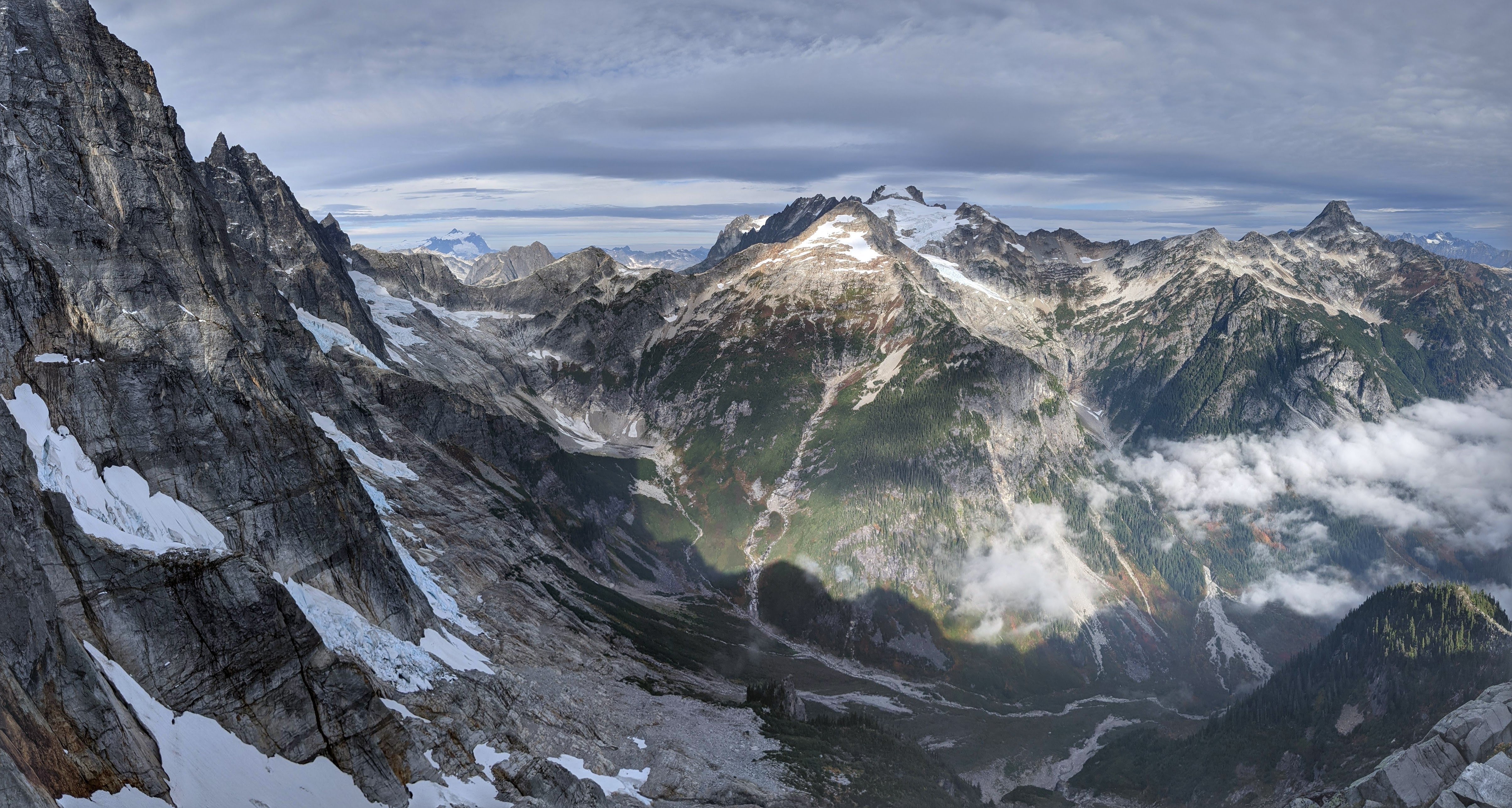
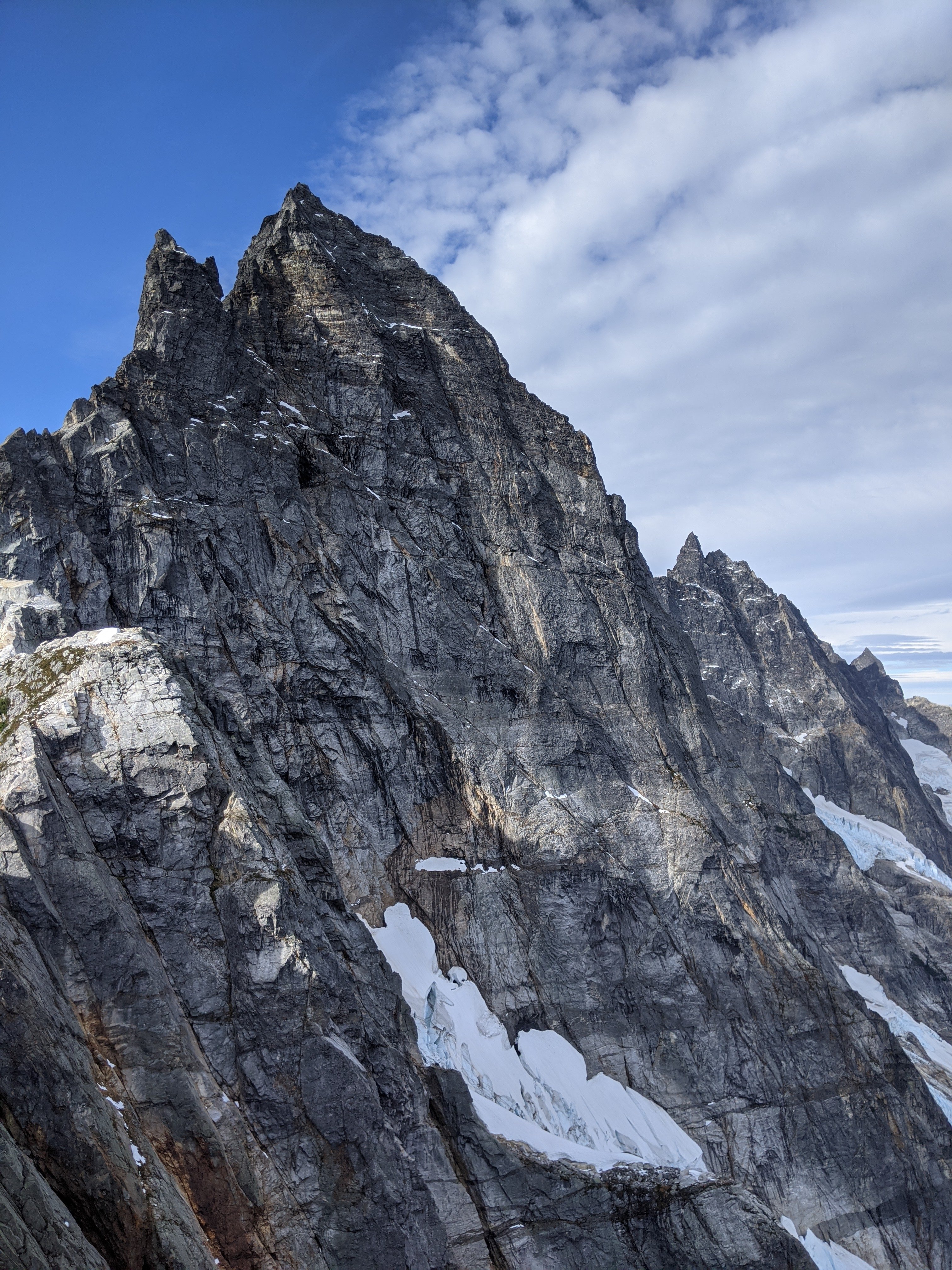
Thanks for the kind words. And yeah, it was way more casual than I expected. I figured there was a decent chance we'd climb through the night. But, nothing went wrong (mostly, we didn't blank out and have to pendulum). Also, while I expected decent rock compared to the Pickets reputation, the rock was vastly better than I'd dared hope. Like, legitimately good. I could list a lot of local granite routes with similar or worse rock. I mean, this is obviously an extremely serious route and environment with some loose, wet, and vegetated rock, and a slight deviation from our path could yield a very different experience. Bailing would be spectacularly unpleasant and expensive. But it's also a much more pleasant and, yeah, casual route than I would have ever expected. And right, re: snow on the approach: the 76/86/08 parties encountered substantial difficulties with glaciers/ice blocks. I also know someone that recently tried to traverse under the McMillan cirque North faces from Stettatle Ridge in late spring, and was turned around by some weird messed up crevasse situation with what seems to be a seasonal glacier (following roughly the Volken ski approach). But, I think they were lower than you'd be to approach the buttress, so maybe it's not a big problem these days. These glacial remnants seem to always be gone by Sept, and we just had one short section under some mildly threatening blocks where we felt the need to scoot (similar to approaching Triumph NE ridge). Here's some more detail: Approach: from the Terror basin bivy, walk/scramble up slabs diagonally toward base of Little Mac. There are bivy sites with year-round water around 6400-6700ft below/S of Little Mac. Find a narrow ledge below Little Mac to access the NE trending ridge toward Elephant Butte. Scramble NE along this ridge for 10-20 minutes, finding a slung boulder about 50m before the first low point/col. Make four 45-55m rappels starting from the boulder, at first in the corner. After the second rappel, walk 20m skiers right on a ledge to find another slung boulder. The fourth rappel finishes over a rotten, red overhang. From the base of the rappels, walk/scramble to the base of the buttress, continuing around to the right/W side, and scramble up and back left toward the crest. In late season (Sept) there will likely be no need to cross snow (although plentiful flowing water), with one area below broken up ice blocks where you’ll want to scoot with some urgency. Early season, though, there may be a seasonal glacier with substantial crevassing that could hinder access (a la Slesse). Route: When the buttress steepens to fifth class, simul climb for 200-300m until a ledge where it steepens further and the pitched climbing begins. Looking up, you will see the buttress crest on your left, then to its right a right-facing corner (2008 route, we think, we climbed this), a rotten looking roof, and further right another weakness/corner (1986 route, I think). Belayed pitches range from perhaps 5.8 to 5.10-, and it’s hard to give per-pitch grades, but p3 is the mental and physical crux. p1 (50m): Begin in the corner directly below the rotten roof (to the right of the upper, left-hand R-facing corner that you're aiming for). When the cracks become wet and filled with moss, traverse a couple of meters right to a cleaner corner, and belay just below the rotten roof. Note: this is what we did, but it may be better to take the next corner left, which aims you straight toward the left end of the chossy looking roof, and thus avoid the traversing pitching. p2 (20-30m): Traverse horizontally left, out from under the chossy roof, passing below another crackless roof/overlap, aiming for the solid/clean rock near the crest. Belay near two rusty pins. p3 (45m): From the old pin anchor, go up and left into the solid corner with clean cracks, passing an ominous looking fridge-sized block that, once you reach it, sounds solid enough to (gingerly) climb on. Continue up placing gear behind surprisingly solid flakes to pass a small roof, emerging on a slab that provides entry to the large R-facing corner at which you've been aiming. Climb the slab up and into the corner on solid rock, but at times little gear, until you can step right onto a pedestal belay. p4 (50m): Climb up from the pedestal toward the left side of the mossy, chossy-looking roof; but traverse right just under the roof on solid, clean face holds, using the roof only at its solid right edge. Emerge onto a large grassy ledge, climb up solid blocks/boulders into a steep, splitter thin hand/finger crack leading to another, larger but sloping grassy ledge. Continue up the grass/heather slightly rightwards to belay at the base of a corner. p5 (45m): Go up and right on the face R of the corner. There are numerous options but they all deposit you on a small sloping ledge where the face converges below the main corner. p6 (50m): Climb up cracks and grooves on the right wall of the corner, aiming for the right side of an overlap below a larger roof. After placing gear in the roof, step left above the overlap and continue up to belay in a small sloping alcove. p7 (50m): Climb rightwards out of the alcove, passing a small roof on its right to emerge onto a rightward-sloping ledge. Walking right will lead to bivy sites; but if not bivying, continue straight up into a steeper, shallow corner with several cruxes (one just off the ledge), belay when you find a good stance. p8 (50m): Climb straight up in a slightly easier corner/groove, stopping to belay when the angle eases. You are now in the schist band: rock quality deteriorates. Simul climb for 50-60m, straight up a broad depression, exiting on steeper, splitter cracks slightly rightwards leading to lower angle slopes facing more westward. We continued simuling, aiming for a steeper ramp 30-50m right of the crest, which had a fixed pin, but was the only bad/scary/chossy pitch of the route. Not recommended. Instead, after exiting the steep cracks, stay low and traverse harder right toward the E Mac-W Mac col, until you reach a broad depression leading straight up (3rd class) to the summit. Descent: Downclimb SW toward the E Mac-W Mac col (2nd-3rd, one 4th move at bottom). Continue downclimbing the dirty gully S for 50-100m, looking for where the left wall of the gully becomes less steep/flat (i.e. creates a small shoulder), where you will find a slung boulder. Make four 45-55m rappels roughly straight down off slung horns/boulders to reach lower-angle slopes. And a route line on a gorgeous picture by @JasonG (happy to pass along higher resolution, just ask): And finally views of the upper and lower buttress, and the rappel corner, from a little past the rappel point:
 1 point
 -
Wow! Such a great story and achievement, but most of all it seems that this experience was very powerful for you. The best adventures are those ones that give you appreciation for the richness of life. I'm happy you got to experience this. Thanks for sharing here.1 point