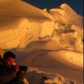
Josh Lewis Posted May 25, 2010 Share Posted May 25, 2010 Trip: Two Tales on Navaho - Date: 5/23/2010 Trip Report: Trip Stats: Time: 9 Hours Date: May 23, 2010 Distance: 13.2 Miles Who Came: Eastking, Curtissimo, Mtn. Climber, ONELUV1, Jimbopo, and I Destinations: Navaho Peak and Little Navaho Elevation gain: 4,100 Feet Max Hieght: 7,200 Feet on Navaho The trip started out us all meeting together at the Issaquah Parking Ride, although we met Mtn. Climber at the trailhead. When we got to the East side the weather was much better than the west. Unfortunately we all knew that this clear weather would not last long, so we hit the trail around 9 a.m. Curtissimo was working up quiet a pace, I had to jog to keep up with him which was hard on my shins, and some how the start for me was the hardest part of the trip. Curtissimo soon slowed down, and the pace was decent by this point. As we went further and further through the valley the weather took a turn, it started to snow, which was no suprise to me, infact the conditions were much better than I had anticipated. The trail by this point was nowhere to be found, so we had to navigate a little to get up to the ridge, and figure out which peak was Navaho. I'll admit most of us did not believe Eastking when he said it was the tree covered one, but eventually we all realized he was right that it was. http://hikrs.com/host/Panoramas/navaho/View%20below%20the%20Pass.jpg Then we traversed east to get onto the ridge of Navaho. Views of the Enchanments opened up, but soon got foggy. After a few moments things cleared up, which I was amazed at how long views cleared up for. http://hikrs.com/host/Panoramas/navaho/B&W%20Enchanments.jpg http://hikrs.com/host/Panoramas/navaho/Foggy%20Enchanments.jpg http://hikrs.com/host/Panoramas/navaho/Creek.jpg The Summit Ridge was nice, when Mount Stuart came out of the clouds it kept stealing my attention. As I near The group, I ask "Is this the summit?" Eastking replied "no its four more miles". I thought "oh man!", but fortunately he was kidding. Soon I too was on the summit. http://hikrs.com/host/Panoramas/navaho/Summit%20Panorama.jpg We took some quick photos, had some food, and of course put on more clothes because it was freezing up there. It was now time for part two of the trip, Little Navaho. We decended the ridge in very good time, avoiding the cornice to our left. Towards the bottom there was a bit of class 2 loose rock we had to be careful of. As we went down we got caught in a storm I knew was unavoidable, it was now snowing with some winds. When we got to the bottom I must of had 100 pebbles in my boots so I had to get them out. :lol: By this point I became quite cold, but felt better once I had my jacket on (my armor). The place became enchanting quite fast, you really felt like you were mountaineering by this point. The snow got inside my pack fast too when grabbing my jacket. Heading up to Little Navaho for most of us was the funnest part of the trip. :up: :up: After heading up a ways through the storm things calmed down, and soon we got to our next summit. Although we got a sunclearing, there was no view from the top, atleast earlier's views were enough to satisfy us. On the way down there were some nice glassades. We went down a snowed over creek to get towards the bottom, followed a rocky ridge, and to my amazement found the trail! From here on out we got to do some trail jogging to get down, although after a while it began to feel longer than what I had remembered, but don't most peaks do that? We arrived around the trailhead at 6 p.m. This proved to be an awesome choice for a hike, hope next weekends will be atleast as good if not better! Quote Link to comment Share on other sites More sharing options...
cascadesdj Posted May 25, 2010 Share Posted May 25, 2010 Nice pix with some great lighting. Quote Link to comment Share on other sites More sharing options...
mountainsloth Posted May 25, 2010 Share Posted May 25, 2010 cool! looks like a fun trip! Quote Link to comment Share on other sites More sharing options...
OlympicMtnBoy Posted May 25, 2010 Share Posted May 25, 2010 Nice trip Josh, I like all the pics interspersed with your report. Quote Link to comment Share on other sites More sharing options...
pms Posted May 26, 2010 Share Posted May 26, 2010 nice, I love that peak. Miller to Navaho traverse is a favorite. Quote Link to comment Share on other sites More sharing options...
SemoreJugs Posted May 31, 2010 Share Posted May 31, 2010 I enjoyed the black and white atmosphere / light interplays on the mountain shots... What also stands out on this TR is that there are no "Oh Shit!" moments on the entire trip. Excellent! Quote Link to comment Share on other sites More sharing options...
Josh Lewis Posted May 31, 2010 Author Share Posted May 31, 2010 I enjoyed the black and white atmosphere / light interplays on the mountain shots... What also stands out on this TR is that there are no "Oh Shit!" moments on the entire trip. Excellent! Most of the time I mention everything that goes down in the report, this time I left out the details where my feet went numb from lack of gaitors, but that was about it. Glad you liked it, also thanks everyone else. Quote Link to comment Share on other sites More sharing options...
summitchaserCJB Posted May 31, 2010 Share Posted May 31, 2010 Nice pictures. What setup do you have? Quote Link to comment Share on other sites More sharing options...
Josh Lewis Posted May 31, 2010 Author Share Posted May 31, 2010 Nice pictures. What setup do you have? I use a Power shot SD 1200 IS Digital Elph Canon As for the settings I swapped a lot on the manual mode using B&W, and sometimes diffrent light settings and such. Quote Link to comment Share on other sites More sharing options...


Recommended Posts
Join the conversation
You can post now and register later. If you have an account, sign in now to post with your account.