Search the Community
Showing results for tags 'alaska'.
-
Trip: Denali - Denali Diamond Date: 6/19/2007 Trip Report: At Colin's and others' request, I'm posting as a trip report an email I already sent out to friends, with a few additional photos added. Enjoy. -MW We flew to Kahiltna base camp on June 2nd and over the next several days ascended the west buttress of Denali to the 14,300 foot basin. We arrived here with 3 days of food. We would leave 10 days later with at least 4 times that amount. On our 9th day on the mountain, we went from 14 to the summit on a nice day… joined by over 100 other folks who had camped up at 17,000'! Here's the fixed lines two days earlier: Although it was a surreal experience, it was actually the first time I had ever summitted Denali by this route, and I have to say I enjoyed it plenty despite the crowds. As always, Colin enjoyed himself too: Two days later, Colin joined the extreme ski team and climbed the upper West Rib to the summit and skied the Orient Express in his mountaineering boots and miniature skis, while I gave an exertion cough I had developed some opportunity to recover. In ensuing days, the ski team went on to ski the Messner, Rescue, Orient, and numerous other steep chutes on both the north and south peaks of the mountain, taking advantage of some of the best ski conditions in many years on these features. A stretch of mostly good weather during this week also allowed our friends John (Jedi) and Evan to climb the Cassin Ridge in 3 days after they took a chance on an ambiguous forecast that yielded bomber high mountain weather. Their successes were contagious and fired us up. On the evening of the 16th, we descended to our "basecamp" at 7,800' at the junction of the northeast fork, and the following evening left this camp for our planned route: the Denali Diamond, a 3500' granite wall left of the Cassin Ridge. The route then continues up an additional 4500 feet of steep snow terrain alongside, then on, the upper Cassin Ridge. We made rapid progress up the northeast fork despite unfrozen snow conditions and reached the bivouac crevasse at the foot of the Cassin Ridge in 5 ½ hours from 7,800'. We spent the day resting as light snow fell and visibility remained limited, but a forecast for 2, possibly 3 days of sunny skies and high pressure kept us optimistic. At midnight that night, the clouds evaporated and we began climbing. We simul climbed a half dozen easy pitches of snow and ice to where the wall steepened. I then led several easy to moderate mixed pitches with some simul climbing. The route unfolded beautifully, with astounding rock quality and well iced chimneys and grooves that provided continuously stellar climbing. Colin led a block of pitches up some wonderful mixed terrain that brought us to the "Diamond", an enormous block that dominates the wall. I then led a very steep squeeze chimney filled with ice, followed by a difficult mixed pitch. Soon we found ourselves entering the final crux corner system that leads to the snowfields hanging above. Colin led two very steep waterfall pitches (5+) which held sustained and continuous 90 degree sections. I thought these quite reminiscent in terms of difficulty and quality to the "Shaft" on the Moonflower of Mt. Hunter. The first of these leaned left and actually overhung in places, requiring some delicate and technical stemming: The second pitch began with a short but technical M6 mixed step, followed by relentlessly vertical but excellent ice. As with everything we had climbed to this point, the protection and rock quality was absolutely superb, allowing us to focus entirely on the climbing, and maximizing our enjoyment. A short ramble above the second step led us to the infamous crux pitch. To the right, the FA party's notorious 25 foot, A3 roof loomed. This looked very intimidating. Just left of this was an even worse looking chimney (unclimbed): Just a bit further to the left, the main corner continued above as a 40 meter, vertical, inside corner, with no ice. This pitch, climbed by the 2nd and 3rd ascent parties, had never been freed, but was estimated at M7. The plentiful cracks assured us that it would go one way or another, but at this point in the day (15 hours) our primary goal was simply getting the rope up there. We brewed up some water as the afternoon sun began to blaze upon us- our timing was working out as hoped, climbing the hardest part in the warm sun. Colin started up and the climbing proved quite hard. After 20 meters of mixed free and aid, he belayed, to recover some pieces that would be needed above. I belayed from a fully hanging stance while Colin worked out more mixed free and aid climbing to another belay 30 meters higher. Following with both packs was a major pumpfest. Above, instead of the easy terrain we were now hoping for, we were treated to 2 more pitches of M5-ish climbing in icy, awkward chimneys, before we abruptly exited into the massive snowfield paralleling the upper Cassin Ridge, at about 16,000'. It was 9 PM, hour 21 since leaving the base. Although the Alaska Range was surrounded on all sides by enormous thunderheads, the weather up here was beautiful and windless, a perfect day to be on this huge face. Finding only hard ice and thin snowcover, we were forced to climb another 600 feet to find snow deep enough to obtain a tent ledge without having to chop into ice. Both of us were now very dehydrated and therefore pretty much knackered; as such, this last section of "easy" climbing was, for me at least, the mental crux of the whole climb, and I had to dig deep. Once settled in the tent we could begin repairing the deficit we'd put ourselves in, brewing up much water and eating a good meal. We then slept soundly in Colin's custom 2 person sleeping bag; between this bag and the BD firstlight tent, our bivi setup weighed almost nothing yet allowed us enough comfort to get a good rest. Day 2 was bright and sunny, so we slept in and did not begin climbing until 2 PM. This day was like a whole different climb: all snow climbing, and at altitude. We broke trail in variable snow conditions for over 3 hours before finally joining the Cassin around 17,500'. Anticipating a cold, late evening summit, we stopped at 19,000' to brew up in the evening sun and prevent a repeat of the previous day's dehydration. Smoke from lightning caused fires began to infiltrate the mountains, but otherwise it was relatively warm and beautiful. At 9:45 PM we stood alone on the summit in a cold stiff wind, happy it was now all downhill from here. Our time on the 8000 foot face was 45 hrs, 40 minutes, and this was the route's 5th ascent. At just after midnight we reached the tent and food we'd left behind at 14,000 on the west buttress. The weather shut down the following afternoon. I love it when the timing is this perfect. We remained on the mountain for another week: me at Kahiltna basecamp with Lisa, Colin at 14,000 in hopes of some further climbing; but, the weather would not allow it. On the positive side, with the right connections, Mountain High Pizza Pie delivers to basecamp in 90 minutes or less: Gear Notes: Standard alpine rack to 3", 6 screws (mostly 13's), handful of pins of all types, lots of slings, a light pack, and a good weather forecast. Approach Notes: The Northeast fork of the Kahiltna is always a heads-up experience, but don't let rangers or British climbers tell you it's near-impossible. Go look for yourself, move fast, and use common sense.
-
Just heard on the radio that Masatoshi Kuriaki just completed the first solo winter ascent of Foraker. He spent 56 days on the peak, 10 minutes on the summit and had to bivy in a snow cave on his way down! To pass the time he composed haikus including this (roughly translated) one: See the summit It is so so close But far away The interview on the radio said he hauled out 28 lbs of human waste. His quote (in broken English) "Two day out, 1 pound waste. 56 day out, only 28 pound!" Here's more info: http://www.japanesecaribou.com/ Once APRN posts the interview online I'll link to it.
-
Trip: Abercrombie Peak - SW Face (First Ascent) Date: 3/20/2007 Trip Report: Colin Haley and I skied up the Valdez Glacier to the base of the 1450 meter SW Face of Abercrombie Peak (circa 2130 meters) on March 19. The forecast was for "a major change in the weather pattern" to hit in a day, so we knew we would be racing the weather. We left camp under clear skies at 6:40 on March 20 and climbed steps of water ice and mixed terrain to around WI4- and 5.4b. Although we wore harnesses and carried a rope and some rack, we never used it. Good training, I guess. We reached the summit at 15:00 in a whiteout and began the descent. We reached camp at 19:00 and coaxed enough water out of our dying gas cylinder for a Ramen each. We were very pleased that we had gone high class and brought Maruchan rather than Top for this recovery meal. We believe this to be the first ascent of the face. Some photos are at http://59A2.org/valdez/200703/
-
Trip: Mt. Huntington - Nettle-Quirk Date: 3/12/2007 Trip Report: On March 10th, Jed Brown (Fairbanks, Alaska) and I flew from Talkeetna to the Tokositna Glacier below Mt. Huntington. On March 12th we climbed to the summit of Mt. Huntington via the West Face Couloir (Nettle-Quirk), and descended via the same route, in just under 15 hours roundtrip. We believe this might have been the first ascent of Huntington during the winter season. Although many teams descend from the top of the ice ramp, we found it to only be half-way to the summit, in terms of time and effort. Conditions and weather were excellent, although the temperatures were quite cold; we both frostnipped a few digits. After a few days contemplating other objectives, we gave in to the cold nights and flew out of the range on March 16th. A few lessons learned: -bring two pee bottles instead of one -bring mittens that you can actually do technical climbing in -bring a face mask that covers your nose -bring a sleeping bag rated to -30F instead of -10F -bring a larger than 2-person tent to basecamp -bring a thermarest to basecamp -muffins are very difficult to bite at -20F -bring basecamp down booties -don't go to Alaska before April!
-
Trip: Yukla Peak (6000' sub peak) - Chugach Mountains - Gank'd and Slay'd - 2800', V, WI6, M6, A2 Date: 2/10/2007 Trip Report: John Kelley and I made the hike out to the Icicle Valley from the Eagle River Nature Center again last week in an effort to attempt another new route on Mount Yukla. The hike out there took us just under eight hours and involved a little bit of fourth-class terrain once we accessed the Icicle Drainage. We arrived at the boulder bivy site at about 12:30 at night and set up camp. The entire next day we relaxed and rested in preparation for our coming climb. At 3:30 in the morning on Thursday, we were up and heading out to the base of our objective. After 700 feet of third-classing steep snow and grade-three ice, we reached the fork where the three routes split. Our original intent had been to go for the left trending ramp, but we decided upon reaching the fork to go for the ice line on the right, which had already seen several attempts by other parties. Instead of starting on the ice at the base of the climb (which looked grade 3-ish from far away but looked very thin and unprotectable from up close), we decided to gain the route from a ramp just to the climber’s left of it. I led up the ramp, which was perfect styrofoam ice. The ramp ended in a 15-20 foot tall rock headwall. I attempted to get over it and was able to get most of the way up it (mostly 5.9ish laybacks), but was thwarted up high by down sloping rock and poor feet. After trying in vain for roughly an hour, I had John lower me and give it a go. He quickly got to my highpoint and decided it would have to be aided. He placed a few bird beaks (one of which blew out on him) and pitons and after about an hour was able to get through the crux moves. He followed the narrow chimney up to the rope’s end and set up a belay. He hauled the bags while I jugged up and cleaned. Once I got up there, he gave me the rest of the rack and after sorting it, I was on my way, already on virgin ground. It was getting dark by this point, so we were definitely looking for a bivy spot. I led up a narrow snow chimney to a thin WI4 step. “Not so bad,” I thought. Upon getting to the top of the step, I saw I was in for quite a pitch. It had snowed just enough to make things annoying, and all the cracks and holds were covered. I scratched and picked my way up to the base of another snow filled rock chimney. I went right initially, and got about 10 feet up and couldn’t find any protection. The holds became nonexistent and I was facing a 20+ foot whipper into a shoulder wide chimney that would not end well. My last piece was a snarg hammered into some frozen veggies. I doubted it would hold. I considered retreat, but decided that I needed to man up and go for it. Once I had my man pants on again, I down climbed 10 feet and went left. After a few desperate and dicey moves, I was up and over the technical crux of that pitch, which went at M6. I scratched my way up to a belay and spotted a good bivy site 20 feet below and to the right. 20 minutes later we were shoveling out a small, protected ledge for our first night on the wall. After a cramped night on the small ledge, we brewed some water and were on our way again. John took the first pitch of the day over a sketchy dihedral to a right trending corner system, then up a slough gully to a rock outcrop where he set up a belay. I followed and on the way up, my tool popped off my harness while I jugged up. (Note: do not use those stupid Ice Clippers, they fucking suck) Luckily John had a third tool, so we were able to continue. I took the next lead over a grade-three ice step and was sloughed on the entire time. After getting through that, I climbed steep snow to the base of a grade three ice pitch. I led up the ice without any difficulties and set up a belay for John. We were sure we were getting close to the top. At this point in time, we were racing the light. “This is probably it,” he said, in reference to the next pitch that he was going to lead. With that, he took the rack and started up the ice, which appeared to be grade-five from the bottom. With almost no pro and long run outs, he got near the top and was faced with thin overhanging ice with unconsolidated snow above that. He placed two equalized screws and pumped himself up for the committing moves. “I guess I’ll just go for it, “ he said, and with a couple impressive moves he dominated his way up the crux ice pitch, which went at WI6 due to its thin condition and unprotected run out, all mixed together with the 15 foot overhanging section under a powder snow mushroom. John got to the top and let out a triumphant scream. “We must be near the top,” I thought. Once I got up there, I saw that we still had a few pitches to go. We traversed right over a snow slope that would be atrociously dangerous in different conditions and began digging a snow cave for our second bivy on the face. Although our bags were soaking wet and our food was low, we remained decently comfortable and kept ourselves entertained by spitting out songs and lyrics from NWA and Easy E. We awoke in the morning and got going. The weather had finally turned in our favor and there wasn’t a cloud in the sky. Anxiously, we packed up, and John took the WI3 pitch, which we knew would put us close to the top. It was a rope stretcher, literally, and I had to lean forward just so John would have enough rope to reach a belay. The rope got caught on a rock and I had an interesting pendulum swing and drop when it popped off of the rock as I jugged up the rope and freed the packs that had been caught on an outcrop. This pitch put us on top. We were very excited and packed everything up, then headed towards the 6000-foot sub peak of Yukla. We descended down the Northeast Ridge back down the Icicle Glacier to our camp at the boulder bivy. Tired, but determined, we left our camp at 5:30 and were back at the car by 10:30. This was John’s third new route on Yukla within the past year (AAJ 2006) and my second attempt on the peak. Our route Gank’d and Slay’d, went at 2,800’, V, M6, WI6 A2. Gear Notes: Full set of cams, Nuts, 4 Lost Arrows, 4 Bugs, 4 Angles, 1-2 Snargs, Smokes, Don't use those stupid clippers on alpine routes unless you want to lose your tools
-
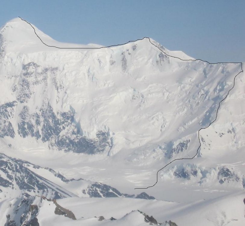
Jed Brown and I just returned to Fairbanks after making the first ascent of Mt. Moffit's North Wall on July 10-13th. The Entropy Wall (VI, 5.9, A2, WI4+), approximately 1,500m and 33 pitches, is followed by approximately 900 meters of snow and ice slopes leading to Moffit's summit. It was the most serious and commiting climb I've ever done. Some rock was poor, but some was excellent and splitter. Highlights included a perfect snow-mushroom bivy, a 3m horizontal roof, steep water-ice pillars, and lots of free climbing and aid climbing up steep cracks. More pictures to come eventually! Picture of the face: http://59A2.org/hayes/200607/route.jpg
-
Denali’s Cassin Ridge had, for me, long held a place as a route that was too technical, too big, too scary, and just too hard to even think about trying. Road trips down south, ice seasons in the Rockies, and winter aid in Squamish, slowly began to change my perception of the route into something climbable. I jokingly mentioned the route to Nick Elson after a day of dry tooling in Squamish and to my surprise and excitement he seemed just as keen to try the route as I was. Nick is a solid rock and ice climber and I knew his ability to climb 5.12 (in the gym…) would be our secret weapon on the 5.8 crux’s… I left the Rockies in February to go tree plant on the coast and make some money for the trip. While coastal planting is great for the wallet and physical conditioning it can be horrible for my psyche. In 50 days of planting over 40 were raining and our cut blocks were either just below or just above the snowline. I prayed my frozen feet and hands were a side effect of the creatine I was taking to try and put weight on for the trip. Nick miraculously sent our applications and fees in and the date was set for a May 10 arrival. I left the coast on May 5th and in a flurry shopping and packing (throwing everything in my van) Nick and I set off from Vancouver on the 4 day drive to Talkeetna. Once in Talkeetna we went to the Ranger station and prepared ourselves for a stern lecture on the dangers of climbing and the importance of safety. I nervously sat as the ranger pulled out our resumes and eyed them closely. To my surprise he looked up and said “looks like you boys have a lot of cold weather climbing experience, lets take a look at the route shall we?” The Ranger in fact, almost seemed to have more confidence in our ability to climb it then we did! Maybe he had our resumes mixed up with 2 other climbers? He took us through a slideshow of the route with pictures from the year before that I must admit, made the route look quite challenging. Acclimatization Once at base camp we sorted gear for our cash and packed up 14 days of food fuel to acclimatize on the West Buttress route. After dinner nick quickly became nauseous and promptly vomited into the vestibule. He reassured me this was standard practice for him while acclimating at “altitude”. Base camp is at 7200ft. We spent the next 5 days getting to the 14000ft camp and taking care not to push to hard. Once at 14k we set up shop for the week and dug in. Other than 110kph winds (160kph were recorded at 17k) we had an uneventful week at 14k with 2 short day trips up to 17k on the upper West Rib to Acclimatize. We spent the week reading, writing, eating, cross wording, and listening to American radio on my mp3 player. 2 weeks after leaving base we were acclimatized as we were going to get and sick of sitting in our tent day after day; despite the quality of entertainment in people watching at the 14k camp. It truly is an international jungle! There’s ALWAYS something going on up there. Helicopters flying up to pick up injured climbers, tents blowing away, team breakdowns, a guy who fell down the orient express (miraculously was uninjured), fixed line drama, craziness! With the weather forecast predicting a high pressure system building we happily packed up camp and headed back down to base camp to grab our gear and food for the Cassin. Base Camp As usual, the forecast ended up being wrong. Well, sort of. It was originally forecast to be good, but the next day was changed to a “strong” low pressure system, but actually turned out to be sunny for the next few days with a forecast of snow in the next few days. We frustratingly waited for that elusive 4 day forecast of high pressure from the north, it never came. We made use of a sunny day and climbed the SW ridge of Mt. Francis. A beautiful 4000ft IV 5.8, 60 degree snow route 15 min from base camp. More dustings of snow kept us in camp as we impatiently read the last few of our books; a depressing book about hunting and killing cocaine lord Pablo Escobar and the first 2 adventures of Harry Potters. We got our break just as it appeared Harry had discovered who had opened the chamber of secrets… Cassin Day 1 At 8:00pm that night Nick and I went as usual to the base camp manager’s tent to listen to the nightly forecast. To our surprise it was calling for sunny weather for a few days then a chance of snow and then clearing later in the week. It wasn’t the strong high pressure we wanted but it was the best forecast we’d had in a week. We also felt that after a week we were beginning to lose our acclimatization and if we didn’t go now we’d have to reacclimatize at 14k and drop 5000ft down the west rib to the base of the route; instead of going up the quicker but more dangerous Valley of Death. We quickly took down camp and discussed a few last minute gear details. 1 pot or 2? Shovel or no shovel? Fleece jacket or not? What do we need 2 pots for? 1 pot would do for our bowls as well. Nick wanted nothing to do with the shovel but it seemed I had an irrational attachment to my shovel and so ended up bringing it. In the warmth of the evening sun I left my fleece jacket and brought just the shoeler, gore-tex, and down. Neither of us brought over boots. Decisions I would later regret. For rack we brought 6 cams, 5 nuts, 7 screws, 3 pitons (#5, #6 bugaboo and a ¼ angle), and 8 slings. We brought 5 days of food and fuel for a week. My meager food was the least I had ever brought for 5 days. My food bag had 45 gu gels, 10 yogurt granola bars for breakfast, 5 sesame snaps, 5 fruit bars, 2 Cadbury chocolate bars a pack of soup and 3 dinners. We left base camp a 9:30pm and set off towards the valley of death. The valley is so called for the kilometers of serac lined valley that threaten to crush anyone who enters. In the few minutes we were at a lookout overlooking the valley from the 14k camp we saw a serac collapse and the powder rush over one of the safer spots on the route, the so called “Safe Camp”… Hard snow and a trail to follow allowed us move fast through this dangerous, awe inspiring valley. Once at the safety of the west rib couloir we set up the tent for a few hour sleep and to brew up before heading up the first crux, the Japanese couloir on the Cassin Ridge. 5 hrs later and not so refreshed we hiked the short distance to the base of the Japanese couloir and Nick started up what was one of the tougher pitches of the route; a short vertical section over the bergshrund on extremely rotten ice was a difficult and eye opening pitch. We had assumed we would be able to simul-climb the 9 pitches up the couloir but the amount of ice and rocks being knocked down the narrow gully and attention demanding nature of the climbing forced us to pitch out 9 calves burning, pick dulling, energy sapping pitches to the first and very small Cassin Ledges camp at 13600ft. This small rocky ledge is about 4ft by 10ft and just fit our bibler tent. Cassin Day 2 The next morning nicks lungs felt like they were being squeezed in a vice, and he was in obvious pain. Not exhibiting any other signs of pulmonary edema and not wanting to go down we took a rest day and hoped the problem would heal itself We ate a half dinner to conserve food. Cassin Day 3 Nicks lungs felt sufficiently good enough to continue and other than a large amount of blood in his shit that morning (still no clue what that’s from) felt good to go. One mixed pitch led to a 5.8 pitch that would take us to the start of the cowboy traverse. The cowboy traverse is a 7 pitch knife edge ridge that starts steeply at 45 degrees with steep drops on either side. The last 1/3rd of the ridge is a less steep corniced ridge that requires traversing at 60 degrees. This ridge is extremely difficult to reverse and once completed commits one to the 6000ft of climbing to the summit. Conditions on this feature vary from year to year and even within the month. It can be unprotect able snow or calf burning blue ice that takes bomber screws. Luckily we found it in nearly perfect condition with a few inches of bonded snow on top of ice screw protect able ice. The small amount of snow on top of the ice allowed us great rests and secure climbing and we were able to simul-climb the arête in 2 leads to allow us to swap gear. The winds were now picking up and snow began to fall and we decided to pitch camp at “the most spacious camp on the whole route” , a flat spot at the top of the arête and at the base of the snowfield leading to the first rock band. Cassin Day 4 A short pitch through a shrund took us to a snowfield that led to the base of the first rock band. 3 mixed pitches took us to a difficult mixed/mostly rock pitch (off route) followed by another distressingly steep mixed pitch (possibly off route). My technique of pulling on gear came to an abrupt stop when no gear could be placed to pull on. After much thrashing and swearing and a disturbingly long time later I belayed nick up. We simuled up the next 2 pitches to the top of the first rock band where a short snow slope led to, as the guide book says, a “small exposed bivy” at 15700ft. A small ledge had already been chopped and even after some more chopping by us the tent still hung distressingly over the edge by a good 10 inches. While chopping the ledge Nick put a fist sized hole in our single wall tent, possibly to increase ventilation, I assume. We anchored the tent to screws and axes and tied, mostly, everything in, including ourselves. Strong winds and snow kept us awake most of the night. Lack of snow to build a wall now left us exposed to any winds that ripped across the mountain. Cassin Day 5 By morning, blowing snow had accumulated halfway up the tent wall on the side against the ledge wall and was pushing us, and the tent, further off the ledge. The wind was now howling outside it was quickly obvious we could not move in these conditions. I boiled a liter of water each and locked ourselves in the tent. By noon the gale winds had blown most of the snow clear from between the tent and the ledge but unfortunately the snow had also acted as a stabilizing force for the tent. The winds would at times nearly flatten the tent and threaten to rip us off the ledge. By evening the snow had stopped but the winds had further increased and the situation was becoming more serious by the minute. That evenings forecast was predicting “an extreme high wind warning for the upper mountain and a strong low will persist over the mountain for the next few days. Fuck. Snow was blowing in the vent hole nick had created and high winds all day and night had shaken any condensation off the walls onto our bags. My -30 down sleeping bag was now a very heavy and expensive nylon sheet; with a frozen ball of down on either side of the baffles. Damage control, Nick and I flipped to see who had to go outside and tighten guy lines make new guy lines, move the tent in, tighten it in and try and prevent the destruction of our sole shelter. I lost. As quickly as possible I tied string and slings and equalized our tent but no matter what I did it still seemed to that the major gusts would flatten the tent if someone wasn’t bracing it. It was at this time I noticed we might have a small problem. Our windscreen had blown away. No big deal, I couldn’t seem to find the pot lid either, hmmm. My heart slowly began to race as I realized that our only pot was no longer where it had been and that all three were probably airborne over the south face of Denali. At least that’s one (or 3) things less that I now have to carry. I told Nick in a good news bad news type way and all he replied was “At least we have the stove”. Indeed. That night the wind continued to howl and we both stayed up all night with our backs against the windward wall trying to brace it and find a position comfortable enough to allow some sleep. None would work and we eventually resigned ourselves to staying up and bracing and catching ourselves dozing when a massive gust would come and threaten to throw us off. Neither of us talked much. My mind was racing. My sleeping bag was useless. I put all my clothes on and shivered in my nylon sheet. Both poles were now badly bent in multiple places. If the tent collapsed we’d be fucked. What the fuck were we going to make water in? The mental math of rapping 3500ft with one rope and sparse gear was to unappealing to think about. Not to mention reversing the Cowboy Traverse. Besides, Nick and I are both Taurus’, stubbornness is our strong point. Cassin Day 6 I woke out of a half sleep to find my lungs killing me. They felt like what Nick had described to me on day 2 at the Cassin ledges. I hoped it was from crouching all night to brace the tent but took a dex and diamox to calm my now racing mind. Some time in the morning the wind eased up and we decided we had to move. Our shovel blade would have to do to melt water in. Any water we had to melt from here to the summit would have to be melted in our shovel blade. This time consuming process took over 2 hrs to melt 6 liters. We packed up camp and headed up the second rock band. By the time we’d melted water and got moving it was the afternoon and we only went several pitches before getting to a sheltered bivy at 16500ft; the last for several thousand feet. We decided to stop here instead of risk another exposed night above the rock band. My lungs were killing with every breath and I was glad not to be gaining much more than several hundred feet elevation since the last bivy. We camped on an abysmally small ice ledge next to a rock wall but at least it offered some shelter. After repeated failed attempts to heat water enough to cook our dinner and even trying to heat it in the foil container we resigned ourselves to several spoonfuls of cold, slushy, crunchy, Mountain House Kung Pow Chicken. Motivation was gone, food was critically low. I lay awake all night listening to my lungs and my grumbling stomach. The lower half of my body hung off the ledge. Morning couldn’t come quick enough. Cassin Day 7 and 8 We debated having a rest/storm day but with no dinners, not enough food to last, and a ledge that closer resembled a sloping couch we would hardly be recovering enough to warrant a rest. My breathing seemed so constricted that I didn’t want to spend another night on the mountain. We joked it was summit or fly (as in a rescue helicopter). We spent the next few hours brewing in the spindrift and wind and then packed up with the goal of carrying over the summit to the17k camp on the West Buttress. 2 more rock pitches led us to the top of the second rock band and the end of the technical difficulties. All that separated us from the summit was 3700ft of non technical snow and rock. After a long break we set off up steepening slopes on hard wind slab to frustratingly slow knee deep wind drift. We seemed to be going maddeningly slow according to the topo elevations. Nick broke trail through a tough deep section and my wheezing lungs could barely keep up. We stopped around 18000ft to listen to the 8:00pm weather report on our FRS radio. Partly cloudy and 80kph winds above 17k was the forecast. The best it had been all week. After a Chuck Norris joke and listening to some ranger talk we set off with renewed spirits. I drank the last of my now frozen water and had a last GU gel. In the increasing cold and high winds, melting more water on the shovel would be next to impossible. We resigned ourselves to pushing over the summit. Luckily my energy seemed to be increasing and nick and I pushed hard to the summit in the increasing midnight cold. My feet slowly lost warmth and stopping became unbearable. I had to keep moving to keep them from freezing. Landmarks kept coming quicker than expected and nick and I quite quickly found us at Kahiltna Horn at 20000ft; just 320ft shy of the summit! The wind was now howling over the summit ridge our thermometer showed -30C and with the wind at over 90kph the wind-chill was down to over -65C.We ditched our packs and raced the few hundred feet to the summit. Nick told me he felt like shit, and had trouble keeping his balance. Not unusual for the amount of food and water we had consumed over the past few days but also a symptom of life threatening cerebral edema. Excitement turned to the urgency of getting down. We got back to our packs and nick flopped on his with a tiredness he’d never shown before. I took out a dex and diamox pill and he quickly took them with the last sip of his water. I yelled through the wind we had to get down and we quickly put our packs on and headed down. Unexpectedly, we found ourselves breaking trail through knee deep snow, I though this route was a highway?! We later found out that no one had summited for 8 days because of storming conditions and high winds. No shit. The pace was agonizing, my lungs would burn if I walked to fast and nick would collapse in the snow every few hundred meters. After a few hours of that we made it to Denali Pass and could finally see the first signs of people! I broke off in knee deep powder and only after several hundred meters realized there was a wanded route to our left that would hopefully offer firmer snow. I began to cut over but the exhaustion forced me to stop every few feet and collapse in the snow. Nick, feeling renewed energy in the lower elevation took over the breaking and dragged my now exhausted ass into the 17000ft camp; 17hrs after leaving our high camp on the Cassin. We set up the tent and melted some water in a borrowed pot and collapsed in the tent for a few hours. My lungs still hurt and after a few hours sleep we packed up to get to the warmer 14000ft camp where we had a fuel and much needed food cash. I scrounged some tasty waffle treats and some chocolate from a party who was bailing and nick and I savored our first non gu food in a while. We continued with renewed energy to the 14k camp and spent a long time just sitting on our packs in the warmth staring at nothing and everything. It was over. For the first time in days I felt relief wash over me. We’d made it. Stefan Albrecher
-
John Kelly has been attempting several new routes on Yukla over the past year. He already put up a new route on the Northwest face earlier in 2005 and has tried several others since. I finally got a chance to join him on an attempt at a line on the Northeast face. Our line is just barely visible under the snowfield on the far left Another better view of our route, which is just to the left of the obvious white smear under the snowfield on the left. Yukla, first climbed in 1967 via the Icicle Glacier by famed Alaskan mountaineer Art Davidson (first winter ascent of Denali and auther of the book 'Minus 148') sees little traffic due to its hearty approach and difficult access, and has probably seen less than 25 ascents, even though it is only 8 miles from the road. At a height of over 7500 feet, it is the fourth highest mountain in the western Chugach, and dominates the skyline around Eagle River. The Northwest face is one of the biggest walls in the entire Chugach, and is still, for the most part, virgin...with the exception of two or three routes. I flew back to Anchorage on Saturday, December 31st at 8 AM and was on the trail by 2 PM. We bushwacked through the tedious Icicle Drainage and finally arrived at our first bivy site in the valley at 2:30 in the morning...a great place to bring in the new year. On the way to the drainage, we met a nice girl sitting alone at the Echo Bend camp who hooked us up with some great...stuff. We really owe that girl, she made the rest of the approach go easier. We woke up the next morning in true Alaskan style, and were on the go by noon. We simulclimbed up the snow fan to the base of the virgin Northeast face and spent the next three hours chopping out an awesome bivy ledge on a 60 degree slope, 500 feet over the valley floor. All the while, small sluff avalanches continued to pour over our route-to-be. John leading pitch two. We awoke at 4:30 the next morning and were climbing well before six. It finally started getting light at 9 and we were up the first two pitches by then. John lead most of the hard pitches, which consisted of M5-M6 climbing with overhanging rock and long runouts at parts. His most amazing lead took place at the chimney, on the fifth pitch. He started at 2:45, and spent the next 2.5 hours meticulously inching his way up the virgin terrain while I belayed and shivered inside the cave. By 5:30 it was dark and John had finally lead his way up the crux and had established a belay station. After tediously following John's line and cleaning the pro, I unlodged his pack from the overhanging section and he hauled it the rest of the way up and I carefully finished the crux, wishing I could have watched him lead what he called "one of the most amazing pitches of his life," big words coming from John, who has done some big climbs in his day, to say the least, We knew we were getting close to the top of the face, where we would meet up with a lower angled snowfield which would allow us to top out and then walk off on the Icicle Glacier and then back to our high camp. I led the next pitch, which started off in a narrow hourglass below a five foot tall rock buttress that steepened to a steep snow slope, then to a 20 foot step of WI3 crumbly ice with crappy protection. I put in one snarg and a 16cm screw and continued climbing. I slowly climbed up the couloir in seemingly endless unconsolidated powder snow that dissolved whenever my hands or feet touched it, and ran down right onto John. For several hours, I went left and right, up and down, diagonal and zigzag, trying to find suitable places for some protection...but there was none. The cracks were seemingly nonexistant, all to common on the Chugach rock. I managed to get in one #3 stopper at the base of a seemingly gravity defying vertical wall of powder snow that was about 15-20 feet high and had a 5 foot tall overhanging powder mushroom on the top. I stuggled in vein for several hours, trying to find more protection and a way to surmount the powder wall. If I had had better pro in the walls, I feel I could have gotten up the wall, but I was not willing to take a lead fall on a poorly placed stopper with at least a 100 foot runout behind it. The lights of Anchorage illuminating the sky At about midnight on the 2nd, we decided to can it and retreat, figuring we were close, but still had another pitch or two to go. It was a dissapointing defeat, especially when we saw how close we were to being finished and getting our names on a new route. We spent the next 5-6 hours making a total of six rappels. I had lost my cell phone in the cave on pitch five and was convinced I would never find it again...oddly enough it was waiting for me at rappel station number four...how it stopped right there I will never know. We got back to our high camp at six in the morning, planning on walking back down to the boulder camp and sleeping there...we woke up at 10 AM with our feet sticking out of the tent and we weren't even in our sleeping bags. I still had my helmet on. We had been climbing for 24 hours straight, had both consumed less than 2 liters of water during that time, and had hardly eaten anything. For me, it was my first big experience in alpine climbing and I learned a lot. For John it was another defeat on the walls of Yukla. You can clearly see our line. It follows right up the middle, through the chimney, and then to the hourglass snow couloir. Our highpoint was just at the base of the hourglass. In different conditions, that powdersnow headwall might be easier to surmount, but conditions weren't favoring it at that time. From there it is merely a walk up. John really deserves most of the credit for the climb. He lead the hard pitches and was patient with me as I learned the ropes. If time allows, we might go back and finish the line in February. Last March, John and his friend Dan completed first ascent of the Heritage wall on Heritage Point in Eagle River, which was featured in the American Alpine Journal.
-
Chad Kellogg and I spent a few weeks in the remote Kichatna Mountains of the Alaska Range. We managed to climb Kichatna Spire by a new route. This was the eighth ascent of the mountain by its seventh route to the summit. The Black Crystal Arête is the first route to tackle the peak’s southern aspect by climbing the slender ridge that splits its south and east faces. Kichatna Spire from the Shadows Glacier. Aerial view of Kichatna Spire from the south. Paul Roderick flew us into the Shadows Glacier on the evening of July 6. Immediately upon landing we went for the route but were turned around by rain. On the third day we made a second attempt only to be stopped on pitch four by more rain. After spending 5 hours with our feet in plastic garbage bags we pulled the plug and rappelled back to the ground. A few more days of bad weather came and went as we scouted other route possibilities. Finally a splitter two day weather window arrived and we were off and running. We left in the morning of July 11 and made our way quickly to the base of the spire’s south arête. The first six pitches climbed the east wall of the feature. However, what had been dry rock before, was now drifted in with fresh snowfall from the previous day’s storm. What had been relatively straight forward pitches became quite tedious. Pitch 2 proved to be the first crux. I led a small wet roof, followed by a thin detached flake led to a super mantle-reach. Delicate moves with thin gear above a ledge finally moved into more positive terrain. Chad following up the east wall. Once on the ridge proper, a few gendarmes provided interesting route finding. The first major one we climbed in three pitches and were able to traverse around its right side just 50’ from its top. Climbing along the ridge crest. The Sunshine Glacier is in the distance. A short downclimb off the backside, led to the “Ore Chasm” – a 5-foot wide cleft that require a wide stem. The first gendarme. Chad can be seen down climbing toward the “Ore Chasm”. A few easier pitches led to another gendarme only passable by a rotten chimney on its right side. Chad led up the “Bombay’s Away” pitch – named after a huge booger of rock five times his size that flushed out of the chimney as he climbed up and stood on top of it. Unscathed, he continued aiding and climbing up huge overhanging flakes to the top. The actual ridge was pretty short lived, however, as it completely dead-ended into the upper south face. The only way to continue seemed to be a set of horizontal twin seems that led out left. Gaining instant 2,000+-foot exposure, Chad led across the thin traverse to the base of another nasty looking chimney. Chad leading the key horizontal traverse high on the route. I got the next pitch – a vertical ice-smeared chimney we dubbed “Icebox Desperado”. It might have been a brilliant M6 pitch had we had crampons and ice-tools. But with only rock shoes it proved to be an interesting mix of aid and free up disintegrating ice filled cracks. This gave way to slightly easier terrain and after a few more pitches we crested the summit ridge, just 200 horizontal feet from the true summit. We topped out on a beautiful, albeit smoky, evening, as we watched the sun make its long descent towards Mt. Foraker. On the summit looking northwest. A view to the west. Middle Triple peak is on the left. We sat on the warm and windless summit for about 45 minutes, before starting the long and dreaded descent. The 2nd rappel. We rappelled throughout the night. The crux was having to repeat a few of the key traverses with frozen fingers and toes. Repeating the key traverse just after midnight. About 20 rappels later, we returned to the Shadows glacier just in time for the sun to warm us up again. A short stroll back to camp and we were back just 25 and half hours after starting. We named our route after the most amazing black rock crystals we found on the summit ridge, some of which were upwards of 2 feet long! The next 10 days or so we spent attempting the Citadel. We spent a week in a portaledge on the peak’s east face, but were thwarted by weather and bad rock. We also made another single-push attempt on its unclimbed south ridge, but we fell short of the summit by about 800-feet (that might be considered a new route by some people. ha!) We knew our time on the glacier was drawing to an end with the rapid recession of the fern line toward our landing spot. Soon we would be camped on top of ice and after another week, we may not have been able to be picked up. So we packed it up, dialed Paul on the Sat phone and headed home.
-
Sorry this is a little long winded, but what else am I going to do at work? On Tuesday May 10th after our second attempt in as many days Gordy Smith and I summated Mt. Marcus Baker via a new route (Sanctuary Ridge). Gordy had come to me a couple of months earlier to see if I was interested in a new route up Mt. Marcus Baker. I was, and after seeing his recon pictures of the route, became convinced that even though this was a rock ridge in a range notable for its horrible quality of rock, this route could be done safely by bypassing areas of poor rock on faces below the ridge. Our trip started just 4 days earlier when we left Seattle on Saturday Morning. The flight to Anchorage was amazing with clear skies the entire way allowing rare glimpses of Mt. Logan, Mt. Fairweather and the perennially socked in Mt. St. Elias. Our approach into Anchorage also had the benefit of giving us a clear view of our objective summit, although we were viewing from the south so we were not able to see our planned route. We had no problems with transportation, bags or picking up of last minute provisions, and arrived in Talkeetna by 5 pm under clear skies. When we walked into our flight service office we were asked to get our stuff together so they could fly us in as soon as possible. We quickly packed and were in the plane 45 minutes later. Approximately 12 hours after leaving Seattle we were sitting on an isolated glacier approximately 80 miles East North East of Anchorage at 7000 ft elevation. After setting up camp, cooking, and sorting all our gear we took an inventory of all the things we had left in the rental car in our rush to pack. Luck had it that only one of these items (the handle for the shovel) was a potentially critical error, but due to good weather, turned out to be more of an inconvenience rather than a real issue. Other items left behind included nuts, and oatmeal. The following morning we packed our gear and started skiing east up the glacier to a small col that overlooked the Matanuska Glacier to the East. This col is the base of a rocky ridge that climbs 2000 ft to a glacier that makes up the summit plateau of Mt. Marcus Baker. Realizing that the climbing looked technically difficult and our pack were quite heavy, we decided to stash our gear and recon a route through the crux of the ridge which appeared to be quite close to the bottom. We headed up 50 degree ice on the east side of the ridge for approximately 400 ft and gained the crest of the ridge. From here we made an anchor (consisting of a single nut in a crack) and began scouting the rock above. I climbed just to the left of the ridge crest for about 50 ft only to come to a vertical section of shattered and horribly loose rock. After climbing back down to the anchor I headed up to the right of the anchor in a slight gully on mostly rock with patchy snow. Again after 75 ft I was stopped by very poor rock conditions. My decision to turn around at this point did not stem from the fear of pulling rock down on myself, but more in the total inability to build any sort of a safe anchor in which to retreat from if we were stopped higher up. I had decided that Gordy’s Route was not going to go in its current conditions, at least not by me. We down climbed back to the ridge and sat in the sun mulling our limited options on the steep north side of the peak. The previous evening upon landing on the glacier we had noticed another potential line in what at first glance appeared to be a giant serac threatened face. We walked up the mellow angled ridge on the north of the col to get a better view of the line and see if it would go. From this angle it now appeared to be a fairly low angled ridge that continued all the way from the basin which our camp was in, to the broad low angled west ridge of Mt. Marcus baker at 10,800 ft. With our spirits a little brighter we skied (skied for me is a relative term, which roughly translates to uncontrolled sliding on slippery sticks followed by face plants powered by the weight of a 35 lb pack) back to camp. We cooked dinner, melted snow for water, and tried to get to sleep early. The following morning we were up around 6. We left camp by 7 after an hour of melting more snow, getting dressed, applying sunscreen, filling pockets with food, etc. The previous night we had made the decision to try for the summit in a single push from camp. This would limit the loads we had to carry on the lower part of the ridge, but make for a long day. We carried enough to keep us alive over night just in case we did not make it back to camp. This included down jackets, plenty of food, and most importantly a stove for melting more water when we ran out. We skied directly south from our camp zigzagging up the slope and around crevasses to a point approximately 1000 ft above our camp, and directly below a large ice wall that gained an almost horizontal ridge several hundred feet above us. At this point we took off our skis and donned crampons. I led out and crossed a poorly bridged crevasse and gained the lower section of the ice wall below the horizontal ridge. I crossed over a sub ridge and did a climbing traverse to the right side of the main ridge. From here we continued very close to the crest of the ridge through calf deep snow crossing bridged crevasses on the ridge with little difficulty. After 1200 ft of 30-40 degree snow slogging we reached an open crevasse which we had spotted from camp as being a potential problem. It was still bridged, albeit poorly, and after punching my feet through, gave up walking across and swung my tools over to the higher side, and pulled the rest of my body over. Gordy made a similar move to get across this the only real technical difficulty of the lower ridge. This is also the only place where we placed any protection to protect us from falls. Above this the climbing steepened for 400 feet and became hard ice and neve snow. At 10,800 ft we gained the west ridge of Mt. Marcus Baker. From this point we walked along the mellow wind blown ridge with amazing views to either side. The ridge was good cramponing over hard snow and ice. Between us and the summit pinnacle lay a sub peak labled on the USGS maps as 12,200 ft. We climbed up this peak on hard ice up to 50 degrees, and reached the top with our altimeters reading 12,000 ft. (Our altimeter read accurately on the summit, which made us believe that the altitude of this peak is inaccurate on the map). From the top of this peak we dropped down about 450 ft to the base of the summit pinnacle. Gordy and I dropped our packs and had a short conversation about how tired we were and the possibility of spending the night out (which would have sucked). After agreeing that we had plenty of food, water, and clothing we continued to the summit. We climbed up and right on hard ice. The ice gradually steepened to about 70 degrees and then suddenly fell back for the final few feet of walking to the summit. At 4 pm we were standing on the summit under clear, but brown hazy skies which limited visibility (we believe a fire near Homer was the reason for most of the haziness). After taking a few photos we quickly began our descent. We descended by setting tools as anchors and lowering the first and then having the second down climb the ice. After six rope lengths the angle was easy enough to walk facing out and down. Due to the soft snow on the lower ridge we were able to walk face out for much of the ridge which speeded our descent considerably. Still we did not reach our skis until close to dark. After crashing repeatedly down the final 1000ft we reached camp at midnight. My overall impression of the route is very good. Both Gordy and I believe this is a very viable alternative to the standard Matanuska or Knik Glacier routes. Not only is it shorter, but it is a very enjoyable route. Part of the lower ridge allows close up views of huge hanging glaciers and high rise building size seracs, without the fear that they will fall on you. All of the ridge is protected from serac fall making it a very safe route. The upper ridge allows views of the Chugach range and its Glaciers to the North and College Fjord to the south. All in all a very enjoyable route.
-
I just returned from a great trip in the Alaska Range. I started out flying into the Mountain House with David Gottlieb. We walked down the hill and camped in the middle of the Ruth Amp., a spot I highly recommend over camping in the Gorge due to more sunlight and much less wind. The weather and conditions were great so we immediately went for the Japanese Couloir on Mt. Barill. This was a great natural line up the east side of one of the Gorge peaks. We descended the same way. After a rest day and continued good weather, we decided to have a look at the South Face of Mt. Dan Beard. Not knowing much about the route, we followed the main couloir up the left hand south ridge, and then continued up the ridge above. The snow conditions quickly deteriorated in the afternoon sun and after a few route finding errors, we descended around 500 feet from the summit. Not feeling complete with the climb, we took another rest day, and then with better knowledge of the route, climbed it to the summit just as the first big storm hit. We descended in the raging storm and returned to camp for five days of tent time. The weather finally cleared a little and with only a few days left in the trip, we decided to race up to the West Fork for a look at the Southwest Ridge of Peak 11,300. We moved camp up to the West Fork and in the foggy mist we met Jedi, who had just climbed it and gave us tons of good info. The next morning dawned clear. We were torn between waiting a day to let all the new snow settle and letting a clear day go by. We decided to go for it. We summited that evening and spent an amazing night on the summit and descended the next morning. The next day we skied out to the Mountain House and were flown back to Talkeetna. After a few rest days I picked up my next climbing partner Daniel Zimmermann from Switzerland. We flew into Kahiltna Base Camp intent on Hunter’s North Buttress, but this never materialized due to the very warm and moist season the range had. Instead we focused on smaller objectives. We headed up the first morning to look at the Mini-Moonflower, but seeing a party already on it we shifted our focus to the South Face of Peak 12,200. We climbed through 2000 feet of rock bands then broke out onto a long snow slope above to reach the summit. We descended the dangerous Southeast Face back to our skis. Our next mission was an attempt on the Mini-Moonflower which saw us up 9 pitches before the spin-drift nightmare occurred. Upset with the general trend of the weather, we decided to climb the Southwest Ridge of Mt. Frances one day regardless of conditions. It snowed the entire day, but we found this climb to be one of the better base camp area climbs, very similar to the Southwest Ridge of 11,300. After a rest day, a small break in the weather opened up so we ran up and did the North Couloir of the Mini-Moonflower. This as well proved to be an awesome moderate route up a really cool feature. The next eight days were stormy and depressing. We almost flew out at one point but were lured into the promise of a short high pressure spell. We left for the West Face of Kahiltna Queen one clear evening. It started snowing after three hours of climbing but we pushed onto the summit in a bit of a bad storm. Descending was interesting amidst the rash of avalanches but we returned back to base camp unhurt and flew out that evening. After a bit of rest and a relaxing boat trip on Prince William Sound with some good friends, my next climbing partner Chris McNamara came up. The weather had been marginal for another week in the range and we flew into the Ruth Gorge one morning in light rain. However, just a few hours later the weather cleared. Chris looked over toward Barrill and said “I want to go climb that. Now.” So just a few hours after landing, I found myself at the base of the Cobra Pillar of Mt. Barrill. After a frenzy of climbing, 15 hours and 10 minutes later we found ourselves on the summit. It was our first climb ever together – what a way to warm up. A shitty descent down the Northwest slopes allowed us to walk all the way back around that morning and crash in our tent for the next four days for the biggest storm of the season. After surviving three days of torrential rain we headed down the Gorge for a look at Werewolf and Hut Tower. Not liking the line on the Werewolf, we climbed up the Southwest Face of Hut Tower, a line I had done before but was certainly worth repeating – 10 pitches up to 5.10 on some of the better rock in the Gorge. Our next objective was the West Pillar of the Eye Tooth. This might well have been the best alpine rock climb I’ve ever done. The rock is good, the climbing interesting, and the line is aesthetically amazing. We topped out on the last rock tower (don’t be fooled by the route topo!) with snow leading to the summit. Without snow gear, this was to be our high point and we started the long descent, getting our rope stuck no less than five times. With some time left but no fingertips left, we decided to have a look at the ‘small’ (1800 foot) Stump formation on the side of the Wisdom Tooth. The left of two major dihedral systems on the south face caught our attention. The climbing was incredible and the rock outstanding, until it abruptly exited left, off the face and dead ended into a steep gravel wall 600 feet below the summit. This was apparently the route of the first ascentionists and we were rather disappointed as we rapped off. After another day of rest we decided to straighten the route out and complete it direct to the summit. We headed back up and climbed several new pitches of amazing terrain. We haven’t yet named our new variation on the South Face of the Stump (Wisdom Tooth), but it is one that shouldn’t be missed next time you’re in the Gorge – 12 long sustained pitches up to .11a. We set up the route with bomber descent anchors with clean pulls. With our time was coming to an end and our fingertips really worked we pulled our big sleds up to the Mountain House (which Chris maintains was the crux of the entire trip), and had a beautiful evening flight back to Talkeetna. And for the crux of my trip: On July 8, Michelle O’Neil and I were married on the Pika Glacier in Little Switzerland. We flew up with two airplanes with most of our family and some close friends for a beautiful ceremony amidst the great peaks of the Alaska Range. We had a big reception in Talkeetna that evening. Michelle Puryear and I flew back into the Pika the next week. The weather had definitely changed back to a wet pattern. Our first objective was the West Face of Middle Troll. We found the climbing to be quite fun as we simuled the route in one pitch. At the top I conned Michelle into scooting out to the edge of the huge diving board feature for a neat photo op. Two days of rain ensued but a clear morning dawned and we got an early start to climb the South Face of The Throne. Being rather uninspired by the routes on the right side of the South Face, we climbed the rounded ridge to the left of the South Face Gulley. The climbing again was solid and fun, and we were pleased to find that the summit ridge had no snow or cornices, allowing us to summit via the upper West Ridge. The next day again dawned clear so we decided to take a shot at the East Buttress (Gargoyle Buttress) of the Royal Tower. The climbing was interesting; not quite as solid or straightforward as the other climbs, and the routefinding was tricky. The weather was decidedly going down hill all day and on the 11th pitch, about 2-3 from the buttress top, we decided to bail. After the first rappel it was raining. Toward the bottom the rain was intense and so was the rockfall. The bottom three pitches are quite threatened from the gully on the right. We pulled our drenched bodies back into camp without incident. After another day of rain, we decided to try one more peak. During a very short weather window, we were able to climb the South Ridge of South Troll. Twice we set up rappel anchors to bail, as waves of rain came over, separated by sunny breaks. At one point we made a hasty rappel, only to reclimb the pitch. After we summited, we realized we were in for it. We quickly rappelled the north face then climbed over to the West Face of the Middle Troll to continue that decent line. Hail, rain, wind, and thunder buffeted us, but we again made it down safely. We flew out that evening during a brief clearing in the weather.
-
Summary: Brook Alongi, Fred Beckey, and I recently climbed a previously unclimbed 7530ft peak in the Neacola Range via a 3000ft, 40-50 degree snow coulior on the south side of the peak. Details: Fred and two others attempted to climb this peak two years ago. The two guys started climbing the coulior starting at midday on a warm day against Fred's advice. They made it about halfway up the coulior and were then washed down to the base of the coulior by an avalanche! No injuries, but that was the end of that attempt. While the peak is only ~70 miles SW of Anchorage, and is visible from the southern end of Anchorage, getting there is no easy task. We took a wheeled plane from Anchorage to a small gravel strip on the west side of Cook Inslet which is primarily used as a service station for the offshore oil rigs. We were then picked up by a helicopter and deposited on the glacier at the base of the route. We set up our tents, and started climbing. The route was straightforward and we stayed to the climber's left side of the coulior. The weather began to deteriorate as we approached the top of the coulior and a moderate snowfall with some wind greeted us when we reached the col. Fred was very tired at this point and decided to sit at the col and wait while Brook and I continued on toward the summit (we estimated about 200' vertical away at that point). I led up through some granite blocks and put in a piece of rock pro or two. We were trying to move very fast at this point because Fred was cold and nervous about being left alone, tired, on an untraveled peak, with 3000' of steep snow separating him from our camp. Brook soon joined me and we looked over a slight rise and saw the summit about 100 yards away and less than 100' above us. The snow was falling more heavily at this point and it was getting pretty blustery, so we decided to turn around and start getting Fred, and ourselves, back down. There were really no technical difficulties between ourselves and the "true" summit, so I consider our effort a "summit". If you don't, that's fine. We reversed our steps down the coulior with LOTS of face-in downclimbing and putting in pickets as running belay anchors since we were pretty tired at this point. A few pics of us descending: We got back to the tents after 15 hours on the go. Fred was pretty beat, but Brook and I hoped to do some more climbing in the next few days (unclimbed rocks/peaks everywhere!), so we went to sleep looking forward to some faster-paced activity in the future. This was not to be the case however as a storm rolled in and we spent 5 days huddled in our tents being pummeled by rain, wind, and snow without much pause. I think we had a total of about 3hrs of time over the course of those 5 days that were pleasant enough to get out of the tent for more than a pee-break. We did lots of reading, playing cards, sleeping, and listening to the rain patter against the tent. FUN! Finally the weather broke! Note whiskey: We used the satelite telephone to contact the chopper and initiate our retreival/rescue. We were so elated about the nice weather that we started drinking whiskey and inventing "glacier games". Here are the results as I remember them from my whiskey-affected state Event/Winner Ski Pole Javelin/Me Propane Canister Shot-put/Brook Ice-axe tomahawk throw/Me Half-eaten Horescock Hammer Throw/Brook Fred was not interested in participating in our silliness, but if he had, I think he would be a natural for the horsecock toss. In any case, we finally got out of there and flew home. We considered many potential names for the peak including "Horsecock Peak", "Mount GeorgeBushSucks", "Mount Snugtop", and several others, but settled on the more-likely-to-be-accepted-by-the-USGS "Mount Chakachamna" in reference to the large lake with that name just north of the peak. Chakachamna Lake is visible at the top of the picture. Our mountain, "Mount Chakachamna" is the point labeled 7530 at the bottom right of the picture. Our coulior is on the south side of the peak. There are lots more unclimbed peaks/rocks in the area like these cool-looking buttresses: although the rock quality did not look very good with a few exceptions. Thanks to Fred for planning the trip and making it happen. Thanks to Brook for the great partnership, patience, and calm demeanor. Thanks to Jim Sweeney and Art Davidson for their hospitality and for sharing their stories.