

Bronco
-
Posts
3853 -
Joined
-
Last visited
-
Days Won
19
Content Type
Profiles
Forums
Events
Posts posted by Bronco
-
-
Hi, welcome to the forum. The weather in May on Rainier is fickle. I've certainly been stormed off in May. The best weather for Rainier is typically the end of July and August. Unfortunately this is past the season for the Curtis, Liberty and Ptarmigan routes. Too late in the season and you won't have enough snow/ice on the route. Too early and you're wading in chest deep snow if the weather allows an attempt. If you're traveling from out of the area, it's a huge challenge to line up conditions, partners and weather. My suggestion is to have a solid plan B east of the Cascade Mountain crest like Mt. Stuart or something in the Stuart Range.
It's also unlikely the roads to access the Mowich Lake and White River trailheads will be open in early May to further complicate it. The park has to plow them out each year.
-
Such a bummer. I saw Rick for a couple of injuries over the years, he was just a super nice, humble person. We even talked about climbing a couple of times and he never mentioned that he had completed the Seven Summits. RIP
-
That's what I'm talking about, go Kit!
-
No, there's still good turns to be cranked!

-
Go see a good boot fitter for your boots. Evo in Fremont has some good ones. I have Atomic Backland Carbon boots that have been punched and molded to my wide forefoot and high instep. Boot fit is the most critical element of your setup. Do not skip this step. There are a ton of boots out there, I prefer a good range of motion on the cuff in walk mode for hiking, skinning and occasional climbing.
I'm a little heavier than you but essentially the same size. My primary BC ski for the last decade are Dynafit Manaslus in a 169cm length with Dynafit Superlite bindings. The bindings can be annoying to some because they don't have a "flat" setting and the heel is always a little elevated when you're skinning. This setup weighs 108 oz per ski. I wouldn't go any lighter personally, these get bossed around in hard conditions. I have a fatter set of touring skis that weigh 166 oz each but are a lot more fun to ski.
Lighter skis, boots and bindings are faster on the ascent but can be a liability on the descent. You have to find what works for you.
-
These are awesome TR's keep them coming!
-
11 hours ago, Eric Gilbertson said:
I’m working on climbing the Bulgers in winter
Wow, this got my attention!
Awesome TR, thanks so much for posting it here!
-
Sounds like a standard winter attempt. Routes that go easily in a day in the summer can be way harder and frustrating in the winter.
Good job taking advantage of the stable weather over the weekend and thanks for sharing the photos!
-
18 hours ago, JasonG said:
That is moving!!! Well done, surviving and zipping through the traverse so quickly.
As you are painfully aware, I don't tend to set the pace. It was my much faster partner who was running an ultra marathon a few days later and was super dialed with his climbing kit/fuel/rack.
-
4 hours ago, JasonG said:
Oh? What was that story @Bronco?
Me and a partner were attempting the TFT and took the SE Face of Torment. We had let our guard down after pulling over the 'schrund and were still roped-up while scrambling up the SE face feeling like we'd passed the difficult problems. I don't remember if my partner kicked it off or if it was just the rope dislodging it but a bunch of microwave sized blocks started bouncing down above me. There was nowhere to run without pulling my partner off so I found a tiny little depression close by to press into and pull my pack up to protect my neck. Miraculously the rocks missed me and didn't chop the rope anywhere that we could detect it. I think it shook up my partner more than me, I remember him shouting my name like he wasn't expecting me to still be there with him. We did complete the Traverse quickly enough to get BBQ in Marblemount that evening. So I got that going for me.
-
 1
1
-
-
Great photos as usual and good work finding a route without crowds. Like many folks, I had my closest call on Torment with rockfall. I remember saying to myself, "make yourself small, make yourself small" while cowering behind a tiny outcropping with my pack pulled up to cover the back of my neck. Definitely not dad approved.
-
1
-
-
Nice work, how was HWY 2 traffic on the way home?
-
I thought new bolts are prohibited in Washington Wilderness areas. Did something recently change?
-
I'm curious, which exit did you use?
-
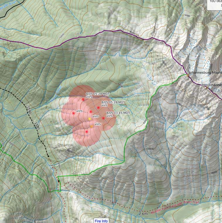
More fun with a new fire on the backside of J-Burg.
-
No kidding, bring the tissues in case it's "dusty" in the theatre...
-
You guys made the right call to stay put until light. The slabs between you and camp have been the site of several accidents, some fatal. Good job on the climb!
-
Here's a link to current USFS closures. No change at Washington Pass but the Pasayten has real limited access to anything up the Chewuch River Drainage.
https://www.arcgis.com/apps/webappviewer/index.html?id=8e69381e35144962a835ee59aafba153
-
On 7/16/2021 at 3:16 PM, Kuato said:
Looking up the lake to the Columbia Glacier, there is a giant horseshoe of cliffs surrounding the glacier. The only easy way to the glacier is walking up the side of the lake to the base of the glacier.
From the summit of Columbia this weekend, we could see there's a steep slope you can scramble down from Monte Cristo Pass to the Columbia Glacier. The moats are pretty significant right now including the snow finger in the gully you'd normally use to get from the glacier onto the west face of Kyes. It was a little surprising considering the high snow pack we had this spring but I guess that heat wave did more damage than I figured. Glad you found a way down Monte Cristo!
-
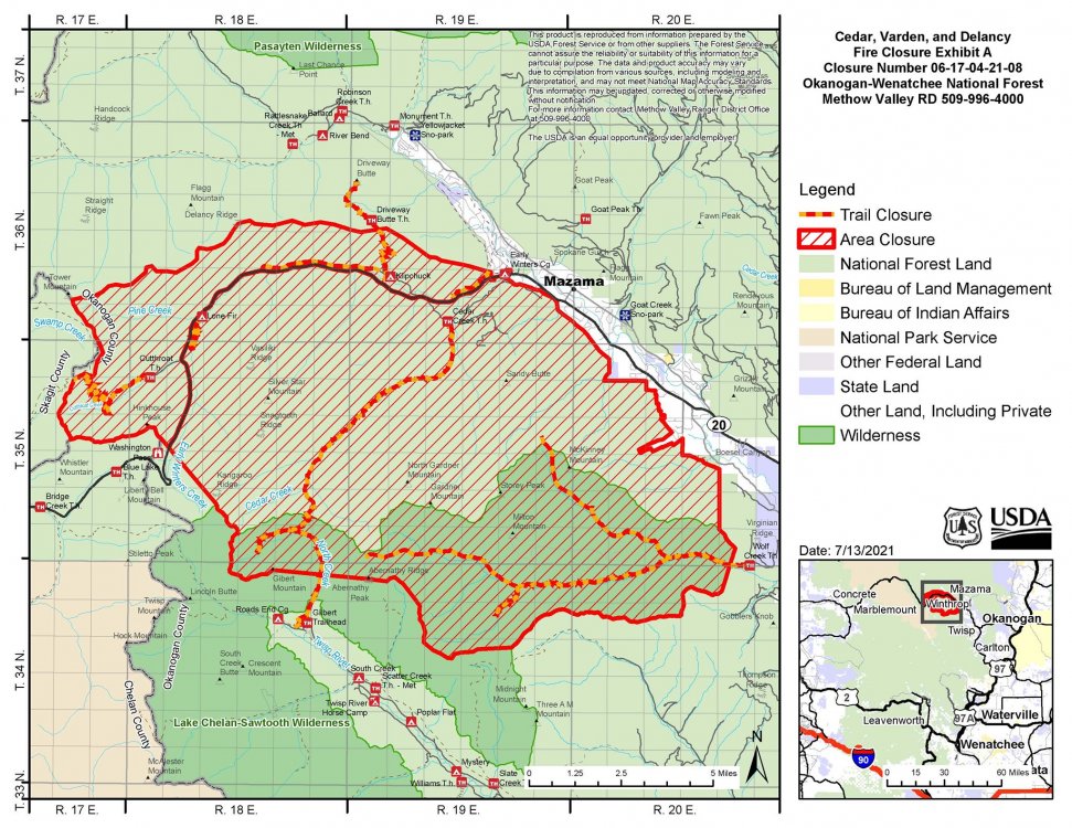
If you're planning to do any climbing in the Washington Pass area, it'd be wise to check up on access. HWY 20 is closed just East of Washington Pass and probably will be until we get some significant precipitation. This likely means September or October before you can get through. Areas that are definitely closed include Cutthroat, Silver Star, Wine Spires, Spontaneity Arete and the Gardeners. Also affected is area North of the Twisp River drainage. Though the Liberty Bell are is technically just outside of the closure, I'm not sure it's a great idea to head there right now with the close proximity to the fire operations and potentially placing additional stress on resources and first responders. Same goes for Goat Wall and crags up Lost River Rd as this area is not technically closed but is subject to a Level 1 evacuation order.
This is a map of the current USFS closure area:
-
 1
1
-
-
[TR] Goode - NE Buttress 07/02/2021
Fake news!
-
You should reach out to Burdo. If he doesn't respond, the developers are likely not done and don't want folks in there while they're finishing up. I don't know if Burdo is the sole poster behind it but I understand he's involved with the FB account "Mazama Rocks". You might start there.
-
Didn't Beckey commonly use a stick for eating and after dinner hygiene?
-
I rely on gel blocks and shots and just wash them down with water between actual breaks where I can pop them out to eat/brush/re-insert. I hate these things and look forward to being done with them!

Ptarmigan ridge- Rainier early season
in Climber's Board
Posted
Here's a link to road status and projected opening dates: https://www.nps.gov/mora/planyourvisit/road-status.htm