Leaderboard
Popular Content
Showing content with the highest reputation on 05/02/22 in all areas
-
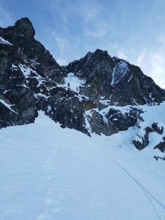
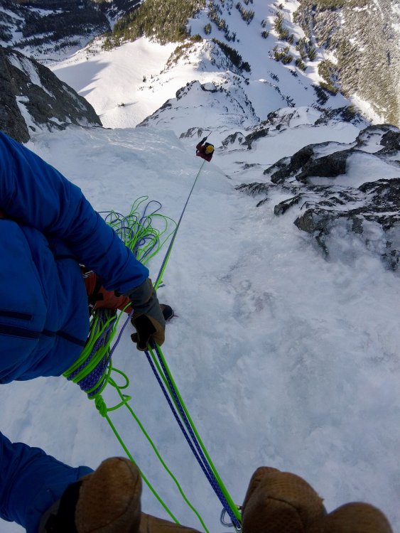
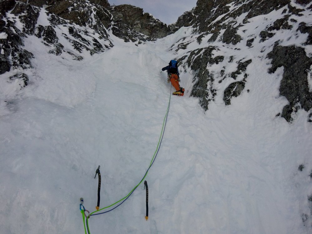
Trip: A Peak - Knickerbocker and the Bull Moose (FA) Trip Date: 04/25/2022 Trip Report: With a short good weather window and high hopes Earl and I set off into the Cabinets to see what we could find on the North Face of A Peak. We left the trailhead under warm and sunny skies and enjoyed the dirt trail and glacier lily's for the first couple miles. It was definitely spring and we wondered if maybe we were too late in the season already. But about halfway in on the Granite Lake Trail we started hitting snow and by the time we arrived at Granite Lake there had been multiple postholes. Thankfully we arrived an hour before dark so we had time to scope the face of A Peak with binoculars. There was still ice on the Thunderdome and 3 Tiers but it was looking warm and rotting. The north face of A Peak looked good however and we soon decided on our line. The goal was to climb up a main couloir that slices up the face and then follow the corner system above to the summit ridge. After a short night we were hiking out of camp by 3:15am. A couple hours later as the sun rose, we had crampons on and were booting up mostly neve snow in the entrance couloir. The couloir climbing was steep but easy and I was surprised at how good the ice flows were that poured in from the left wall. My partner Earl had climbed these ice features to the snow field above and then connected a line to the summit ridge 3 weeks ago as a solo first ascent (Bull River Prowler, M4, AI3, 600m). At the top of the couloir the real climbing began. We followed the corner system above mostly containing mixed rock with a few patches of ice in the corners. The gear was generally good but the climbing slow and tedious cleaning snow off the rock or testing holds for loose rock. On the 3rd pitch Earl was cleaning some loose rocks when the snow mushroom he was standing on collapsed. He was suddenly left dangling from one hand on a great steinpull. Somehow he kept his composure and reestablished his feet on the rock before taking the fall. After 4 pitches of engaging climbing we reached a saddle in the buttress that had been on our right. From here the obvious line continued another 4 pitches up the corner systems above. These pitches were all easier in difficulty and had more ice. The 6th pitch was probably the most aesthetic if only because it started on a thin ice traverse that allowed for some great pictures. By this point on the face we had an incredible view of the basin below and even across the ridges towards the town of Libby. The last pitch ended with a chimney, then a "birth canal" squeeze to some cornice digging to reach the summit ridge. All in all it was a proper adventure. We were 12hrs climbing the 8 pitches and 18hrs camp to camp. The decent was pretty straightforward because we could see. We hiked the ridge to the south towards Snowshoe Peak until we found a steep slope between cliff bands to descend back down into the basin to the east. From there it was a couple miles and several thousand feet of postholing down the basin and back around to Granite Lake. We called our line Knickerbocker and the Bull Moose in reference to both the Wool Knickers that Earl wore on the ascent as well as the moose that continually likes to post hole and destroy our trail into granite lake. It was an awesome experience to be able to put up such an amazing line on A peak. The climbing is quite good and in my opinion on par with many of the classic climbs I have done in the Ruth Gorge of AK (in terms of difficulty and quality). Knickerbocker and the Bull Moose, IV, M5, AI4, 600m. Looking up at A Peak from Granite Lake in the fading light. Roughly the route we took. Passing by the route that Earl had put up 3 weeks before called Bull River Prowler. Our route continued up the couloir and then the corner system above. Looking down the couloir from the top as we rack up for the mixed pitches. Earl starting up pitch 1. Looking up the top half of pitch 2 which turned out to be the crux. Looking down from the top of Pitch 2. Earl starting up Pitch 3. Earl starting up pitch 5 where the climbing got easier. Enjoying some thin ice on the beautiful Pitch 6. Me looking up Pitch 7 before starting out. The upper half of the route was mostly this terrain...fun moderate mixed climbing. Looking up the beginning of pitch 8 with the cornice looming overhead. Earl and I on the summit ridge while on the decent with the true summit directly behind us. Gear Notes: We had double set of cams from .4 to #2 with single #3, 8-10 pins (heavy on the LAs and KBs), set of offset nuts, set of tri-cams(doubles in the 2 smallest sizes) and 5 screws (all short). We placed a lot of pins and the tri-cams came in very useful as well. In addition we wished we had a couple more small cams below .4. Approach Notes: Hike the Granite Lake Trail to Granite Lake in the Cabinet Mountains. From the lake hike up 2000ft to the base of the North Face.2 points
-
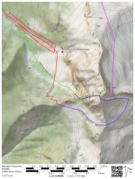
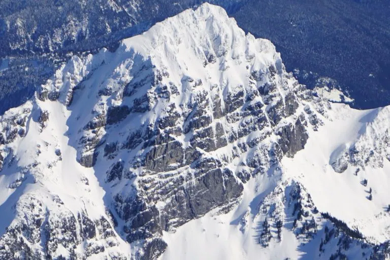
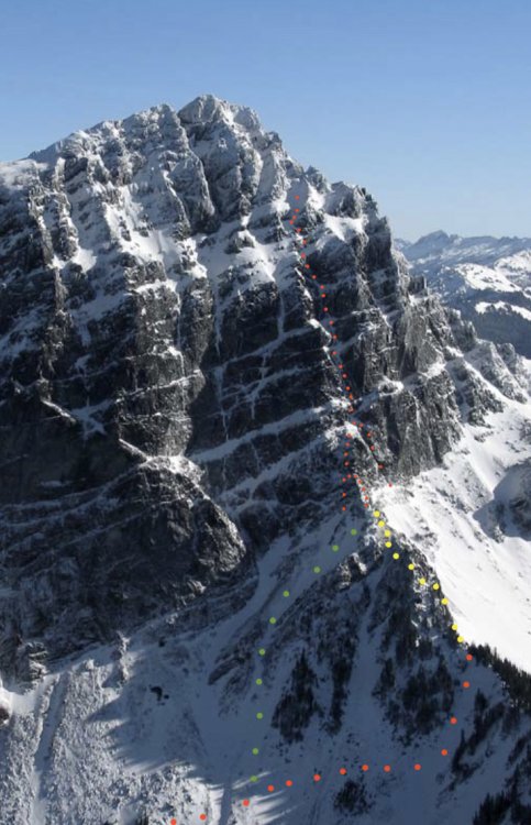
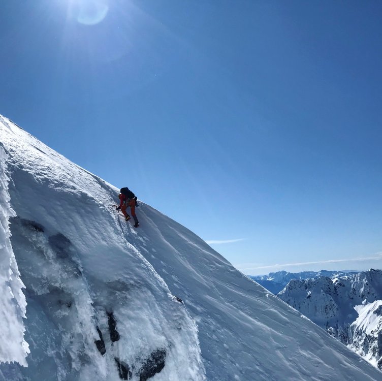
Trip: Sloan Peak - Superalpine Trip Date: 03/15/2020 Trip Report: This past Sunday, Tavish and I climbed Superalpine on the west face of Sloan. After the incident last time I wanted to get back and climb the route to the top. We didn't quite tap the top due to wind slabs on the upper face. I'm going to mix up the order of this one and put all the route details first so those who are looking at climbing the route can use this page for reference. Kyle also has a great page about our first climb of this route with excellent photos and maps. https://climberkyle.com/2020/02/28/fa-sloan-peak-superalpine-wi3-4-1000/ Approach: Both times I've climbed this route we parked at the spot where 4096 merges from Mountain Loop Highway. 4096 had deadfall and snow which made it undrivable but if you can drive up a bit before there's too much snow or deadfall then that will cut off some distance. Follow the road (easy skinning or walking) to where the Bedal Basin trail forks off to the left. Take this trail through the trees for a few miles to where a slide path up to the left becomes obvious. This slide path leads to the base of Full Moon Fever. Skinning up this path is straight forward and takes you to the base of the West Face. A long traverse to the south will bring you to a ridge that leads to Superalpine. Here, options exist. Assuming you're on skis, I recommend leaving them at the base of the route and descending the route. There is also the option of descending the corkscrew route and wrapping around the south side to meet that ridge (it would be heinous to boot) or carry skis and descend the glacier to the North East that will eventually allow you to meet back up with road 4096. The ridge can be tricky. Once you decide your strategy, the ridge will still be engaging. It's not scary, just steep with deep snow. The Route: However you opt to get to the base of the route, you are first presented with 2 (or 3) options for pitch 1 to access the couloir itself. The first time Kyle and I climbed a WI4 step on the climbers left. It was vertical for 2-3 body lengths and fairly thin. This past time Tavish and I thought it looked even thinner so we scrambled the ridge further up (M2-3) then did one pitch that wrapped around to the second step of the first pitch and ended at the same place. Either way, you need to get to the bench at the base of the obvious weakness in the wall. A third option may exist to the climbers right of the ridge. Perhaps it's even easier (if so it would bring down the grade of the route to Wi 3-3+). Pitch 2: This money pitch leaves from the bench and provides a full 60m of steep sustained Wi3. Protection was generally good for this pitch. Make sure to go a full 60m if you are planning on simul-climbing higher on the route. Pitch 3: This middle section of the route was lower angle and about half snow and half low angle ice (wi2) for us. We found good pro every hundred feet or so. This section makes a lot of sense to simul-climb. Both times we did a 100-150m block. There was good ice at the top of a chimney-like feature, or, if you've saved enough screws, the next step had good ice on the right for us. Utilize rock gear to conserve screws through this section. Pitch 4: From the end of the last pitch, this is the last section before exiting to the face. Depending on where you belayed, you’ll either have a steep snow slope to a curtain or be climbing right onto the curtain. This curtain is where Kyle fell on our first attempt. This past time, I found a sub-vertical weakness (wi3/3+) on the right side of the curtain (not the smear further right which provides a good belay). However, when Kyle fell, there was spin drift blasting the section I climbed so he went further left where it is more like Wi4 with a heinous top out with sugar snow and hollow ice over sugar. I found good protection in the weakness but Kyle didn’t find good pro further left. Approach this pitch with caution, don't be afraid to back down. I found a great ice screw belay on the right about 20ft above the curtain. Another option to avoid this pitch if it is unclimbable is a snow ramp to the left. See photos to spot this snow ramp. This would avoid all of the upper curtain and put you on the upper face, however, it is steep and exposed and unprotectable. As with the whole route, use your judgment. This isn't just alpine climbing…. It's Superalpine! The steeps above: Look at photos of the big face above the route (and have them with you). There are a variety of options that exist to climb this large feature (700 vertical feet). When I climbed it most recently, we found deep unconsolidated snow, wind slabs, alpine ice, and rime features. This section is shared with the corkscrew route and is very committing. There are a lot of ways to get lost, falling is never an option and it's mostly unprotectable. Very reminiscent of the upper slopes of the Cosley-Houston on Colfax. If the snow is consolidated and secure, it would be a total blast to climb, if not, then maybe it should be avoided. On the first attempt we bailed due to injury, and on the second attempt, we bailed halfway up the face, after converging with the corkscrew route, due to thick cohesive wind slabs. The descent: Descending should be straight forward. Downclimb the steep snow, and rap the route. We took 5 or 6 raps to get down the whole route each time. There is no down climbing once you’re back down to the top of the curtain pitch. Each rap is a full 60m and ends at good ice, providing plentiful V-thread options. Other descent options exist as mentioned in the approach section but this option is quick and straightforward. Ski out the way you skinned in. Rack: In the conditions we found, 8 or 9 screws including a 10cm or two makes sense. Rock pro isn’t super plentiful and there is a lot of ice so we took 4 cams, 4 nuts, and a pin or two. This is probably what I would recommend. If you try it earlier, then beef up the rock gear side of things, the rock is quite solid in places. Hopefully, people get out and climb this thing! It is like the NW Ice Couloir on Eldorado but way bigger. Lots of ice, great setting, not too heinous of an approach. Tavish and I did 17hrs c2c. We were not rushing but we weren't lollygagging either and we were ~350ft from the top. Kyle made this topo with the options. My opinion remains to descend the route. Good to know your options. Here is a topo I made on a John Scurlock photo of Sloan from February 2005 (low snow/ice year). Red dots show the route (note the three options for the first pitch). Yellow is the tricky ridge. Green is an approach that could avoid the tricky ridge. Aerial photo from Shane in February 2020. The ramp to avoid the curtain is obvious in this photo. Now, onto the story from yesterday. Tavish picked me up at midnight in Bellingham after an hour or two of restless sleep. We drove through Darrington and onto Mountain Loop. His Prius handled the road like a champ and by around 2 am we were packed up and walking up the road. I was in crocs since I forgot running shoes, they did the trick (they're the next big thing in climbing for sure! Breathable, waterproof, sorta, ultralight, cheap, comfy, and climb 5.12 with ease.) Anyway, we started skinning after about a half-mile and cruised up to the Bedal Basin Trail in about 90 minutes. There was a fresh half-inch of snow showing bobcat (?) tracks following the existing impression of skin track. From there we encountered a mix of booting and skinning in the trees, mostly skinning but lots of skis on skis off. There was a slight impression of the existing skin track (probably from Michael Telstad, thanks!) that we followed and got us where we wanted to go. We skinned up the slide path below Full Moon Fever and the snow transitioned from a few inches on a crust to a nasty wind board. I knew it would be bad since I skied the white salmon the day before but I was hoping to find wind scraped, not wind loaded terrain on this aspect since it would be indicative of the upper slopes. We continued to the tricky ridge as it got light, left our skis there and put on actual boots (last time I climbed in ski boots, this was better). While we transitioned, we got pretty cold. We brought big puffys since the freezing level was 0ft and it was probably 5 or 10 degrees. Fortunately, the sky was clear and there wasn't a breath of wind. We hurried through that transition and started booting up the ridge in all our clothes. Bobcat? Not a dog, not very big... It was slow going and I punched through to my hips or deeper at several points. We were toasty warm by the time we were at the base of the route. The left-hand variation Kyle and I took last time looked much thinner so we opted to climb the ridge above us and see if that would go. We soloed up easy rock to an impassable wall. Luckily we could traverse left and rejoin the first pitch from last time. Tavish led that and gave me a meat belay to the first bench. I led the next pitch which provided a full 60m of sustained ice. Very fun! Tavish took off from there and we simuled around 150m. It's so fun to move quickly, especially when it's that cold! We got further on this simul pitch than last time and I got worried that Tavish was going to get to the spot Kyle fell before I could warn him of the dangers. Luckily, he didn’t. He belayed from a thick clear smear, right of the curtain. I led the curtain up a weakness on the right and it wasn't too bad. Above that, there was an ideal ice bulge on the right to belay from. This was great because it provided an easy spot to transition from climbing to soloing and eventually to rappelling. I rigged a V-thread while Tavish soloed up the snow above. After threading the ropes, I took off after him. I caught up and he looked concerned. I could also feel the snow was not ideal. We could see snow plumes ripping over the ridge above us and the snow we were on was a cohesive wind slab. We downclimbed a bit and then went up further left through some tight constrictions and ice. Above that, there was another wide-open snow slope and we found two distinct layers in the snowpack. The top here was about 6in thick styrofoam-y feeling wind slab. Bellow that was another 4in thick older windslab, and below that was sugar. We had probably already gone too far but we decided to call it here and started down. Me on the second pitch (SO GOOD) Tavish getting to the top of pitch 1. Tavish taking off into the simul section. Tavish on the upper slopes It's hard to turn around so close but we were certainly riding a fine line with zero margin for error, given what was below our feet. Down climbing steep snow isn't fun but we got it done and got to the ropes. The raps went smoothly and we found great ice at the base of each 60m rap. The last pitch had to be broken into two raps last time, both off pretty small trees, so this time we tried another option. We went off a little more south off a slightly bigger tree and did an exactly 60m rap down rock that got us on to snow. We post holed in wet sun affected snow to our skis, and the rest of the descent went smoothly, albeit, pretty slow since we were tired. We got to the car before dark for 17hr c2c. Tavish on the final rap. Lots of ice above Full Moon Fever... Anyone interested?? That's it for now! Feel free to reach out with more questions! Sorry, I don't have more photos from on the route it's self. I hope everyone is staying safe and healthy. Gear Notes: See Rack Section Approach Notes: See Approach Section1 point

