
Leaderboard


Popular Content
Showing content with the highest reputation on 07/26/19 in all areas
-
Trip: Cordillera Blanca, Peru - Tocllaraju - NW Ridge (D) (and others) Trip Date: 07/09/2019 Trip Report: I've posted a few trip reports on my site for my second trip to Peru's Cordillera Blanca. This range has many incredible objectives, relatively easy logistics, and is CHEAP compared to high altitude climbing areas elsewhere. Here's my report from Tocllaraju: https://spokalpine.com/2019/07/26/tocllaraju-6034m-northwest-ridge-d-ai4/ Gear Notes: Some screws, two ropes, pickets can be bought in Huaraz. Approach Notes: Make the donkey carry the good stuff2 points
-
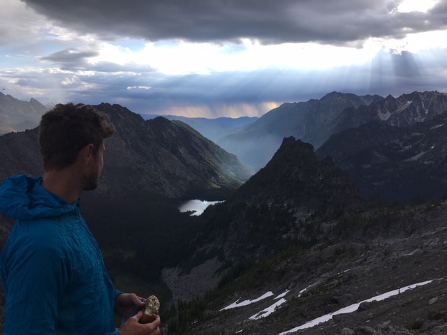
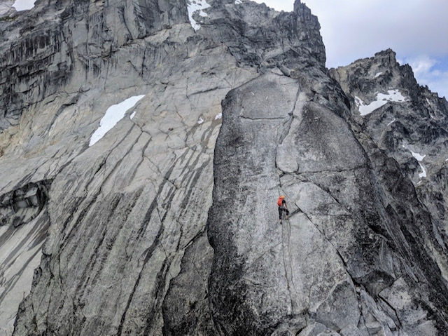
Trip: Mount Stuart - Upper North Ridge via Stuart Glacier Trip Date: 07/23/2019 Trip Report: On Tuesday, July 23, my friend Alex and I climbed the Upper North Ridge of Stuart via the Stuart Glacier and notch, car to car in 18.5 hours. I've never posted a trip report before, but I thought I would now that I've climbed the ridge twice and learned a few things - the first time climbing the complete North Ridge two years ago. We made all kinds of mistakes on the complete North Ridge at that time, spending an extra day on the mountain. I wanted to climb the ridge quicker and smarter with a good idea of what to expect. Although Alex doesn't have a lot of alpine experience, he's an endurance machine and a great climbing partner. We left the car at 3:20 a.m. after spending the night in Alex's cozy Honda Element. Topping off our water at Lake Ingalls, we could see lightening flashes in the distance to the south. As we crested Goat Pass it looked like Rainier was getting blasted. We hit the Stuart Glacier a little over four hours in. Almost at the end of the glacier traverse, the thunder and lightening were very close together and we were getting hailed on. We huddled together on a flattish scoop to let the hail pass, weighing our options. Before too long it looked like things were clearing so we headed up the gully to the bivy notch, arriving there at about 9:45 in good spirits and with more blue sky. Alex and I mostly simul-climbed to the gendarme with a few belays set up. We climbed the gendarme in two pitches, as normally done, and hauled packs up both pitches. There were some issues with the axes getting jammed, but we were able to free the jams pretty easily. I was feeling worked at the upper section of the first gendarme pitch and pulled through on a few pieces (the mental crux for me). I find the second gendarme (off-width) pitch much more enjoyable. The right forearm jams feel secure and the exposure on that pitch is exhilarating. There are two fixed pieces on that pitch - one on the initial steep face climb and the #4 that's been there forever. After the gendarme we passed the spot where my friend Gabe and I had to bivy two years ago. Glad to move past that! There's an airy traverse shortly after which looks way harder than it is (two years ago we used the rappel slings to go into the gully and picked our way back up some less enjoyable pitches to the top). The traverse led to a fun 5.7 hand-crack that felt super secure, then one more airy traverse a little above that and the summit at 4:00. It felt great to put our sore feet into tennies as we picked our way down to the false summit and Cascadian Couloir. (Two years ago I started heading down the first couloir - what a dumb mistake that was!). Make sure you use caution on the top entrance to the couloir. Everything is pretty unstable but then leads to some easy plunging through dirty scree. Scree trails eventually disappear, and then come and go through the couloir. After making it out of there we finally found a solid water source at the first creek crossing on the Ingalls Creek Trail. After a brief rest there my body started to rebel. It's amazing how, when the body doesn't have to be on guard anymore, it can start to bonk. I had a hard time controlling my heart rate even on the flat trail and tried to get calories and water down. It was a slow slog for me back up to Longs Pass, which we hit around sunset, and our adventure culminated in a windy, tired cruise back to the car, clocking in at 9:50. Alex still had enough energy to drive all the way back to Bellingham while I passed out. A few lessons I've learned on this ridge (one of the best alpine climbs I've ever done): Do not underestimate the scale of this mountain. The approach is long, the ridge is long, the accumulation of a lot of fun climbing moves starts to wear you down, and it takes a lot of mental concentration over a sustained period of time (including all the way down the couloir where there are opportunities to slip or cause rock fall, and it would not be fun to descend that in the dark). It's a committing route. Once you get high on the ridge, up and over is the way down. I've bivvied high up with very little food and water, and it wasn't a fun experience. A lot of parties find themselves with unplanned bivies. Respect the mountain! If you don't bring a stove, you may not have any water sources until the bottom of the couloir. That's a long stretch (for me, it was a little over two liters from Lake Ingalls, all the way up and all the way down the couloir to the first creek crossing). Be thoughtful about water. Don't forget to pause along the way and enjoy your setting on the ridge, which is one of the most spectacular places I've ever been. Attached pictures include Alex looking at distant storms, Alex on ridge between notch and gendarme, Kevin on slab with crack just below gendarme, summit photo. Gear Notes: One 60m rope folded in half for simul-climbing and hauling packs over gendarme, rack: singles to 3" with an extra .75 and small set of wires and hexes, 9-10 slings, ice axes, crampons Approach Notes: Southern approach from Ingalls Creek Trailhead
.JPG.dd9e42f3ab0a20032fbfdbf5bbba8f8c.JPG)
 1 point
 -
Trip: Glacier Peak Wilderness - Dakobed Range Circumnavigation Trip Date: 07/13/2019 Trip Report: Did a nice two day solo circumnavigation of the Dakobed Range. Started at the White River TH, went up the Indian Creek Trail (completely overgrown, nearly impossible to follow) and took the PCT to White Pass. Then went into the Whitechuck Basin, over Kololo Peaks, down the Honeycomb Glacier, beneath Tenpeak into the Napeequa Valley. Bivied this pass before tagging Neyah Point in the morning. Took the brushy trail through the Napeequa and up over Boulder Pass and back to the trailhead. It totaled about 50 miles and 12k ft gain. All but four miles (PCT section) of this route were either off trail or on brushy trail, so the mileage was a little more difficult than one might think. The terrain from Kololo Peaks to the Napeequa was pure magic, some of the most remote, stunning scenery I have ever seen in the Cascades. Nothing about this route is too difficult, but there is substantial low angle glacier travel and a bit of tiring side hilling beneath Tenpeak. https://climberkyle.com/2019/07/13/dakobed-range-circumnavigation/ The off trail section of my route. 8 ft tall brush on the Indian Creek "Trail". Deer near the PCT. Nearing White Pass. Tarn in the Whitechuck Basin. On the Whitechuck Glacier. Honeycomb Glacier. Honeycomb Lake. Tenpeak Tarn. Butterfly Lake and Neyah Point. My bivy at Butterfly Pass. Sunset on Glacier peak and Butterfly Lake. Marine layer flowing over Butterfly Pass into the Napeequa. Dakobed and Tenpeak from Neyah Point. Following the stream into the Napeequa. Cirque of the Butterflies - a truly magical place. The Napeequa River. Grassy meadows don't tell the truth... slide alder! Boulder Basin. Gear Notes: Trail runners and poles. You might want crampons, ice axe, helmet, glacier gear depending on conditions and your safety levels. Approach Notes: Terrible, terrible bushwachking. The Indian Creek Trail was miserable.1 point