


philfort
-
Posts
1163 -
Joined
-
Last visited
Content Type
Profiles
Forums
Events
Posts posted by philfort
-
-
Will the fees collected stay in the park? That would be nice and I'd be more apt to pay the fees if they were. It would be nice if they could then afford to do something like, oh, I don't know, say REMOVE THE WINDFALL FROM THE BOSTON BASIN TRAIL. That windfall--especially through the old avy slide area--has obviously been there a while. But nooo, can't clear that. Too busy finding people to hassle and cars to ticket.
Or too busy rebuilding the parking lot. What is up with that? They've done all these renovations at the Cascade Pass parking lot. The dirt path connecting the two parts of the lot is now wide gravel walkway with stylish stone walls. In fact the whole parking lot has stone walls, and the beginning of the trail has been re-routed (I suppose the first 10 feet of the trail was too steep or something
 ). They really moved some earth around. Who knows what that cost - what a freaking waste of money.
-
Note that the East Ridge Route should not be confused with the East Ridge Direct Route. Both are misnomers
I don't like those names... it should be NE ledges, and East Ridge (not East Ridge and East Ridge Direct). Or maybe NE ledges and SE ridge.
What does "East Ridge" have to do with the ridge anyway, it just crosses over it and goes onto ledges.

-
Yes, as in pbelitz knows that it has not.

-
I just pray that the
 will turn to Jesus instead...
 -
You should try to eat lunch there though. It's only 5$.
It's kind of a trip. You sign a little hymn, and they make funny announcements. The bread and soup were good. An accordion player came dancing through while we were eating.
All-you-can-drink coffee too.
-
It's a very laid-back place and people are friendly. Sort of a new-age hippy in-touch-with-the-earth kind of feel... though maybe it's different if you're spending the night there instead of just eating and running...
The busses are waiting for you when the ferry lands at Lucerne (although make reservations in case it's full, like one guy said).
-
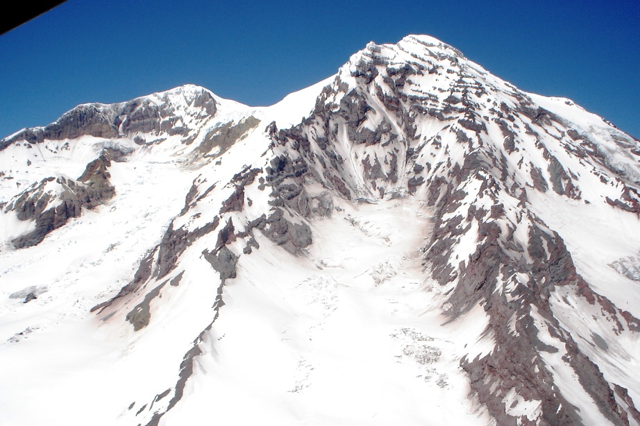
route - the upper parts are a sweet angle to ski, definitely under 40 degrees, but those lower parts right now, this time of year -- bow to the person who charges that!
Looks clean on the far left and right (maybe there's nasty multiple-bergschrund-heinosities that aren't visible in the betamax though)
-
Well now that you went and got yourself a betamax photo like that, with it lookin' SUPER-PHATTY, I'd say you're pretty much obliged to go ski it Phil.


Oh yeah, sweet photo man!
OMG that looks good... haha, maybe I'll ski it tomorrow then meet up with you guys on Sunday... haha , yeah right.
Might have to take a day off next week or something... hmm. Anyone? Hope it doesn't melt too much...
-
(hope this doesn't get deleted because it isn't climbing gear...)
I have two Corgan tickets for sale, for the concert this Monday July 18 (Moore theatre). I can't go (climbing related). I paid ~80$ for the pair, PM me an offer :-)
(before this evening)
-
Does anyone have a recent pic of the Coleman Headwall?
-
1 battery in my Canon S50 = 250 to 500 MB of photos.
Sounds like they've improved the battery life in the S50. I get only about one 128MB card full of shots from my S40 before the battery dies.
My D70 is much more efficient, I guess because there aren't moving parts to retract the lens, and the LCD screen is off most of the time. I've probably charged the battery 4 times in the 15 months I've had it.
-
Cool - what's with all these aerial "recent conditions" route photos... it's great! Blake/Mike Gauthier, keep it up!
Klenke's Dark Peak
Gee what's that big peak behind it?
(note: Copper and Fernow are visible way left in the background)
-
Mike, thanks for the photos, they are really cool.
Do you have any close ups of the area above the S-shape gully on the south tahoma headwall? (i.e. how the gully would connect to Point Success). It's hard to see in there.
(strictly for armchair usage of course
) -
Sergio, you didn't bring your snowboard?

-
Hasn't it been sunny the past 3 days?
Where did you see a slide come down?
-
If you check this website:
there are sure to be some recent trip reports from Baker around then.
-
I think Kam's line of the map is a little misleading. We just reversed the same route we took in.
It sure was a slog getting in and out of there - it was all I could do to keep up with Kam and Sky, and my legs are still very sore!
-
Impressive achievement, but it seems like a pretty contrived one (like, I had no idea anyone was trying for this record, and who cares). Whatever floats your boat I guess.
-
I think JR's pic more accurately shows the potential for skiing one or both of these couloirs, "real" winter avy conditions notwithstanding.
Sky, Kam and I launched a scientific expedition to Robinson yesterday, and after careful analysis, Sky and I verified the skiing potential of this route.

-
fyi, I saw the east ledges from far away today. They still looked very snow-covered.
-
Is it visible in this Scurlock photo?
http://www.pbase.com/nolock/image/40166101
Is it the secret crack in the shade in the middle of the pic, below which you can see an apron?
-
The summit of Cheam - it was a weekday.
Heh heh... me too.
What is it about Cheam?
-
Thanks! Ended up going to Maude instead...
-
It looked fine last weekend from Paradise. Rocks at the bottom, but I think they are avoidable?
[TR] Mixup- East Face 7/17/2005
in North Cascades
Posted
Did this route today - it was a nice day in the mtns, perfect temperature, and several goats who didn't seem interested in my pee .
.
Moat access is still easy, but the climb on loose dirt to the col is gross. I almost fell into the moat when rocks collapsed beneath me.
I stitched up the 4th class real good - I suck . But the staircase scrambling was great.
The Mixup Arm climbers path is in the best shape I've ever seen it - a cakewalk.
We were dumb and took a 30m rope. Would have been nice to be able to rappel more than 15m