geosean
-
Posts
220 -
Joined
-
Last visited
-
Days Won
51


geosean's Achievements
")


-
 Nice write-up, even though I've never heard of any of this it's cool to see!
 -
[TR] Nooksack Tower - Beckey-Schmidtke 07/23/2023
geosean replied to geosean's topic in North Cascades
Hey @Thomasp99, I'll PM a track to you but it won't help on the rock since the amount of variation form right to wrong is small relative to gps accuracy. Once on route it's all feel. #1 rule is stay left after you get onto the rock. It's pretty hard to go too far left until you are close to the summit, then you go up. -
best of cc.com [TR] Cascade Volcanoes - Bike-athon 06/06/2025
geosean replied to traildirt's topic in Mount Rainier NP
Wow, just wow. I've considered 5 volcanoes in 5 days before, but with a car!... and I thought that might be too much; and I consider myself extremely fit. I can't even imagine the level of mental fortitude this took. Well done. Thanks so much for an amazing trip and a great report. Maybe this just came at the right time in my life but this was a spectacular read; I laughed, I cried, nice work. Pizza and cake for breakfast says a lot. -
Yeah, we were really surprised at the bug situation. We all brought bug nets and deet, but never really used them much. The bugs were about as bad as the Cascades in July/August. I'm still confused about it, maybe just a good season, or possibly reverse sandbagging by Alaskans to keep people out (but I doubt it). I think we just got really really lucky.
-
We just walked through everything with our shoes on for the entire trip. We never had dry feet while we were hiking. You stop and take long lunches with your socks off to dry out your skin, then again when you get to camp. We took plastic bags to line our shoes with so that you can walk around camp with wet shoes on and dry feet. It works really well. This experience has really changed my attitude about river crossings and wet feet.
-
Home to Dome - 7 day bike to climb on the southern end of the Ptarmy
geosean replied to Lucas Ng's topic in North Cascades
Nice work, really great effort solo. So is there no glacier anymore just NE of Spire Point? Like on the main Traverse route? I've only been there in spring when it was all snow. -
Trip: Seefar Peak, Brooks Range, The Long Way - East Gullies From Marsh Fork To Dalton Highway Trip Date: 07/28/2025 Trip Report: TLDR Version/Intro: Me and 4 buddies went to the Brooks Range in Alaska for 12 days of hiking through one of the largest wilderness areas in North America. July 28 to Aug 10. We had a blast and it went great. We got flown in by a bush flight, walked along many river valleys, hiked up a talus pile peak and then through the wilderness, across rivers and over hills to the Dalton Highway where we got picked up by a commercial shuttle service that drove us back to Fairbanks and the World. Long version: Day 0: Drive from Bellingham to Seattle, Fly from Seattle to Fairbanks on Alaska Air (duh), van ride, Uber ride. Walk around town, hit a bar, Thai food. Beers in the hotel room. Day 1: Fly to Coldfoot on Wright Air, slight delay due to missed flight (don’t believe the hotel that you don’t need to be early to Wright Air, they take their business very seriously). Immediately upon landing in Coldfoot we jumped into prop plane the same age as my parents and fly with Dirk of Coyote Air into Upper Marsh Fork landing strip on the Marsh Fork of the Canning River. The flight was incredible, frequently with wheels just clearing ridgetops and flying the terrain up and down valleys. Extremely scenic, caribou and sheep. Upon landing there was much exclaiming and pointing and backslapping. Once we got settled down and the final packing completed we hiked up valley. Warm, patchy sun, overnight hard rain. Glorious, glorious, glorious! I got a good chuckle out of everyone later admitting that they were forcing down the nausea the whole bush flight and hiding it from the others. 5.5 miles, 2.5 hours. “Rainy Camp” Day 2: Hike up Marsh Fork, cross into unnamed very upper East Fork tributary of the Ivishak River drainage. Camp at headwaters. Hard day, with technical talus and side-hilling above cliffs and raging water. The river was running pretty high from the previous night's rain so walking in the canyon bottom was not an option for us, otherwise this would have been easier. Cool and misty with rain. Amazing, just like home but nothing like it at all at the same time, so great all around; we expected weather, didn’t rain enough to get wet. Much exclaiming about the scenery. 12 miles, 9 hours “Frosty camp” Day 3: Awoke to frost on the tents and plants. Hiked down canyon to junction with upper east fork of the Ivishak, down river past multiple small confluences, easy walking. Over interminable ridge with tussocks (our first!) to Ivishak River main stem. Camp in a “hay field”. Bluebird sun and warm, 2 long great breaks for lunch. Much exclaiming about the scenery. We pushed hard on this day to set ourselves up for a potential summit tomorrow assuming the weather held out. We didn't want to get stranded up high looking for a campsite with no water. 16 miles, 11 hours “Hayfield camp” Day 4: Ascended Ivishak valley toward Continental Divide, turn south to climb Seefar Peak via dogleg east gully, awesome snow in first gully, then major talus slog to the summit. Amazing time spent on the summit, warm but breezy. Lots of cool fossils in the limestone. Descent to the south and west terrible talus, so we bailed off the ridge early to Wind River valley. Made camp. Amazing dry tundra camp next to river. Shoes and socks dry at camp! First time since 5 minutes into the trip. Bathed in river and washed clothes. Bluebird, sun, warm. Much exclaiming about the scenery. A good time was had by all. 10 miles 4000', 10 hours “Swimming Hole Camp” Day 5: Hiked down Wind River, saw wolves with puppies, then later moose which led us into a lousy tussock field, camped in side creek. Very mediocre spot, but extremely close to water and some dry wood, so we had a fire and drank margaritas to enliven the spirits a little. It worked. Much exclaiming about the scenery. 14.3 miles, 7.5 hours “Margaritaville Camp” Day 6: Up wind River tributary, saw a grizzly with two cubs, a heard of sheep way up high, and a lone wolf across the valley making quick work of the talus. Up a unique talus-ey canyon, over two passes, one being the Continental Divide, down a tributary of a southern fork of the Ribbon River. Great walking most of the time. We got showered on twice, but mostly sunny. The area where we looked to camp was somewhat brushy with knee-high vegetation and it took a bit of looking to find a good campsite, eventually made a spot work quite well with great moss and blueberries. 13 miles, 8 hours “Barefoot camp” Day 7: Nice enough weather early, quickly turned to rain, then hard rain, despite the Inreach weather saying it would improve throughout the day. Misery. Trudged up to beautiful lake, too windy and cold to enjoy it. Saw wolf puppies briefly. Over pass separating the Ribbon and Accomplishment Creek and down to tundra on other side, just past dangerously slick boulder field. Dove into tents soaked through. Very cold and wet. Lunch in tent, nap. Whiskey helped spirits a lot... at least in my tent. Less exclaiming about the scenery today, though everyone admitted it would have been great if we could have enjoyed it. 8 miles, 4 hours, no breaks. “Sunny dry happy fun camp” Day 8: Woke to fog but no rain, weather improved dramatically throughout the morning. This was clutch since our base layers were completely soaked. First thing in the morning everybody got ready to hike then leapt into our wet clothes and immediately started walking quickly to warm up in an attempt to dry out some clothes. Down Accomplishment Creek, up side creek over a pass with lots of caribou antlers, half way down canyon on other side to camp. Beautiful country, lots of exclaiming over the scenery, sunny and warm, dried out everything. Decent walking. Saw moose, wolverine. Drizzle just before camp. “Sewing camp” due to a near catastrophic pack blowout. 9.5 hours. 16 miles Day 9: Drizzle, fog, cool. Down interesting puzzle canyon, that was tons of fun to figure out, left side, right side, in the creek, does it go? It goes! Saw a griz at a distance, then across a big river, nameless east tributary of the Sagavanirktok, (tough, fast crossing), hardest of the trip. Slogged up a tussock hill, to canyon, over pass and down to Sag valley, mediocre camp, not many options. We were told that the Sag was a tough crossing that kills people from time to time, so we were excited to get a look at it from up high. I had done a lot of satellite and map reconnaissance of the entire route and had picked out an area of the Sag that is quite braided, hopefully making for the easiest crossing. I had read a few scattered reports of people who crossed just a couple miles further north and had to use rafts. “Lumpy camp” 12 miles, 7.5 hours Day 10: Foggy AM, then sunny and warm. Across the Sag! It ended up being not that big a deal, but it helped that we were on day 10 and river crossing 1 million +/- a couple hundred thousand. Up the valley wall to an amazing broad sunny saddle with rolling fog, for a tea break. We were on a plateau above the confluence of the Atigun and Sagavanirktok Rivers. The fog started to break up after break, we walked slowly; some bad weather was predicted today and the next couple so over the previous few days we had hustled to make sure we could get across the Sag before the rain set in. Unlike the previous days, the weather report ended up being pessimistic and we had great afternoon sunshine. We strolled through tussocks to camp on a sunny alpine tundra slope. Amazing day. Surprise sun! Everyone tard sailed all their gear out on the tundra to dry out everything. Dry socks even!! The low tundra around camp made for great lounging and camping, and beautiful. The sun and sense of accomplishment really made the light on the hills glow that long afternoon. “Kick Ass Camp” 5 miles, 5 hours Day 11: Hiked off the plateau to the Atigun River, up the river valley to the road, road!? Long road walk to Galbraith Lake camp. My knees hurt after the 8 miles of road for the first time in the entire trip. Mostly cloudy with sun patches and a short drizzle. Surprising amount of traffic on the road, saw a civic! Fire and celebratory attitude at camp. “Galbraith Lake Campground” 6 hours 15 miles Day 12: Woke up leisurely, lounged around, day hike to West Galbraith Peak, tea and coffee on the summit. Camp time, eating everything that was left. Mostly cloudy, mild. “Galbraith Lake Campground” 5 mi, 4.5 hours Day 13: Lounged in the tent, rain and drizzle, picked up by van at 11. Wes from Dalton Highway Express picked us up in a beater 15 passenger van. Two entrees and a beer at the truck stop in Coldfoot. Food at the farthest north truck stop and bar in America was cheaper than in Bellingham. “Hotel Camp” 10 hours in the van, zero walking. Photo credits to Mike Graw. Gear Notes: backpacking gear, bear spray, rain gear Approach Notes: Airplane, deproach by van.
- 7 replies
-
- 10
-

-

-

-

-
HAHAHAHA, how true. I already want to go check it out. Thanks for the post!
-
Hi, I read an article that talked about the Firey's et al climbing the north buttress of The Rake in the Picket Range, but I can't find any more info about it other than red Fred saying that most of the rock climbing is solid class 4 and easy class 5. This is suitably vague to pique my interest but also not make me too excited to go there and give it a shot. Has anyone done it / know more about it / want to tell me to shut up and just go do it? I'm not looking for play by play beta, just basic info on the difficulty so I don't go out and epic or get skunked. Also interested in info on other routes up the Rake besides the east ridge... Thanks! Also, I don't know where the names come from but I personally find The Blob to be a bit disrespectful of a decent looking mountain. Maybe the moniker "blob" could be applied to something in Colorado?... Iowa?
-
This has been revived by a TR post elsewhere. Thanks for the beta, maybe I'll check this out. I've been up Sloan a couple of times but never thought about rock climbing, sounds fun.
-
[TR] Seahpo / Cloudcap Peak - NE Ridge 07/05/2025
geosean replied to geosean's topic in North Cascades
The scenery was indeed amazing around Icy @JasonG. Camping between Icy and Seahpo was top notch! Great place for a camping trip even if you're not climbing. -
[TR] Seahpo / Cloudcap Peak - NE Ridge 07/05/2025
geosean replied to geosean's topic in North Cascades
Hahaha, I did have that thought when we were descending. -
I saw that photo, but I hate it, it makes the buttress look terrifyingly steep! Thanks, amazing shot.
-
Nice trip, thanks for posting! If that had been you plan it would have been a fantastic outing, too bad about not getting you first choice though. It's good to know about the couloir bypass also. Someday I'll pass through that way. On another note, do you know anything about the north butterss of the Rake? Beckey says 4th and low 5th. I'm intrigued but can't find any info except that the Fireys did it in '74.
-
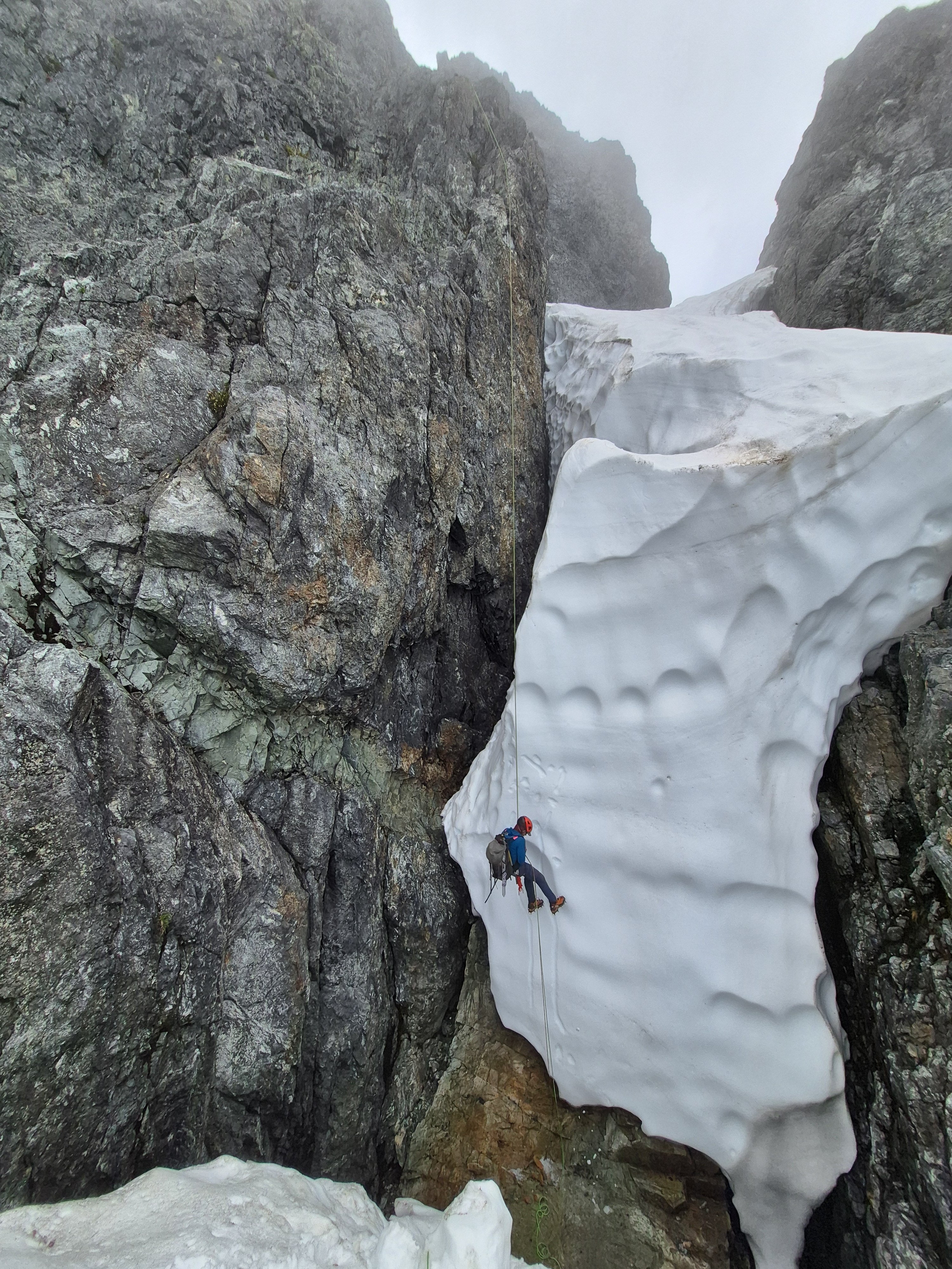
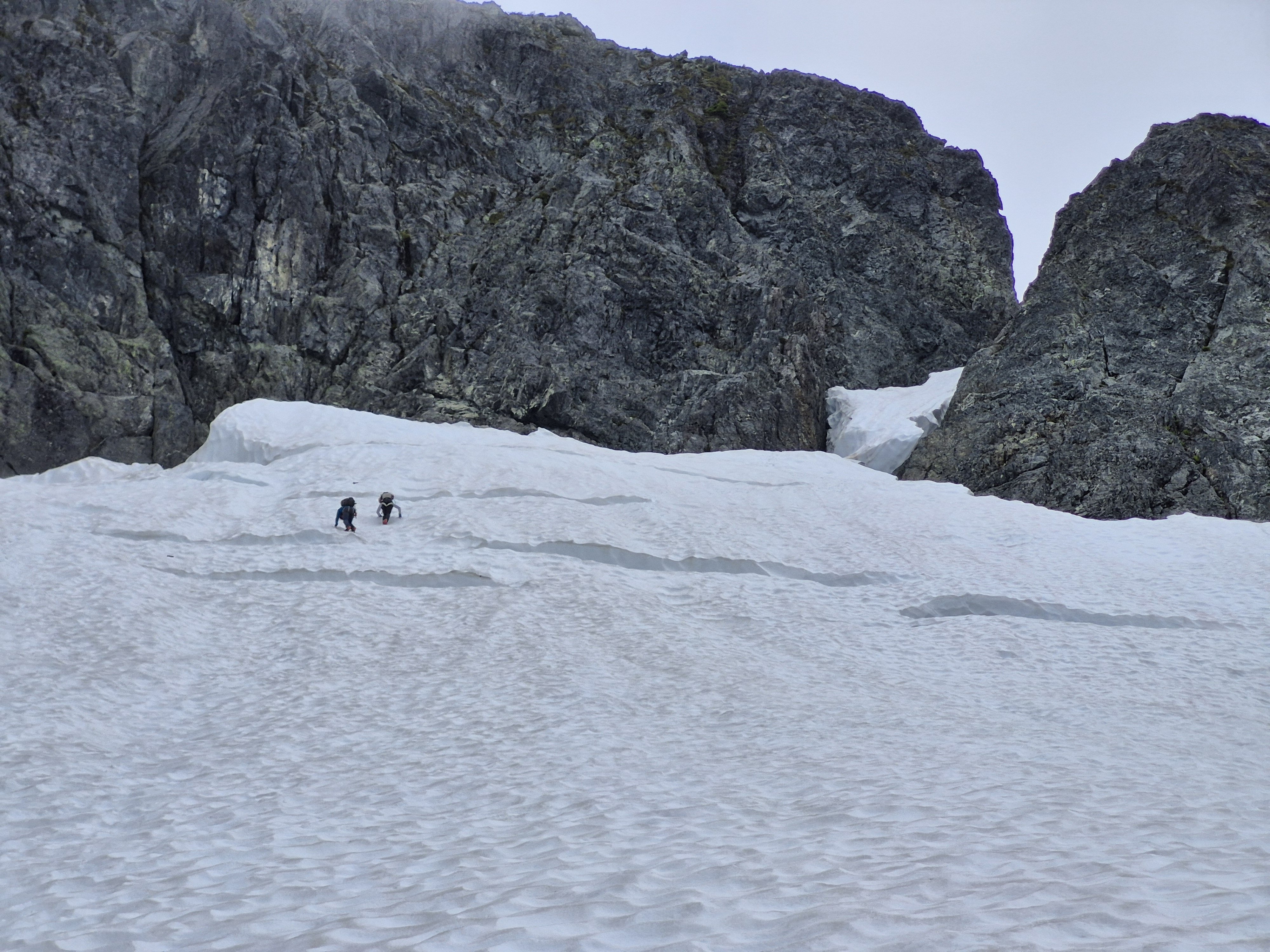
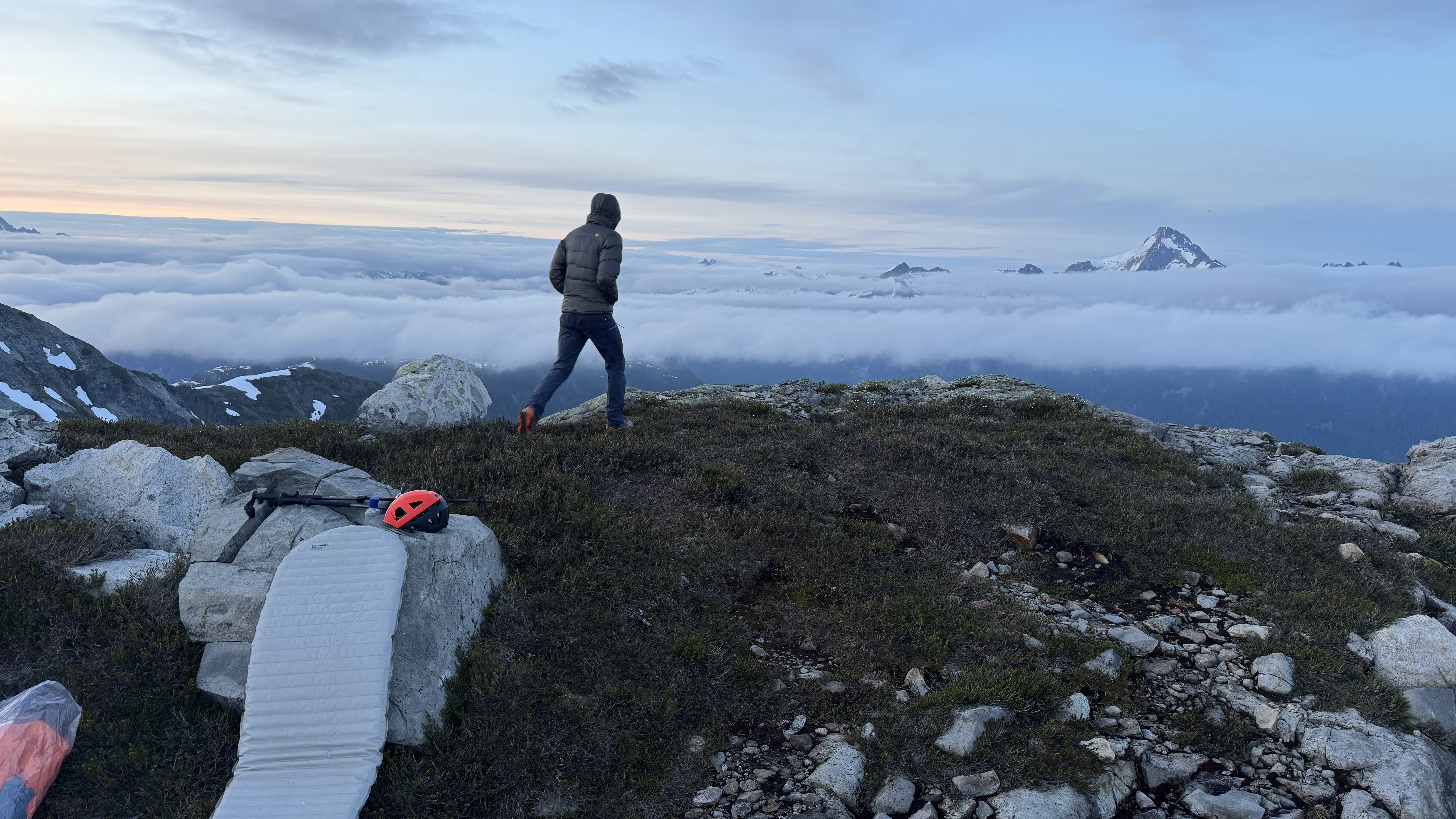
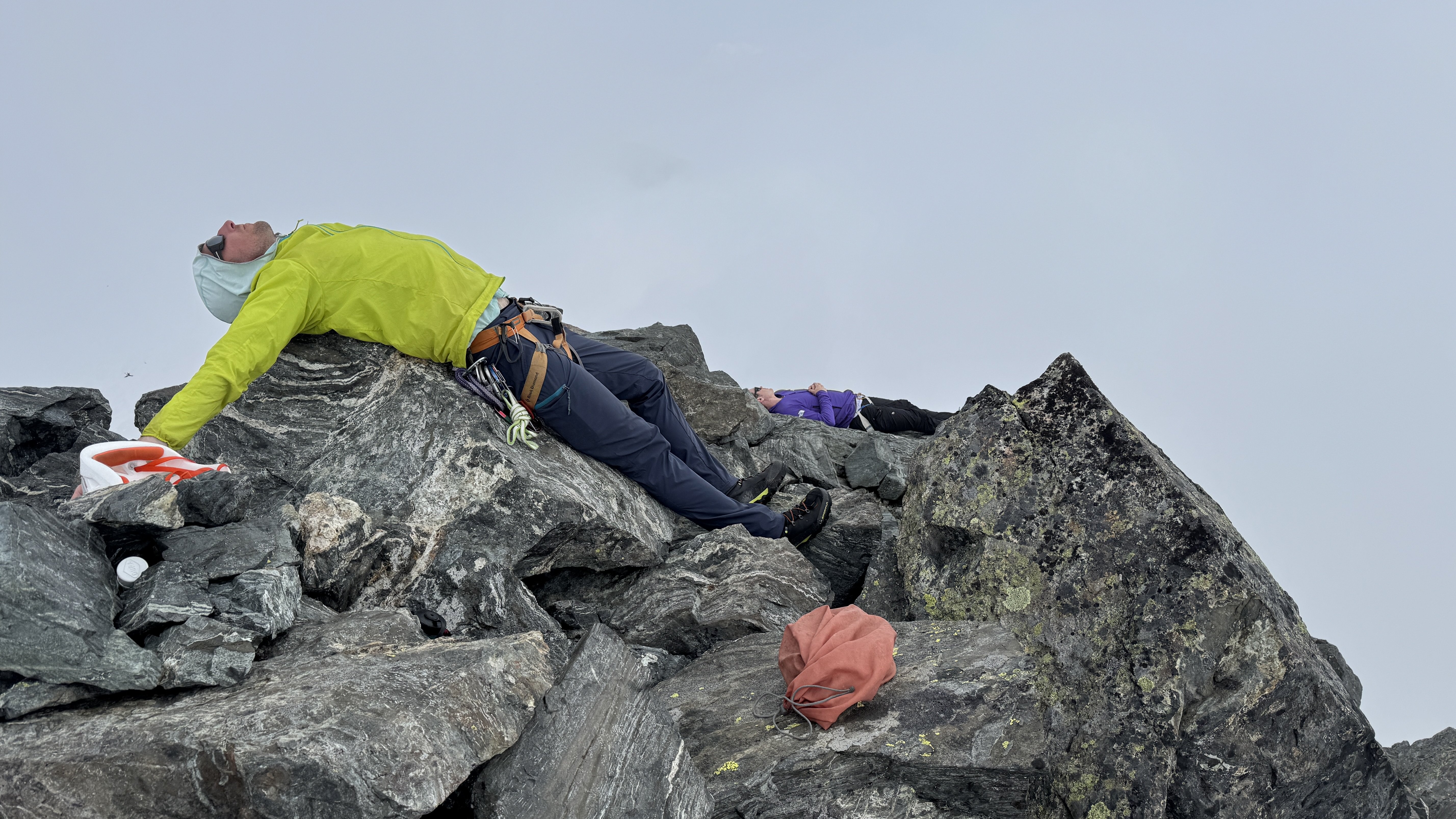
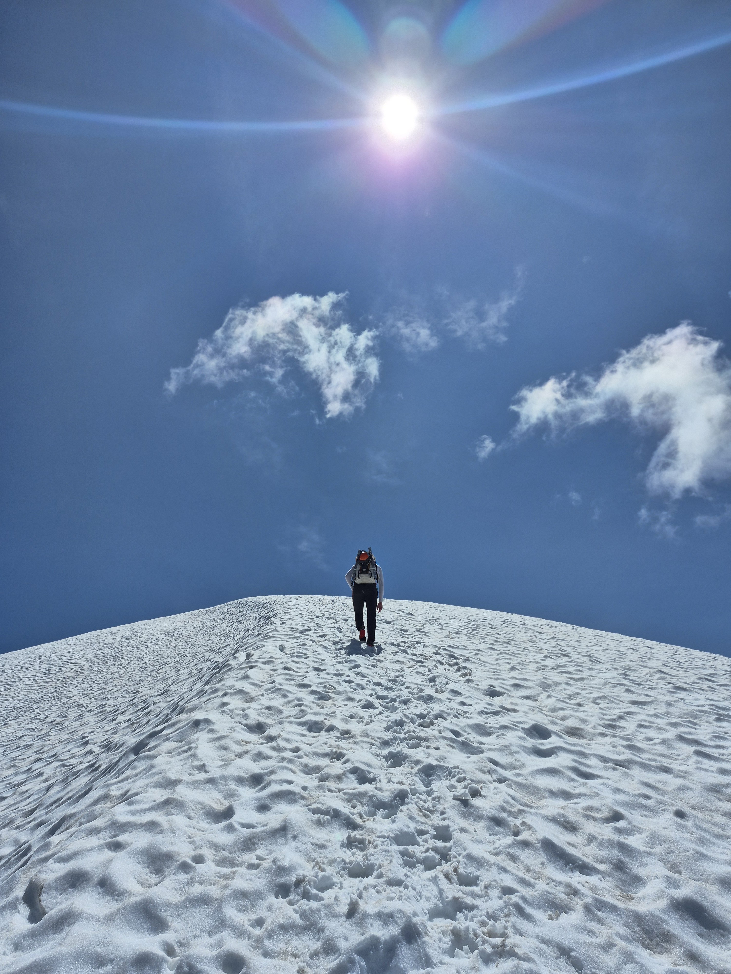
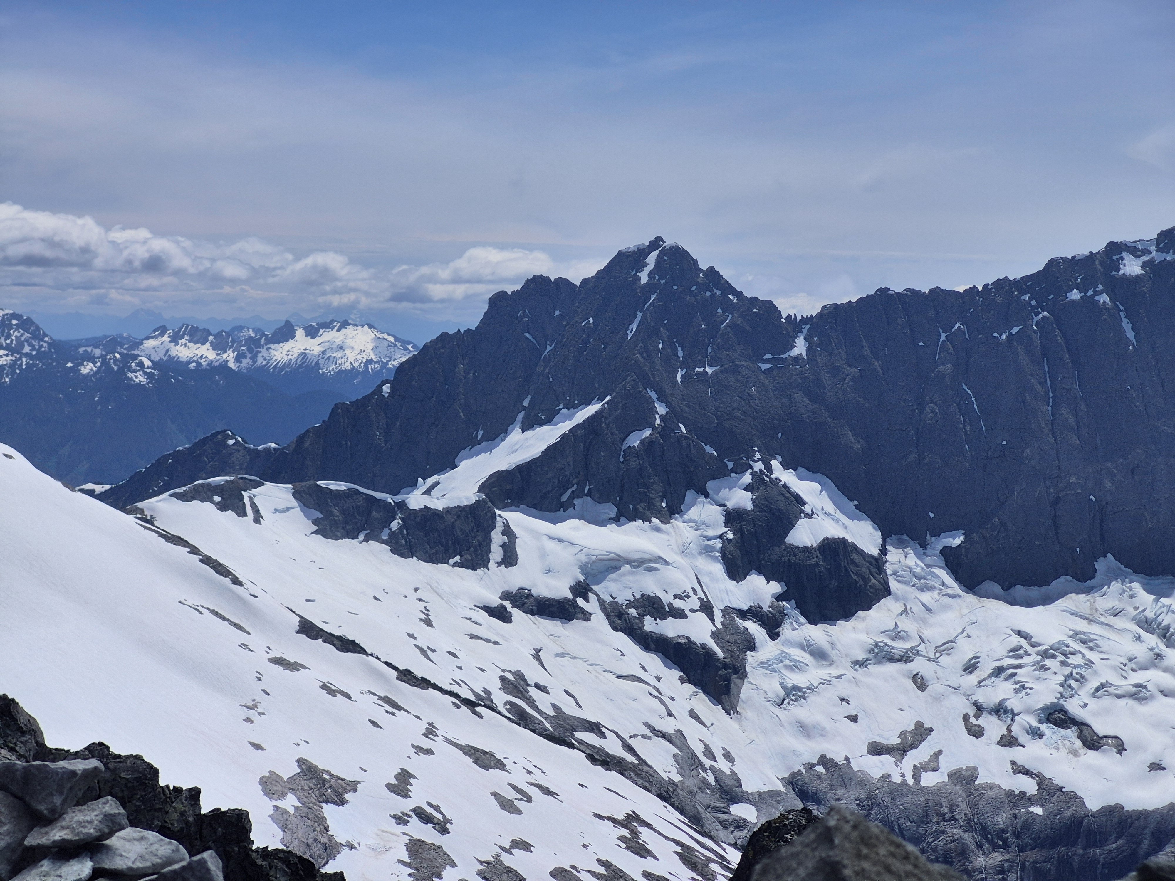
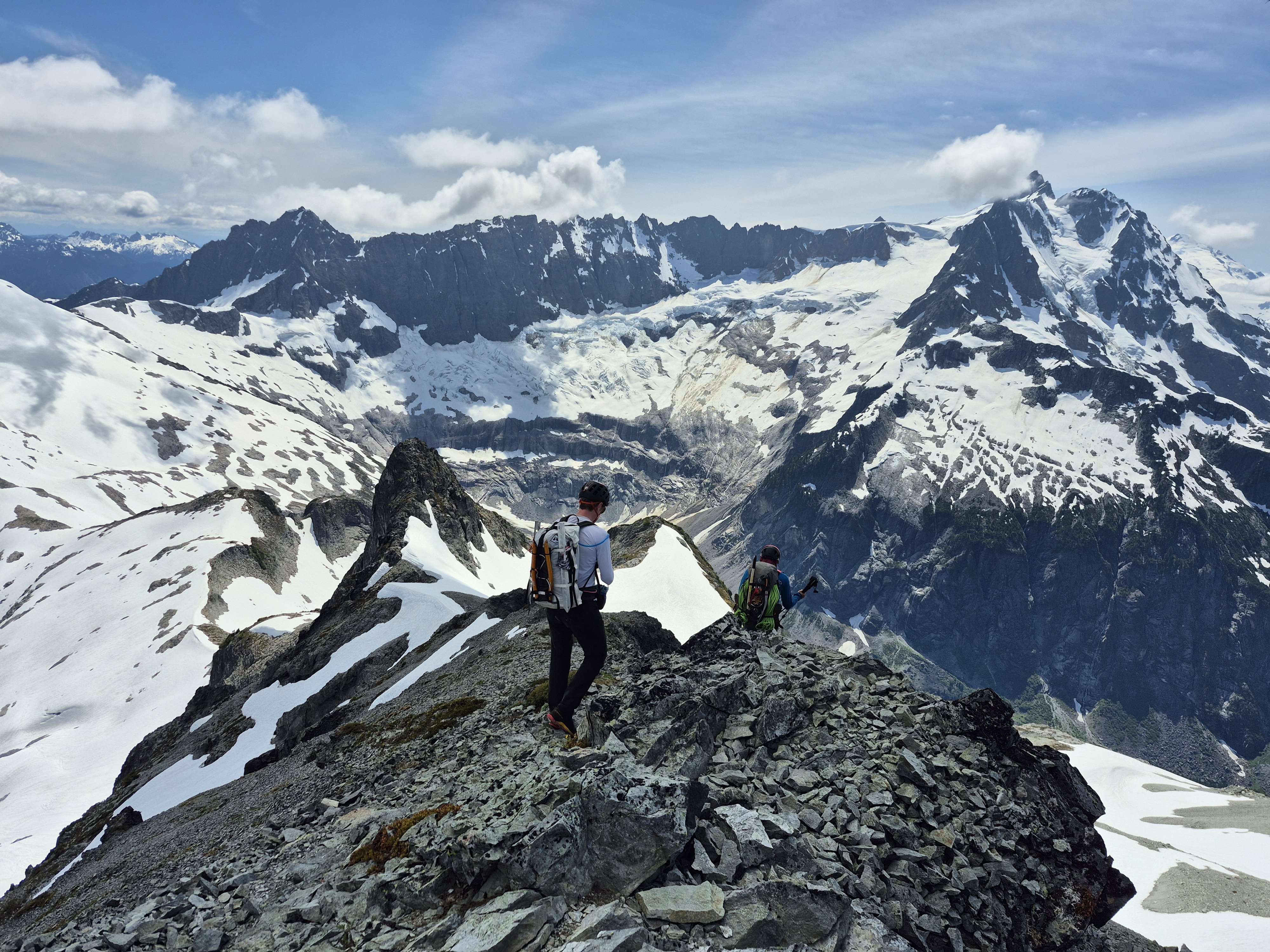
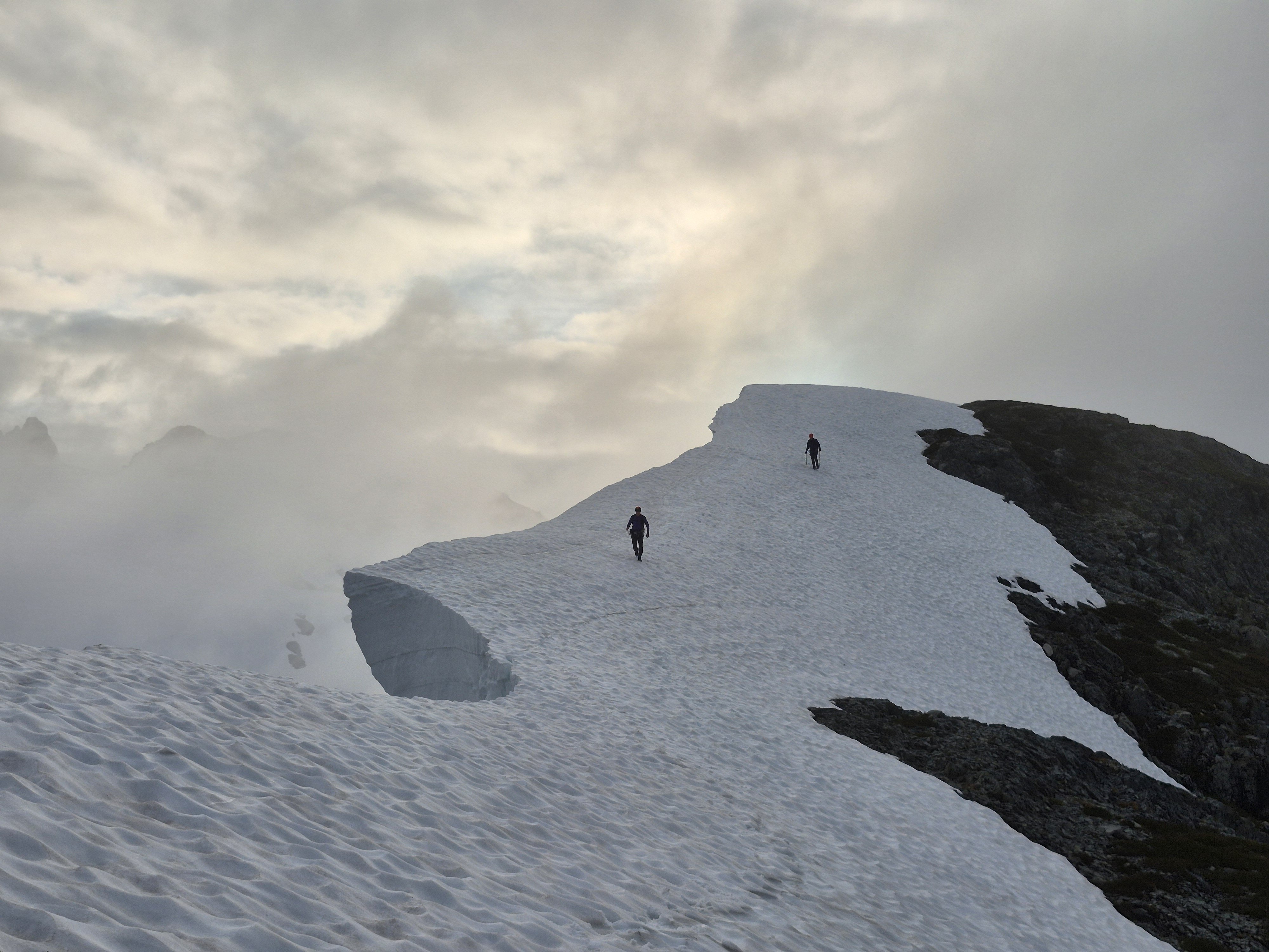
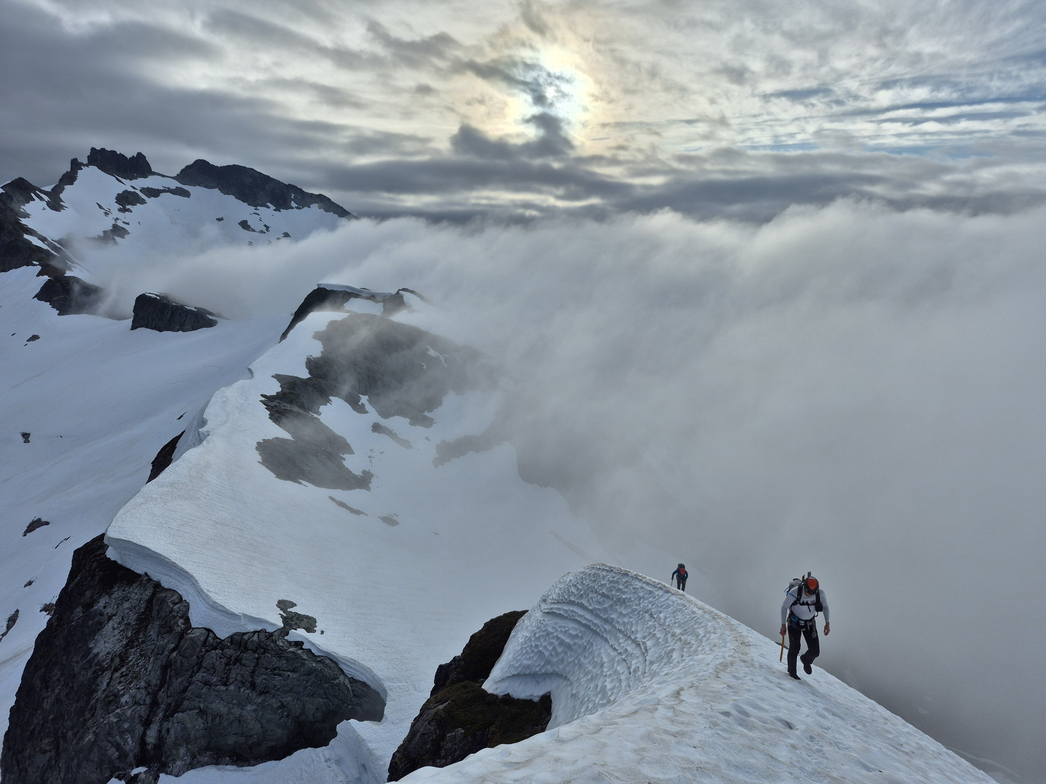
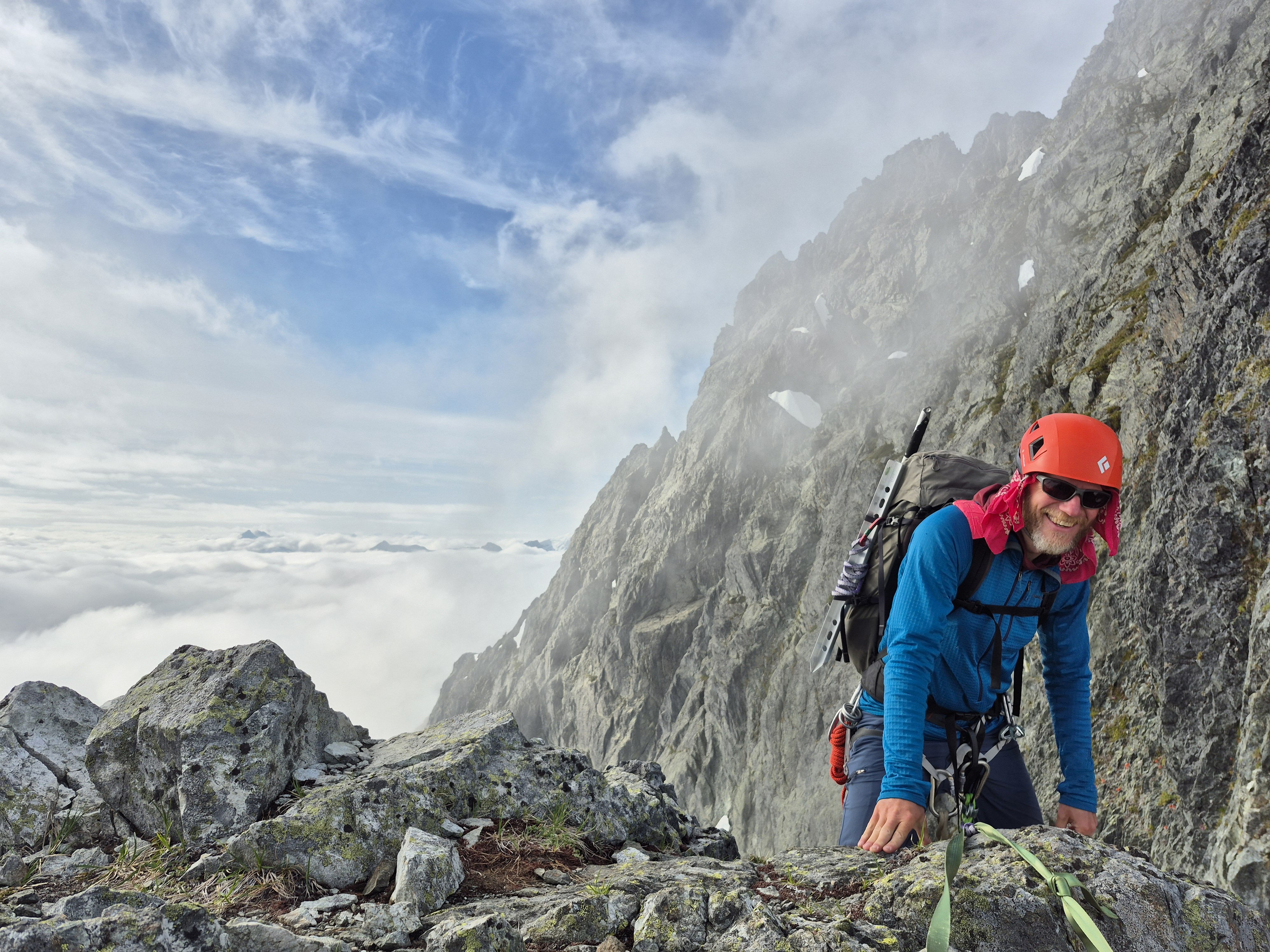
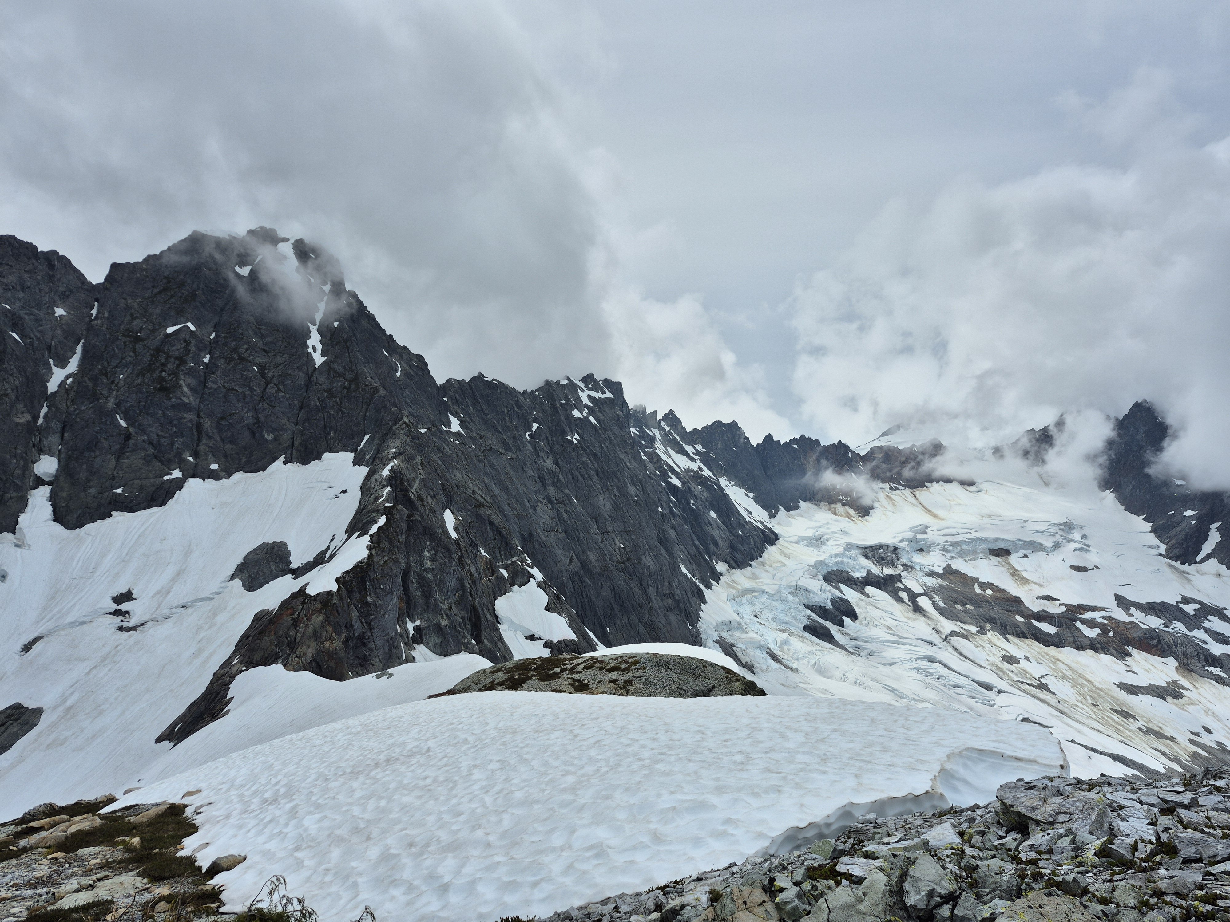
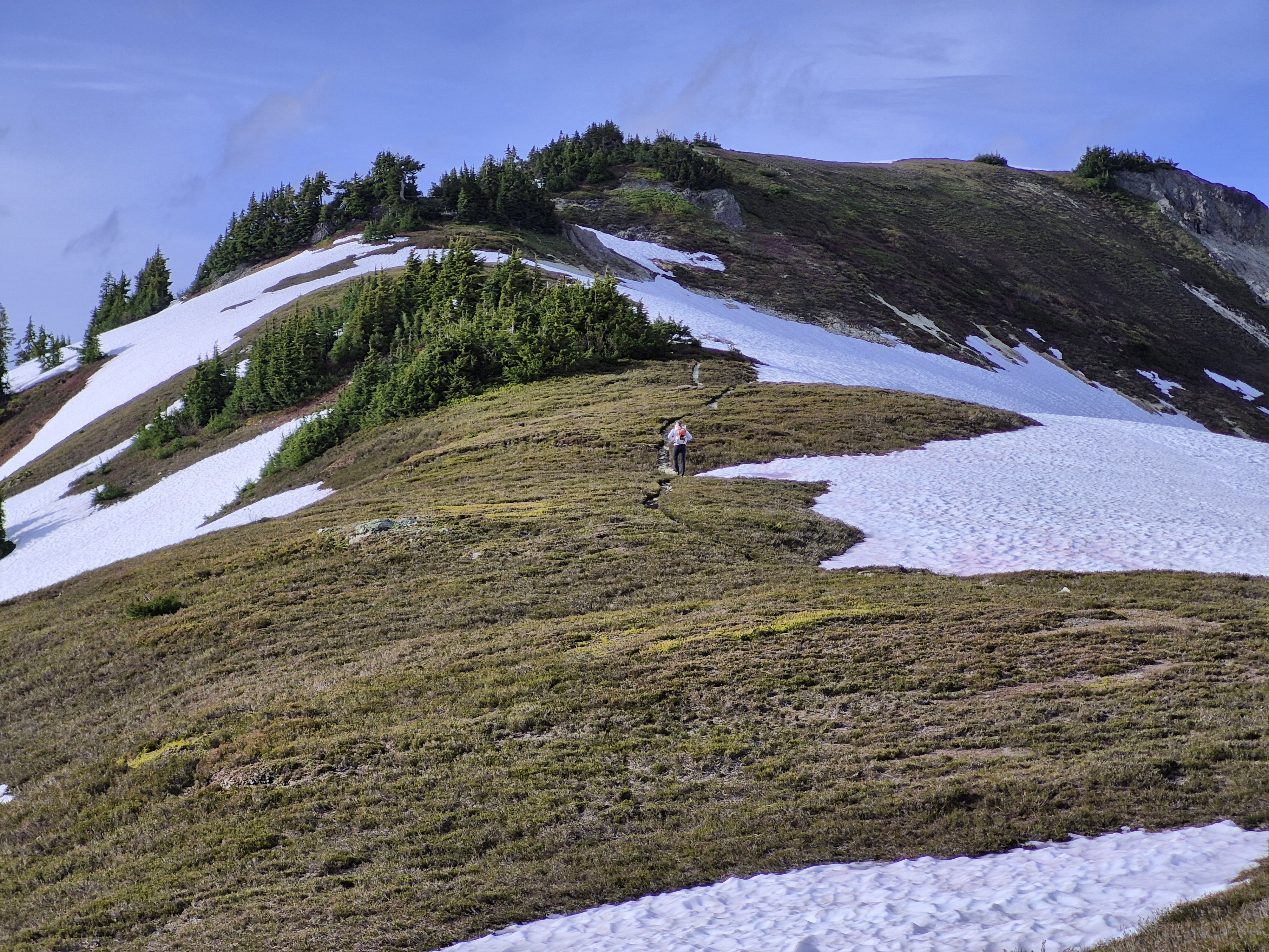
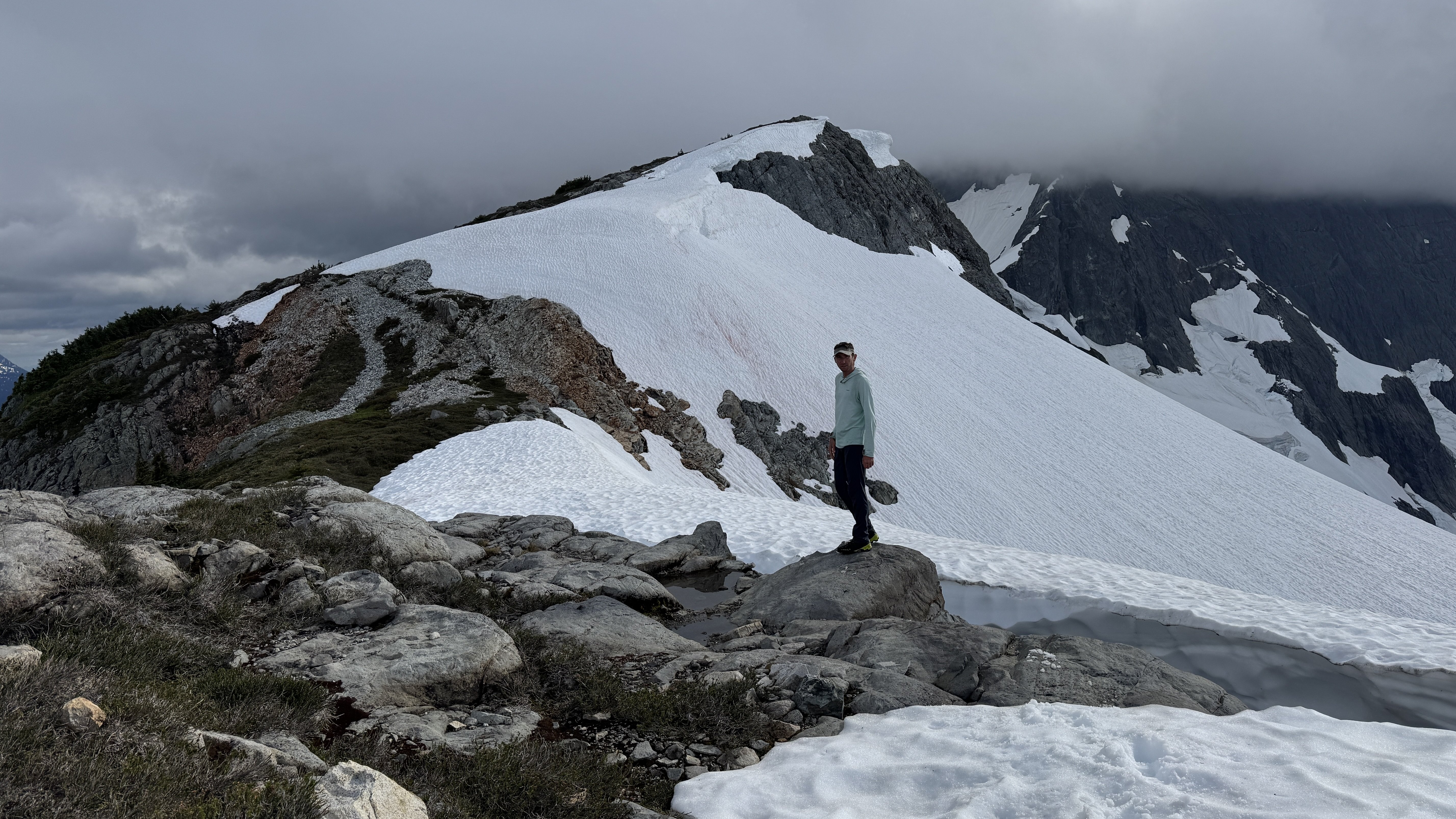
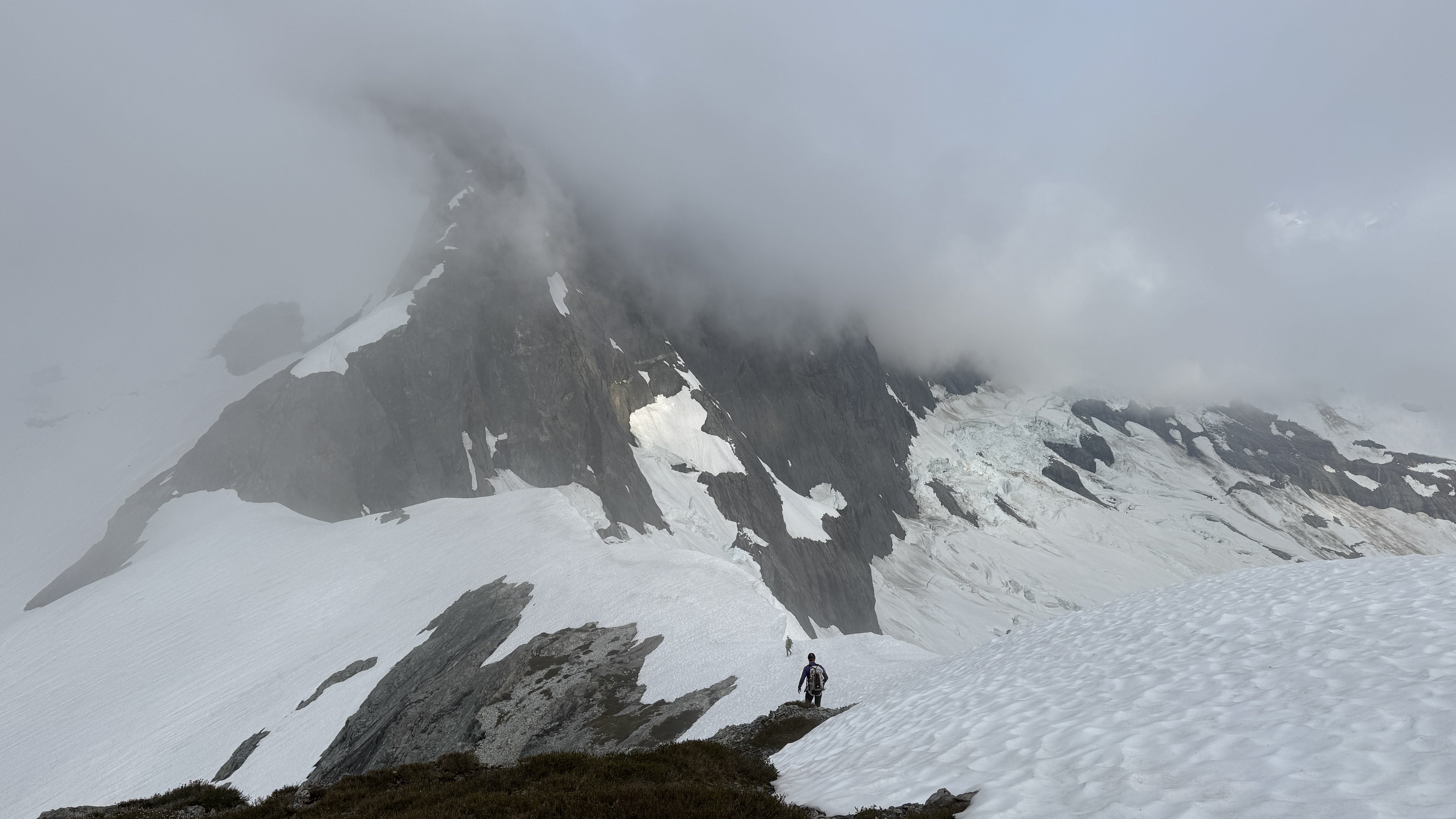
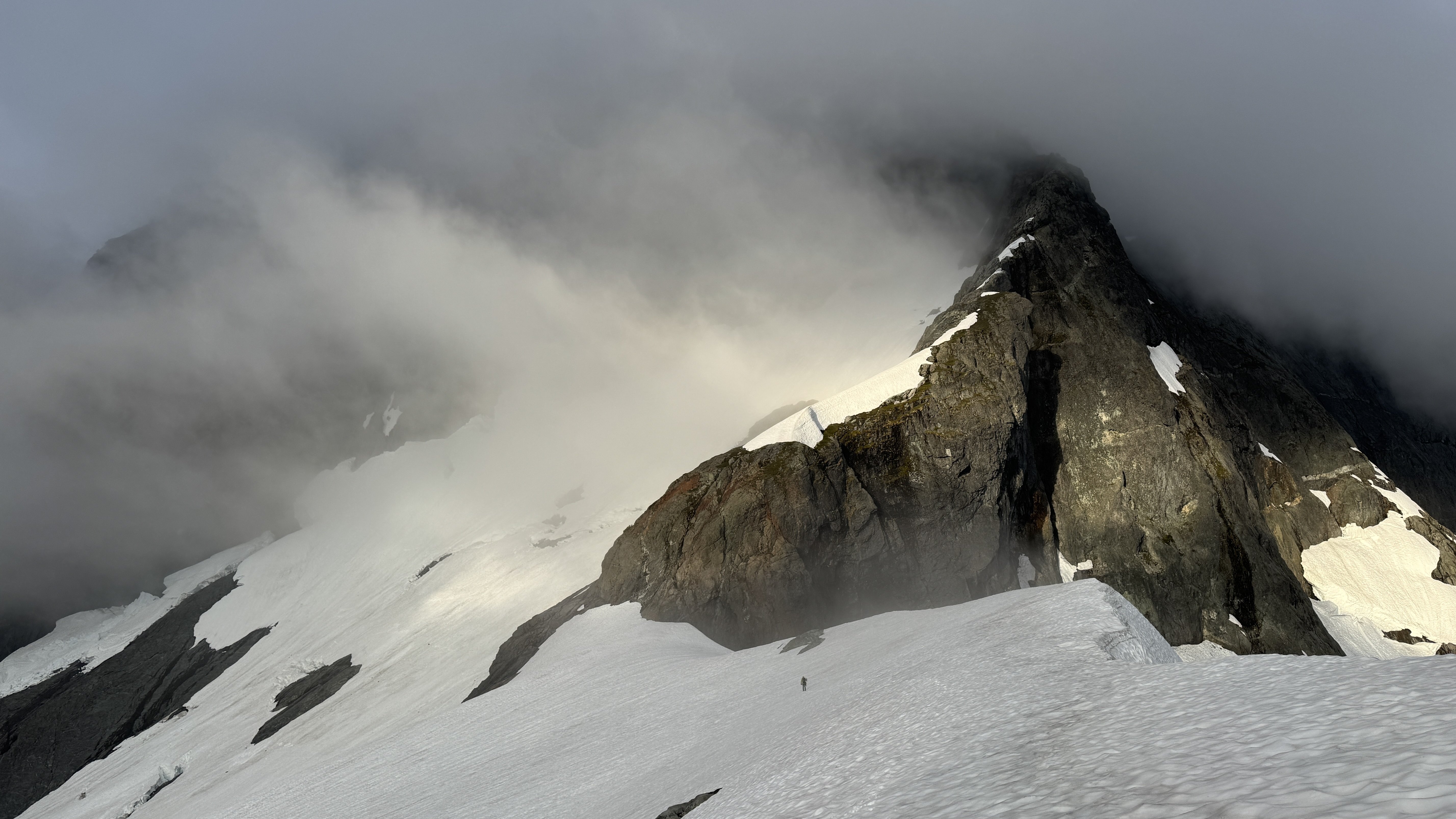
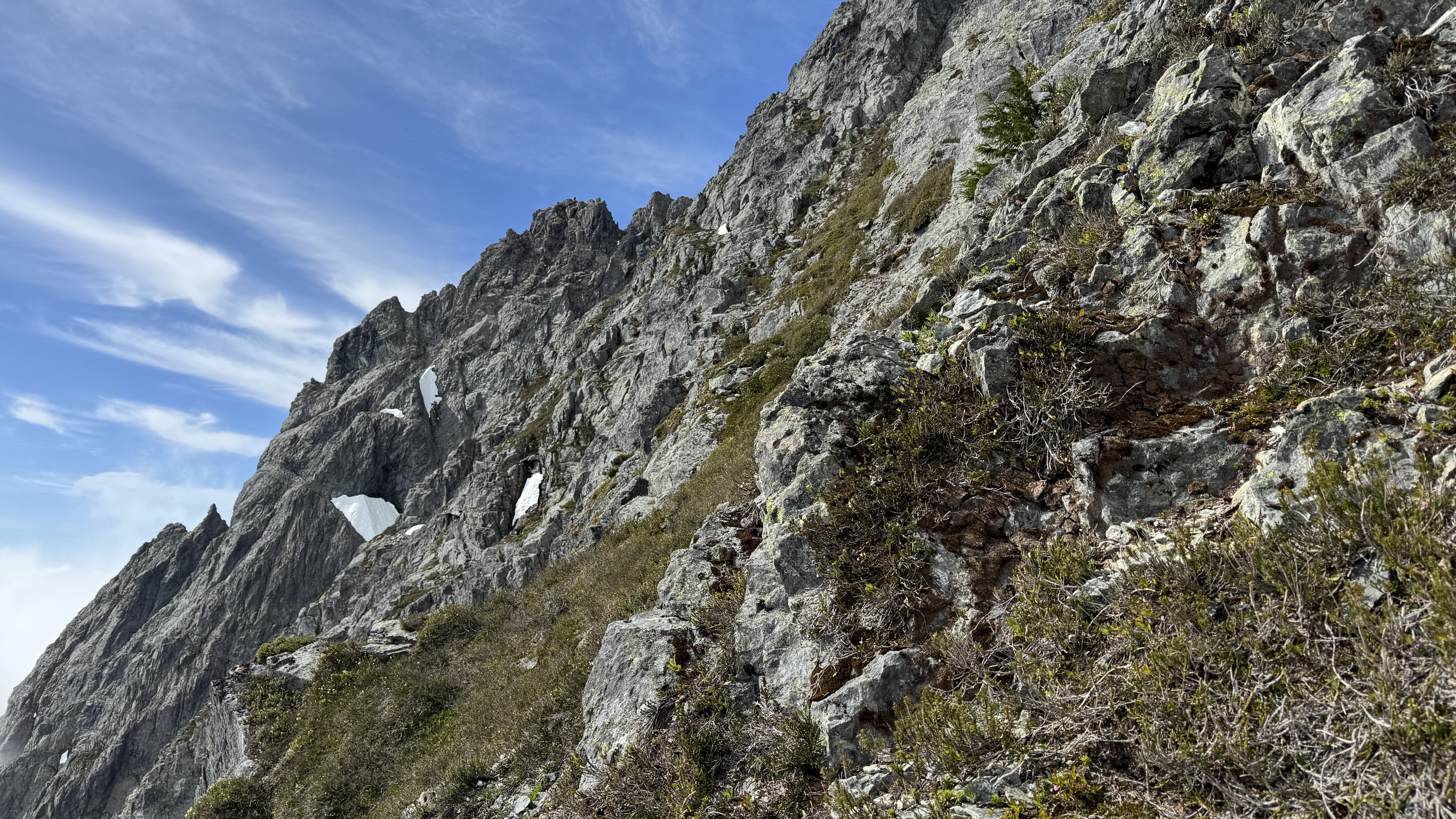
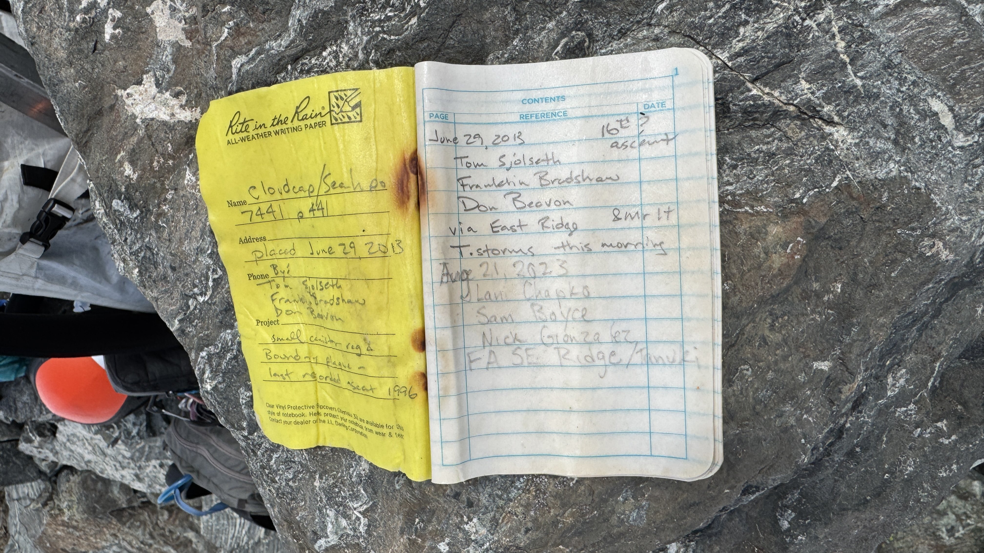
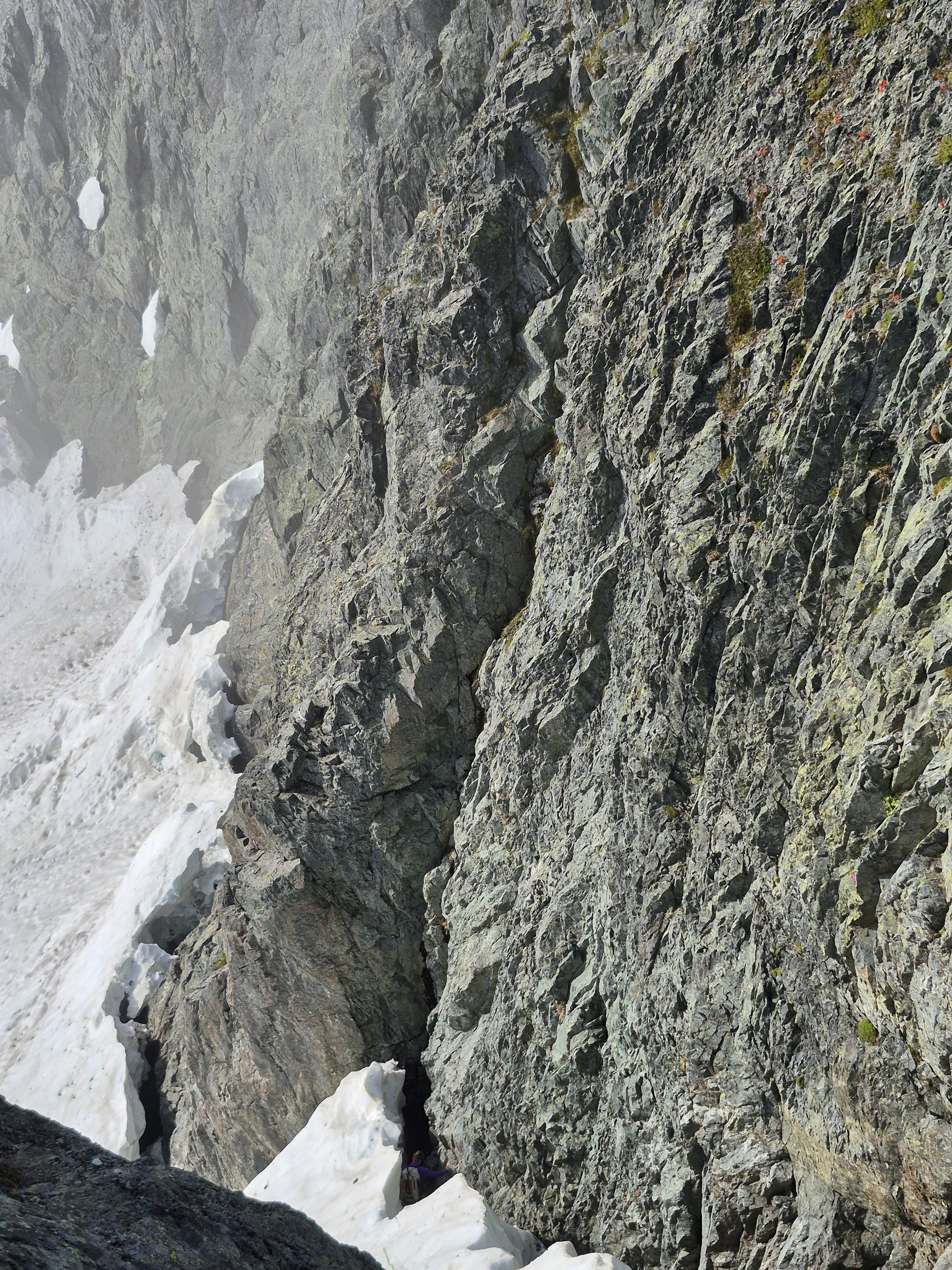
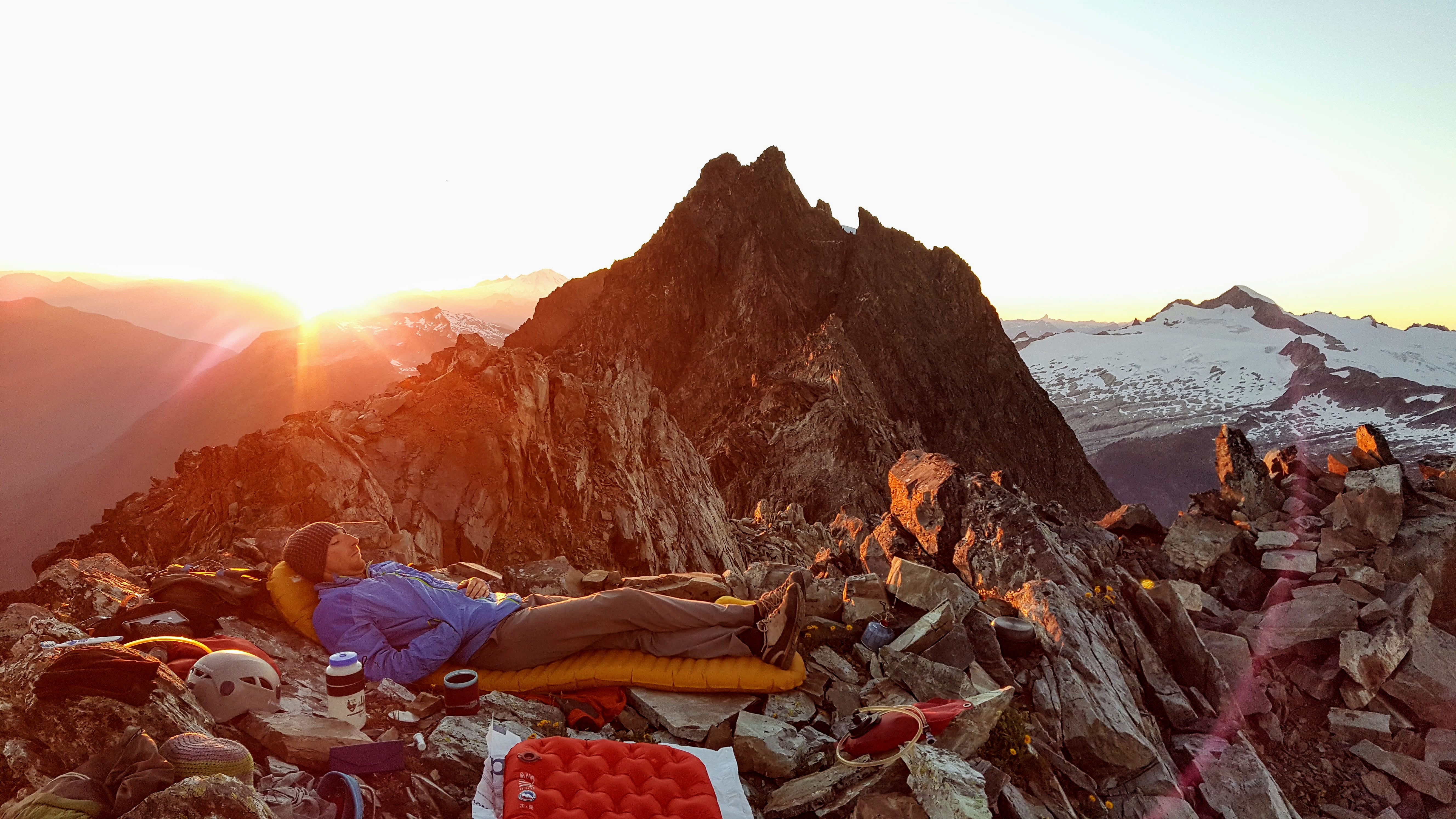
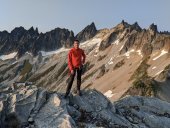
Trip: Seahpo / Cloudcap Peak - NE Ridge Trip Date: 07/05/2025 Trip Report: After much discussion and planning and two planned weekends that didn't happen due to weather, and even a scouting trip with binoculars, me Fred and Dylan finally climbed Seahpo / Cloudcap on July 4th and 5th. I had been on a mission the last few years to climb Dallas Kloke’s Difficult 10 peaks and completed the list this past winter with Lincoln. Now as part of my midlife crisis alpinist proving I'm after the self declared Difficult 10 Bonus Peaks. Basically anything that the consensus says ought to be on the list but since it's Dallas's list it doesn't change (much like the bulgers). I consider these so far to be Gunsight and Seahpo. We hiked up through the crowds on the 4th of July with heavy packs loaded with all kinds of climbing gear since we didn't actually know much about the route. We passed a lot of day hikers and Ruth climbers that all asked us where we were going with all of the gear on our packs, I grew somewhat tired and only half jokingly suggested we tell people either Shuksan or Icy just to make it simple. Bizarrely then we met somebody who replied that they had climbed Seahpo!! We went up and over Ruth, then Icy just for fun and made camp near the northeast ridge of Seahpo, making camp in just about 8 hours. We had plenty of time to study the route as it came in and out of the clouds and were pleased with what we saw. On a scouting trip a month earlier the route had ample snow on the ridge which we weren't prepared to deal with. On the 5th we were up at 5:00 and hiking just after 6:00, thus allowing for plenty of sleep to make up for a week of extremely early mornings for work for me. No one argued with that concept. We took the Beckey variation of getting on the northeast ridge at the first opportunity instead of the glacier which we assumed would be in rough shape this far into the 21st century. The scrambling on the lower ridge was excellent class 3 with some easy snow walking, then we got to the top of a tower before a major notch. This notch was the main unknown of the entire route since there's not really any good way to scout it and we had no beta at all. It proved to be troublesome. Naturally we assumed we would just be able to rappel into the notch and climb out the other side, but it took us about an hour to discuss, scout for a descent, and then eventually build an adequate repel anchor. You repelled into the notch, over a moat, down some easy snow, and into the moat on the far side. The moats were deep but not wide at this time. We huddled in the upper moat a little ways down from (south of) the top of the notch, where we had scouted the only fusible way out of the notch. There was a groove/gully that looked feasible to climb up and regain the ridge beyond. The plan was for Dylan to rope gun the rock in his approach shoes and me or Fred to kick steps in any snow in our boots. Nobody wanted to bring boots, shoes, and rock shoes. Tom Sjolseth mentioned in the comments of his Jagged Ridge TR that the northeast ridge of Seahpo was 5.6 or 5.7, so we figured we needed to be able to do that at least. Dylan was confident that he could lead up the groove, but I stated not so subtly that I wasn't confident I could follow it. He made it look hard but doable, and got a good belay 55m above at a rap station. I'm not sure I have ever climbed on a single rope cow tail style until now, and me and Fred were very very concerned with how little rope we had left, hollering constantly as Dylan finished out to the anchor. (Naturally as in most of the Cascades pro was very sparse and anchor opportunities more so). There was exactly enough rope left for me to stand at the last stance while Fred made it through the most difficult part that the receding glacier had just vacated before I had to step on to the wall and make the hard moves. It was extremely doable on second but I'm glad I didn't have to lead it. Definitely 5.7R. We all made it up to the belay and determined that it looks solo-able above, so we put away all the gear, never to use it again. The rest of the route above was no more than class 4 if you made the right choices, a couple of times just for ease/fun we maybe made it 5.2. Jim Nelson’s book Classic Cascade Climbs must have forgotten about this first pitch, Tom gets a Redding credit in the book so Dylan is convinced that he intentionally sandbagged the route old school alpinist style, not sure, but the first pitch is definitively mid 5th. The book calls the whole route 4th class. We encountered some pretty solid rock on the ridge, easy steep heather on the south side, and a short cruddy gully crossing per Beckey. As I have discovered on most of the more difficult routes Fred Beckey usually pretty reliable. We crossed the gully on a ledge and followed some heather slopes to a short rock finish to the summit. We launch it around for a while hoping the mistwood break and we would get some views but it was not to be. The route finance straightforward enough that it wasn't a big deal in fog but it's always nice to have a good look around. I found out later that we would have been able to holler across to Tim Halder on Nooksack Tower if we could have seen it. The climbing was easy enough that we downclimbed everything to the belay station then made a double 60m rappel to a horn above the moat, south of the initial groove pitch. From here we made another double rope rappel down to the top of continuous snow at the top of the glacier. The upper randkluft it was melted down to where we could land on rock and simply walk out onto the glacier. This rap was long and extremely steep, overhung over sock and then transferring to overhung over snow, pretty wild! I went first and was collecting myself at the bottom of the rap until I thought about the 30+ feet of more than vertical snow directly over my head, so I skedaddled a ways back to the top of the glacier. We all gathered back at the bottom, stowed the ropes and cruised down the glacier, and back along the ridge to camp. The glacier was chill with just a couple of moat cracks to walk around, nothing I would call a proper crevasse, in fact I would hesitate to call it a real glacier anymore; still potentially dangerous though. We took some time packing up camp and congratulating and thanking each other, caught a few last minute views and then headed back up the slog over the shoulder of Icy, back over Ruth, then cruised down the very familiar route to the car. We hit the car about 8:30 for just over a 14 hour day. More congratulations (real this time since we made it back properly), thanks all around, then back to civilization and “reality”. The holiday weekend made it so I could lounge around and nap the next day feeling glad to have pulled off another very challenging mountain. This one definitely ranks in the difficult 10 peaks in Washington in my book, when taken as a whole. I would rate the mountain above the first pitch as pretty enjoyable scruffy fourth class rock and heather, similar to other Cascade peaks; Jberg, Triumph, Klawatti, etc. I think if there wasn't the tough first pitch it would be a pretty enjoyable mountaineering route in a remote location, to me at least, 5.7 ads a level up. The approach was extremely enjoyable and pleasant, better than any of the Difficult 10. We pretty thoroughly scouted the pitch out of the notch both on the way up and down the route and determined that the way we climbed it seems to be the most doable line. If you want to do this mountain you need to be sure you can climb someone insecure 5.7R for half a rope length. If I had to do it again and it was up to me to lead I would take rock shoes. Gear Notes: Half rack, 2x 60m ropes, light MTN boots or approach shoes and wet feet, axe, helmet, others wore crampons, not I, extra axe and pickets for steep snow we didn't need. Approach Notes: Trail to Ruth, over west Icy (the truth summit now thanks to lidar BTW), down the other side. Follow the ridge the whole way. Dylan ascending to heaven on Ruth: The whole deal with my partners looking badass: Seahpo: From camp: Camping in an awesome setting: Morning. Clouds rose up to greet us: Approaching the line: Atmospheric weather: The lower route calls to us: Fred on rap: First pitch from the notch, Dylan for scale: On route: Easy: Break time on the summit: Part of the register. The pencil crumbled in my hands as I signed us in, so take a new one: Fred on the last rap: Descent of the glacier: Strolling out beyond Ruth: