JoJo
-
Posts
73 -
Joined
-
Last visited
Everything posted by JoJo
-
Hi All, JoJo here to tell you about the new "all-in-one" Granite Peak 1:24,000 topo map and complete climbing guide being published by First Ascent Press. It will be printed on waterproof synthetic paper and retail for $19.95. The sheet is 25.2" x 39.2" and folded to 4" x 8". The unique map was created by the award winning Alpine Mapping Guild, the same guys that brought you the Kyrgyzstan map that was with the 2005 AAJ and the Brad Johnson Peru Map. The ink will be dry on the map late August 7th. Ask at your favorite shop and they should have it soon. It is also available right now to purchase online from the first ascent press web site and I'll ship it out ASAP on the 8th. We are also slowly getting the web site up to speed with a forum page where you can go for conditions or to post a trip report. The goal is for this to become the only bookmark you need for Granite Peak. I'm sure anyone researching Granite is tired as I with the random personal stories and 10-year old reports. Thanks for reading and especially thanks to all the cc.com users for all your support of me and First Ascent Press. As a start up single guy business it's sincerely appreciated. We are busy with a similar map and guide for Gannett Peak and some others. The Gannett Peak product will be out this fall - too late for this season but good for planning next summer. It is written by Tom Turiano. Stay posted and thanks again. Cheers, Joe Josephson
-
Hello All, I think the following information is important for anyone trying to use this guide. This is the long version of a book review I wrote that was published in the AAC Newsletter. Good luck. JoJo DRAFT A Climber's Guide to the St. Elias Mountains, Volume 1" by Richard Holmes Reviewed by Joe Josephson Any review I write of Richard Holmes' "A Climber's Guide to the St. Elias Mtns. Volume 1" must start with a disclaimer. I am biased. Veteran of seven expeditions since 1989 I am, admittedly, a St. Elias junkie that finds preverse pleasure in the scrappy rock steps, extreme winter camping, unrelenting ice faces, weirdly crevassed ridges, otherworldly cornices and perpetually nasty weather found there. The important caveat, however, is that "A Climber's Guide" comes out just as I am half way through my own history book focusing on Mount Logan, King Peak and Mount McArthur. As such, I would normally declare a conflict of interest and recuse myself from such a review. However, considering the importance of any book published on the St. Elias Range, I feel it is valid to lend my direct experience to the discussion of this intriguing volume. Holmes' Volume 1 covers 44 peaks, all but one in Canada's Kluane National Park or otherwise along the international border. This includes Canada's highest peak, Logan (5,959 m), St. Elias, Vancouver, Alverstone, Hubbard, Kennedy, King Peak, Augusta, Walsh as well as many of the lesser known giants in the northeast corner of the Park along the Kaskawalsh, Hubbard and Lowell Glaciers. As someone previously unwilling to do the tedious research to piece together the sporadic climbing history on peaks like Mt. Cook, Vancouver, Seattle and Hubbard, I was particularly excited to see what is probably the first such compendium of the established climbs on these obscure, yet world-class peaks not to mention my obvious interest in the Logan group. Picking the book up in Vancouver, BC before a lengthy flight home, I began devouring the book while at the airport. What started as a simple list for my own reference, I began cataloguing any mistakes and confusions on the back of the fold out 9" x 13" map included with the book. Before we even left the tarmak, I had filled up every corner of the page and was scrounging for more paper; exceeding what even the most critical competing author could construe as subjective bias. Victim of so much bad information, I quickly found myself questioning Holmes credibility and ability to objectively gauge a route's potential. None-the-less, this is an ambitious endeavor, creating a systematic description of every major feature, climbed or unclimbed, along with a companion CD containing dozens of color aerial photos, 94 of which are reprinted in B&W in the book. At least one half of the 240+ routes described have never even been attempted, although Holmes' dearth of historical context, leaves an ambiguous "has this been climbed" question mark for more than a few of his descriptions. In fact, it is Holmes confident, in-depth descriptions of routes for which he clearly has no experience that is particularly annoying throughout the book. For example, in describing the yet-unclimbed North Ridge of Mount Foresta, Holmes goes so far as giving exact rope lengths for what is clearly complex and challenging terrain. Even Holmes must have experienced the oft-described "Logan effect," where mountains in the St. Elias always look closer and smaller then they really are. Given this vastness, I wonder how any one can so confidently describe a huge, unclimbed ridge in such detail; especially when flying by at 150 mph in a Cessna. Another example lies on his description of the North Face variation to the West Ridge of King Peak. Here he takes extra time to describe the numerous towers and actual rock quality right down to the "ample holds" on the upper section of the route. Having down-climbed the route as a descent in 1998, I can say his assessment is completely inaccurate and misleading. Further to Holmes' effort to appear authoritative are constant recommendations of when to go and what style to use in your attempt. In recommending Mount Foresta on page 20, he suggests going in "May before the temperature begins to warm up and while the snow is still consolidated." This comes across as nothing more than one of the many rote phrases Holmes pulls out of his literary quiver whenever he needs something that sounds knowledgeable. With changing attitudes and weather patterns, it's been 20 years since May has been considered early season in the St. Elias and it is easily now the most frequented month. In reality, typical "early" season snow in the St. Elias tends to be scary, unconsolidated powder that requires the extra sun and heat of late spring to set up before it starts to destabilize and sluff off all together - quite the opposite of what Holmes leads one to believe. As sandbagging as these suggestions are, the most grievous act is his penchant throughout the book for suggesting fixed rope. Not only are few, if any, parties now fixing rope in the range it is widely considered bad style. Period. As shown on page 183 with the North Ridge of Mount McArthur, Holmes' belief in the importance of fixed rope borders on the absurd. Undeniably one of the easiest (and aesthetic) routes in the book, the only technical difficulty is a 30 meter WI 3+ mixed step at half height where Holmes claims, "It is a good idea to leave a fixed rope to facilitate the descent." Ignoring his earlier mistake of calling this step "about 15 m," I can muster no reason why anyone would find carrying and fixing rope to be easier than a straight forward rappel using the single glacier-travel rope you'll already be using. This is especially silly considering said rock step ends in a completely flat promitory and has a bomber fixed anchor in situ. It would be easier to forgive Holmes this obvioius lack of local knowledge if it weren't for the authoritative writing style. Make no mistake - one or two of Holmes glowing recommendations for the undervalued, future classics are spot on (some things are just too obvious to miss) but overall his authoritative disguise combined with a constant recommendation of using fixed ropes to safely ascend and descend most routes left this reader feeling as I might if caught in a whiteout in the middle of a Seward Glacier crevasse field - a sinking feeling in my stomach and the helpless desire for it all to just go away. Despite his relatively accurate potryal of the higher end mixed routes (easily taken from the literature), Holmes is clearly out of touch with any current trends in Alaskan or Yukon climbing. With suggestions like cotton-blend shirts, wool clothing, a waterproof cagoule, Jumars, minimum 1,000 feet static line, 11 mm climbing ropes, (and what exactly is the difference between "deadmen" and "deadboys?"); his Expedition Equipment list in the Appendix reads like the 1st Edition of "Freedom of the Hills." While describing the easiest lines (if there is such a thing in the St. Elias) up through the attractive moderates and even into the more challenging snow and ice ridges, Holmes seem stuck in 1978. As shown by dated photos of his ascent of Logan's East Ridge (including a faded back cover shot with the classic view looking down on the Hummingbird Ridge) Holmes does have some experience in the range. However his descriptions come across as nothing more than a mountaineer now fallen into arm-chair mode applying a 1970's perspective and style to a current literary review of the journals. Like someone looking through the keyhole and then writing about what's going on in the other room, Holmes takes advantage of the blatant void of information about the range and appears to be making a stand as the authority. This Brad Washburn imitation of aerial photos along with suggestions of the next great routes is not backed up with the climbing credentials, photo quality, nor with a validity of the recommendations that would be required to pull it off; let alone suggest this volume is worth the $29.95 sticker price. The aerials overall are average in quality and almost without exception, wide landscapes that do indeed inspire the imagination towards the many striking features. This renders the CD only marginally useful since the portfolio lacks not only clarity and proper exposures but the all important close up, isolated shots that are required to be of practical use to those looking at new routes. No question, the photo CD is a generous contribution and useful enough; just not quite the product it could be. Perhaps, the misinformation with potential for the most confusion regards the King Trench route. This, the standard route on Mount Logan, is a premier ski-mountaineering objective and is considered the only "popular" route in the entire range. It is here, Holmes' unfamiliarity with the route and negligence as a guidebook author is particularly obvious. Holmes places the King Trench base camp in completely the wrong place and offers a unexplicable reference to starting on the Jefferies Glacier but getting picked up on the Quintino Sella Glacier. When, in fact, one gets picked up at the very same base camp where they get dropped off. Another unfortunate omission is no mention of Gerald Holdsworth's Mount Logan map, published by the Arctic Institue of North America. This is indespensable for anyone headed there. If nothing else, Holmes would have noticed that the Circumski of Logan uses the Mussel Glacier to avoid the dangerous Ogilvie Icefall that he so careful describes in text and illustration. And having been completed perhaps less than a ten times ever, I would have to argue anyone describing the Logan Circumski as "popular." Another critical omission is failure to mention the "Icefields Discovery" camp near Mount Queen Mary. This seasonal outpost, managed by Kluane Lake pilots Andy Williams and his daughter Sian, is a important-to-know-about resource for anyone skiing or climbing on the upper Kaskawalsh and Hubbard Glaciers. Holmes makes numerous comments throughout the book about recommended camp spots that are "well protected from the wind." I've personally been drifted over by seven feet of snow at one of the spots so declared. Thus, I would suggest to anyone using any part of this book that you talk to as many people as you can and do some serious research on your own before blowing your only vacation and hard-earned bucks going after and trusting one of Holmes' recommendations. One of few worthwhile contributions is his comprehensive literature review of the AAJ, CAJ and a few of the popular climbing periodicals. Thankfully, these references are unobtrusive as they are right there with the appropriate description, saving the reader the usual near-sighted exercise of matching reference to route in a lengthy appendix. There are, however, noteable omissions including two ascents of Hub Sew Peak (which Holmes' nicknames "Nice Peak") both covered in the CAJ and Jack Tackle's widely-covered attempt on the long sought-after North Face of Augusta. In addition to the misrepresentations and confusing references on the really big peaks, which in all fairness resist adequate description by any measure, two sections stood out as incongruous. Like opposing bookends, the opening chapter on the Boundary Group seems undeservingly long while the final chapters on the Kaskawalsh and Kluane groups are disrespectfully brief. The Yukon has a long tradition of very capable local mountaineers who have tramped across the Kluane front ranges year round and in every conceivable condition. Any book posing to be a "climber's guide" to the range should either complete the research with verbal and local records and present these worthy objective with the same sense of completeness given the rest of the book or otherwise leave them to the Grizzly Bears and dedicated skiers and climbers of the region. In contrast, the opening chapter on Mounts Seattle, Foresta and Cook span a whopping 34 pages. Granted, these impressive peaks are some of the least known big peaks on the continent but between them, they have a grand total of five ascents. Holmes' generous treatment of the Boundary Group strikes this reader as a covert attempt to drum up business for the nearby Gulf Air pilots that so ably provided air support for his photography. Many of the unclimbed features in the Boundary Group are undeniably compelling and deserving of more action, yet Holmes descriptions here are representative of a tendency to casually disregard and overlook what is often the most dangerous and difficult park of climbing many of the features he recommends - getting to them. A land of big and wild terrain, many routes have long been difficult to access but now with global warming creating visible change throughout the range, many of the features Holmes recommends in the Boundary Group and elsewhere are little more than a crap shoot in terms of finding the right combination of stable conditions, aircraft landing zones, and approaches that avoid objective hazards like seracs, icefalls, and crevasse fields. Herein lies the beta that would be truly useful. Bottom line, there are so many problems with the text ranging from subjective misrepresentations to outright, "this-could-get-you-into-trouble" errors that one only hopes Holmes' chooses to perform his due dilagence, ask around a little more and dig a whole deeper into the research before embarking upon Volume II. Or might I suggest he save himself a lot of writing time, improve his photography skills and simply publish a stand alone photo CD (with a few more approach shots and close ups) with detailed captions and complimented with a full bibliography. Not only would this leave the vision and any preferred styles for climbing in the St. Elias where they belong, with the aspiring climbers, but it would validate a tremendous and important photographic, research effort that is otherwise painfully obscured and un-necessarily devalued.
-
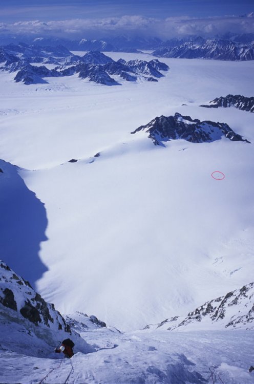
I forgot to mention... That red circle is our base camp tent. This photo was taken a little more than half way up the face. Not quite as high as the shade/light line in the photo of the face above. JoJo
-
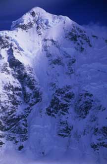
Don, Here's one for perspective. JoJo
-
Don, I tried to post a photo but for some reason it didn't take. I'll try again. Cheers, JoJo
-
Don! Nice to hear more about your climb. During the 6 days waiting to fly out after our route, we brushed off our grade school geometry and figured the actual length of the climbing to be close to 9,000 feet. Hard to say really. Bottom line, it was somewhere between 45 and 50 sixty meter rope lengths of simu-climbing (25 hours spent on the face itself). We called it "Some Kind of Monster." The steepest parts, the bergshrund and one pitch in the exit gully, were 80 degrees/Grade 4ish and the rest was between 60 and 70 degrees. The most amazing thing was the lack of easier snow or neve that we could actually cruise on. There were four sections, no more than 20 meters each where we could actually kick steps into snow. The rest was shiny blue/black ice or otherwise shielded with two inches of detached surface crust that only got in the way. Crazy stuff. My toes hurt for weeks. I was thinking of you several times during the climb. One point was while I was using my ice tool, like in the old days, to twist in a new BD so-called self drive screw. I recalled your stories of the bullet proof ice. The other time I thought of you guys was postholing across the plateau looking for the north ridge. It was storming, and complete white-out, so my motivation to keep going was the spectre of a similar 4 days storm as you had in 91. We didn't have anything but the clothes on our backs, a half dozen Gu each, half a liter of fuel and a small shovel. I doubt we'd have fared well. As such, once off the summit cone (which included a 200 foot overhanging rappel over a serac) it took four hours of thigh-deep wallowing but we found it which would not have been possible had I not been there in 2003 when I climbed a variation to the North Ridge to the East Peak. For what ever it is worth; we had both Grivel and BD screws and in the future I will take only Grivel screws on a climb like this. The BD screws were by far harder and slower to place. The Grivel screws, despite taking up more room on the rack, were far superior. We had 17 screws total when we started. We dropped two. Also, the seracs on the face are not so bad - as far as seracs go. The approach and the gully near the bottom are the most exposed places (from the upper cliffs off the edge of the plateau). The ones on either side of the exit gully look more dangerous than they are. They showed no signs of recent calving. On June 6 there was some mild seismic event and for 24 hours or so tons of shit fell off in weird places but nothing moved down the North Face Route we did. The most common hazard was spindrift. If there is any snowflakes in the air and a whiff of wind, it heads down that face. The collection zone is massive. We finished the exit gully, some of the best climbing I've done in the St. Elias, in a complete spindrift avalanche. It was quite desperate really. It's a bummer we couldn't enjoy the climbing more. To top it off, the summit pyramid was blue ice right to the top. As a result we angled off to the east to some lower angle snow about a pitch from the top but baled due to the storm. It would have been nice to stand on the summit of my favorite mountain. Although shorter than my route on King Peak and not as technically cruxy (King Peak has a WI 6 pitch at 15,000 feet), "Some Kind of Monster" was by far a harder route overall. King Peak had 4,000 feet of snow and neve at the bottom and was not as consistenly steep. For comparison, it took Steve and I "only" 13 hours to climb the SW face of King with 3 belayed pitches and 10 simu-climbed. There would be no way I'd climb more than a few hundred feet of McArthur's North Face without being attached to the face some how. The ice was just too scratchy. It was the most draining and probabaly the hardest route I've done. Fortunately it was also one of the rare climbs where all our efforts come together well. No dropped pots (like what happened on Catenary a week before), no forgotten gear, making the right decisions at the right time. After about a half dozen of these single push rigs, this was perhaps the first time it all came together perfectly like it should. Any how, I gotta get back to work. Cheers, JoJo

-
FYI: The routes in Newfoundland (I've been there twice) are up to a few hundred meters with a few over 500 m. The biggest cliff face on the entire Rock is only 800 m. "Slipstream" in the Rockies is right around 1,000m with 1/3 being snow. "California Ice" is close to 1,100 m if you do it all early season when the gully is all ice. In other words, there are lots of 1,000m +/- water ice routes all over the world. But, like I said, these don't compare to the glacial, pure ice alpine routes. The West Face of Cerro Torre is around 1,000 m of actual ice climbing from the col. I'm sure the big rigs in Asia are much bigger but they also have significant stretches of snow, shortening what might be considered the pure ice climbing parts. The Great Coulior on Robson is over 3,000 m, but it could hardly be called an "ice climb." It's a specious definition at best but the reason I wonder is that we did a route in the Yukon this spring that was unique to my experience. It was blue/black ice from top to bottom except for four or five sections, no more than 20 m each, where you could actually put your feet into snow or neve. Although not hard at any one spot, I've never seen an alpine route quite like it and all the tent time waiting to fly out got me thinking if there are many others like it. So, I figure if there is anyone that keeps track of these sort of things, it would be the readers on cc.com...
-
Hi All, I'm doing some informal research on the longest ice climb(s) in North America or the world. This doesn't include big snowy walls like the Wickersham or even the Cassin Ridge that have a considerable amount of snow slogging but rather pure ice climbs. I'm talking primarily alpine ice since most, if any, water ice routes can compare to some of the Alaskan and Yukon ice beasts. Michael Down told me there are some monster ice routes in the Caucasus but I'm not familiar with the area. Does anyone have any beta or ideas on what peaks might have the longest ice climbs? Cheers, Jojo
-
Hello, I am working away on a book about Canada's Mount Logan, King Peak, & Mount McArthur. A history of climbs, guidebook, coffee-table sort of thing. I plan on having the book out in late 2006. I am trying to contact climbers from all the first ascents or early and important repeats. Among others, I am looking for contact information on the following climbers. Any help would be greatly appreciated. Please send any one's personal information to be via PM only. Thanks in advance. Joe Josephson MOUNT LOGAN Is any one from the King Trench's 1950 3rd ascent still alive? Gordon Herried Alston Paige Mark Christensen Schoening Ridge 1952 Gibson Reynolds Dick McGowan Bill Niendorff 4th Ascent of King Trench 1959 William D. Hackett William E. Blanchard Dr. Norton Benner David V. Bohn Jules M. Eichorn Richard N. Kauffman Clarence E. Le Bell 3rd Ascent East Ridge 1961 - a Boyd Everett Jr. Expedition Albert Nickerson Jr Leif Patterson Edward Carman Walter Gove Independence Ridge 1964 Gregg Blomberg Edward Amstutz William Basset Eliot Coleman Frank Magary Richard Springgate Robert Baker David Stelling Thomas Stewart HubSew Ridge 1967 Will Harrison A. Bittenbinder D. Shaw Ed Ward Catenary Ridge 1967 Davd Ingolis Donald Schmenchel Steve Connary North Ridge 1974 Kurt Schuttenberg Bruce Balderston Al Mathews Hummingbird Attempt 1978 Jim Logan Barry Sparks Ralph Randall Trover West Ridge 1978 Jonathan Waterman Steve Davis Roger Hirt George Sievewright Catenary Variation 1979 Frank Sarnquist Al Bergland Steve Ericson Early Bird Attempt 1985 Dan Batwinas Mick Deiro Tim Laughlin Jeff Jackson KING PEAK First Ascent King Peak 1952 Alston Paige Keith Hart Elton Thayer Bill Atwood East Ridge of King Peak 1952 - A Schoening Expedition. Vic Josendal Bob Yeasting Dave Harrah Verl Rogers Tom Morris Gibson Reynolds Dick McGowan Bill Niendorff West Ridge King Peak 1966 - an Everett Expedition. Dennis Eberl James Birney Joe Davidson Art Davidson Pete Hall Thomas Hall Emile Nava Edward Nester MOUNT McARTHUR North Ridge Attempt 1953 Richard McGowan Tim Kelly Tom Miller Dick Long North Ridge Attempt 1961 William Dougall Richard Wahlstrom Lute Jerstad Steve Johnson Ronald Priebe Gary Rose North Ridge First Ascent 1961 George Wallerstein Sy Ossofsky Alexander McDermott South Face New Route 1993 Greg Collum Mark Landreville Paul Gonzales
-
Check www.montanaice.com for up to date conditions and there is also a partners page. Hyalite has been going off! Several new melt-freeze routes last week. Although it did snow recently so the avy hazard is a concern on some routes. Most routes in Hyalite are in great shape. It has been cold all week so it's only getting better and should be good for another month. You can still drive to both parking lots. Once in a lifetime conditions for March. It ain't the Rockies but damn fun with a hundredth of the people...
-
A few comments: Although a few parties under the radar have probably gotten on it over the years, there have been no serious attempts at the Logan/Stump route on Robson. Many a party has gone wanting - only to never leave Berg Lake. There has been at least one serious winter attempt at a new route to the left. Infinite Patience is well-right and no where near the Logan/Stump line. The FWA of Alberta was via the Japanese Route. The NF has only 7 ascents total and hasn't been seriously attempted since the late 90s. Never mind the global warming effects on the lower icefields, the one at the top has turned into a serac. Cheers!
-
Greeting Ice Fiends, A BIG thanks to everyone who has supported "Winter Dance" and my new company First Ascent Press. There are updates and corrections to the book posted on the forum site below. There are also a few reviews of the book as well. Nothing like the best ice year in 10 to coorespond to the book's publication. The same thing happened in the Canadian Rockies in 94/95. Maybe I should come out and do a guide for the Cascades See you in Ouray and at the Cody Roundup in February. Cheers, JoJo http://www.firstascentpress.com/forums/index.php
-
I almost forgot... Same Show - Different Day... Bozeman - Friday, November 12th in the Weaver Room, Emerson Cultural Center $5 at the door. All proceeds go to the Southwest Montana Climbers Coalition www.montanaclimbers.org For info call: Barrel (406) 582-1335 or Northern Lights (406) 586-2225 Thanks!
-
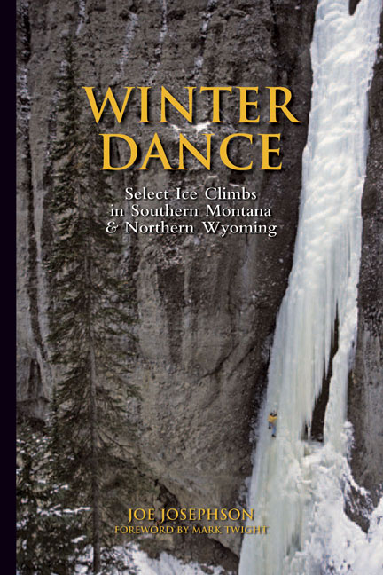
"If it's not too late... Make it a cheeseburger." Or in this case a slide show - Wednesday, November 10th, 7:00 pm. @ Feathered Friends at 119 Yale Avenue North, Seattle. (206) 292-2210. $5 covers admission and a beverage. Come see photos, stories and hear JoJo's perspective on the development of ice climbing from the ground breaking explorations in the early 1970s through the latest thoughts on "modern" mixed climbing. Using routes and images from his latest guidebook, "Winter Dance."
-
See attached TOC 407207-TOC_Winter Dance pg 1.pdf
-
Good news and bad news. Bad news: I have tedonitis from unloading boxes. Good news: I will be shipping "Winter Dance" to stores tomorrow (Tuesday the 26th). Onward...
-
Canada, Shmanada... Seriously, there is ice NOW on the Sphinx, all over the Beartooths, even a few things starting to come in Hyalite and Cody (give it a week or two). Almost every alpine ice route in the Tetons is formed and have been getting climbed for over a month already. Go big or go home. JoJo
-
The new guide is called, "Winter Dance: Select Ice Climbs in Southern Montana & Northern Wyoming" will be available next week (firstascentpress.com). It features 100 Cody routes with almost 10,000 vertical meters of ice climbing in the South Fork. Our government, in their infinite wisdom, seems to think the new guide is a threat to national security and ordered it to sit in port for an extra week. It is now scheduled to arrive on the 26th and thus should will be available in stores by the end of the week. There will be an article about the history of ice climbing in the South Fork in the December 1 issue of "Gripped" magazine. There have been a number of other articles written about Cody over the years with a cool photo essay appearing in Rock & Ice a few years ago. And from 1994 to about 2000 there was a significant contingent of traveling ice climbers from Canada, Montana and Utah that would "Gather" there. The February Ice Roundup (southforkice.com) is now attracting a few hundred climbers. The main reason its not in the spotlight is that be that it's pretty far from anywhere populated. Also, the rock in the area is best described as kitty litter and there is little mixed climbing. With the media winds blowing towards the latest and hardest M routes, Cody gets overlooked. It is truly the land of hard water ice. Despite what many people think, the magazines only print what they are given. Epic approaches, capped by long routes, some of the best ice pitches in the world and not getting eaten by a grizzly are the experiences found there. Unlike Colorado and Canada, not too many people are tromping around the South Fork thinking about how they can get into the latest "Hot Flashes." Go there. It's awesome. The climbing has already started in a few limited areas (Carter Mountain). It has been perfect weather patterns thus far and is looking to be a banner year. If temps stay mild there will be good routes to do by mid-November and most years you can climb there until mid April. Of course, "freakish" warm spells can hit anywhere at anytime and that's just bad luck. The biggest problem many climbers have had over the years in the South Fork is most things are invisible from the road. I've driven down that valley many times thinking nothing is there but, in any year there will be over 150 pitches to do. In a good year close to 300. By describing the area in detail for the first time, the whole goal Todd Cozzens and I had with including Cody in the new guide was to give climbers more success in finding pitches. And I respectfully disagree about finding more miles in Ouray. Go to the top of Mean Green or Smooth Emerald Milkshake and you'll do more feet of ice than three average days in Box Canyon. I will admit though, there are no real beginner or top-rope areas like Ouray, Genesis in Hyalite Canyon, or the Canmore Junkyards. If you can climb well in the South Fork, you can climb well anywhere. Pray for an arctic front, JoJo
-
Thanks to everyone interested in the new guide. Here are two quick updates. The book will be available October 25th and it's a finalist at the Banff Mountain Book Festival. Onward into the fog, Joe Josephson
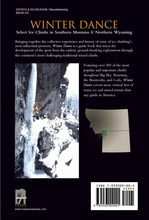
-
Greetings anxious ice fiends, The mountains around Bozeman and the Beartooths recently received their third significant snow storm of the fall. It could be a good ice season ahead. Still about a month away from climbable ice but it's looking better than it has in years. We need some more melt-freeze for a few alpine things and a cold snap for the main ice climbs. Cross yer fingers. I thought many folks might be interested in a new guide book available November 8, 2004. Any feedback or support is appreciated. "Winter Dance. Select Ice Climbs in Southern Montana & Northern Wyoming" by Joe Josephson. It includes 300 routes in 320 pages with 380 photos. 6" x 9" - full color throughout. The book is dedicated to Alex Lowe with a Foreword by Mark Twight. Areas covered are: Madison Range (Sphinx & Big Sky), Hyalite Canyon, Pine Creek, the Beartooths, South Fork of the Shoshone River (Cody) and Cooke City. Perhaps the most anticipated aspect of the book is that the Cody area finally has detailed route and approach information in addition to several condition report web sites. Hyalite now has detail on many more options as well. Thanks for the time and pray for an arctic front. Cheers, JoJo