


lizard_brain
-
Posts
1471 -
Joined
-
Last visited
Content Type
Profiles
Forums
Events
Posts posted by lizard_brain
-
-
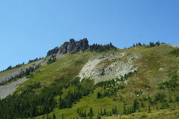
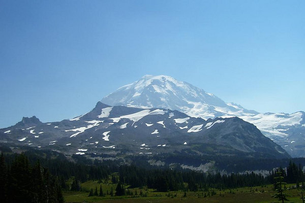
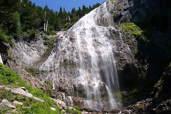
Spray Park. 6 mi. RT., 1300' gain. Plus you have the option of scrambling Hessong Rock for more views, if you feel up to it. Make sure to catch Spray Falls on the way back - go beyond the end of the little spur trail - just a few hundred more yards up and beyond the end of the trail - for the REAL falls. Nice place.
Hessong Rock from Spray Park:
Rainier from Hessong Rock:
Spray Falls:
-
Okay, I want one!
-
ZZZZZZ-zzzzzz-ZZZZZZZ-zzzzz-ZZZZZZZZZ......
Another dead-end, boring thread.
-
Shoot things.
-
Uh-huh...
-
Fuck this shit. I'd rather go climbing.
-
From CNN:
"In 2005, the U.S. Department of Transportation's National Bridge Inventory database concluded the bridge was "structurally deficient."
(The whole article is here.)
Tom Everett of the Federal Highway Administration's National Bridge Inspection Program said the structurally deficient rating was a "programatic classification rather than an indication of safety."
"It does not indicate a bridge is dangerous or that that bridge must be replaced,"
Okaaaaaayyyy... This bridge isn't unsafe, it's just 'structurally deficient'. Say that just before it collapses.
-
From CNN:
"In 2005, the U.S. Department of Transportation's National Bridge Inventory database concluded the bridge was "structurally deficient."
(The whole article is here.)
-
-
There's video of it
-
Love the pics. We were a day behind you guys. Great rock up there.
-
It's about halfway up the summit pyramid - I'll get a better description from my partner. It was right near the top of a ridge before the route drops one last time before it traverses easily then goes straight up the last pitch or two. I think he scrambled up that ridge a few extra feet to take a couple of pictures, and left it there.
-
Actually, someone else invited me to do that climb again next month. I might take tham up on that and snoop around for it while I'm up there...
-
As good an excuse as any. Girth hitch it for pro!
-
Would one of you who was recently up there mind marking this elusive "non-slab" descent to save us some time?
 I'm going next weekend but have only been up there in the snow.
Also, how is the creek for crossing on our way to Long's Pass?
Thanks!
I would just say cross over the ridge to the Cascadian just below the false summit, stay off the snow, and as you head down, stay to the right of the big black pillar. The route in the lower couloir is crappier than usual, probably due to washouts. Creek crossing is not an issue.
-
Stay to the right of the snow (skier's right).
-
Nope.
-
My partner lost his camera on the upper part of the West Ridge of Stuart on Sunday. Black neoprene case.
Anyone?
-
citations please
It's on teh interweb.
-
Who uses hotmail?
-
Would add to this thread, but am having chest pains - must go...
-
Starbucks = McCoffee
(I do drink it on occasion, though.)
-
Summer Job
in Spray
I lived in Walla Walla during high school, and during one summer I worked nights driving pea combines. I worked 12-hour shifts, 6pm to 6am. Just drove back and forth 3-4 miles an hour all night. Sun went down, stars came out, sun came up. Brought a few joints and maps of the constellations to keep occupied.
-
Silly!

Scenic hikes in MRNP
in Mount Rainier NP
Posted