


dberdinka
-
Posts
2272 -
Joined
-
Last visited
-
Days Won
27
Content Type
Profiles
Forums
Events
Posts posted by dberdinka
-
-
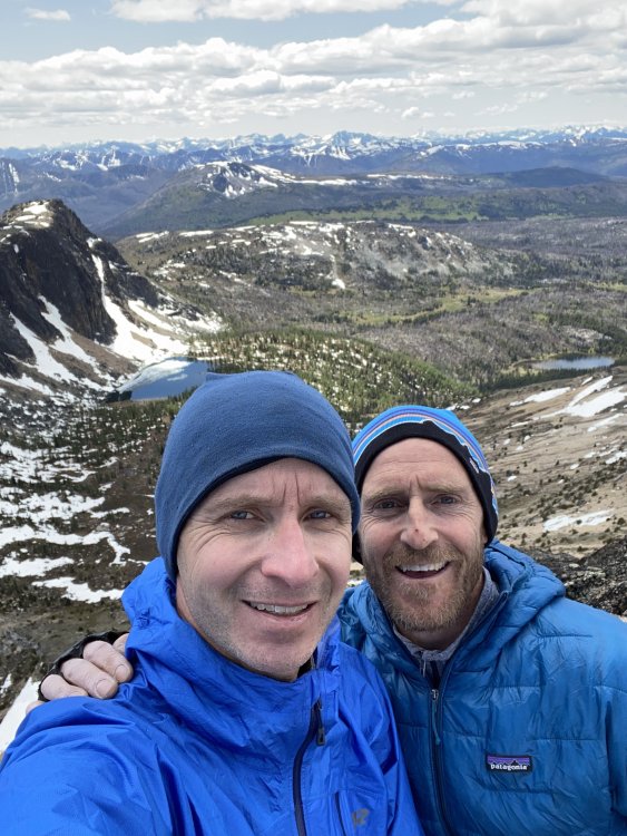
Sixteen years later we went back. Sixteen years is a long time. A lot has changed and a lot hasn't. That southeast buttress is still as good as ever.
-
 1
1
-
 1
1
-
-
Trip: Twin Sisters - Obscurities Redux
Trip Date: 08/23/2020
Trip Report:
It's been a long time since I posted a trip report and even longer since I've gone explorer-ating in the Twin Sisters Range. Twelve, twelve! years ago Dave and I pushed, pedaled and slogged our way into the basin between the Twin Sisters to climb some nice rock on the obscure Block Tower.
The block is split clean through by a hand size crack, and while we had climbed the very short east face, the west side was much larger and steeper. I always wanted to go back but the approach-to-climbing ratio is pretty excessive and that logging road is just a soul sucking grind, particularly loaded down with a full rack. But in twelve years the world changes and e-bikes, well if not invented, at least became far more ubiquitous and I reached the point in life where one ended up in my garage. Plenty nice around town but it fundamentally transforms the experience of these long logging road approaches. The dreaded grind now feels like a casual ride to Sunday Farmers Market. Once you ditch the bike your legs are still fresh. Climbing the North Twin has become a casual afternoon jaunt. Highly recommended!
So with a different friend we rolled in less than 45 minutes. The path into the basin seems far more beat in than it was ten years ago and people were scattered around in ways I had never seen. Really it's rather insane how busy everywhere has gotten, but I digress.
As for the climb. The west face of Block and Arrowhead Towers are somewhere between 350'-400' tall and the rock quality is generally very good. We climbed two pitches (red) of low 5th-class ramps leading up and right to the much steeper upper half of the route. The first pitch was marred by a very chossy and unavoidable 3rd class gully. A far better start would be up clean north-facing slabs to the right of the tower (blue) to where you could scramble back left to below the headwall.
.thumb.jpg.97f3009f6ae05877b6eb3a3d880f7540.jpg)
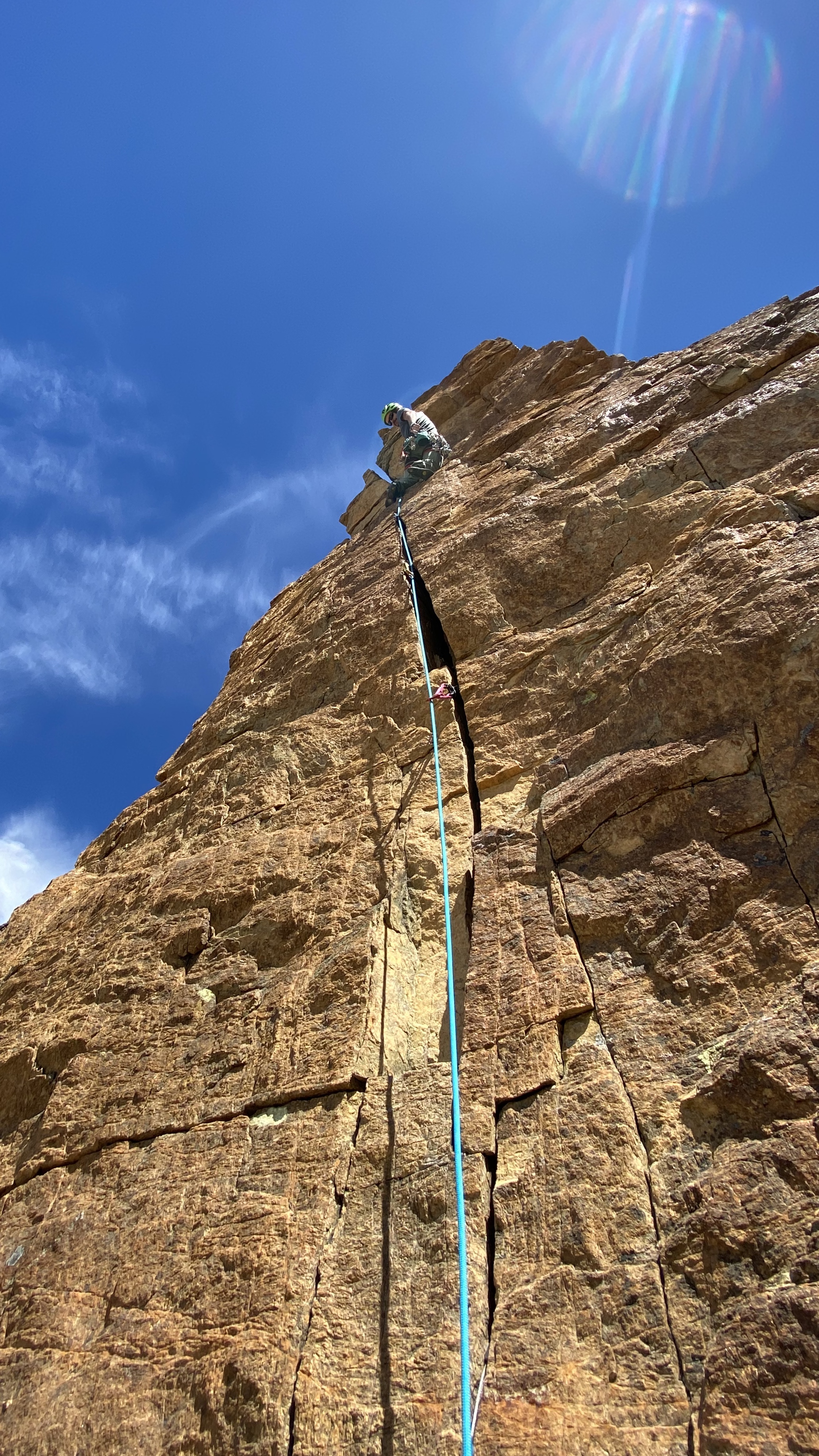
The head wall was probably slightly less than 200' tall. You could do it in a single pitch but there's a perfect belay ledge at the base of the final splitter if you want to share the goods with your partner. The third pitch started out easy and a bit brittle. Fortunately rock quality improved as the angle increased. I stayed left of a very large detached block and climbed slightly overhung jugs with intermittent gear into the left of two parallel crack systems. It was heady but adequately protected. The final pitch is probably 40' in length but has absolute hero jamming through overhanging bulges. Both were maybe 5.9? Good stuff.
A short rappel (make sure to TR the rap line) and a steep but easy scramble led down onto the glacier. From the col a series of 3 well-established raps led back down to the base of the climb. A nice climb, I'd go back. Other potential still abounds.
Pitch 2

Pitch 4


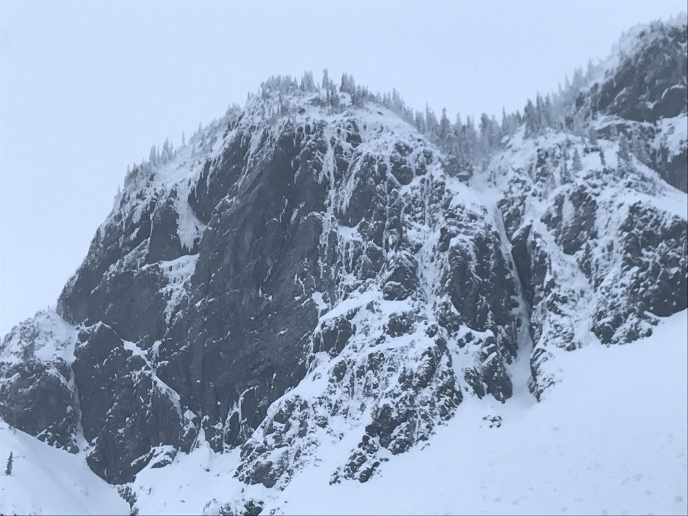
From the Basin - Arrowhead Left & Block Tower Right

Gear Notes:
Doubles of small cams, single set #1=#4 maybe an extra #2
Approach Notes:
E-bikes-
2
-
 6
6
-
-
Lots of good rock in that valley but too far and too filthy to be worth the effort. Still plenty of potential up on Mamie Peak.
-
1
-
-
Bug net. <$10. You’re a tough guy right!?
-
In that they never enforced TH parking this not an actual change but if it makes you feel less guilty about getting out I guess that's good.
-
2
-
-
2004/2005 was a shit winter like this and access and climbing conditions in the mountains were sweet! Pray for the Pineapple Express! (those of you who still engage in such shenanigans).
-
2
-
-
^
x
x
x
x
xx
x
x
x
x
x
xx
x
x
x
x
x
xx
x
x
x
x
x
x
x
x
xx
x
x
x
x
x
__________________________________________
-
2
-
 1
1
-
 1
1
-
1
-
-
The crossover descent has always sucked compared to just bombing down the south side to your pre-stashed bike. Not a popular opinion though.
-
I'm not sure I would have done what I did if I had realized how popular those routes would become. The trail is noticeably being pounded into dust and I've become old enough to feel an intrinsic need to kick over the preponderance of unnecessary cairns. How many hundreds of pounds of fecal matter are now hiding under rocks in that gorgeous basin? Whatever you do don't drink the water without (heavily) treating it. Of course Vesper seems to have blown up with hikers/instagram crowd about the same time, so maybe that area would have been hammered rock climbs or not.
Jason, I just spent Friday night at Image Lake with my family. No one else until early evening when a very chatty party of two showed up. Saw only a handful of folks heading that direction over the weekend as we hiked out the Suiattle. Talking to the volunteer manning the Miners Ridge lookout, in the 1960's over 200 people would be at Image Lake on summer weekends. He said that in the early 1970's over 1,200 people were recorded at Capa Lava/Sand Point on a a single day. So crowds and heavy use are nothing new. Maybe just the location du jour changes or it all just ebbs or flows. Ultimately it falls back on managing the individual impact which clearly a lot of current backcountry recreationists are falling short on.
BTW kmfoerster what did you think of Fish & Whistle? I really liked it, thought it was the best route up there, but apparently some have not been so impressed.
-
IMO the whole lack of a top pocket sucks. I bought an HMG 3400 Porter and just can get use to the crinkly fabric, bottomless tube and lack of top pocket. If you're a hard ore alpinist or whatever, great, get the stripped down newest greatest thing. But since you're "a backpacker the majority of your life" I would stick to Osprey.
-
dick cilley......when I was 17 years old in the ancient year of 1990...you were living out of your van selling gear in Icicle Creek...no one around....plenty of camping......those were the best of days......
-
So looks like no log for a river crossing? I don’t feel like I’ve ever seen it in wadeable condition.
The couple people I know who have done the central arete raved about it, but with multiple options the choss had to be somewhere. The left arete was a little too easy, I still need to get back in there for the central.
-
Well with the weather crapping out through at least Friday with significant precipitation it's going to be a bit more than 3 days.
-
I didn’t realize those were in the Cascades. Stay on topic dammit!
-
1
-
-
So with the north face of Joffre spontaneously collapsing, Supertopo shutting down and CC.com slowly withering on the vine my mood shifts to considering the impermanence of everything. What other peaks and routes have seen their last ascent in our lifetimes? Gene Pires and I once made the possibly second and possibly last ascent of the IV 5.10+ east-north buttress of Castle Peak in the Pasayten wilderness. A year or two ago someone posted pics where at least the first 5 pitches of the route had collapsed.
Off the top of my head
Anything on St Helens 1980
East face of main Gunsight. A III 5.9 established in the early 1990s that had disappeared without a trace (except for a fixed stopper just below the summit) by the time interest in the area renewed.
East-north buttress of Castle Peak. A good but flaky route on clean granite that fell off during the winter of 2016/2017.
Trigger Finger in Peshastin Pinnacles. Someone on this site had a good story about recreating a clown-car on the summit shortly, as in day of or before, it collapsed.
An impressive looking pillar on the east side of Mt Rexford just over the Canadian Border, with an unrepeated V on it, had a major rockfall event that erased the route.
What else peeps?
-
Backside of hemispheres. Have I seen it fatter? Not sure. Definitely seen it thinner and the ice somehow looked not quite so sn-icy as usual. By modern standards it certainly looks doable.
-
2
-
-
This is very cool. Where is the TR Mr. OlympicMtnBoy.
-
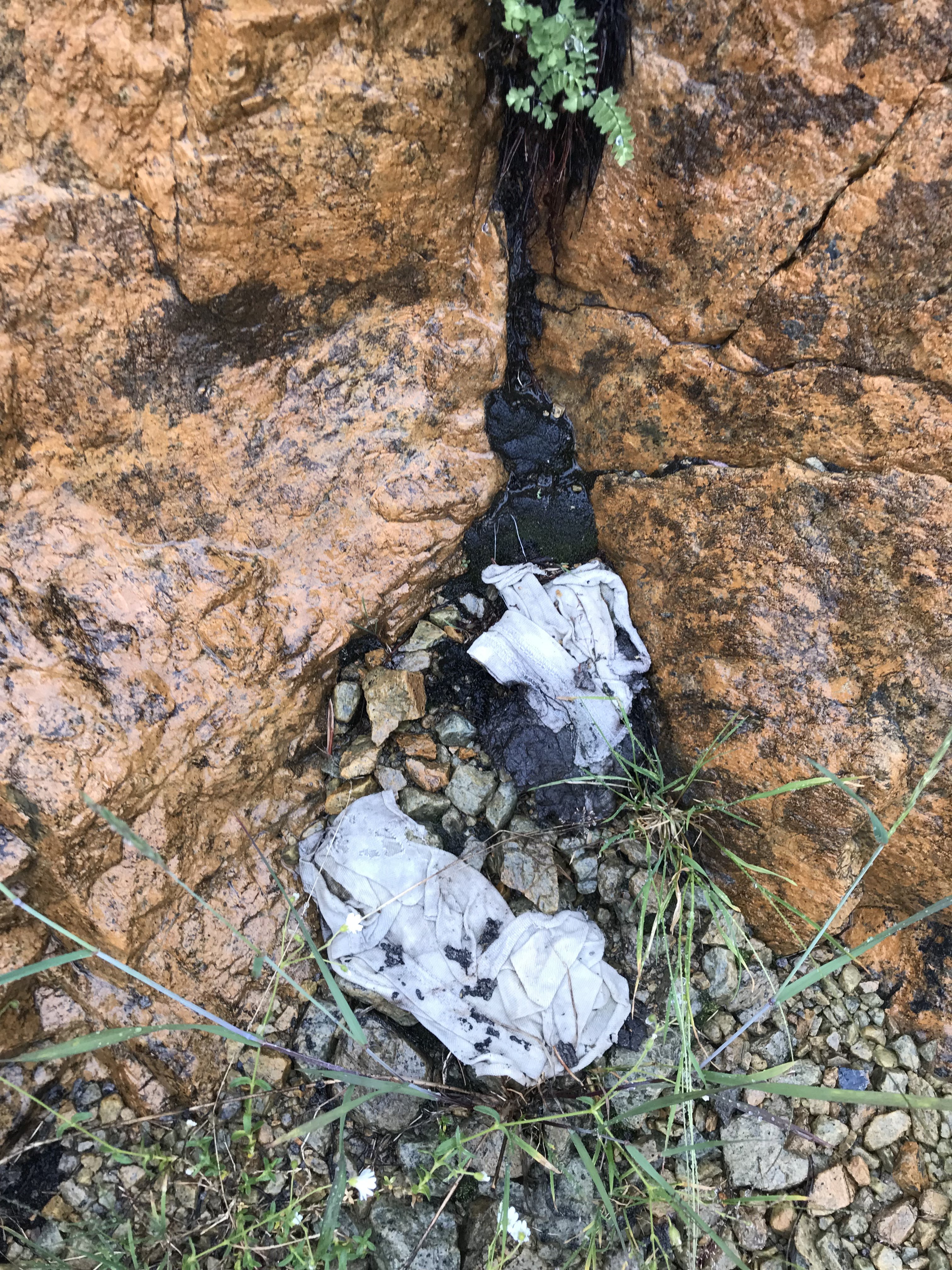
But.... The idea that she was taking a selfie and fell off the standard north face route seems entirely plausible. No way that red thing is still there by spring. Too bad, hard to believe no one checked it out. Could be clothing, back pack something else that got hung up.
-
Dude!!! Have you been doused in ketamine for the last six month?
I wish I had never gone anywhere near Vesper Peak and helped in my own little way into turning that corner of the Cadcades into a total shit show.
-
1
-
-
So.....that’s a great fucking trip report......Jesus.....tell us more about the car! Insurance going to cover it? A now permanent fixture? Or are you in the hook to get it removed?
glad you made it home safely, that gully approach is NOT daddy terrain.
-
1
-
-
As it gets more popular I hope people work to keep it as pristine as they found it. Unfortunately in that sterile an environment it seems pretty easy to leave a lasting mess behind, witness the desicration I nearly stepped in on the “grassy benches” last weekend. Dig a hole! WTF!

-
 2
2
-
-
I like you're TR a lot but before others follow you down the gully of doom I recall it being fairly straightforward to follow your "second option". Climb some broken rock to near Marble Needle where a couple short rappels put you on the Mccallister Glacier near the standard route on Dorado Needle.
-
Maybe your epic was a result of all that photo taking. Great pics, looks like an awesome climb, wish I could remember it.
-
Nice looking mountain you got there.

.jpg.90be698e956cab4b2a7dace76c279f8b.jpg)


[TR] Slesse, BC, Canada - NE Buttress - *Descent update* 08/07/2020
in British Columbia/Canada
Posted
Fred Beckey, on at least his first attempt, approached Slesse from south of the border. Probably Twin Lakes down into Silesia Creek. That would a fine and historic adventure to recreate in this summer(s) of Covid. Be careful, the border patrol seems to be flying the border on a daily basis though hard to believe anyone would be trying to get in.