


Lowell_Skoog
-
Posts
2524 -
Joined
-
Last visited
Content Type
Profiles
Forums
Events
Posts posted by Lowell_Skoog
-
-
Was it Chuck Welsh that you met?
If so, did you know that he was in the first party to make a complete ski descent of Rainier in 1948?
See Dee Molenaar's book, "The Challenge of Rainier," for more about early Rainier guides.
-
Sure, the plot is awful. But if you're from Washington it's strangely fascinating. The thing I always wondered is whether they actually dropped a flaming helicopter down the east face of Whitehorse Mountain during the filming of this movie. Sure looks like it.
Four years after this movie was televised Whitehorse was included in the Boulder River Wilderness. So you couldn't make this movie today. That's another reason why it's so interesting.
-
Northwest Mountaineering Journal, 2010
The mission of the Northwest Mountaineering Journal (NWMJ) is to be an edited, permanent, annual record of mountaineering in the Pacific Northwest. The journal documents the events, people, history and spirit of climbing and other mountain sports in this region. The journal is published free on the World-Wide Web by volunteers from the mountaineering community in collaboration with The Mountaineers. Past issues of the journal can be found at: http://www.nwmj.org

The NWMJ editorial team is now accepting submissions for Issue 7, to be published in Summer 2010. The deadline for submissions is March 31, 2010. Submission guidelines can be found on-line at: http://www.mountaineers.org/nwmj/submissions.html
The NWMJ covers all aspects of mountaineering in the Pacific Northwest, from high alpine climbing to lowland rock and ice climbing to ski mountaineering. New route reports, historical or research articles, profiles of interesting people, and land use and access issues are all appropriate topics for the journal. Also welcome are pieces that capture a timely or timeless aspect of Northwest mountaineering, regardless of whether they describe a pioneering climb or historic event.
If you are uncertain about whether your article is appropriate for the journal, please send a query describing your idea to the editorial team. Send queries and submissions by e-mail to "submissions@nwmj.org".
-
It makes sense that you should be able to send texts when voice coverage is poor, since the amount of data in a text is so much less than in a voice message. I presume that the digital cell network has some sort of error detection and retry mechanism. It should be easier to get a short message passed through this system than a long one.
But here are some thoughts:
* Is there a way to tell whether a text message has actually been delivered from your phone?
* When a text message fails to go out, how often and for how long will your phone retry to send it?
* If you're in a place where you're having trouble getting a text message transferred, is there any sense in leaving your phone turned on? If so, for how long?
* If you turn off your phone and move to a different location, then turn it back on again, will it try again to send a message that previously failed to go out?
* Can you send texts to 911? Most of my family and friends aren't big cell phone users and I would want to send a text somewhere that it's actually likely to be seen.
Knowing the answers to these questions would make emergency texting a lot more reliable. You probably don't want to leave your phone on indefinitely while it tries and fails to send out messages.
-
Where the hell is Tami Knight when you need her LOL!!!
Being strange, as usual:

-
For me, a more interesting topic would be which phones and which carriers work the best from the mountains.
It occurs to me that the people who may know the answer to this question are rescue coordinators like Kelly Bush at North Cascades National Park and Stefan Lofgren at Mt Rainier National Park. Or maybe people in Mountain Rescue have data on this.
-
I've carried my cell phone several times and I'm almost never able to make a connection. I would like to be able to use it in an emergency, but my confidence is low. (I have a cheap, basic Motorola phone and a T-mobile account.) I used to carry a ham radio for this but in recent years the repeater I once used hasn't been working for me.
For me, a more interesting topic would be which phones and which carriers work the best from the mountains.
-
I have a Firstlight tent and it has served me pretty well. I've seen two problems with it. First is leakage at the awning seams. (I haven't seen problems at the seems that run along the poles.) Rather than sealing the seams (what any sensible person would do), I sewed a minimalist and very light rainfly out of sil-fabric. This provides an awning for cooking and I think it should fix the leakage problem. (I haven't been out in really wet weather since making the rainfly.)
The second problem is that the epic fabric has a lot of condensation inside. I work around this by sleeping carefully (don't touch the walls) and by always bringing a wash cloth that I can use to swab the inside of the tent before getting up to move around.
To my thinking, the condensation problem would be most serious in a strong wind. If the tent flaps at all, you're going to get rained on inside. (It's possible that you may have less condensation on a night when it's windy and there's more air flow, but I don't know if you can count on that.)
I don't think snow loading would be a big problem. Just give the walls a whack and it should fall off.
-
Jo-blow printing in Ohio: Expensive poster, no money for Index, all the people who contributed suggestions/labels/etc in this thread get a slap in the face.
Speaking for myself, I'm not offended by jo-blow printing. I know how difficult it can be to pull off volunteer projects. You do what you have to.
I am willing to help with the project if it will help keep it a community project.That's the spirit!
-
Thanks for posting the details, Jason and Tim. And thanks for your efforts in the search. This is terrible news. I didn't know TJ, but he sounds like somebody that I would have liked to know.
I did a similar trip last year, climbing Luahna, Buck, and a couple peaks near High Pass on a four-day trip in early autumn. My partner and I thought Luahna was a rather treacherous peak. We found a route that was "okay" up the west ridge, but it would be easy to stray onto exposed and crappy rock. The rock is not very good and the best route is not obvious.
I'm not going to try to draw any lessons from this tragedy at this point. I'd just like to offer my condolences to you, TJ's other friends, and his family.
-
Interesting and worthwhile topic, Tazz.
I've done a lot of simul-climbing over the years. I started doing it in the late 1970s to get up longish alpine climbs without having to bivouac. My definition is the same as yours, moving together (roped) and placing intermediate protection to reduce the consequences of a fall.
Rather than discuss whether it is worth it, I'll describe the conditions where I do it.
I typically use simul-climbing on class 4-5 terrain that is well below my lead-climbing ability (probably three or four decimal grades below, maybe more). When I'm simul-climbing, I feel like there is very little chance of falling, but I do it because you never know if you might break off a hold or something.
During the first year I experimented with simul-climbing, it saved my life. In late August 1978, I climbed the north ridge of Mt Stuart for the first time, with my brother Carl. The ridge itself was dry, but after we did the gendarme rappel, we found ourselves on class 4 terrain that was wet and snowy. After climbing a friction pitch on belay, we started simul-climbing. Closely below the summit ridge, I placed a bomber hex and began angling up a slab covered thinly with snow. I stepped on a flat spot which turned out to be a loose block lying on the slab. (The snow masked this fact.) The block slid away, and me with it. I slid 40ft down the slab watching the Stuart Glacier rush up toward me. Meanwhile, my brother yarded in the rope between us and caught me with his bare hands. I was painfully bruised, but able to climb to the summit and walk out under my own power.
In retrospect, there are lots of shoulda, coulda thoughts surrounding this event. But the bottom line for me is that we were simul-climbing under conditions where it seemed reasonable and it saved me from one of those mistakes that is so easy to make in the mountains.
====
Edited to add:
When I'm in the lead simul-climbing, I'm thinking about my partner's climbing ability more than my own. I'm thinking about his or her chance of falling, assuming that he/she is not a way better climber than me. If I get to a spot that seems marginal, I'll stop just above it and belay my partner up. (This assumes that I'm comfortable simul-leading it.) If not, I stop below the difficulty and we switch to normal belaying.
-
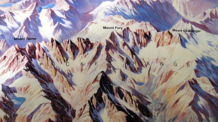
The labeling is looking really good. But I think Darin is correct about the following, which hasn't been fixed:
Hannegan Peak is mislabeled. Teh actual Hannegan Peak is straight right of Ruth. What you have marked is a subsummit of Sefrit
-
Sure, I'll kick in for one.
-
That's a bloody amazing picture. Has Mt Baker's summit ever been so bare of snow and ice in our lifetimes?
-
Your efforts have inspired me, Steph.
My mental image of the Cascades was influenced by the Berann panorama decades ago (it was pinned to my wall for years). So I think it's a perfect illustration to open my website series on skiing the Cascade Crest. I've replaced my old cover photo with an annotated panorama:
http://alpenglow.org/skiing/cascade-crest/index.html
You can click the image to view an enlargement.
Thanks go to Heinrich Berann for painting it and to the National Park Service for making it publicly available.
-
5. Teebone Ridge (or perhaps you could say Big Devil)
It's interesting that Berann emphasized the tooth south of Big Devil, which I believe is "Fallen Angel" as mentioned in this thread (click through for pictures):
-
In that line of thought, I've marked yellow circles on peaks I might like to add labels to since they seem to be emphasized. ANyone care to take a gander at what they are?
From left to right:
1. I'm not sure about the stuff around Tower and Golden Horn so I'm going to pass on this one.
2. Booker
3. White Chuck
4. Crater (Jerry Lakes are the giveaway)
5. Teebone Ridge (or perhaps you could say Big Devil)
6. Unnamed (Pk 6872 NW of Prophet)
-
When deciding what to label, I think it's important to take into account which features the artist chose to emphasize.
To use a crude analogy (too crude, really, for work as beautiful as Berann's) the panoramist is like a caricature artist. (You know, the artists at street fairs who create portraits in which the subject's head is like a balloon on top of a tiny body.) The panoramist chooses features to emphasize and other features, by necessity, are suppressed. This is described in the website that Steph linked to:
http://www.shadedrelief.com/berann/index.html
See especially:
http://www.shadedrelief.com/berann/landscape.html
Generalization
Considering how much time is spent making a panorama appear realistic, an inevitable question arises: why not just use an oblique aerial photograph instead? The answer is “generalization.” Aerial photographs typically show too much and/or inappropriate detail.
[...]
Berann sometimes selectively exaggerated the size of important landmarks. This creative license was done at the expense of adjacent or intervening terrain because only a finite space exists on a printed sheet. The sacrificed terrain is usually not omitted but minimized in its extent and functions to bond or connect the more important components of the landscape.
We should beware of putting labels on features that Berann himself didn't emphasize. I think Sahale Peak is a good example. It's really not shown on the panorama. Le Conte is another marginal choice. Cutthroat is there (I guess) but it's clear that Berann didn't try to really depict it. That seems true of all the peaks NE of highway 20, except Jack and Hozomeen.
On the other hand, look at Gabriel Peak, halfway between Mesahchie and Ruby. That peak is just begging for a label. Berann obviously emphasized it. It's hard for me to say how far you should go in labeling, but thinking of the work as a "caricature portrait" of the Cascades may help. Which peaks did the artist try to make stand out from the crowd?
Regardless of all that, I really want to thank Steph for digging up this digital image--in the public domain no less! This is a wonderful gift to the Northwest mountaineering community and a great opportunity to acknowledge Berann's legacy.
-
Lowell - nice beta for the corrections....now, for that NCNP boundary, is that marked on your version? I think for the most part it is correct on my poster.
The NCNP boundary is not marked on the original poster. I just sent you a hi-res photo of the whole thing by email. As my email mentioned, the original poster is quite large, 39x29 inches or 99x74 cm.
I just looked at your NCNP boundary and I do see some problems. Ross Lake is not in the park. It is in a national recreation area. Look closely at your topos and you'll see.
Also, the south unit of the park does not go all the way to Lake Chelan. That too is in a national recreation area. The southern boundary of the park runs from Agnes Creek over McGregor Mountain to Twisp Pass.
----------
Edited to add:
Perhaps the park boundary should be omitted. The original poster was labeled simply "The North Cascades" and the border said, "North Cascades National Park, Ross Lake and Lake Chelan Recreation Areas, Washington." Omitting the boundary would be consistent with the grand vision of the early conservationists, which had fewer man-made divisions.
-
It's time for a new edition for all the new North Cascades climbers out there, don't you think!
Yes, definitely. I think your version looks great.
Here are a few minor observations:
1. Your label for Mox isn't quite right. Mox is roughly below the 'S' in Spickard. ("Hardest Mox" is clearly visible, directly below the 'S'.) The peaks you've labeled Mox are SE of Bear Mountain on the SW side of Redoubt Creek. They are unnamed on the USGS topo.
2. The line drawn from the label for Primus Peak is pointing at Austera Ridge (Tillie's Tower, I believe). To hit Primus Peak, you need to extend the line to the next peak down.
3. Your label for Storm King points to the long east ridge of Mt Buckner. (Buckner does not seem to be well-rendered in the painting.) Storm King is accurately rendered just left of the intersection of a line extending down from the 'S' in Storm King and another line extending left from "Logan".
-
For what it's worth, here's a portion of the poster that was for sale in the 1980s. They used pretty small labels. Some of the labels weren't positioned just right. I bought my copy at the Marblemount ranger station.
-
Very nice. I had no idea that this was in the public domain.
Does North Cascades National Park still sell posters of this panorama? I have one that I bought in the 1980s when it first came out. My poster has the landform features labeled, but not as extensively as Steph's version.
-

Northwest Mountaineering Journal, 2009
The mission of the Northwest Mountaineering Journal is to be an edited, permanent, annual record of mountaineering in the Pacific Northwest. The journal documents the events, people, history and spirit of climbing and other mountain sports in this region. The journal is published by volunteers from the mountaineering community in collaboration with The Mountaineers. The 2009 issue of the journal is now available. See:
This issue has feature articles about alpine climbing, skiing, rock climbing, mountain rescue, bicycle mountaineering, peak bagging, and light-and-fast enchainments. It includes reports of new climbing routes and first ski descents from April 1, 2008 through March 31, 2009. It also contains highlights from North Cascades National Park.
New features in this year's journal include a built-in slideshow feature (click any photo to launch a slideshow). The Archive page (accessed through a link at the top of every page) now lists all NWMJ articles published since 2004.
I'd like to thank everyone who contributed stories, photos, and information for this issue, both for your contributions and for your patience as we assembled this issue over the past several months. I'd also like to thank the team of volunteers who edited the journal and The Mountaineers who provided invaluable support.
We hope you enjoy this issue and will begin looking forward to the next one.
The 2009 Northwest Mountaineering Journal Team:
Ralph Bodenner
Steve Firebaugh
Alex Krawarik
Matt Perkins
Rad Roberts
Lowell Skoog
Steve Smith
Curt Veldhuisen
Gary Yngve
Aaron Zabriskie
-
The way I remember hearing it, Croft intended to climb the south face of Prussik but because of his sun headache he settled for the west ridge. I don't remember where I heard that.
It seems likely that he would stay high and ascend Colchuck and Dragontail by their easiest routes to reach the Enchantment plateau. But I'm just guessing.
The part about dropping a couple thousand feet down to get water and climbing back up to Argonaut is something I'd forgotten.
Rainier guides in the 1940's
in Climber's Board
Posted
In my copy of the book there's a rather grainy picture of Chuck on p. 304.