


Lowell_Skoog
-
Posts
2524 -
Joined
-
Last visited
Content Type
Profiles
Forums
Events
Posts posted by Lowell_Skoog
-
-
Thanks for the story Matt. Great climb.
CAG-1 gives the dates of the climb as 12/31/1980 and 1/1/1981. Did Fred get the year wrong?
-
Ha! In New Zealand, they're called nutcrackers, and come sewn into a weight-lifting belt that you get with your lift ticket.
But still, why has this happened. It seems like too much of a conspiracy to blame large resort ski resorts.
No conspiracy, just superior marketing. Most people want things bigger and fancier. Those who didn't generally dropped out of skiing during the boom years. It was only after the little areas died of neglect and the big areas became much more expensive that a few people started to miss the little areas.
You should read "Downhill Slide" by Hal Clifford. Here are my notes on it:
http://alpenglow.org/ski-history/notes/book/clifford-2002.html
Fortunately, Washington has largely been spared the sort of real-estate-driven mega-development described in Clifford's book. But you still hear people complain sometimes that there are no "destination ski resorts" in Washington.
By the way, rope grippers are still used at the Mountaineers Meany Lodge. It must be one of the very few areas (I'm not actually aware of any others) that still allow them in the U.S.
-
Hi Chris,
You should go skiing at the Mountaineers Meany Lodge (formerly called the Meany Ski Hut) near Stampede Pass. It has been in constant operation since 1928. The first rope tow went up in 1938-39. I think Meany is probably the longest continuously running ski hill in Washington. It is definitely a club hill of the sort you're looking for. KurtF mentioned learning to ski there, but he didn't perhaps make it clear that the little hill is still going strong.
You should also check out the ski hill at Leavenworth, below the old jump hill. It doesn't always run, due to low snow cover, but when it does, it's a great little community resource.
Also, check out Loup Loup near Twisp. It's not a club hill, but it's definitely a community hill, with a different feel and philosophy of management. It's a delightful little area.
My feeling is that Washington's club ski hills generally didn't die due to liability. One noteworthy exception is the Mountaineers ski area between Snoqualmie Summit Central and Summit West. There was a fatality on the rope-tow in 1997. A 13-year-old boy got his clothing caught in the rope and was strangled. That was the beginning of the end. The Mountaineers permanently closed that tow a few years later.
Most club hills in Washington died because people preferred to ski at the larger, more developed ski areas. Some, like the Sahalie Ski Club have largely been absorbed by nearby ski areas (i.e. Summit West and Alpental). The other hills you mention, like Yodelin and Pilchuck died for complex reasons. They were not club hills. You can find notes about them on alpenglow.org.
If you want to find the little minimalist ski areas in Washington, you should go east of the Cascades. See the following article for information about six of them:
http://www.theolympian.com/2011/11/13/1874805/nows-the-time-to-tour-the-smaller.html
Also, don't forget Hurricane Ridge. That little area is a delight. It deserves everybody's support, because the Park Service is deeply ambivalent about allowing ski areas within the National Parks.
When I spent time in New Zealand, I was happily stunned by the number of ski club hills - tiny basins, often on logged or alpine terrain, utilizing rope tows. None had anything fancier than a warming hut at the base, with a club-run concessions stand. The biggest one I skied at had three rope tows - two linked together on the right side, and a third on the left.What happened here? There used to be two other ski hills on Stevens Pass, one on Pilchuck, and several others. You can find the list of KIA on Lowell's website. I also noticed this at Lake Tahoe when we lived there for a few winters, so is this a national phenomenon, or did something specifically change here in Washington?
I've never seen the little rope tow at the Sahale ski club run.
Some point down the line, I heard that it was safety regulations that became too burdensome. I even heard that the rules governing a rope tow are the same for a chair lift, gondola, and a tram, which seems a little ridiculous to me. But this is all hearsay. Does anyone know the facts? Lowell?
The cost of entry to skiing and snowboarding keeps getting greater. Lift ticket prices are spendy. Base areas sometimes seem over-developed, but many ski areas say that without that development, they can't afford to operate at all.
Is there room for minimalist non-profit ski hills today?
-
I don't know of anybody who has skied the Ptarmigan Traverse that early in the snow season. It is usually done in spring.
Going that early means short days, a thin snowpack and unconsolidated snow, most likely. You're likely to be much slower than in consolidated spring conditions.
Good luck if you go. Post a trip report. Or consider waiting until spring to ski it.
-
They also did [buck] in November so not really a winter ascent.
True. (Well, actually December 4.)
When I compiled my chronology, I broadened the scope to include autumn and spring climbs done under winter snow/ice conditions. This is mentioned in the notes at the bottom of the chronology.
This pulled in a number of good climbs on Greybeard, Cutthroat, Dragontail, Stuart, Eldorado, Shuksan, Summit Chief, and Buck. I don't know which of these may have been done in calendar winter.
-
And then what about the FWAs of Yak Crack and Yak Check, NE Ridge of Needle, etc?
...
Tomyhoi north face?
...
Nesakwatch Spires?
I don't see those in CAG. I also searched in my DVD copy of "Ever Upward" (CAJ 1907-2007) and didn't find winter climbs on these peaks. Where were these climbs reported?
-
Where are winter routes from CAG on Silvertip, Rideout, Sumallo, Payne, Pierce, Brice, Thar, Outram?
Thanks for those. I've updated my chronology. I've also updated my online essay somewhat. The essay can be found here:
http://www.alpenglow.org/themes/ncascade-winter/index.html
and the chronology can be found here:
http://www.alpenglow.org/themes/ncascade-winter/chronology.html
Obviously I didn't give enough attention to the peaks north of the U.S.-Canada border when I searched through CAG.
-
It's missing so much stuff I don't know where to start, Lowell. I see at least a half dozen routes just from the red CAG you don't even have in there.
That's not very helpful.
If you know of routes that are missing, could you please post them here or email them to me?
Start by starting...
-
Also, see the following list of routes not yet reported in CAG or NWMJ. I see only one FWA there. Eventually I'll update the winter route list from this.
http://www.mountaineers.org/nwmj/inbox.html
-
The list is not exaustive is it?
If this list is the same one (didn't check) from the appendix to John Scurlock's book then there is quite a bit missing.
Yes it's the list from Snow & Spire. But I've updated it since the book was published. Also, the list on line covers the entire range while the one in the book has only the North Cascades.
The list is as exhaustive as I could make it based on Beckey's guides and a few other sources. (See notes at the bottom of the page.) If you know of routes that I've omitted, let me know and I'll update the list on the web.
-
-
Way back when, I taught myself aid climbing on a chain-link backstop (in a baseball field). No pro needed--just clip the backstop. You can work out various systems without messing with protection.
I never did much aid climbing (and what I know is decades old) but that practice got me up a few local aid classics, like Town Crier and Liberty Crack.
-
Todd Warger sent me a note to say that the Mountain Runners film will be shown at the Tacoma International Film Festival on Monday, October 8, at 6 pm in the Grand Cinema.
The film will also be shown at the Vancouver International Film Festival on October 6, 8 and 11. (I assume that's Vancouver, B.C.)
No Seattle screening has been scheduled yet. For more information, see:
-
Early Winter -> Early Morning
Thanks for the TR.
-
NOLS does this traverse often. perhaps you should get in touch with them? From what I've seen watching them do it, you cross near the saddle on the SW ridge of Torment around the Pt. 6750 saddle.
It may have been a NOLS group that let my brother and me use their rappel anchor to cross the long ridge that I think Alex is talking about. Saved us the trouble of setting our own anchor.
-
Has anyone responding here actually done this route? The last time I traversed from Torment Basin to Boston Basin (June 2003) we did a rappel on the Boston Basin side of the spur that extends SW from Mt Torment. This was at about 6600ft elevation. Maybe the crossing gets easier later in the season, but I don't think it's ever just a walk-off. Anybody know different?
The alternative crossing is much higher, at the 7400ft notch in the south ridge of Torment. That's a relatively easy crossing when the notch is snow filled, but it can get trickier later in the season.
Bottom line: This section of the traverse may not be a simple as you're expecting.
-

New Routes in the Pacific Northwest (from NWMJ.org)
Readers of the Northwest Mountaineering Journal (NWMJ) may know that the journal has been without a lead editor since I stepped down in Autumn 2010 after the 7th issue was published. I'm too busy right now to lead the effort. Several volunteers have continued work on the journal, but progress has been slow. Since I'm not leading the effort anymore, I can't say when the next issue will appear.
For several years, the NWMJ editorial team has used a private wiki to collect information for the journal. Editorial team members browse on-line forums looking for new routes to add to the wiki.
Since we don't know when the next issue will appear, I've decided to make the editorial team's work more accessible now. I've added a page to the NWMJ website that I call the NWMJ New Route Inbox. Here is the direct link:
http://www.mountaineers.org/nwmj/inbox.html
This page is accessible from the top-level NWMJ web page. It is also available from the NWMJ Index of Short Reports.
The inbox contains every new route (that I know of) since NWMJ Issue 7 was published that may be suitable for the next NWMJ issue. The list has not been fully vetted by the NWMJ editors. Some routes might not be new or might not be within the NWMJ scope. Currently there are 95 prospective routes listed. We will continue to update this page as new routes are uncovered.
Publishing the NWMJ Inbox makes this historical information easy to find in one place and provides a way to get the facts right. The inbox contains just the critical information: date, route, party members, trip report link(s), and miscellaneous notes. If you have comments, additions or corrections to the list, please let me know. An email contact link is included on the NWMJ inbox page.
-
 1
1
-
-
I recall that Gary Brill and a friend climbed a route in that vicinity from Paradise in winter in the late 1970s. I'm surprised that Beckey's guide doesn't seem to mention anything on that side (based on a very quick skim of the book). I can't remember whether Gary ever wrote up his climb.
I checked with Gary and determined where he climbed. See photo below:
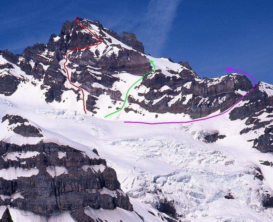
The red line on the left shows the Campbell/Gauthier route. The green line in the middle shows the route Gary Brill took way back when. The purple line on the right is the normal route from the Ingraham Glacier up Little Tahoma. Congrats on an attractive looking route.
-
I've climbed it three times. In 1978 I climbed it twice in a week. In 1985 I took my wife up it. There's a pretty easy route up the east face. But as I recall I always descended by rappelling the south face. Your mileage may vary.
-
Suggest looking at Google Earth. You may be able to get onto the Fryingpan Glacier from the Emmons, but no guarantee, and you'd have a lot of crevassed glacier to traverse. The two summits are not well situated for a link-up.
-
I've updated the topos for both Liberty Ridge and the south side of Mt Rainier on my website:
http://www.alpenglow.org/ski-history/topos/mt-rainier.html
Since the photo I posted above is linked to alpenglow.org, the new topo shows up here. Let me know if you see any errors.
I typically update my chronologies in the autumn (in one big batch) so that part of my website won't change right away.
-
I recall that Gary Brill and a friend climbed a route in that vicinity from Paradise in winter in the late 1970s. I'm surprised that Beckey's guide doesn't seem to mention anything on that side (based on a very quick skim of the book). I can't remember whether Gary ever wrote up his climb.
-
Sky did a similar line to this a few years back. I just can't quite tell the difference between the two descents though, any ideas?
I'm pretty sure the route Sky did was the one first skied by Chris Landry in 1980 and done by several other parties since then. That route descends the upper ridge on the east side of the crest, then crosses to the west side of the crest above Thumb Rock. The descent continues down NW-facing slopes between the crest of the ridge and Liberty Wall. You can see a topo of it here (3rd photo on page):
http://www.alpenglow.org/ski-history/topos/mt-rainier.html
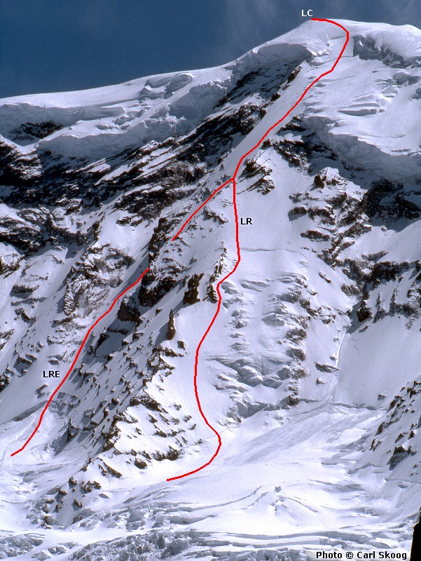
By contrast, the route in Oliver's blog post stays on the east side of the ridge the entire time. It descends between the crest and the Thermogenesis gully, which it joins near the bottom.
-
Was told by someone that I should get a hold of Lowell Skoog as he is the keeper of ski descents in the Cascades. Anyone know how to contact him?
Hi Oliver,
I saw this TR yesterday, which led me to your blog post. So, I think I've got most of the information I need. If you'd like to send other details, my email address is lowell.skoog AT alpenglow.org. I'd be particularly interested in the exact dates of your descents of both Nisqually Icefall and the recent Liberty Ridge route. I haven't heard of other ski descents of either route.
Congratulations on the Liberty Ridge descent. I watched your video and it looks like you had amazingly good snow conditions. Amar suggested that you should make up a cool name for it. A prosaic name might be "Liberty Ridge East." But if you wanted to get clever, how about "Cryogenesis?" (Sort of a companion to Thermogenesis....)
====
At the risk of being morbid, I think your descent route was the line of David Persson's fatal fall in 1999, which Drew (G-spotter) mentioned above:
http://alpenglow.org/ski-history/notes/book/harlin-2001.html#harlin-2001-p113
First Ascents 2012
in Climber's Board
Posted
I think Matt is already aware of it, but this page lists the potential new routes that I've recorded since the last NWMJ was published in 2010.
http://www.mountaineers.org/nwmj/inbox.html
These routes haven't been vetted by NWMJ editors. There may be some that wouldn't be published if we did a full-blown editorial review of them.