-
Posts
32 -
Joined
-
Last visited
-
Days Won
11
Everything posted by adventure43
-
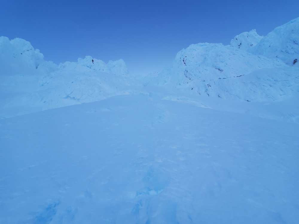
Trip: Middle Sister - East Face Trip Date: 06/05/2020 Trip Report: Images: https://imgur.com/a/2r8kVaa Anyone else do this route, #14 from Jeff Thomas's Oregon High, or #15a East Arete? Seems there are no modern TRs. 9:15 PM start 10:15 PM Camp and Green Lakes trails intersection Midnight above normal camping area just out of the woods 2 AM Above final moraine 4:30 AM Above the East Face on SE Ridge 5 AM Summit A couple of weeks ago I got a good image of the East side of Middle Sister and the #14 East Face, green line, and #15a East Arete, blue line, routes looked good, https://i.imgur.com/7lj8kNl.png. Figured it was best to have a go before the next storm cycle this weekend. This, https://i.imgur.com/toFrlVF.jpg, gives the best (though still crummy) shot of the actual route, see the center left snow ramp. This was the first time for me on the Diller Glacier. It sure is nice to have such an easy approach, no steep moraines to navigate. Unfortunately, the moon was obscured in the little bowl that is the East Face and all the pictures I took didn’t turn out. Oh well, I’ll try to describe things. After getting up the lower ramp, I looked for a way to get past the bergschrund. In the darkness I thought I saw a way to get up on the far left but that was a no go. Traversed to the center and there was a super crappy ramp that had next to no support in the middle – nope. Tried to traverse a bit more to the right and found gaping holes in the snow and the rock under my feet like there were multiple bergschrunds. I think the snow and rock was debris from the bergschrund and or crap from previous avy events. I down climbed a bit to keep out of danger and then finally went all the way to the right and found a decent ramp right next to the cliff. I hadn’t seen or heard any rockfall from the cliffs but still, not the greatest place to be. Stayed close to the cliff, and I think there was another bergschrund but it was to the left of the cliff. Got in a moat-ish depression and followed it up probably less than 50 feet until it ended in crap snow and 3-foot hole next the cliff. Traversed left and got into a multiple foot wide runnel. Another 50-ish feet up, this ended too. With more leftward traversing, finally got somewhere near the middle of the face and away from the cliff – big relief. The snow up to that point was fairly firm and even required swinging the tools to get penetration. This didn’t last too long and soon I was just pushing the tools in. The crampons previously weren’t penetrating too deep but now, if I kicked a bit, the 1 – 1.5-inch crust broke. There was probably 3 – 4 inches of not complete fluff underneath but definitely not well consolidated either, bleck. The crust never sounded hollow but breaking through it seemed to cause some sort of vibration, or at least, it didn’t sound great to me. I climbed as gingerly as I could to stay on the crust and not cause a slide. The rest of the climb was fairly easy. The slope was probably 30 – 40 degrees. There were some open holes in the snow further up but they were easy to navigate around. I angled to the left a bit and got up to the SE Ridge, happy to be out of harm’s way. Had the summit to myself and watched the sunrise from further down the standard route. The wind was non-existent except on the very edge of the SE Ridge and the summit, maybe up to 25 MPH. Ran in to the climber that camped the previous night and chatted a bit on the ridge above the Hayden Glacier. This route might be fun when in condition but that probably won’t happen until next season. Gear Notes: Helmet, crampons, axe (didn't use), 2 tools Approach Notes: Normal Middle / North Sister approach except stay to climbers left coming up the final moraines and then veer left to get to the route - see attached GPX.
- 1 reply
-
- 1
-

-
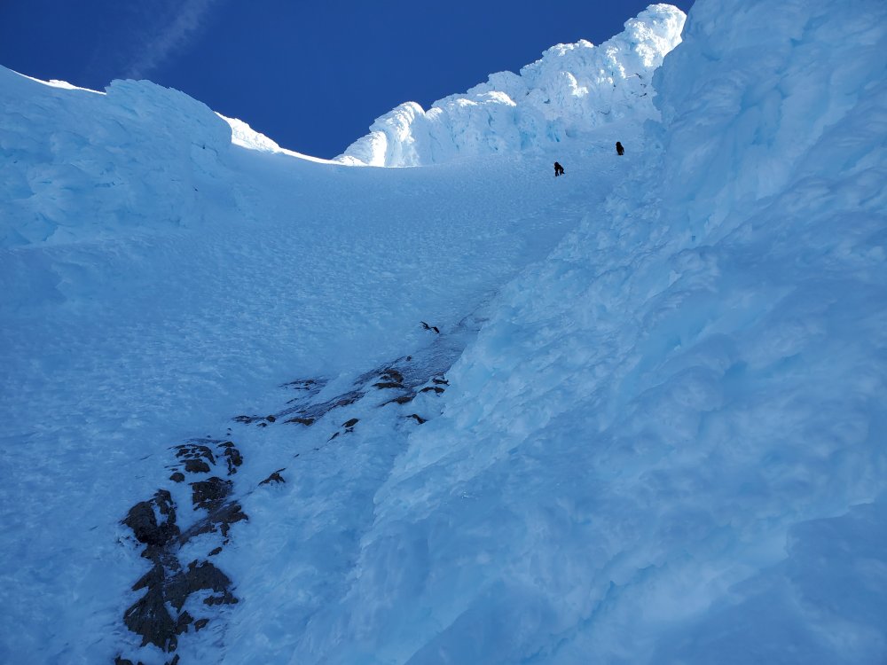
Trip: South Sister - Silver Couloir Trip Date: 05/25/2020 Trip Report: Images: https://imgur.com/a/5vQUocK 9 PM start 11 PM pass North / Middle sister climbers trail on Camp Lake trail 12:45 AM Camp Lake 5 AM base of the climb 7 AM heading down from North Face Couloir 8 AM top of Silver Couloir 8:45 AM Summit Thanks ScaredSilly, Drocka, et al. for your trip reports on South Sister. Maybe you could name the route you took The Fin for the rock near the bottom of the route. https://cascadeclimbers.com/forum/topic/101689-tr-south-sister-north-face-05222018/ https://cascadeclimbers.com/forum/topic/101726-tr-south-sister-north-face-of-northwest-ridge-nfnwr-06262011 My intention was to climb the North Face Couloir. https://imgur.com/a/aPEHYwd showed good snow coverage over the rock bands. I’d watched the radar in the middle of the week for South Sister when it was forecast to get 7.5 inches of snow and it seemed like it rarely got any. My brother’s old skiing and climbing friend skied Mt Bachelor on Friday and said there was 1 – 1.5 feet of new snow on top of a solid base. One day of sun, Friday, was surely not going to consolidate that. Brother skied Mt Hood on Saturday and said there was decent climbing conditions. Hmm, well, it was forecast to warm up on South Sister in the next week so I figured I may has well try now as it probably wasn’t going to get any better the rest of the season. Drove down Saturday afternoon and was on the trail by 9 PM. Started out in a sun hoody, warm gloves and an ear band, added a hat an hour in, fleece top three hours in and then finally a thin wind jacket after getting out of the trees. It was cool with little wind. The approach from Pole Creek was the normal dusty trail for the first few hours with lots of logs and a few downed trees giving way to snow and non-dead trees later. The lower snow was compact and easy to walk on, the new snow, higher up was, as expected, not consolidated. Most of the way over this was fine, nice to have some cushioning when walking in mountaineering boots. As I climbed out of Camp Lake the unconsolidated snow got deeper, maybe six inches and I put on crampon. It was still very dark, new moon that morning, when I checked Gaia to find I’d slightly overshot the turn to start climbing up to the route but was able to go up a bit and traverse left to get there. Heading up the canyon, the snow just got deeper and was still not consolidated. I stabbed the axe down to the hilt with my right hand, pushed the blade of the tool as deeply as I could with the left, kicked in hard and pretended things were going to be fine even though nothing was solid but the snow was holding my weight. Getting up the first rock band was no problem and to the bottom of the second, not much more than traversing right and left to take the best route. The start of the second band required getting over a couple of, not too large, rocks. To my surprise I was able to get a solid tool placement above the rocks and hoisted myself up while pushing off another rock. The upper part of the second band was a different story. The rocks were bigger, steeper and partially covered in ice. I swung the tool hard twice into the exact same spot on a rock covered in ice and got nothing more than an inch-wide divot, no penetration at all. I tried a couple of other spots and reaching around the rock to see if I could hook something but it was too large. Looking up at the final rock band, I resigned that even if I could get above the immediate rocks, there is no way I’d be able to climb to the top this way. My original hope was that the snow just to the right of the final rock band face wouldn’t be too steep and I’d find a way up. Not a chance, there was hardly any snow on the rocks, just a wall of rock and boulders covered in ice. After down climbing a bit, I traversed left, staying close to the rock cliff, and went up the Silver Couloir. This was as advertised, a straightforward steep snow climb. The last 10 feet were very steep and kicking in was more like kicking in my entire lower leg. The lower angle slope to the summit ring had a bunch of unconsolidated snow too but there were areas that were actually firm. After talking to the only group on the summit, I headed southward along the rim and started heading down. The snow was now sticking to my boots and gaiters making massive clown shoes. Not too long later I see a guy on the summit ridge in a Grivel helmet. He says he just climbed the Silver Couloir too. He thanked me for making steps and asks to exchange info so we could do the N Face Couloir next year. Any other time I would be like, heck yeah, that sounds great but I’m completely defeated and want nothing to do with that thing and think no one should climb it without a top rope or years of ice climbing experience. Shoot, I was way too literal in my thinking and missed the chance of finding a great climbing partner. He even offered to makes steps down the North Ridge which he did and I followed but he was long gone by the time I got over there. The walk back to Pole Creek TR was like experiencing a dream where all my movements were slow and painful. I just tried to keep moving and think I’ll get back eventually. The thought of chocolate covered almonds made the idea of driving 3+ hours home bearable. I’ll remember this one for a while. Maybe do a route on the Prouty side next? Gear Notes: Helmet, crampons, axe, 2 tools (only used one) Approach Notes: The normal dusty trail for the first few hours with lots of logs and a few downed trees giving way to snow and non-dead trees later
- 1 reply
-
- 3
-

-
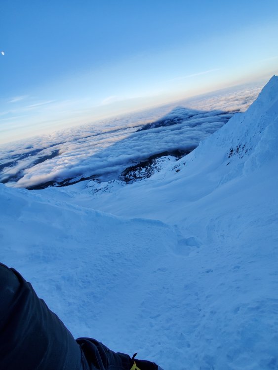
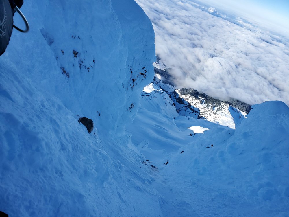
Trip: Mt Hood - Sunshine from Timberline Trip Date: 03/19/2020 Trip Report: ~33 F, clear and no wind to start. Only a few gusts heading up to Palmer. Even though it was forecast to be 14 F at night on the summit and fairly cold below, the puffy stayed in the pack. So nice not having 20+ MPH winds, first time for me this year. The traverse over was about expected, crappy but not horrible with a good amount of foot wrenching and wondering how much longer I’ll do these kinds of routes. The foot and a half of unconsolidated snow on part of the Newton Clark was concerning. Instead of following the normal climbing route up to the Spur I stayed a bit lower. This worked out fine, the climb up to the spur wasn’t too steep. Found the approximate spot to start the downclimb to the Eliot, https://imgur.com/a/dgOh8hj, that I’d spied on my previous Cooper Spur climb. The top part was fairly solid but became less so further down. About 30 feet from the bottom, my right foot poked through a hole. I could see a rock and a little bit of black down there – not horrible but not good either. Got the leg out and put knees and feet above the snow and froggied down the rest. My original plan was to head up the left side and cross the Eliot on the top shelf above the ice fall. Given that there was a bunch of unconsolidated snow on Newton Clark and I’d never crossed the Eliot, I decided to stay low and headed toward the lower ski circumnavigation route. To my surprise, the Eliot seemed mostly featureless and safe – yay. I altered my course a bit and just headed mostly straight across and up which took me to the ski route not far below the Sunshine route. Caned from there all the way up to below Anderson Rock. There looked to be a small bergschrund on the left below Snowdome but I didn’t investigate. Anderson Rock was guarded by a mess of small bergschrunds. I got up the first one and had to search to get over the second. Someone else was up there previously but I only saw their steps heading back from where I came. The second one was worse / sketchier. Climbing through the rocks and ice was fun but definitely not something for a solo beginner. The bergschrund below Horseshoe rock, at first glance, looked like it went from the Headwall all the way over to Cathedral. I figured I may as well get closer and to my surprise, just to the left of a big snow wall / formation, there was a small decent ramp that led directly up through Horseshoe Rock. The ramp was short, 10 feet probably but the climbing above it was challenging. Earlier in the year I accidentally did the Reid Headwall and popped out above the West Crater Rim route. That was challenging, but this section was harder, maybe not quite as steep but there was no place to rest. Thanks to all the climbers that have put in the boot pack from above the Queen’s chair to the summit ridge. So much easier than post hole-ing through the unconsolidated snow on the right or me doing a crappy job of navigating through the ice on the left. https://imgur.com/gallery/LkUPX3C 8:50 PM Climber's Lot 10:45 PM Top of Palmer 12:00 AM On a ridge past White River Canyon 3:00 AM Start heading down to Eliot Glacier from Cooper Spur 4:45 AM At intersection of the ski circumnavigation and Sunshine route 6:20 AM Below Anderson Rock 7:15 AM Above Anderson Rock 8:00 AM Start up ramp over bergschrund on Horseshoe Rock 8:50 AM Over Horseshoe Rock 9:50 AM Summit ridge 10:20 AM Summit 1:40 PM Car Gear Notes: Helmet, axe, 2 tools, crampons Approach Notes: Crappy but not horrible
-
[TR] Mt Hood - Cooper Spur from Timberline Lodge 02/27/2020
adventure43 replied to adventure43's topic in Oregon Cascades
Unfortunately, I didn't get to see it much at all, it must have been around 3:45 AM that I passed that area. -
Trip: Mt Hood - Cooper Spur from Timberline Lodge Trip Date: 02/27/2020 Trip Report: Followed https://caltopo.com/m/15S0 10:40 climber’s lot 12:30 top of palmer 1:20 headed down white river canyon 4:45 on spur 6:00 just below chimneys 7:50 summit Traverse between the bottom of White River Canyon to half way through the rocky section between it and the Newton Clark had embedded chucks of ice in a crust of ice and compacted snow. Used tools where I expected instead to make quick progress canning over. Luckily it was firm to sinking only a couple inches on the Newton Clark. The ramp up to the spur was very gradual and no ice at all on the spur. Waited around for daylight before heading up. Nothing was coming down from above which was nice. Mostly firm snow on the spur but unconsolidated fluff near and through the chimneys, worst 20 feet before the exit / where the grade eases up, maybe 1.5 feet deep. No cornice over the summit. Down climbed the Old Chute. Images https://imgur.com/gallery/t3DYo6C Gear Notes: Helmet, axe, tools, crampons Approach Notes: Chewed up cat snow to top of Palmer, crap on White River, nice on Newton Clark.
-
Trip: Mt Hood - Reid Glacier Headwall Trip Date: 02/12/2020 Trip Report: Solo'd and went slow, started 2:45, at saddle 5:45, topped out on West Crater 9:45, summit via Old Chute 11 AM. Planned on doing Leuthold but that didn't work out. Would have been nice to have brought another tool but the axe worked well. Climbed down from the saddle facing in since it was still dark but it wasn't that steep. Didn't see any crevasses at the bottom. Climbed over a mostly covered bergschrund near the bottom of the ramp without breaking through. The gullies were reasonably filled with firm snow and some ice, not too steep. Saw two climbers above me to the left near the bottom, they cruised up but made sure I made it out. Pick sticks and foot kicks were solid the whole way up. West Crater was softening quickly but the Old Chute was still hard even coming down. More stitched together images here, https://imgur.com/a/Lj07ROr. Gear Notes: Helmet, 1 tool, 1 axe, crampons Approach Notes: High 20s F, 30 MPH winds