-
Posts
51 -
Joined
-
Last visited
-
Days Won
32
Everything posted by Eric Gilbertson
-
 Thanks! I put together a video that has some of the towing here, though the snowmobiling is all in the dark. Seems like I only ever snowmobile in the dark for these trips. I think I probably just need to get more skilled at snowmobiling to be comfortable going off-road, though with three people on the sled I'd be nervous getting through any tricky terrain.
 -
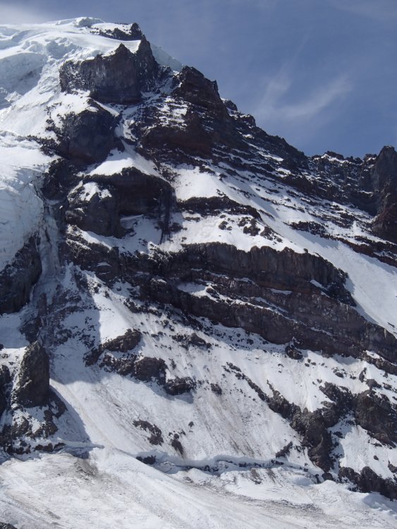
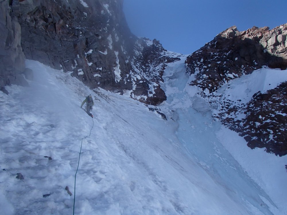
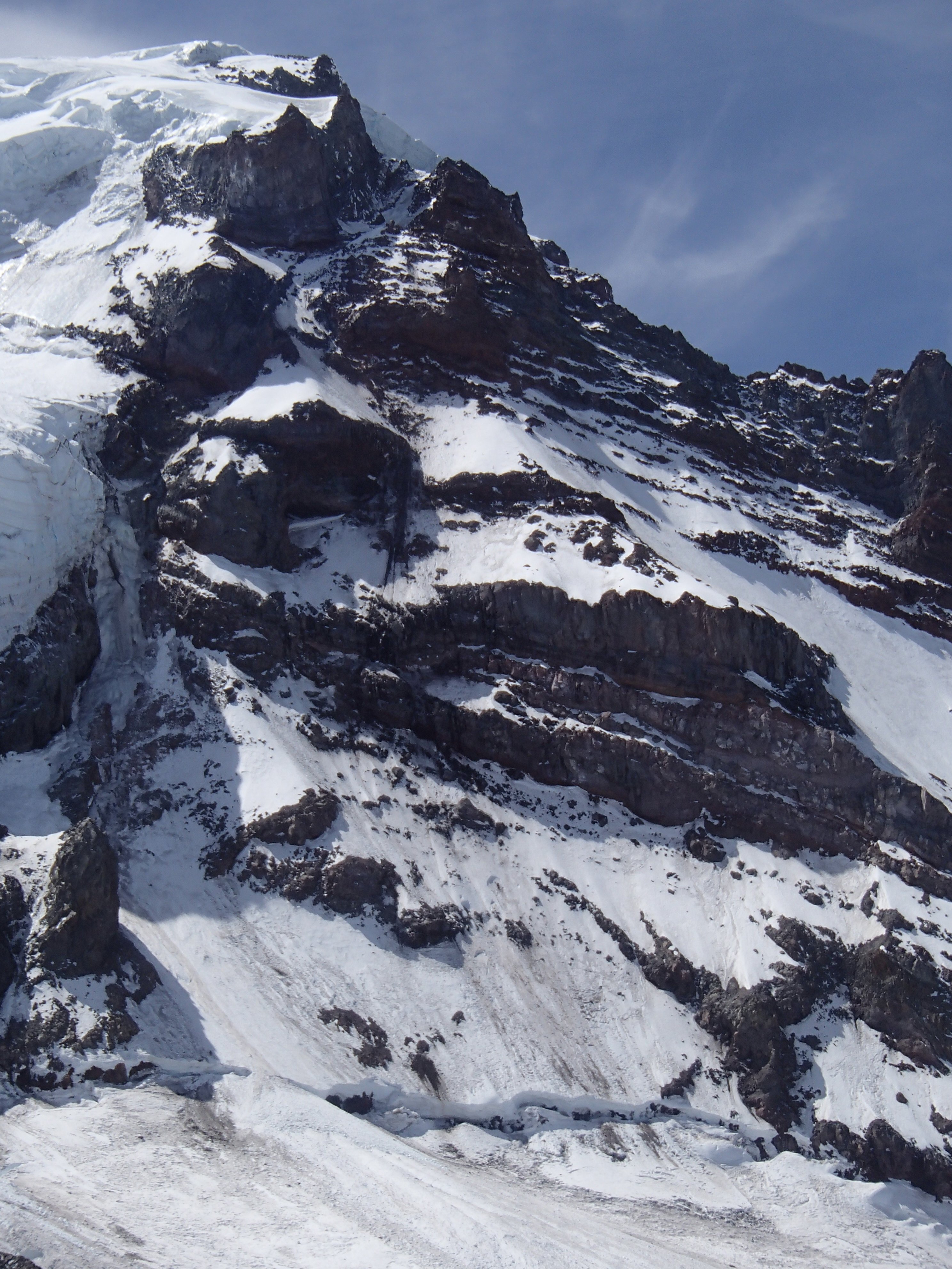
Trip: South Spectacle Butte - SW Ridge Trip Date: 02/25/2023 Team @Eric Gilbertson Trip Report: South Spectacle Butte (8,392ft) 60/100 Winter Bulgers Feb 25, 2023 Eric, Anthony, Andrew 22 miles hiking, 25 miles snowmobiling 3:30am – 1:30am Andrew belaying my down from the summit (photo by Anthony) South Spectacle Butte (SSB) is a Bulger peak nestled deep up the Entiat River drainage in the east central cascades. It is high enough to be among the hundred highest peaks in washington and is thus on my to-do list for the winter. I’d previously climbed South Spectacle Butte in September 2017 and remembered it as a fun scramble with a few exposed moves. I couldn’t find reports of previous winter ascents but I suspected it would a much more difficult climb when covered in snow and ice. The route In December 2020 Fred and I had skied nearby Pinnacle Peak and contemplated tagging on South Spectacle Butte since it looked so close, but decided to leave it for the future. On that trip I got some pictures of the south face that would be valuable for planning a future winter mission. There are two main approaches to climb SSB. The first is to start at Phelps Creek trailhead and hike over ice lakes to access the standard southwest ridge route of SSB. This requires a 23-mile snowmobile approach and 20 mile round trip hike. The alternative is to snowmobile in 12.5 miles to the Cottonwood trailhead up the Entiat River then do a 22 mile round trip hike. While the Cottonwood approach has a bit more hiking, it has the advantage that it doesn’t cross any avy terrain to get to the base of SSB and has much less elevation gain. Anthony and Andrew were interested in joining and we made the final call on the objective for the weekend after the Thursday evening NWAC forecast. This peak would make an excellent ski objective, but I’m trying to reduce chance of injury before a spring expedition so we decided to all snowshoe. It looked like some bad weather coming in Sunday so we decided to do the trip as a single push Saturday. We would bring a 60m rope and light rock rack just in case the exposed bits I remembered warranted roping up. In general I’ve found if something is 4th class or exposed 3rd class in summer it generally warrants roping up in the winter for me. Leaving the sno park at 3:30am Friday evening I discovered my avy beacon was broken, so I made a last minute purchase of a new one at a nearby shop then headed out. I made it to the Entiat Sno Park at 10pm and managed to get a short nap in before our midnight meetup time. Andrew was there at midnight, but unfortunately I had screwed up my trip plan document and Anthony was at a different sno park! Luckily we sorted things out and were all at the correct sno park a few hours later. By 3:30am we had my snowmobile all loaded up and headed out. Andrew would wear ski boots and get towed in then snowshoe the hike with us so we could most efficiently split trail breaking duties. We rode up the freshly-groomed road with me and Anthony on the sled and Andrew getting towed behind. I kept a constant 20mph speed, which I’ve found is the sweet spot for towing. A little bit faster and I tend to lose the skier behind me, and any slower and the ride takes too long. Andrew wore my bike-tube belt with 3-1 z-pulley setup for a hopefully smooth and comfortable experience. First views of the peak We made good progress up the road, and after the Duncan Hill turnoff we appeared to be only the second set of tracks on the road since the 2/17 groom! There was one major tree across the road but I was able to ride around it and didn’t need to get the chainsaw out. After 45 minutes we made it to Cottonwood trailhead. I took a few loops around the lot to hit the high RPM bands then we all unloaded. The trailhead register didn’t have any sign ins since October but I was sure to add our names. We were soon heading up the trail, which was surprisingly easy to follow in the dark. It appeared a few snowmobilers had gone up the trail not too long ago, making a nice trench that was easy to follow. At the ice creek – entiat river confluence I suppose I could have easily continued a ways up the trail on the snowmobile (it’s legal since it is not wilderness), but I’m following a self-imposed rule to only take motorized transport to the trailhead for winter Bulger climbs, and do human-powered transport beyond that. Amazingly the snow was very well consolidated. It was basically a firm icy base with just a few inches of powder on top – dust on crust. So we managed to average around 2mph! That certainly helped make up for any lost time a the sno park. Usually in winter I estimate around 1mph breaking trail through deep snow, as had been the case a few weekends earlier in the next valley over climbing Dumbell and Greenwood peaks. We alternated leads and the snowmobile tracks ended a few miles in near the Duncan Hill turnoff when the terrain got steeper. The trail was still pretty easy to follow. Just before sunrise we’d passed Myrtle Lake and got our first glimpse of SSB in the pink alpenglow. This is one of the rare peaks that presents itself well in advance and we all appreciated the views of the route. It looked incredibly steep, but I knew the foreshortening was likely deceptive. Hiking up At the ice creek – entiat river confluence we left the trail and headed up the ice creek drainage. Travel was easy in the open forest and we made good time. The snow got slightly deeper above 4500ft but not enough to significantly slow us down. My original intended route had been to spiral around to the northwest side of the peak to gain a low-angle basin that was the standard summer route. But with the snow conditions were stable we decided to make up a little bit of lost time by taking a slightly more direct route. On the southwest face we found a route on mostly mellow tree-covered slopes that would be safe from avy danger. I led the way snowshoeing up the slope. Nice views back towards Ice Box, Freezer, and Maude As I got higher the clouds started to dissipate and the sun actually felt very warm. Andrew was even delayering to shorts and a T-shirt, though I didn’t go quite that extreme. We got excellent views of Ice Box and Freezer peaks across the valley, and eventually of Maude and Fernow farther to the north. Starting across the crux gendarme (photo by Anthony) We eventually reached the skyline ridge at 7200ft and stopped to take off snowshoes. The ridge was scoured down to rock with icy snow nearby, and crampons were the right tool for the job. I led the way up a bit to 7400ft, then traversed right around the first gendarme following my old GPS track. The snow was well-consolidated and stable, with only a few small isolated pockets of 3inch wind slab that was very stubborn to trigger. I rounded the south face of the gendarme then kicked steps up the steep snow slope to the base of the next gendarme at 7,700ft. This was the crux I recalled, and it also required traversing around on the right. I got up to the edge of a flat subsidiary south ridge bench with a small tree on it and stopped to scope out the route. The slope was very steep and exposed to get around the gendarme, but after that it looked much more mellow. I actually saw a small cairn poking out of the snow on the traverse, and this confirmed it was the correct route. I was certainly happy to have the rope for this climb in those conditions. Partway across I volunteered to lead and I was soon racked up and we had the 60m rope flaked out. Andrew tied on to the tree and started belaying me over. The plan was Anthony would tie in the middle and if the rope reached the other end I would belay him across, then he would belay Andrew across on the other end. If the rope didn’t reach all the way around we’d just simul climb across. I got in a solid cam at the start of the traverse, then carefully kicked steps in. The snow was nice and consolidated, but it still felt good to have the security of the rope and gear placements. I got in anothe piece just before the steepest bit, then I made a delicate traverse above big exposure. I carefully kicked steps in the snow and rounded the corner. Then I got a solid nut in and continued on sligthtly easier terrain. Anthony following across I continued traversing while digging out snow with my hands and knees before kicking steps in. I got in a few more good cams but then ran out of rope. So Anthony followed behind simulclimbing. Soon I reached the mellower ridgecrest on the other side and built an anchor with a cam and my ice axe. I belayed Anthony over the rest of the way then he belayed Andrew over. The ridge above us looked mellow enough to do unroped, and I didn’t recall anything particularly worrisome beyond that traverse. But I’ve been burned too many times in the past thinking the difficulties were over and ditching my climbing gear. So I made the call that we should still take the rope and rack up just in case it was necessary higher up. I started kicking steps up the slope while Andrew and Anthony coiled the rope and sorted gear. I made it a ways higher, but then the terrain became a very steep and exposed snow slope on the south side, which is the standard summer route. The north face was a sheer cliff. The ridge crest proper looked safe, with exposed rock, but would definitely warrant a rope. Climbing up the ridge I stomped out a platform just below the exposed part and let Andrew and Anthony catch back up. We were getting close to the summit, but were also starting to get short on time. The three-hour delay in the morning had put us a bit behind schedule and I was nervous about summitting before sunset and before the storm rolled in. So we decided to simulclimb the remaining ridge all the way to the summit. This would be much faster than pitching things out. I took all the gear, built an anchor in some rock, and was soon climbing. I kicked steps up to the ridge and had to scramble up some icy rocks to reach the crest. I got a cam in there then followed the edge of the rocks near the crest. A bit farther I got a solid picket placement, then continued. Soon I ran out of rope and Anthony joined, and he was then followed by Andrew. We took our time, and I was generally able to have at least two pieces between climbers at all times. Crossing onto the north side (photo by Andrew) Around 8000ft the south side looked very steep and sketchy and I crossed over to the north side. This is definitely not the summer route, but the north face was scoured down to rock and offered better gear options. Luckily it wasn’t quite as steep up at that elevation. I eventually wove back onto the south face to get around the highest gendarme, then on the other side I gained the final knife-edge snow ridge leading to the summit. The final knife edge before the summit After about five ropelengths I made it to the snowy and flat fore-summit and built and ice axe anchor to start belaying. It was very windy by then, and I think the evening storm was approaching. Mt Fernow had been stuck in the clouds for the past hour and Mt Maude was just starting to get cloudy. I imagined SSB would suffer a similar fate soon and I didn’t want to be there when it happened. On the summit (photo by Andrew) Andrew soon followed, then we switched roles so he belayed Anthony up. I then carefully made my way over to the true summit. The east face of SSB appeared to be a huge cornice but the west face was scoured to rock. So I made sure to tiptoe just on the rock. Interestingly the summit cairn was actually exposed, so I was certain I tagged the highest rock and didn’t need to go near the cornice. I hastily dug around but had no luck finding the summit register. This is pretty common on winter Bulger climbs. On the summit As I headed back as Anthony reached the foresummit. We exchanged high-fives and took turns going over to tag the summit cairn. It was 4:30pm by then and we had an hour left of official daylight. That meant the lighting was getting very colorful, but we were also getting short on daylight. I really wanted to be off the technical section before getting hit by darkness and the storm. We snapped a few final pictures, then I took all the gear back and Andrew started belaying me down. Climbing back down (photo by Andrew) I carefully walked down the knife edge, then started puting gear in. The ridge wasn’t steep enough to rappel so we would need to simulclimb the whole way back. The return would be much faster, though, since I’d already kicked steps in and I remembered all of my previous gear placements. As before I got in generally two pieces per 30m rope section. I got in a good variety of cams, nuts, pickts, slung horns, and the occasional slung bush. We were very effifcient going down, and even stopped to take occasional pictures of the brilliant sunset over Glacier peak and Mt Maude. Climbing back down (photo by Andrew) Back at the edge of the crux traverse we stopped to regroup and I collected all the gear back. Andrew then belayed me back over. I put gear in the exact places as before, and was soon around the exposed corner and back to the tree belay. Anthony and Andrew soon followed, and we all made it across with a little bit of daylight still to spare. From there we downclimbed the snow slope, traversed around the lowest gendarme, then followed the ridge back to our stashed snowshoes. By then it was finally dark enough to need headlamps. I’d say our timing was perfect, since we were up on the summit ridge at the right time to see a great sunset, but still got off the technical part before we needed headlamps. Heading down in the dark As we were packing up the snowshoes the wind picked up and it started snowing. That was the start of the storm coming in. We finished up quickly then cramponed all the way back down to the trees. That would have been a fun line to ski, though the patches of breakable crust would probably be challenging. Back in the trees at 5200ft we transitioned back to snowshoes and started cruising down the trail. The rest of the hike out was cruiser snowshoeing on autopilot. It was nice to not have to think about navigation at all – just follow the up tracks. At lower ice creek I stopped at an open hole to go fishing for water. I tied my nalgene on paracor to the end of my hiking pole, tossed it in the water, bobbed it up and down, and reeled in a nice full liter. The rest of the hike out went smoothely, and we reached the trailhead by exactly midnight. There were no other snowmobile tracks in there, and I guess it’s not a super popular location. We were soon loaded up and Andrew had his skis on ready to get towed. I started slowly then eased up to 20mph and started cruising out. Back at the sno park (photo by Anthony) The ride out went smoothely, and I saw a lot of fresh snowmobile tracks going up the Duncan Hill turnoff. The road was still nice and smooth, and by 1:30am we were back at the sno park for a 22 hour round trip. Anthony had to be at work that morning so soon headed out. Andrew and I ended up just sleeping a few hours at the sno park before heading home in the morning. Link to more pictures: https://www.countryhighpoints.com/south-spectacle-butte-winter-ascent/ Gear Notes: Rock pro to 2", 2 pickets, 60m rope Approach Notes: Snowmobile from entiat sno park to cottonwod trailhead
-
My understanding is the UN recognizes Antarctica as lands south of 60 S latitude. Heard and McDonald Islands are around 53S latitude so they are recognized as Australian territory by the UN. So I consider Mawson Peak as the Australian highpoint. Sounds like a fun peak! I've looked into it a bit. It'll take a 2-3 month expedition sailing from south Africa or Australia.
-
Thanks! Yes you're right that there are many possible definitions for a country. People certainly debate this. I go with the UN definition since it seems the most defensible. So I define countries as UN members and observer states plus Antarctica. This covers all land on earth. There are 193 UN members plus two nonmember observer states (Palestine and Vatican city/Holy See) plus antarctica so 196 total. This is consistent with what Guinness world records and explorers web recognize as countries. I define the highpoint as the highest point of natural rock, dirt, snow, or ice on any land owned by the country excluding foreign embassies. So, for instance, the Denmark highpoint is gunnbjorn fjeld in Greenland since denmark owns Greenland. The UK highpoint is Mt Paget on south georgia. And, like you said, teide in the canary islands is the Spain highpoint. I don't recognize country terrotorial claims to parts of antarctica since the UN doesn't recognize these. This affects UK and Australia. And I don't count termite mounds even though they are dirt and sort of natural since not man made. This only effects gambia. If you count those the highpoint location could change every few days! Thanks! Yes Washington is an excellent location to train for peaks like this! I think winter mountaineering here is especially helpful.
-
Thanks! Haha, Andreas is definitely very frugal. You should see his nose guard. Instead of buying a regular $10 noseguard he would slide a snickers wrapper under his ski goggles. It actually covered a bit of his cheeks too, so probably more effective than mine. And he could replace it each time he ate another snickers bar. You can see it if you zoom in on the picture of him on top of Broad Peak.
-
Trip: K2 - Abruzzi Spur Trip Date: 07/28/2022 Trip Report: K2 (28,261ft) Highpoint of Pakistan Second highest Mountain in the world July 28, 2022 Eric Gilbertson and Andreas Frydensberg No supplemental oxygen, independent unguided climb K2 as seen from basecamp June 13 – July 19 – Acclimate by climbing Broad Peak (26,414ft) July 20 – 22 – rest in broad BC after climbing Broad Peak July 23 – move to K2 BC in afternoon July 24 – climb to C2 6700m (I got hit by a big rock on the way up dislodged by descending climbers and was limping for next few days) July 25 – move to c3 7200m, evening summit plans thwarted by 20cm new snow so slept there in friends tent with only one sleeping bag July 26 – more unexpected snowfall, spend another night in c3 with no sleeping bags. We found an abandoned tent to shiver in all night. Food basically zero since we were delayed and ran out. July 27 – move to C4 7800m after weather cleared, then start up bottleneck 11pm in snow squall. July 28 – reach summit 8611m around 8am. We kept up with oxygen climbers most of the way. On descent I helped rescue two climbers near the bottleneck. Descend to c1 6000m in dark before a snow storm hit so stayed there for the night. July 29 – descend to K2 Basecamp 5000m July 30 – Aug 7 – hike out, drive back to Islamabad. Location of K2 K2 has a reputation as being the hardest mountain in the world. It is nicknamed the “savage mountain” and the “killer mountain”, and before this year it reportedly had a death rate of around 25%. K2 was first climbed in 1954, and by 2021 had only seen around 500 ascents. Many factors make K2 difficult. It is nestled deep in the Karakorum and takes nearly a week of trekking just to reach its base. In fact, it is so remote that there did not exist a local name for it. Surveyors gave it the name K2 for Karakorum 2, and the name stuck. It is the second tallest mountain in the world and the oxygen content is low enough at that height that most climbers will need to breath supplemental oxygen. Our route from Skardu The easiest route, the Abruzzi Spur, is very technical. The weather is notoriously bad with cold temperatures and extreme wind. I’m working on climbing the highest peak in every country on earth and K2 is the highpoint of Pakistan, so I needed to climb it. I’ve been working my way up increasingly higher and more difficult peaks over the years in preparation for a climb like this. Closer view of the route My first big peak was Denali in 2010. I gained more experience at high altitude and cold peaks with Mt Logan in Canada and a bunch of 6000m peaks in South America like Aconcagua, Ojos del Salado, and Sajama. I’ve gained technical experience over the years putting up a new 30 pitch rock route on Mt Nirvana in NWT, climbing a mixed route on Noshaq (7492m) in afghanistan, and a long ice route at altitude on Shkhara in Russia. Last summer, 2021, I started climbing 7000m peaks in Kyrgyzstan. I climbed Lenin, Khan Tengri, and Pik Pobeda via the Abalokov route. All this experience of technical climbing at altitude gave me confidence I could give K2 a try, though success would be uncertain. The Abruzzi Spur route on K2 The biggest unknown for me would be how my body would perform at altitude. The highest I’d been was 7492m on Noshaq in Afghanistan. I did fine then, and I’ve never really gotten altitude sickness before, but K2 was significantly higher and I’ve heard things get much more difficult above 8000m. Of course, I could always use supplemental oxygen on the summit, but that is very unappealing to me. The major difficulty of a mountain that tall is the height and lack of oxygen on the summit. By breathing supplemental oxygen you basically get around that difficulty, reducing the apparent altitude. I definitely wanted to climb K2 without supplemental oxygen. Some climbers higher a high altitude porter to accompany them to the summit carrying an oxygen canister to use just in case they need it. But this is unappealing to me compared to climbing without that porter and canister. I would consider the gold standard climb as not having any porters or sherpas supporting you with oxygen canisters. It also seems expensive and risky to use supplemental oxygen. I’ve had multiple friends climb Everest recently and have their oxygen system malfunction above 8000m. I’ve also read many reports of other climbs where oxygen systems froze up or just stopped working for different reasons. It sounds very dangerous to be stuck unacclimated at a high altitude with the supplemental oxygen system not working. Perhaps technology has improved now, but I am not necessarily convinced. To deal with the risk of a possible oxygen system malfunction it is a good idea to have someone along who is very familiar with debugging and fixing the technology. This means highering a sherpa or high altitude porter, which of course increases expense. The team in Skardu I also wanted to climb it unsupported above basecamp. People have recently started climbing K2 with sherpas carrying all their gear and setting up their tents and guides leading the way and making all decisions. I definitely did not want to get guided up and didn’t want anyone else carrying my gear up. Acclimation hike to Mazur Rock overlooking Skardu Of course, I still wanted a reasonable chance of success, and that meant climbing the standard route, the Abruzzi Spur. This meant climbing with a bunch of other climbers. Inevitably they would help break trail, and I was ok with that. Also, because there would be guided groups they would of course fix ropes on crux sections for the clients. I was ok with paying to use fixed ropes on the mountain, as this is very standard practice on peaks like this. It would be silly to climb next to a fixed rope and not use it. I had previously used fixed ropes twice before – on Denali near 14 camp and on the upper slopes of Khan Tengri. Rough jeep track past Askole For acclimation we decided to climb Broad Peak first. Broad is one of the easier and lower 8000m peaks and made sense as my first 8000er. We would climb the standard west ridge route without supplemental oxygen and with no support above basecamp. We could see how our bodies reacted above 8000m and hopefully learn lessons to apply later on K2. We planned to acclimate very slowly and thoroughly on Broad to give us the best chance of success on K2. I know I often get impatient and want to tag a summit quickly, but the goal on Broad was complete acclimation, not a quick summit. Hiking in to Paiju I found a conservative Broad peak itinerary listed on the summitclimb guided group website, and we planned to use this as our baseline itinerary. We would do three rotations progressively higher to 7000m before a final summit push. If everything went well on Broad then we would request a K2 permit and go for K2. If for some reason we had a lot of trouble with breathing above 8000m on Broad then we could always skip K2. Passing trango towers near urdukas camp Acclimating on Broad would also be much safer than acclimating on K2. For some reason this year many more climbers planned to climb K2 than in any previous year. Around 400 permits were issued for K2 and in the past at most around 60 climbers ever climbed K2 in one season. I’m not sure what caused the increased popularity this year. This many climbers makes K2 dangerous. Rockfall below c2 is notoriously bad, and more climbers means more rocks. Also, c1 and c2 are very small and there’s no way this many climbers can fit at once. By acclimating on Broad we would only have to go up K2 once instead of doing multiple acclimation rotations. This would minimize rockfall exposure and time fighting for campsite space. Concordia Finally, it was likely that whenever we summitted Broad would coincide with the first summits on K2 (they are right next to each other and would likely have the same weather windows). We hoped that a majority of climbers would summit K2 in this first weather window and soon leave the mountain. Our strategy would be to wait for the next weather window ( if it occurred) and push for the summit then. Hopefully then the mountain would be free of climbers, rockfall danger would be minimal, campsites would be available, and there would be no waiting in line behind inexperienced guided climbers. Me at broad basecamp, looking back at k2 For logistics we wanted to go as cheap as possible to get our permits and get ourselves and our gear to basecamp. We went with Alpine Adventure Guides with Ali Saltoro and I could not have been more pleased. He is the cheapest operator for 8000ers in the Karakorum as far as I can tell and takes care of everything from the time you land in Islamabad to basecamp. He organizes all the permits and porters and transportation and you get a basecamp staff to cook meals down in basecamp. But you are completely on your own above basecamp. Ali is very well-connected with people in government and the military and if you need anything done he is the best man to talk to. He also knows tons of information on climbing history in the area and which peaks and routes are unclimbed. Some climbers pay up to $95,000 (Madison Mountaineering) for a guided climb up K2, but we paid just $4,800 for permits and service for Broad peak plus $2,000 for a K2 permit. One final piece of logistics is we needed reliable weather forecasts. In the past I’ve had friends inreach message me forecasts from online sites like mountain-forecast.com, but this is not super reliable. If our weather forecast is wrong it can cost a lot of time in failed summit attempts. This year and the past few years we’ve paid a professional meteorologist, Chris Tomer, to give us daily forecasts. Chris gave us forecasts last year on Pik Pobeda and Khan Tengri and was extremely accurate. He also previously forecast for the successful first winter ascent of K2 (by Nims and team in 2019) so we knew he knew the area well. He would send daily forecasts to my inreach as with last summer. Looking over camp towards Concordia With all the logistics sorted out I made one final decision, and that was to not tell anyone I was planning to climb K2. I know many climbers spread news about their plans far in advance to try to get sponsors and increase publicity, but I’m a fan of the climber mantra “send before you spray”. It seems weird to me to get publicity for something you haven’t yet done but are only planning to do. But more importantly, I didn’t want any external pressure to affect my decision making on K2. If I told a bunch of people in advance I was planning to climb K2, then I might feel pressure to push for the summit in dangerous conditions to not disappoint them. If nobody knew I was trying for K2, then I would have no reservations turning around if conditions weren’t right. Broad peak from camp So I said my plan was just Broad peak. If I didn’t do well at altitude on Broad I could always skip K2 with no shame and nobody knowing. The only people that knew about the possible K2 plans were my climbing partners Andreas and Marie and Ali Soltoro so he could get the permit if we needed it. I departed for Pakistan June 13 a few hours after submitting my final grades for Seattle University. Between June 14 – July 8 we flew to Skardu, took jeeps to past Askoli, trekked in to Broad basecamp, and did several rotations. Cramped camp 1 on Broad On July 8 we tried to summit Broad peak, and Andreas and I broke trail by ourselves all the way from c3 at 7000m to the col at 7900m. But then a storm rolled in and we had to retreat. We had felt ok at 7900m, even breaking trail, and thought that was enough data to convince us we could attempt K2 without oxygen. So back at basecamp we contacted Ali to complete the paperwork and payment for K2 permits for us. I hadn’t realized previously, but it is not normal to request a last minute K2 permit like this and is not easy. Most climbers get this permit months or a year in advance. The government wanted to send in a new liason officer from Islamabad for this, but that would take much too long. Ali made lots of calls and pulled strings, and our liason officer Zishan was also instrumental in helping us out. In the end we got the permit in just 5 days, as Ali had told us would be the case. Looking down from C2 on broad peak One day while waiting for good weather we walked up to K2 basecamp and talked to a few climbing teams. We talked to Marie’s Estonian friend Krisli at Madison Mountaineering and she said they were looking to go for the summit July 22. Interestingly, Madison had a ratio of two guides and 11 sherpas per client! I think they were on one end of the support spectrum and we were on the other. We heard Elite Expeditions led by Nims was guiding up the princess of Qatar, but she was kind of reclusive and we never saw her. I bet she had the absolute highest level of support. First summit attempt on broad looking down from c3 We also talked to Dawa at Seven Summit Treks and he was super friendly. I knew they had fixed a lot of rope on the route but he said we could use it without paying. He gave us a bottle of coke and we talked for a while until he needed to get back to work coordinating clients. On July 18 in the next weather window we summitted Broad peak, the fourth and fifth climbers of the season (since there were no fixed ropes at the top the guided groups had all turned around without summitting.) We made it back to basecamp July 19 and started our rest. We had essentially done five rotations up Broad peak, twice tagging near or above 8000m, and it seemed like our acclimation was very thorough. It was perhaps even more helpful for our K2 attempt that we had required two summit attempts on Broad, since this gave us another rotation. Second attempt on broad, approaching the false summit I was coughing a lot, but I knew from recovering from our first Broad attempt that it was not serious and would gradually go away. Climbers call this the Karakorum cough, and both Andreas and I had it. I think it was a result mostly of the dry air at altitude and me being dehydrated from the climb. Unfortunately for us there had not yet been any K2 summits, and we really needed to wait for the main wave of climbers to go up and down so the peak could clear out and be safer. We definitely did not want to get tangled up in a 400 person stampede for the summit. On Broad it had just been me, Andreas and our friend Bartek on the summit with three friends later reaching the top. Six people total summitting all day was a safe and reasonable number. Andreas on the summit of broad with k2 in the background We rested for a few days reading, sleeping, and eating a lot. Fidali and the cook team prepared tons of excellent food for us every day. The weather was great those first few days and I felt a bit bad sitting in basecamp, but I knew rest was important. After dinner july 21 just as it was getting dark I noticed headlamps high up on K2 above c4 on the shoulder. This was the highest I’d seen headlamps all summer. Later after 10pm we saw them progress above the bottleneck and we figured it must be a rope fixing team. This was great news since that meant the first wave would be going up soon. Me, Andreas and Bartek on the summit of broad Indeed, we later learned a team of five strong sherpas from Madison Mountaineering and Seven Summit Treks fixed lines from c4 that night, reaching the summit around 10:30pm. I was surprised they would go completely at night, but I suppose this was so clients would have time to follow and summit by sunrise. As the sherpas neared the summit the rush was on. Clients from Madison Mountaineering started up just before the sherpas finished, trying to be at the head of the pack. They ended up summitting at 230am, well before sunrise. Behind them was a huge lineup of between 150-200 climbers (I heard different estimates based on who I talked to). Apparently everyone was using supplemental oxygen except three climbers – Nims, a pakistani porter, and one more person. Everyone I heard of was part of a guided trip. Descending to basecamp The guided climbers with oxygen could get by doing just one acclimation rotation in advance up to 6800m before doing a summit push while climbers without oxygen would have to do at least three rotations to properly acclimate like we did. Thus climbers using oxygen could more easily summit in the first wave since they didn’t really need to acclimate as much while climbers not using oxygen generally had to go in a later weather window like us. I heard many climbers started using oxygen at c2 at 6700m, which means they had to have many oxygen containers hauled up for them by sherpas and porters to cover the rest of the climb. I later saw a video (by Mingma G) of a traffic jam just above the bottleneck and it looked agonizing. I’m very happy we weren’t tangled up in that. It sounded dangerous to be stuck in the lower section of that traffic jam in the bottleneck below a hanging glacier. The safest thing to do in that zone is to move as fast as possible. But, it was excellent news that most climbers would soon clear out from the route. We soon started making plans for our summit bid. We figured if everyone summitted on the 22nd, then they should be able to make it down to basecamp by the 23rd. So by the 24th the mountain should have cleared out. Chris said there was a little bit of snowfall expected on the 25th but there would be a second weather window the 26-28. Then by the 29th the jet stream would hit the summit with heavy snow and the climbing season would likely be over. From talking to guided clients it sounded like the standard summit push itinerary is to climb to c1 and sleep, then c2, then c3, then c4, then summit. This sounded way too slow, though. On our Broad peak summit push we had climbed directly BC to c3 (4800m to 7000m) then left for the summit directly that night. So almost a single push. A helicopter evacuation from BC. These were surprisingly common. I heard rumors some climbers faked injuries to get a free flight out. Otherwise the flight is $30k usd. Some rich climbers just paid to fly out. I’ve found that I generally don’t get a good sleep above 7000m, so we thought maybe we could skip camps and also avoid sleeping up high on K2. We were used to skipping camps on high peaks (for instance on Pobeda last summer on the Abalokov route we skipped every other camp). So our plan was to climb BC to c2 (5000m to 6700m) the first day, then leave the overnight gear at c2 and climb to c3 at 7300m the next morning, rest a few hours in a friends tent, then push on for the summit at 8pm. This would allow us to go fast and light above c2 and not try to sleep above 7000m where its difficult to sleep anyways. It would put us at c4 at 7600m around 11pm, which is the time our friends recommended starting up for the summit anyways. Then after the summit we would descend back to c2 to sleep. This meant in total we would just need to pack three days of food. The weather was supposed to be clear the morning of the 26th, so it seemed like a reasonable schedule. From my experience on Broad I knew I would have trouble eating anything above 8000m. So summit day we would likely not need to bring much food. But I still needed calories to function. To solve this problem I would put gatorade in both my nalgenes. Then I could ingest calories without throwing them back up like I had when I tried to eat hard food on Broad peak. From talking to Dawa we knew a guided team from SST (Seven Summit Treks) was also planning to summit the 26th, so there would be other climbers on the mountain to help with trail breaking if needed. But they were the only remaining guided team still planning to summit, and they were only five sherpas and five clients, so it would not be crowded. With 200 climbers already summitting and only a small amount of new snow forecast for the 25th, it seemed like we wouldn’t need to break any trail and could just march up in the existing track. So even if it were just us two we could make it up. Our plan seemed like it could work, assuming the forecast held, and we had the added benefit that the 27th and 28th could be backup summit days since they were also forecast to be dry. Moving to k2 basecamp With logistics hashed out and our permit in order we started packing up on the 23rd. Our basecamp at Broad peak was an hour hike from K2 basecamp, and we had three friends also with Alpine Adventure Guides who had a basecamp set up at K2 basecamp. So we planned to sleep with them that night to let us start our climb the 24th a little closer to the mountain. After lunch Andreas, I, and Marie set out in nice clear weather and hiked up to K2 basecamp. We had dinner with Serge, Mauritz and Corinne, who were resting after their last rotation on K2 and getting ready for their own summit bid. K2 basecamp. Much bigger than broad BC. Our cook, Honey, cooked up some excellent rice and dahl. Honey actually works as a cook for former prime minister Imran Kahn when he’s not on expeditions, and I can see why Imran Kahn hired him! That night I tried to get to sleep early in preparation for a big day the next day, but it was difficult. At 8pm our neighbors at the Madison Mountaineering camp started playing loud music and setting off firecrackers to celebrate the successful ascent and return of their two clients Krisli and Nelly. This lasted until 10pm, when our other neighbors in the Elite Expeditions camp started their own celebrations with even louder music and, of course, more firecrackers. I thought I had packed my earplugs but I had unfortunately left them in broad BC. That was a huge mistake. Also, unfortunately, Marie hadn’t fully recovered yet from Broad peak and was coughing all night. We were all sleeping on the floor of the cook tent, so it was impossible for me to sleep. At 11:30pm after three hours of unsuccessfully trying to sleep I picked up my sleeping bag and walked outside far away from our tent. I laid the bag directly on the ground and tried to fall asleep there. By this time Nims team at Elite Expeditions had finally run out of firecrackers and were merely blasting loud music. I was far enough away from our mess tent that this was the only noise I now had to contend with. Finally by 2am I managed to doze off, but was awoken by my alarm at 3am that it was time to move. Elite Expeditions was still partying hard with music blasting. They would continue until nearly sunrise. Marie was still coughing and we convinced her to take another rest day. It didn’t seem wise to start up K2 when still feeling sick. So it would be Andreas and I going up as a team and Marie following up independently. We had heard ropes were fixed up the whole route, so going up solo would be doable and reasonably safe. The weather window was supposed to be long enough that Marie should be able to summit a day or two after us. After eating some porridge and chapati we headed up around 4am. Mauritz, Corinne, and Serge had said they usually started up around 4am on their rotations and this seemed reasonable. We started out in our light hiking boots carrying our mountaineering boots on our packs, since the first stretch of the route was on rocky morrain. This made our packs heavy, but not as bad as on Pobeda last year (we made many comparisons between K2 and Pobeda, ultimately concluding K2 was easier). That time we needed to carry a 60m rope, a week of food, rock and ice racks and two tools each. But since K2 had fixed lines we could get by with just one ice ax each (to use just in case ropes got cut), with no rope or rack, and half as much food. We had considered taking a light rope for the bottleneck in case the ropes got cut by icefall while we were at the summit and we needed to rappel. This had happened in the 2008 accident on K2, when some climbers had to downclimb. But we figured there would be plenty of fixed line above the bottleneck and worst case we could cut that and use it to rappel if needed. We brought a few ice screws and v thread tool in case we needed to simul climb across the traverse section and make some anchors going down. If the ropes got cut before we ascended we could borrow some lower fixed rope and re fix the cut section while taking turns climbing with our two tools. This allowed us to save a bit of weight and move faster. Hiking up to advanced basecamp The trail out of BC was poorly defined but we roughly stayed on the rocks between the icy sections. By sunrise we reached the end of the rocks and started following occasional flags in the ice. We gradually gained elevation, and as we neared advanced basecamp we encountered more and more slippery icy sections. Finally we stopped and put on our olympus mons boots and crampons, and that made progress much easier. We eventually followed flags off the glacier on the left side and took the crampons off. Amazingly, I saw one patch of grass on the side in the dirt! That was the highest vegetation I saw on the whole route, at nearly 5300m. Looking back from ABC towards basecamp We reached ABC around 6am just as a sherpa and client were hiking down. There were two tents set up but nobody was in the camp. We carefully hid our light hiking boots under some rocks and put our crampons back on. Above us was a huge wide icy snow slope on the right bordered by a rock slope on the left. There were no obvious fixed lines but we could vaguely see old tracks on the snow on the rock snow border. Our friends had told us the route hugged this border, with the rope fixed on rock while the route followed the snow. Starting up the snow slope We started kicking steps up the snow and soon reached the start of the fixed lines sheltered behind a big cliff. A handful of hiking poles and other gear items were stashed in the rocks and we added our poles to the pile. It was unlikely they would be useful any higher. I was a bit disappointed that the fixed lines were the white Korean rope we had come to know from Broad peak. This is cheap static line that is sold in 200m sections in every mountaineering shop in Skardu. It is thin, frays easily, and does not inspire confidence. But as long as it just takes body weight statically it somehow works. I wasn’t complaining, though. Some other climbers had spent a lot of time and effort putting it up and it had apparently held for 200 climbers going up and down during the first summit wave. Looking back down the route Fortunately there were two independent lines, so I could put my ascender on the strongest-looking one and clip my backup to the other line. In general there would usually be at least two lines up the whole route. I clearly wasn’t the only climber mildly sketched out by the Korean line. To increase my confidence I would generally try to not weight the rope and only use it as backup. We slowly started up the route with Andreas in the lead, but it would soon get very dangerous. After 30 minutes we rounded a corner and heard a loud noise up above. Soon a big green oxygen canister came blasting down the slope like a missile! Then a second one blasted down just behind it! We frantically swung as far to the left as possible, with the missiles passing 15 ft to our right. We hung out sheltered behind a rock band watching amazed as a backpack, then sleeping bag, then pad rocketed down. Fortunately no person fell down, but it appeared a sherpa had somehow managed to lose the entire load of him or his client! Heading up After the slope settled we cautiously started up, very rattled. We would sprint from safe zone to safe zone, nervously glancing above us every few seconds. Frequently we would here mini helicopter noises and then rocks would zip by at lightning speed. Clearly a group of climbers above was being extremely careless. I think this is one dangerous consequence of guiding inexperienced clients up a major peak like this. They don’t necessarily have the mountaineering background to know the importance of being extremely careful with rockfall. As we got higher we had to cross one particularly long and risky section. At some point I heard yet another helicopter noise as a grapefruit size rock came hurdling down. I jumped to the side but at the last minute the rock took a wild turn and hit me directly in the calf! It went between my legs from the right, hitting me in the left leg. I bent over in pain and swore at the top of my lungs at the climbers above. I hoped they understood english, but I doubt it caused them to change their behavior. My calf was throbbing but miraculously the rock had missed my shin. It might have broken my leg if it had hit bone, it was going so fast. I had a huge black and blue mark but luckily no bleeding. I had to limp to keep going, but it seemed like the kind of injury that would gradually improve. We seriously considered turning around, but it looked like we were almost at the end of the snow slope and the rocky terrain above looked like it provided more protection. Up was safer than down at that point, so we continued up. Soon some sherpas and clients descended down, and I warned them to be more careful about rockfall. They said we shouldn’t be ascending so late in the morning, but that’s no excuse for sending rocks down! If we had ascended in the dark it might be more dangerous since we couldn’t see oncoming rocks to avoid them! Descending climbers really need to be more careful. It’s not difficult on that route to avoid dislodging rocks I now know. Camp 1. Not my favorite place to hang out We passed about 15 sherpas and clients coming down and they had all summitted in the July 22 wave. We had expected them to all descend on the 23, but I guess many were slower than we expected and were taking two days to descend. By 10am we finally reached camp 1 and stopped for a break. That was the first flat spot since ABC. The camp was deserted, with just a few tents still standing, likely abandoned. The camp stunk of excrement and had trash and flattened tents everywhere. There were perhaps 20 platforms created in the rocks and, precariously, in the snow at the edge of camp, but nearly all were empty. I was very happy to not have to camp there, especially when it was full. Looking up from c1 I was surprised how much trash was in this camp given that the camps on Broad were generally clean. Both peaks had a similar number of climbers registered for permits and c1 and c2 on Broad were also small. The only difference I can think of is K2 has almost exclusively guided groups while Broad had a high percentage independent groups. Perhaps independent groups clean up after themselves better and don’t leave old tents on the mountain? I’m not sure. It was actually a bit sketchy walking around in crampons through all the trash and discarded tents, but we found a place to sit and eat a snack. Heading up to c2 Soon two sherpas from Seven Summit Treks descended to camp and stopped to talk. They said there were only a few other climbers left above us on the route and they were coming down. That was great to hear the route would soon be empty and the rockfall danger would be much less. They confirmed the group of ten from SST was on their way up from ABC and were planning to summit on the 26th just like us. They also said the fixed rope up the bottleneck was high quality thick dynamic rope just put up July 21, and this boosted our spirits. Climbing to c2 They soon headed down and we continued up. I decided to power through the pain in my calf since it would likely improve with time. Just as we were leaving camp another rock whizzed down past us! It appeared camp 1 was not a totally safe zone, surprisingly. There must be a climber above us still, and we stayed vigilant watching above for projectiles. Many ropes to choose from! We followed more korean line up the rocks, and this was soon replaced by higher quality black rope. We were ultra vigilant not to dislodge rocks, and I’m pretty confident we were successful. It wasn’t very difficult. Heading up At one point we traversed through a small waterfall, then climbed a short snow slope and returned to rock scrambling. One solo Pakistani climber descended by us, and I think he was a porter ferrying a load down. At some points the fixed rope situation was almost comical. One anchor had literally 15 different unique strands of rope coming off! The trick was always to find the two strands that looked the newest and clip one with the ascender and the other with the backup line. Interestingly, in some places it looked like a Climbing the house chimney brand new 10mm orange dynamic line had been placed next to older Korean static line. But often the orange line was core shot while the Korean line was still holding together. Perhaps the Korean line was stronger than I gave it credit for. Though there were still plenty of places where it had been cut and tied back together. We eventually reached a small flat area with a single yellow Kailas tent pitched. Just above this we encountered the infamous house chimney. Looking down the chimney This is the first technical section of the abruzzi spur route, and is a 30m tall vertical chimney that goes at around 5.7. Long ago climbers left a metal cable ladder strung in the chimney, and there were two new fixed ropes in the middle (one was placed by our friends Mauritz, Corinne and Serge.) I’ve heard horror stories of climbers waiting hours in line for a chance to go up or down this section, but luckily we had it all to ourselves. I started up first and it was tricky squeezing through and up with a big pack but still pretty fun. I generally used the ladder rungs as handholds and stepped on ledges on the side. Looking down from c2 I didn’t notice it at the time but my friends later showed me pictures of a big loose boulder balanced above the chimney. Climbers have wrapped ropes around it to hold it up but they don’t look very effective if it actually got dislodged. It kind of reminds me of chain rock in Kentucky. Maybe it’s for the best we didn’t notice the boulder as we were climbing. Once I topped out Andreas started up while I waited. Above the chimney we passed a solo climber going down. He looked very tired and said he had summitted on the 23rd and was trying to make it to basecamp. We congratulated him, then made the last short climb up to c2 by 3pm. Tent platforms made from old tents Like c1, c2 was completely deserted. Four tents remained and they were all in tough shape and very likely abandoned. The trash situation in c2 was much worse than in c1. Most of the tent platforms were literally piles of old tents. There would be 10 flattened old tents, then a platform with a pile of trash on top. Empty fuel cans were everywhere, as well as food wrappers and all kinds of random junk. It’s as if climbers come down from the summit exhausted and decide they’d rather leave their gear and trash there and go down light and buy new gear later instead of carrying their gear down. This is terrible! All future climbers have to then deal with the trash! My LNT instructors from boy scouts would be appalled at this situation. Nice views down from camp Luckily I later learned a cleaning team is scheduled to go up and remove the trash if there’s a weather window. Hopefully this is what our $200 environmental fee is helping to fund. We looked around for a spot sheltered from the wind and the calmest spot ended up being on a pile of old tents. I cleared off some trash from the top and then we pitched Andreas’ ultralight MSR tent. We tied it off to some pickets on the surrounding platforms and threw our sleeping bags inside. Looking up towards the black pyramid I was quite concerned about finding clean snow, but luckily there was a good patch above the highest platform where I was quite confident nobody had pooped. There was actually a shovel there which appeared to be used to harvest clean snow. We carefully filled up a stuff sack of snow and brought it down to our tent. By that time one sherpa from SST made it up and he started setting up a big tent he had stashed there. Then he went to two of the abandoned tents and threw gear inside. The ethics about tent usage on K2 is interesting. The camp locations are so small that they can’t possibly sleep all climbers at the same time. But climbers generally leave tents set up in camp to claim spots. So the ethics are generally that you are allowed to sleep in a tent if it is empty, since there may be no spots available to pitch your own tent. This was formally agreed upon by all the major expedition leaders at a meeting in K2 BC at the beginning of the season to cope with the unprecedented crowds on the mountain. If you sleep in another person’s tent you obviously should leave everything inside undisturbed and zip it back up when you leave. But, unsurprisingly, many climbers are not very considerate. On Broad peak some climber slept in my tent in c2 (even though there were empty sites available they could have pitched their own). Then they left the door and vestibule unzipped right before a storm. When I found it the vestibule was ripped off, sides were ripped, and snow had filled the inside! In the future I will will lock the entrance of my tent on 8000m peaks. In c2 the abandoned tents all had their doors unzipped. This appeared to again be from inconsiderate climbers, unfortunately. But the SST sherpa had claimed a few and I knew they would be well taken care of that night at least. We soon cooked up some backpackers pantry freeze dried lasagna and settled in to the tent. We had a great view that evening of the Goodwin-Austin glacier 2000m below extending from BC down to Concordia. We could see Broad peak across the valley and could see the black pyramid looming above us. The sherpa soon went back down and returned with a pink backpack from a client. Later a few other sherpas and then a few clients made it up to camp. We talked to one client, a friendly lady from Poland. She had already climbed Nanga Parbat, Broad, and some 8000ers in Nepal. She said she was trying to climb all 14 8000ers this year and was going with Seven Summit Treks for all of them. Interestingly, by my count this year at least four women are each trying to climb all 14 8000ers (all guided using oxygen and heavy sherpa support). There’s the Polish lady with SST, a Norwegian lady with 8k, a Taiwanese lady, and an American. I suspect they were inspired by Nims’ amazing push in 2019 to climb all 14 8000ers in around 6 months. I was thrilled to hear this, since the Polish lady would be very motivated to reach the top of K2, meaning the sherpa guiding her would very likely push for the summit and be able to help us break trail if needed. By sunset the last few SST members reached camp and we went to bed. July 25 Heading up in marginal weather The tent was quite small but we stayed very warm and had a good sleep. We intended to sleep in with no alarm to try to catch up on sleep from our sleepless previous night in basecamp. I think the SST crew was similarly in no hurry since they had gotten to camp late the previous day. I poked my head out the door around 8am and unfortunately the weather was socked in with snow showers. Chris had predicted an inch of snow, so this wasn’t too surprising. I hoped maybe the system had just come in early and would then clear out early for our evening summit push. Amazingly, the night of rest had done wonders for my calf and it was feeling much better (still sore but not enough to cause me to limp). This was excellent news for continuing up the mountain. The black pyramid We took our time eating breakfast and at 9am it was still snowing. We got a morning update from Chris and he said there was considerable uncertainty in the days forecast. I didn’t like how things were looking but the sherpas said they were still heading up, and the Polish lady soon left camp going up. We considered spending another day in camp to wait out the weather. But it seemed like a huge advantage if we could go up the same day as the sherpas. I figured a bigger group would increase safety and give a better chance of success on the route if there was any trail breaking. The weather was supposed to clear that evening, so it seemed like our original plan was still good as long as we were ok walking through some snow showers and low visibility. But there were ropes on the route to follow, so visibility wasn’t concerning. And the predicted snowfall, one inch with low wind, shouldn’t be enough to increase stability concerns. The vertical rock step So we quickly packed up. We left the tent set up with sleeping bags inside, since we would go directly for the summit and come back to c2 to sleep. We also left a bit of food to eat when we came back. Once packed we headed up, with the Polish lady ahead of us and the rest of the SST crew still getting ready. Looking up the rock step The ropes were mostly newer, thick dynamic rope instead of the white Korean rope. We soon started climbing the black pyramid and it was pretty fun. There were steep scramble sections interspersed with snow slopes. At times the wind picked up, blowing snowing and decreasing visibility, but it didn’t last long. The trickiest part was another vertical rock section with two metal cable ladders and fixed lines hanging down. The rock was loose and wet, and it was a bit tricky climbing. Like in the House chimney I generally used the rock for footholds and pulled on the ladder for handholds. Andreas coming up At the base two climbers descended, then at the top I met three climbers coming down. One happened to be Sara Strattan, and she was also getting forecasts from Chris Tomer! She had summitted on the 24th when the weather was great. She said she had hired a high altitude porter to help carry gear and oxygen and she had used oxygen on summit day. I half wondered if I should have done that to increase chance of success, but I was still happy giving it a try unsupported without supplemental oxygen, even if we ended up bailing before the summit. The snow picked up then and stayed hard for a while. We caught up to the Polish lady at camp 2.5, where there were platforms for about six tents. Two empty tents were set up and I suspect they were abandoned. We passed the Polish lady and continued up. There were a few steep sections with core shot rope but generally the scrambling was fun and easy as before. Climbing the snow slope below c3 Eventually we reached the last rock, which signaled the top of the black pyramid. I let Andreas take over then and he led up a gentle snow slope with some light trail breaking. We passed the body of an Afghan climber who had died there a few weeks early from complications related to altitude sickness. Before long the slope leveled out and we were at camp 3, 4.5 hours of climbing up to 7300m. There were five tents set up and we quickly spotted the tent of our friends Serge, Mauritz and Corinne. The tent situation had a bit of confusion. Serge didn’t want us planning to sleep in their tent in case they needed to sleep in it the same night. That was understandable and we agreed. But Mauritz said it was ok to rest in it a few hours on our way up for the summit bid. And that was our plan. Camp 3 They had locked their door but we had the combination and went inside. There were no pads but we found some laying around outside and brought those in. For some reason c3 was much cleaner than the other camps with no obvious piles of trash or flattened tents. But I suspect this is because c3 is on the glacier and is a lot snowier than the other camps. The trash is likely just buried under the snow and not visible. We soon started melting snow and cooking up dinner in preparation for our evening summit bid. Before long one of the sherpas came up and threw some gear in a big SST Kailas tent. Then he threw more gear in an Elite Expedition tent. I think most of the tents were abandoned and he just started claiming the biggest ones for his team. Elite Expeditions had already summitted July 22 and wasn’t sending any more teams up, so they had clearly just abandoned their tent. Looking up from c3 It was still snowing by mid afternoon and I went over to talk to the sherpa. He said they were still planning to head up at 6 or 7 pm but he shook his hand like there was some uncertainty. The rest if his team still hadn’t made it up. I was feeling uncertain about the weather. With all this new snow the old tracks and fixed lines would be covered up. Navigation would be difficult in the dark and I was starting to worry about stability. There was a steepish snow slope above c3 (the camp itself appeared safe though). The old snow had had a week to stabilize but the new snow was starting to be enough to maybe slide. If it were just me and Andreas I would delay by a day and maybe go up in the daylight if the snow stopped soon. If the team of ten SST climbers went up that night, though, I would be tempted to follow since the route would be found, trail broken, and stability tested ahead of us. Camp 3 I radioed Zishan at basecamp and interestingly he said BC was hot and sunny and he could see the summit of K2 in the clear most of the day, but there was a middle layer of clouds stuck on the mountain. It appeared it was only snowing on mid elevations of K2, and we were stuck in the snow. A few more hours passed and it continued snowing. The rest of the SST crew trickled in. By 7pm I got an evening update from Chris and he said it would dry out at 10pm. That sounded too late to wait. We wanted to hit the summit the next morning when the wind would be low. By afternoon it was forecast to increase. I told the sherpa our forecast and he agreed it was best to delay. So the plan was to go up the 26th in the afternoon and summit the 27th. This put us in a bit of a dilemma. We’d only brought enough food to summit the 26th, and hadn’t brought sleeping bags to spend the night at c3. For better or worse our appetites get suppressed a lot at altitude, so we figured we could stretch our food another day. We weren’t supposed to be sleeping in the tent that night, but since it wasn’t conflicting with our friends sleeping plans that night we decided to sleep there instead of descending all the way to c2. We would just wear all our down jackets and down pants. The temperature for the summit was supposed to be around -10f/-2f, which was much warmer than normal, and we figured it would be above 0f down at c3. So it could probably work. Luckily we even found one sleeping bag in our friends tent, which we could use as a blanket. I thought back to early July when our friend Nico was alone at c3 on Broad peak on a summit push and had accidentally dropped his sleeping bag down the mountain. We had let him sleep in our tent using my down jacket stashed there as a blanket. He made it through the night ok so we figured we’d be ok too. It kept snowing hard until 10pm, then stopped just as Chris had predicted. I saw stars outside and hoped things would stay cleared out and stabilize. In total it had snowed about 8 inches, much more than expected. The night was chilly but we managed to stay warm enough to get some good sleep. Clear views in the morning July 26 The next morning dawned sunny, but it didn’t last long. By late morning it started snowing again and I started getting nervous about our summit chances. The forecast was for high sun and low clouds, but it appeared we were stuck in the low clouds and they had unexpectedly high moisture content. We stayed resting in the tent and early afternoon started melting snow. Looking towards China from camp Soon more climbers started showing up. A handful were more SST clients and a few independent climbers showed up. Flor from Peru and Iman from Iran were independent climbers and had left the tent next to ours, which they crawled into. Soon Serge came up and he was not happy to see us in his tent. I quickly got out with all my gear so he wouldn’t get more angry. I gave him my fresh nalgene of boiling water to warm his cold fingers and I think this smoothed things over. We hopefully just needed to hang out a few more hours before moving up, and shouldn’t need to sleep another night. The plan was to move up at 7pm with SST again. But since it was snowing it would be nicer to rest in a tent. Views toward broad peak Our sherpa friend saw me getting out and motioned to an abandoned tent at the bottom of camp. He said it was nobody’s and I was free to use it. I went over but then a client started eying it. He clearly had his own tent brought up by the sherpas but just didn’t want to set it up. I told him we just needed to rest a few hours in a tent before heading up and were hoping to use that one. He looked annoyed but reluctantly acquiesced and let me go inside. The tent was nice and big, but the snow underneath had collapsed under half of it so the space was actually small. More views towards broad I threw my gear inside and Andreas soon joined. I went outside to melt snow and soon met Mauritz climbing up. He said Corinne had gotten hit by a rock below c1 and decided to turn around. It wasn’t serious, but she didn’t want to risk getting hit again. Their plan was to move to c4 the next day and summit the 28th. I told them we planned to move up that night if the weather cleared, but it wasn’t looking good yet. Inside the tent we made some interesting discoveries. The owner had left two freeze dried meals, a pair of small women’s down pants, and a fuel bottle with a little bit of fuel. This was perfect for us! The sherpa said the tent was abandoned so I felt ok using these items. We were short on food and fuel so they would potentially be useful. If we hadn’t found these we would still have managed with our food and fuel, but they were nice to have. We cooked the food for dinner with the extra fuel. Then Mauritz was kind enough to give us a little extra of their food they didn’t need since Corinne had turned around. So we had sufficient food for that day. The snow continued and by 6pm we talked to the SST sherpas and agreed it was wise to delay another day. But based on our forecast and food supplies that was as long as we could hold out. We had to either move up for the summit the next day or move down to our gear at c2 or lower. Plus, the jet stream was supposed to move over K2 on the 29th, so really the 28th appeared to be our last shot. The SST client appeared now to be annoyed at us that we weren’t moving up after all. I think his main annoyance was that he had to pitch his tent! I told him it was just snowing too much to be safe and we had to delay. I promised we’d help break trail for him if we were moving up together. That night would prove to be rougher than before. We really wanted to stay at c3 so we could move directly up for the summit push. But we didn’t have sleeping bags, not even one to use as a blanket. If we descended to c2 to retrieve our tent and bags and extra food it would likely take too much energy for us to be able to make a summit bid. So we reluctantly decided to spend the night without sleeping bags in that abandoned tent. It was supposed to be a similar temperature as the previous night, probably around 0F, and seemed marginally tolerable. For reference, last summer we had attempted a single push ascent on Khan Tengri but at midnight my partners got tired out and needed to sleep at 5500m. So I gave them all my spare clothes and backpack to sleep on in an open bivy while I did jumping jacks and melted snow all night without sleeping. I made it through that night no problem, and this night looked to be considerably more comfortable, so I was not concerned. We removed two of our scavenged pads from Mauritzs tent (and left them one to be nice) and placed these in our tent. We put on all our layers – down jacket and down pants- and wore our boot liners. We then each put one leg up to our shin in the small down pants we’d found and the other leg in our packs. We huddled onto the pads and got close. The floor space wasn’t big enough for us to lay on our backs so we laid on our sides. The night started out ok but later it got windy and cold. I had to force myself to shiver every once in a while to warm up and occasionally had to wiggle my toes so they didn’t freeze. We had to adjust the pads some so we each had two underneath. Eventually, amazingly, I fell asleep. Improving weather on the 27th July 27 Somehow we each managed to get several hours of sleep in and seemed sufficiently rested by morning. I think it helped that we had napped a bit the previous day when it was warmer out. By morning my remaining food was a bag of gatorade and four bars. I gave Andreas a bar, ate one for breakfast, and saved the last two for summit push. We had to make a summit attempt today with or without the sherpas and I went outside to rally some help. By now the weather seemed to finally be clearing. Preparing for the summit push I knew from trail breaking on Broad peak that if it were just me and Andreas it would be a lot of work and go very slowly. But Serge and Mauritz said they would join at 10am. Then Flor and Iman said they would also join. So we had six oxygenless independent climbers planning to join forces for trail breaking. If we rotated often that might just work. I talked to the three Italians going without oxygen and supported by SST. However, they would only go if the sherpas went. I’m not sure why. I then went to the the sherpas and told them the six of us were going up at 10am. I think this might have pushed them over the edge and convinced them to go. They said they would also go up at 10am. Leaving camp This was great news! A bigger group of climbers, including sherpas with oxygen who were familiar with the route, would definitely increase our chance of success. By then the sun disappeared and we were back stuck in the clouds. I radioed basecamp and Zishan said the summit was in the sun, though. So it appeared we were just stuck in a middle cloud layer that we might be able to pop out of. If we were lucky the upper mountain might have gotten significantly less snow than we had gotten. The sherpas got ready fast and some started up at 9am with clients, all wearing oxygen masks. We took our time more and headed up closer to 10am as planned. I felt a little bad not being at the head if the pack breaking trail, but they had a huge advantage breathing supplemental oxygen and trail breaking would be much easier for them. Starting up the snow slope By the time we started up visibility was again low. We followed the other climbers up slowly. The fixed line was back to the old Korean rope, but it didn’t really matter on the gentle snow slope. Higher up as the slope angle decreased we eventually popped out above the clouds as expected! Mauritz was having trouble with a cough and stopped for a break as we passed. The weather finally clearing At one point I found a lone crampon laying in the trail. Somehow it had fallen off a climbers boot. I picked it up and carried it up to give it back to its owner. I figured it was probably a careless client but it turned out to be from Andreas! I would now be nervous the rest of the climb. He had lost a crampon descending from Pobeda last summer and that was very dangerous. I did not want that to be repeated on K2. The route near camp 3.5 We soon passed a group of Polish climbers without oxygen stopping to take a break. Then we reached camp 3.5 on a small flat slope and we had caught up with the sherpas. A team of five sherpas was working hard to break trail and I commend them for their effort. It seemed futile for us without oxygen to try to help them so we took a break with the other climbers. Nice views towards china The views were great across the valley to broad peak and up the Goodwin-Austen glacier into China. Down glacier we could see Chogolisa and Concordia in the distance. Eventually the clients with oxygen joined back up with the sherpas and we followed behind. The route steepened up another snow slope to another small flat area below a serac. There were two tents here (abandoned) and I guess you could call this camp 3.7. Just above camp 3.7 Above this we climbed and traversed one final snow slope and at last popped out at c4 on a broad flat shoulder. The bottleneck and the famed hanging glacier loomed above, though far enough away not to be dangerous. I was amazed to have read so much about this area and seen so many pictures and now finally I was seeing it in person. It looked less intimidating than I expected, but of course I hadn’t yet climbed it. The bottleneck seen from camp 4 My watch read 7600m and I was feeling great. It was only early afternoon and we didn’t plan to head up until 11pm (to put us on top in the morning when the wind was supposed to be low). So we had a lot of hours to hang out. In retrospect we should have brought a tent. We had originally planned to start up from c3 in the evening and pass quickly through c4, but that hadn’t happened. There were three Kailas tents that SST clients were using and two 8k tents other climbers jumped in. Closeup view of the bottleneck I found a flattened Kailas tent and our sherpa friend said I could use it if I could repair it. I went over and started excavating it, but then one of the Italians rushed over and started trying to dig inside it while i was working on it! “What are you doing?!” I asked. He said he was taking a pad from it. But SST sherpas had already provided a tent and gear for the Italians! It seemed pretty mean for him to come steal gear from us. I didn’t want to start a fight so I just asked that he please leave us a pad if there were two (even though it wasn’t his gear in the first place). Luckily there were two pads and he quickly took the bigger one and left without saying anything more. I guess for some mountaineers it’s every man for himself on 8000ers. It took me a while to dig out the tent and put it up, and I spent some time trying to fix the poles. There was a partly full fuel tank, reactor stove, and a bag of nuts inside which I salvaged. Meanwhile Flor and Iman watched me working hard and offered that Andreas and I could just rest in their tent. They had gotten permission from 8k to use one of the big 8k four-person tents already up there and they had plenty of room for us inside. Plus it would be warmer with four people instead of two. That was extremely nice of them and we accepted their offer. We brought over our pad and hung out inside melting snow and telling stories. It turned out the reactor stove I found worked a lot better than Andreas’s stove for some reason so we ended up just using that. We munched on the nuts I found and my last handful of trail mix but saved our remaining few bars and gatorade for the summit push. We all planned to start up at 11pm, though the sherpas wanted to start earlier around 8pm or 9pm. They wanted to get the clients all the way back down to basecamp after summitting the next day. We were told it would take around ten hours to reach the summit without oxygen and I wanted to be passing through the bottleneck after sunrise when it wasn’t quite as cold. I’d had trouble keeping my fingers and toes warm on Broad peak, and had previously gotten frostbite on Pik Pobeda last summer, so I wanted to be extra careful on K2. I’d heard the lack of oxygen makes you more susceptible to frostbite if you go without supplemental oxygen. Luckily the forecast temperatures for K2 were actually slightly warmer than the temperature had been on Broad peak so I suspected I would be ok. Though less oxygen on K2 could complicate things. By sunset we decided to take a nap to rest up before pulling an all nighter summit push. By now we were getting used to sleeping without sleeping bags, though I really wish the Italian hadn’t stolen the other pad. We put our pad down but it wasn’t quite big enough for both Andreas and I to fit. So I had to lay down half on and half off the pad. We wore all our clothes but I was still cold. I put a boiling nalgene between my legs and one on my chest and that helped a bit. Forced shivering also helped. Somehow I managed to doze off and get at least an hour of sleep. But by 830pm there started to be a lot of commotion outside as the guided group headed up. I couldn’t get back to sleep after that, and by 10pm our alarms finally went off to get started. I ate my second to last bar for “breakfast” and waited while Flor and Iman heated up water and cooked food. There wasn’t a whole lot for me and Andreas to do to get ready since we didn’t really have food to eat, we’d already heated up water before bed and added gatorade to it, we were already wearing all our clothes, and we didn’t have sleeping bags to pack up. Finally 11pm rolled around and we thanked Flor and Iman for their hospitality and said we would start up. We slipped our boots on, strapped on our crampons, and started up. Just as we were leaving camp, though, we saw a light coming up from below. It was Serge! He and Mauritz had camped at camp 3.5 but Mauritz was coughing a lot and couldn’t continue. So Serge was going up solo. He asked if there was a tent he could rest in and we directed him to rest in our spot in Flor and Iman’s tent, which they graciously allowed. We then started up. It was unfortunately snowing then but we could faintly see lights from the guided group up ahead. Andreas led the way with me following. I took my time trying to maintain a constant heartrate while Andreas moved faster. After an hour we broke above the clouds and snow and I could at last see stars overhead. Maybe it would clear after all! I also saw flashes of lightning in the distance, and later learned our friends Jeff and Priti on K7 Central got caught in a thunderstorm that day. We were lucky it wasn’t over K2! I was surprised there was no fixed line on the route for navigation, but the slope was very low angle at the beginning. It soon steepened, though, and I took out my ice ax. As I got closer to the bottleneck and the slope steepened more I eventually encountered a good fixed line which I clipped to. Looking up the bottleneck towards the traverse I was comforted that I didn’t see any signs of debris even though we were under a massive hanging glacier. I’ve heard that there haven’t been any major accidents under the hanging glacier since the 2008 incident. This makes me think the bottleneck isn’t quite as risky as people make it sound. For sure it’s a high consequence area but I think there’s still a low probability of icefall. The bottleneck was mostly a snow climb with short sections of rock (though this changes from year to year). It never got very steep, probably less than 50 degrees, and wouldn’t be a big deal to climb unroped with an ice ax if needed in those conditions. Interestingly there were a handful of intermediate rock outcrops that would provide shelter from icefall, and I felt ok taking short breaks there to catch my breath. Halfway up I noticed a headlamp approaching rapidly and I stopped to let a sherpa with oxygen pass. I later learned he would summit in around 12 hours BC to summit, which is now the speed record with supplemental oxygen. At the top of the bottleneck I finally caught up to Andreas, who had caught up to the three Italians. They had started two hours before us but I think the lack of oxygen was affecting them more than it affected us since we were moving much faster. Sunrise starting I scrambled up a last rock step and was at the base of the hanging glacier. From there the route traverses a narrow snow and rock ledge to the left end of the hanging glacier before cutting steeply up. I waited to give the Italians a head start on the traverse so we could spread out a bit. It was still dark then and we hadn’t quite stuck to the plan of doing the bottleneck after sunrise. But I guess it was hard to predict we would move that fast above 8000m. After the Italians made it across I started over carefully. There were two fixed ropes and I clipped both. The snow track was only 10″ wide and very exposed, so I took my time to avoid slipping. One section was a rock slab covered in a dusting of snow, and that was a little sketchy, but I soon made it across. After the tesverse the route went up very steeply, but I felt relieved to no longer be under the hanging glacier. It must have been cold if my exhale was freezing to my face I recalled reading a report from famous professional mountaineer Adrian Ballinger who climbed K2 without oxygen (with three sherpas supporting with oxygen) and he said it took six hours to get through the danger zone. I had assumed this would be a lower bound for us amateur mountaineers of time in the danger zone. However, somehow we had gotten through in just three hours. I was very pleased to have beaten my expectations and reduced time in that risky area. Around the corner I noticed the sun was finally starting to rise. This meant it would soon warm up, but was currently the coldest part of the night. A steep section after the traverse It was about then I noticed my fingers and toes starting to go numb. I could easily warm my fingers by making a fist in my BD trigger finger mitts and doing the “penguin dance” trick to send a surge of blood to my finger tips. It was harder to warm my toes, though. I’ve never had a problem with cold toes before this summer. I’ve climbed big cold peaks like Denali and Logan where it was -20F on top but my toes were always warm. More snow slopes This summer on Broad peak near the summit ridge I started having trouble keeping my toes warm and now I had the same problem on K2, even though the temperature was probably closer to -10F. My only thought is it must be an affect of so little oxygen in the air and me going without supplemental oxygen. To warm up my toes I ended up kicking my feet out in various directions and curling my toes back and forth quickly for a few minutes. This would generally rewarm them, but after ten minutes I would need to do it again. Still, I caught back up to the Italians at a steeper section and continued up the rope. Surprisingly they got very angry at me and told me not to touch the fixed rope. They said I needed to use my ice axe. This was perplexing. The whole point of a fixed rope is that you use it to help your ascent. You don’t need your ice ax if a rope has been fixed. I touched the rope anyways and they yelled furiously to get off. They were really mean. My only thought is the lack of oxygen was affecting them psychologically. I felt the safest strategy was to stay far away from them. So I spent the next ten minutes standing at the anchor warming my toes and fingers. When it looked like they were safely away I yelled up to ask if they were off the rope and they said yes. Then I cautiously started ascending. This section got very icy, but so many people had climbed on the 22nd that many places had steps kicked into the ice. But the sections without steps were somewhat awkward. Higher up there were often several ropes to choose from and I made sure not to touch any ropes the Italians might be on. Around 8400m I passed a dead climber curled up and tied to a rope. I later learned he was an Icelandic climber that had died on a 2021 winter attempt. I think it was too risky to remove the body from that altitude. The final slope to the summit Above the body the slope gradually eased and got snowier. I briefly lost focus and touched a rope one of the Italians was on, and he yelled back at me, furious again. “Calm down, it’s a fixed rope. You’re touching it and I’m also allowed to touch it” I said back to him. He turned around and continued climbing up. At this point I could see the group of oxygen climbers ahead and I had nearly caught up to them. But it seemed like my pace started to slow a bit above 8500m and they started pulling away. I wanted to go faster to catch up to Andreas and I had the energy, but now I was stuck behind the Italians. I was worried I would really piss them off if I tried to pass or asked to pass, and I didn’t want to find out the consequence. So I maintained a safe distance behind going at a slow pace. Soon a sherpa started descending rapidly and it was the one that had passed me in the morning on the speed ascent. Then I noticed another climber coming up behind rapidly. Andreas coming down He closed the distance between us amazingly quickly and soon passed me. He had oxygen, of course, and was from Elite Expeditions (not Nims though). He had also started in basecamp last night and would get a time of 14 hours to the summit. Shortly later the guided SST crew started their descent down from the summit. I thanked the sherpas for their hard work breaking trail. Amazingly, going at the modest speed behind the Italians I didn’t really have any trouble breathing. I was always able to catch my breath by taking in a big gulp if needed and didn’t need to do pressure breathing. I didn’t have a headache and was feeling ok. Of course, I’m sure that would have changed if I was breaking trail or pushing to go faster, but it seemed like I was doing ok overall at that altitude. On the summit Soon I neared the summit and passed Andreas on his way down. He had managed to pass the Italians and make it up earlier but was now eager to descend. Around 8am I popped put on the summit ridge and met the fast sherpa taking a video. We exchanged fist bumps and then I marched the last few steps to the highest point, a cairn covered in prayer flags. I was amazed to make it the whole way with no supplemental oxygen and no adverse altitude effects. It had taken nine hours from c4, though if I could have gone my own speed I could have shaved off some more time and summitted with Andreas. The Italians and I were the only ones at the summit cairn, and I appreciated the lack of crowds. By now they were in good spirits and all my past infractions seemed to have been forgotten. Summit panorama One of them was nice enough to take a few summit pictures of me and I returned the favor taking pictures of them. I think they had a lot of sponsors since they had a lot of flags to get in different pictures. It seems like Andreas and I were some of the only unsponsored climbers I heard of to make the summit, but that’s fine with me. Unfortunately the summit was stuck in the clouds and I didn’t get any views. I imagined the views would be similar to those I got on the summit of Broad, and those had been spectacular. I radioed Zishan to tell him we made the summit and he congratulated us and told us to be careful on the descent. I spent a little time looking for a summit rock (no luck) then a bit more time taking pictures of the whiteout. Last look up at the summit I was soon getting antsy to head back down, though. In my experience it’s a bad idea to spend too much time on a high altitude summit. Eventually bad altitude effects start kicking in. So I soon started my descent. The angle was low enough that it was most effective to do an arm wrap descent instead of rappelling. I made quick progress down, and met a few climbers on their way up. Flor and Iman were looking strong and Iman gave me a fist bump and congratulations. I caught up to Erix and Dorje from SST and got slowed down a bit. Erix was rapping down each section while Dorje and I descended with arm wraps. We soon reached the steep icy bit and one Polish climber was still ascending. I worried he would be topping out pretty late. He told me a French climber wearing purple was in trouble down below and I should help if possible. Lower down just above the dead body I saw Erix and Dorje stopping and taking a while to descend. I waited until they unweighted the rope so I could rappel. I later learned that the French climber in trouble was Benjamin, from our group! He had told us he would try to climb from basecamp to the summit in one push without oxygen that day to try to break the speed record. He had already set an amazing new Broad peak speed record (7.5 hrs bc to summit) a few weeks earlier so I had assumed he would have no trouble on K2. But in fact he had passed out near the dead body due to effects from altitude. He would later tell us he lost his memory of that time. Dorje graciously gave Ben his own oxygen container and mask. This brought Ben back to life and he started down slowly. Meanwhile I started rappelling down once the rope got unweighted. I made it a few more rope lengths, always being careful to choose the newest-looking rope. But then there was a traffic jam below and I had to wait at a sketchy anchor with a small stance. It appeared Serge was coming up and we had to wait to let him pass. There wasn’t any room at the anchor for anyone else and I yelled up for the descending Italians to wait a minute until the jam cleared. They said ok bit still continued rappelling down! So I pulled one of the ropes taught like a fireman belay to force them to stop. “There’s no room at this anchor, just wait a minute until climbers clear below me and you can come down,” I said. Starting the traverse back They said ok, so I released the rope. But then they just continued rapping to the anchor anyways! I was very frustrated with them. They got to the anchor and it got very sketchy trying to balance with them there. Maybe their judgement was still being effected by lack of oxygen. Eventually Serge passed and I made a few more raps to the start of the traverse. There I saw Erix and Dorje waiting while another climber in purple was standing the middle of the traverse not moving. Eventually the climber made very slow progress across and I started across the traverse. On the other side the slow climber slipped and fell, sliding 10 ft down the snow slope before the rope caught him! At that point I recognized his helmet, pack, and jacket and realized it was Ben moving down slowly. The italians coming across I made it across the traverse and Ben had gotten back up and climbed up to the anchor. By then the Italians also made it across. The Italians then revealed that one member of their group, Pietro, had snow blindness and needed help getting down. So we had two climbers in need of assistance getting down the bottleneck. I suspected Dorje would need to help Erix get down since Erix was a client, so it was unlikely they could help. Francois, one of the Italians, volunteered to help Ben down while I would help Pietro. We were figuring this out standing in the danger zone below the hanging glacier and I was very eager to speed things up and get moving quickly. So I told Dorje and Erix to start down immediately. They soon cleared out and there were two ropes heading down. Ben started down one under Francois’ supervision and I went down the other. I made sure Pietro was attached to the correct rope first then I put him on a fireman belay when I got to the bottom. Rapping the bottleneck In general there were two ropes on every pitch, which was very helpful. I would generally go down first then yell up instructions for the other guys. (Some rope rigging was not standard and required us to do things differently). We generally moved quite efficiently, and soon reached the end of the fixed rope and the end of the steep section. By then Bem seemed to be doing much better and Pietro said he would be ok unassisted from there. We followed our tracks down and eventually were low enough that I considered us out of the danger zone from the hanging glacier. By then we were in a whiteout and the tracks below had mostly drifted over. Descending in the whiteout We soon caught up to Andreas and two other climbers sitting and resting. They had lost the tracks and were waiting for other climbers to help. I had recorded the ascent on my watch GPS and noted our up tracks were a bit to the right. I was about to start down when two sherpas came from behind. Without hesitation they continued breaking trail down. It was an easy choice to follow them since they seemed so confident. Back to c4 The trudge back took a while and balance was a bit difficult without hiking poles, but by noon we arrived at camp 4, 13 hours after leaving. I was amazed that I still had plenty of energy. The only things I’d eaten all day were a cereal bar at 10pm and 1.5 liters of gatorade during the climb. But that was enough to keep me going and I hadn’t thrown up the gatorade or the bar. My remaining food was just some more gatorade powder and one bar, though. There was plenty of daylight left and we decided to make it down as far as possible. But first we needed to melt some snow to rehydrate. Descending to c3 We stopped off at Flor and Iman’s tent and melted a few liters of water. I put in some aqua tabs and we waited the 30 minutes for it to kick in. We needed a rest anyways since we hadn’t really rested the whole climb except for a few minutes on the summit. Once the water was ready I chugged half a liter and ate my last bar while Andreas ate some leftover nuts. Then we were ready to head down, with our food officially reduced to zero. Descending to c3 We made quick progress rappelling and arm wrap descending down towards camp 3. Just above camp we passed a solo climber going up and it turned out to be Dennis Urubko ( though I didn’t know this at the time). I asked when he planned to summit but he didn’t want to tell me. I was confused why he was so secretive but I wished him good luck. Shortly below we passed Marie climbing up. We told her Chris had forecast good weather the next morning but bad in the afternoon so a summit was possible if she was quick. She sounded kind of sick and we were a bit concerned but she was determined to give it a shot so we wished her luck. Descending to c3 Back at camp 3 we met back up with Ben. He had just unfurled his paragliding wing and was getting ready to fly back to basecamp. That would surely cure any altitude sickness symptoms quickly! I wished I could fly down, but I think it seems a little too risky to me. I’m sure Ben is experienced enough to be safe, though. Once packed he pulled up the wing, ran downhill, and then was airborne. It looked very fun and I think he was back to BC within 20 minutes. Descending to c2 We took a short break and then continued our descent. We soon caught up to a sherpa and client moving slowly and they kindly let us pass. In general we rappelled the steep sections and arm wrapped the low angle sections with our safety backup clipped on. The weather occasionally cleared to give views of the glacier below but was usually in the clouds. By 5pm we reached camp 2, which was deserted. Unfortunately the front of Andreas’s tent was ripped open, possibly by the wind. Luckily our sleeping bags inside were undamaged, though. At c2 This made camping at c2 kind of unappealing, especially if the weather turned bad. We could always crawl in one of the abandoned tents or just repair ours with a lot of duct tape, but we started thinking it might be best to just descend all the way to basecamp. That way we wouldn’t have to sleep in the dirty c2 or c1 and we could maybe avoid rockfall since it was unlikely any other climbers would be descending at night. It was a tough call, though, since if any rocks fell at night we couldn’t see them to avoid them, but it was very unlikely rocks would be dislodged with no climbers to dislodge them. Looking down from c2 We quickly packed up and headed down around 6pm. We rapped the House chimney and worked our way down the scramble section. I led the way and the trickiest part was usually finding the most trustworthy looking rope to rap down. Once I found it then Andreas would follow the same one. At least going down I knew the rope wasn’t core shot since I could inspect it starting from the anchor. When ascending I would have no ide of the rope quality above me. Darkness soon set in and we descended by headlamp. But we could always follow the ropes so navigation was no problem. Darkness setting in We eventually neared c1 but by then the wind picked up and it started snowing. Conditions were actually pretty nasty. We took a short break at c1 and considered our options. If we continued we were basically committed to descending the whole way since there weren’t really any more flat campable spots. But the weather could get worse. While descending I had actually heard one or two rocks whiz by and in the dark I was kind of nervous I couldn’t see to jump out of the way (they were likely dislodged from a client and two sherpas I later learned were descending above us). Rapping the house chimney But if we camped we’d have to try to repair the broken tent. However, we did see one big abandoned tent in c1. I poked my head inside and it was in good condition and snow free. So we decided to ride out the storm there. We threw out our sleeping bags and crawled inside them around 1030pm. It felt kind of weird sleeping in a sleeping bag after the previous three nights of shivering without bags. But I soon got used to it. We had a small bit of food now that we’d stashed in c2 but for some reason I wasn’t really hungry, despite eating basically nothing the past 24 hours. I figured I’d make up for it back in basecamp. Camp 1 We soon went to bed amidst the loud howling wind and blowing snow. July 29 The next morning I was awoken by talking outside around 6:30am and it sounded like the client and sherpas had also spent the night at c1 and were now heading down. At first I was delighted that they would below us and couldn’t knock rocks down on us. Looking down towards basecamp We quickly packed up and started down. After 10 minutes we caught up to them and I recognized them as SST sherpas and client. I thanked the sherpas for their hard work breaking trail. Descending from c1 Unfortunately they were very slow though. The client did not look very confident rappelling and one sherpa would go next to her on a parallel strand each rappel while the other sherpa stayed up high. It was agonizing for Andreas and I to be going one third of our normal speed and wait so long at the anchors. Soon rockfall started coming down around us and we knew more climbers were descending. The safest action was to get down as soon as possible to leave the danger zone. We cursed ourselves for not waking up earlier. At the end of the fixed ropes. Fortunately the sherpa said it was ok if we passed, and I went around and arm wrap descended for speed. The lower ropes had all gotten cut (probably from rockfall) and retied so they were too tight to rappel, so I ended up arm wrap descending most of the rest of the way. Looking down at ABC I would look up every ten seconds for rockfall and had to jump out of the way a few times but we eventually made it safely to the end of the fixed line behind the rock buttress. I found my whippet where I’d stashed it but someone had stolen my other hiking pole! I cursed the unknown thief. Why would a climber do that? The same thing happened on Pobeda where we stashed our poles at the base of the climb and someone stole Andreas’ poles. At least they left the whippet, which is more valuable. Looking back up from ABC. Me with K2 in background (photo by Andreas) We hiked down the slushy snow, still looking up every few seconds to check for rockfall. Finally we made it to ABC and were out of the danger zone. Sadly, I later learned that a few days earlier two dead climbers were found right there at the base of the route. It appeared they fell down from c1 or c2 and were killed in the fall. A team went to recover the bodies, but while they were resting drinking tea an avalanche came down the snow face and covered the bodies. I think they are still buried. Hiking out We walked over the avy debris and found our stashed boots, luckily not stolen. We then purified some water in a stream and continued down. Miraculously, I found my missing pole leaning against a rock next to the stream! It appeared the person had just used it to descend the snow slope then left it. But it was still mean of them to take it. I would have certainly appreciated using my own pole on the snow slope also. Hiking out Below ABC the glacier was more melted out than before and most of the flags had fallen over. We soon put crampons on and had trouble following the route. At one point we made a tricky stream crossing and found fallen flags on the other side. But then a trekker on the other side waved over to us that the route was there. It appeared there were two flagged routes, but the trekkers were coming up from BC so we knew theirs worked. So we crossed back over. Back to k2 basecamp From there it was easy following the route. We met one guy coming up who congratulated us on our climb and handed us each a chocolate bar. At first I thought he was being nice but then he asked for money. So we gave him back the bars. We were only 30 min from BC and decided to hold out. By late morning we made it to K2 BC and stopped for a break. Mauritz, Corinne, Ben and Zishan were all there and we had a nice celebratory lunch. Looking back up towards broad peak That afternoon we learned on the radio that Serge had turned around before summitting the previous day and Marie had turned around that morning around 8200m. Only she and Dennis Urubko had pushed for the summit that morning. The snowstorm had apparently wiped out our tracks and Dennis broke trail up to the summit by 7:30am. Marie had started feeling the altitude so turned around. Then she texted that she likely had HACE (high altitude cerebral edema) and needed help down. Fresh snowfall in the morning Flor and Iman had spent the night in c4 and were luckily able to help give Marie a Dexamethasone injection and help her get down to c2 that evening. Andreas and I spent the night at K2 BC. July 30 The next morning it was snowing hard in BC and I felt bad for the descending climbers. But Serge and Marie made it down to ABC and Mauritz and Corinne met them there to help carry their gear. Meanwhile Andreas, I and Ben hiked down to Broad BC. On the way we stopped at Celebration cake back in broad BC. Lela camp and ate some cake with Dennis Urubko to celebrate his birthday. He said he was planning to climb Broad peak (again). He’s trying to break the record of the most ascents of 8000m peaks, which is currently somewhere around 27 (including repeats). I think dennis is close to that now since he climbed Broad, G2, and K2 this summer. We later returned to our own camp and had another cake, this time a K2 summit cake. Marie and Serge later made it to K2 BC that afternoon so our whole team was finally off the mountain. July 31 Final view of k2 on the hike out The porters came in the morning and we packed everything up to give them. Marie hiked down to Broad BC but was still feeling bad effects from the HACE. So we decided to try to get her a helicopter rescue. Zishan stayed to coordinate that while Andreas, Ben and I started trekking out. We hiked through Concordia then up to Ali Camp by evening. We would take a shorter route out directly to Hushe instead of the longer route to Askoli. Ali camp This Hushe route went over a sketchy 5500m pass, Gondokhoro Pass, and is generally not used for the approach to BC because this is difficult if unacclimated. Unfortunately the porters don’t take this route out since it is too steep and icy. In fact, there is a rescue crew stationed near the pass to help climbers across. Sunset at ali camp We reached Ali camp at sunset, ate some dinner, and went to bed. Aug 1 That night we got up at midnight and one member of the rescue crew started leading us up the pass. There was a lot of fresh snow and it was actively snowing so trail breaking was tough. Descending the south side of the pass There were fixed ropes near the top and we reached the pass around 3am. Our leader jumped in a waiting tent at the pass and then we were on our own. The south side was extremely steep with a few inches of snow on loose rocks and slabs. We arm wrap descended down fixed lines but still slipped a lot. The snow continued all morning, changing to rain down lower. By sunrise we reached a Chuspang camp and stopped to eat some chapati and eggs. Almost back to Hushe We then continued down, eventually reaching Hushe village by early afternoon. We were at last back to civilization after six weeks in the mountains. We stayed at the only hotel in town, eating a big meal and taking a nice shower. Over the next few days we would make our way back to Skardu, wait for porters to bring our gear our, then drive to Islamabad and fly out. Celebration cake in skardu, with pictures of broad and k2 Marie ended up taking a horse down to Askoli since the weather was too bad for helicopters to fly. After July 29 the whole K2 basecamp cleared out, and the season basically ended. It appeared the jet stream had returned with heavy wind and snow that covered the route. From what I’ve heard, approximately 200 climbers summitted K2 this season, mostly on July 22, of which approximately 15 were without oxygen including us. A vast majority of the climbers were with commercial guided groups using supplemental oxygen and heavy support from sherpas. This total at least triples the previous record for ascents of K2 in a season. Link to more pictures: http://www.countryhighpoints.com/k2/ Gear Notes: Standard 8000m gear Approach Notes: Jeep from Skardu to Jhula, hike to basecamp with donkeys carrying gear
- 23 replies
-
- 13
-

-

-

-

-
[TR] Sherpa Peak - East Ridge 02/05/2022
Eric Gilbertson replied to Eric Gilbertson's topic in Central/Eastern Washington
Thanks! Yes, conditions have been great these past few weeks so I managed to get up stuart last weekend too. Sorry, Colchuck was blocking my view of dragontail so no pictures of triple couloirs. The snow on the north side of sherpa was very insecure. It was hard to trust steps many times. I did notice a fat ice line on the northwest side of argonaut that is on a similar aspect as triple couloirs, so could potentially bode well for ice conditions there. -
Thanks! I'd be very interested to hear about other trips up there in winter. Wow, double cornices sounds way different than what we encountered. I'd really like to see those pictures. I guess we also got skunked on Forbidden in December 2020, so I'm familiar with the experience.
-
Trip: Sherpa Peak - East Ridge Trip Date: 02/05/2022 Trip Report: Sherpa Peak (8,605ft) via East Ridge Feb 5-6, 2022, Eric and Nick 10 miles Snowmobiling, 18 miles skiing/climbing On the summit (photo by Nick) Sherpa Peak is an interesting technical mountain in the Enchantments area east of the Cascade crest. It is probably most famous for the huge balanced rock perched along the summit ridge. The mountain is fairly popular to climb in the summer, but becomes much more difficult in the winter. Roads to the standard trailheads on the north (stuart lake trailhead) and to the south (Esmeralda or Beverly Creek) are unplowed, adding many additional miles to the approach. Rroutes to the summit are technical, and they become much more difficult when covered in snow and ice. The route Nick and I were looking to climb Sherpa in winter, and I tried to research previous winter ascents to see what was the best winter route. I found reports of people climbing up snow couloirs on the north side in winter, but I couldn’t find reports of anyone reaching the summit, so it was unclear what the optimal route would be (I’d be very interested to hear about other winter ascents). The main routes are the west ridge and east ridge. We had both already climbed the west ridge route in summer, and it involves five or so pitches of 5th class rock. Nick had also climbed the east ridge route, which involved mostly 4th and some low 5th class climbing. Those seemed like our best options. I’ve found it’s very important for success on a winter ascent to have already done the route at least once in summer. Some people claim the balanced rock is the true highpoint of Sherpa, and this seems somewhat controversial. The balanced rock is a more difficult climb than the western summit, and most reports I’ve seen of people who have climbed the balanced rock claim it is the true highpoint. But people who don’t climb the balanced rock generally claim it is lower. In my experience the only way to know for sure is to measure the elevation difference with a sight level. Measuring the balanced rock shorter in 2017 In 2017 Katie and I climbed the west ridge route to the western summit and I brought a surveyors sight level. From the western summit I measured a 0.5 degree declination down to the top of the balanced rock, meaning the balanced rock is 2ft lower than the true western summit. Thus, I’m 100% confident the western summit is the true summit. This meant Nick and I didn’t have to worry about climbing the balanced rock on this trip (though Nick has already climbed it in summer). Our route choice then depended on the conditions. Friday there were supposed to be strong winds from the west and southwest, which might load leeward sides. This meant our best bet was to avoid the couloirs on the north and east side and access the routes from the south side. From this approach, the route to the base of the west ridge route was all low angle or southwest facing, meaning it would likely be scoured. So the west ridge would likely be very safe for snow conditions. But it would also take longer to climb with more technical pitches. Loading up at the sno park (photo by Nick) The east ridge route was accessed by climbing a south facing gully, which could potentially be cross loaded. But if snow conditions were safe the route would be faster since it had less technical climbing. Friday night we saw there had been much less snow transport than forecast, and it appeared the east ridge route might be doable. But we packed and prepared for either. We decided to bring a 60m half rope that we could double up to simul climb either route. This would let us do 30m rappels. We each brought two tools and a bunch of rock, ice, and snow protection. We would climb in ski boots and crampons. Previously this winter I climbed Forbidden in mountaineering boots, and I hadn’t done much mixed climbing in ski boots, but it seemed like it might not be that much more difficult. At the Beverly Creek trailhead To approach the route we had two options – start at Esmeralda trailhead and ski over Longs Pass, or start at Beverly Creek trailhead and ski over to fourth creek. I have a snowmobile so either trailhead is equally accessible. The Longs Pass route is slightly shorter mileage skiing, but requires dropping into some steep northeast facing terrain. The Beverly creek route is 1.5 miles longer, but doesn’t cross any avy terrain to get to the base of Sherpa. I had just done the Longs Pass approach last weekend to ski Stuart, and it was fine then when the snow was stable. But we were still a bit worried about wind loading, so opted for the Beverly Creek approach. It was the same elevation gain as Longs Pass, and I had previously done this approach in December to ski Colchuck, so I knew it would work well. The snowmobile approach is also 5 miles instead of 10, so there was a bit of time savings there. Crossing Bean Creek (photo by Nick) We planned to do an overnight trip to give ourselves the option of climbing Argonaut Sunday if the conditions were good and we weren’t too tired out from Sherpa. Friday night we drove to the 29 Pines sno park and slept a few hours in the car. By 3:30am we had the sled packed up and were cruising up the road. We hoped this would be an early enough start to tag the summit mid afternoon and get back to camp. I brought a chainsaw and ax just in case there were blowdowns on the road. Skiing down Fourth Creek before sunrise We made quick progress to the Beverly Creek turnoff on groomed track, then I broke trail with the sled up the ungroomed road to the Beverly Creek trailhead. Shortly after 4am we were suited up and started up the trail. We followed ski tracks to Bean Creek, but then they diverged. We carefully crossed Bean Creek on a crumbling snow bridge and then started breaking trail up Beverly Creek. Crossing Ingalls Creek We alternated trail breaking and travel was efficient. By 7am we reached the pass and were soon skiing down the other side. The snow was generally fun powder. We stayed on the west side of Fourth Creek, trying to stay high enough and avoid getting too close to open water holes. Down near Ingalls Creek the snow got icier and we sideslipped down to the edge of the water. Last weekend I had crossed Ingalls Creek a few miles upstream en route to Mt Stuart and it was only ankle deep and trivial to walk across. But here it was shin deep and nontrivial. We scouted around a bit, and I made a short fouray walking into the creek but turned around when I slipped and dunked a foot in. Luckily there was a 1ft diameter log across the creek nearby. We took turns scooting across au cheval style, and made it to a flat spot on the other side by 8am. Skinning up the southeast facing gully We ditched our overnight gear there, took a break, then headed upstream. Around 4,600ft we left the trail and started zig zagging up the southeast-facing gully that leads to the Stuart-Sherpa col. The gully is mostly low angle all the way to the col, and travel went smoothly. Lower down in the gully the powder snow was heating up in the sun and starting to glop on the skis, but when we got into the trees it improved. Climbing up the south gully As we neared 7000ft we noticed the southwest facing slope at the base of the west ridge was scoured to talus, as expected. So there were no stability concerns there. The south gully to gain the east ridge was still partially in the shade. We found only about 6″ or less fresh snow on the late January crust on the south aspect, and it hadn’t softened up yet in the sun at that elevation. So we decided it would be safe and most efficient to go for the east ridge route. Worst case, if we were worried about it heating up later in the afternoon we could wait around til dark to descend once it iced over. At the notch (photo by Nick) The base of the gully had a few short cliff bands, and we decided to ditch our skis at the base of the cliffs so we didn’t have to worry about skiing down above cliffs. Climbing would also go much faster if we didn’t have to carry skis on our backs. We took out our tools and started kicking steps up around the cliff band through some bushes and up the gully. Nick found a short ice pitch to climb in one of the cliff bands while I went around up a steep snow ribbon. Higher in the gully the snow was nice and firm on top of some old avy debris, and we soon popped out in a notch on the east ridge at 8,200ft. There we were able to lighten our loads a bit more. I ditched avy gear since that was the end of the avy terrain, and I ditched my ascent plates which I hadn’t ended up needing. Climbing the first 30m step (photo by Nick) Interestingly, the wind was coming from the northeast and had formed some small cornices overhanging the south side. There was some blowing snow as we marched up the ridge, but it eventually died as we moved onto the south side. We scrambled and front pointed up to the base of a cliff below the balanced rock on the south side of the ridge. From there we soloed up some fun mixed fourth class rock to a slung horn on the ridgecrest. Traversing on the north face (photo by Nick) Nick had actually done this route before in summer so volunteered to lead from there. We would simulclimb for efficiency and doubled up the rope. I recalled Beckey says to traverse onto the north face to get around the balanced rock, so that’s where we went. Nick led across, and after 30m I followed. The traverse might be class 3 or 4 in summer, but it feels much more difficult than that in mixed conditions. I traversed across the top of a slab with pretty big exposure beneath on the north face. There was a lip I could hook my tools on, but the feet were thin snow dust and ice on slab. It was quite insecure and I was happy Nick had gone first to find the route. I carefully inched my way across, and then started diagonalling up and right. I followed Nick’s tracks in the snow, and occasionally hooked ledges to pull myself over steps. Climbing on the ridge Nick belayed me back up to the ridge crest between the balanced rock and the true summit, and then I belayed him back out. We wove back onto the north face, then kicked steps up to the ridge crest and scrambled along the crest. We then reached a cliff face below the summit and moved back onto a ledge on the north face, then climbed steeper mixed terrain to the ridgecrest just past the summit. Nick on the crux slab We had now at least reached the crux pitch. The last 30m to the summit were a downsloping slab with big exposure on the north side. This is the point where the east and west ridge routes meet, and I remember this section not being too hard in the summer. I had just relied on friction to walk on the slab. But you can’t really rely on frictioning a slab like that in crampons. Nick after reaching the summit The slab had an inch or so of light powder on top which wasn’t bonded at all. It looked pretty sketchy, and there were no obvious features to hook with the tools. Nick bravely volunteered to give it a shot. I slung a horn and we flicked the rope around a bulge on the ledge so he’d at least be protected from a slip to the north side. Nick got farther along, and wasn’t able to find any gear, and it was looking grim. But then the powder changed to verglass and he was able to barely stick his front points in. That was enough to make it across to the other edge of the slab and sling a nub on the top. That was the crux, and Nick made it across a gap and over a ridge on the other side. I belayed him all the way to the summit, which was about the end of the 30m of rope. I then belayed him back partway and he found an anchor. I then started across. It was still unadvisable to slip since I was traversing but I had more protection from the rope than Nick had had. The best technique seemed to be to try to balance my frontpoints on micro features in the slab until I got to the verglass, and then I could delicately stick them in. I was able to barely hook micro nubbins above me with my tools and eventually balanced my way across the slab. Summit panorama On the summit I then crossed the ridge and downclimbed to a good ledge. I really didn’t want to downclimb that slab on the return, and vowed we’d leave whatever gear was necessary to rap off another way. Luckily underneath the snow we excavated an existing rap anchor. Nick clipped in to that and belayed me the short remaining slab to the summit. I found the register, but it was frozen shut. This seems to be common in the winter. Either the register is buried too deep under snow, or if you find it it’s frozen shut. I think I’ve only been able to sign a few registers in winter. The view towards the balanced rock I took a few pictures on the summit and got an amazing sunset view. Rainier and Adams were basking in dark orange and red sky with undercast to the west. Sunsets and sunrises are always great in the winter. We really wanted to be done with the rappels before dark, so I soon retreated back to the anchor. Nick went first, and rapped directly down the north face. I followed, and then we simulclimbed back. We definitely didn’t want to repeat the traverse on the north face below the balanced rock, so agreed to find an alternative rappel back. We simulclimbed directly to the balanced rock, and I briefly looked up at it. Sunset at the last rappel (photo by Nick) That would have been very difficult in crampons to get up the friction bit at the top. Perhaps if we had brought rock shoes and had been there a few hours earlier we could have tried it. But it wasn’t the summit, so we skipped it. We followed the ridge down to the east of the balanced rock and came across a good rap anchor. Maybe this is the standard way down after all. Nick went first, but unfortunately the rope was a few meters short of reaching a good ledge on the bottom. Nick untied and downclimbed, but I instead rapped to an intermediate anchor I saw, then did another rappel down. By then we needed to turn on headlamps, which was good timing since we had just finished the last rappel. Scrambling down the ridge We scrambled back down to the notch, then I packed up my stashed gear and we descended the gully. By now the gully was icy and there was no concern about loose wet slides. We marched down to the top of the icy rock cliff, then downclimbed the steep snow ribbon to the side. By 7pm we were back to the skis. Downclimbing to the skis (photo by Nick) At that point I really wished it was still daylight and the snow was soft. By the time we started skiing the snow was all ice. We carefully sideslipped and skied down, but it eventually turned to breakable crust. We made some jump turns, but that was tiring with all the climbing gear in our packs. So we reluctantly put the skis on our packs and booted down. Back in the trees the snow turned back to powder and we put skis back on. From there the skiing was pretty fun. We occasionally broke out into open terrain and icy snow, but then returned to powder in the trees. Finally we reached our camp and set up the tent and cooked some dinner. Leaving camp Sunday morning Sherpa had taken longer than anticipated. I think I had been estimating time based on climbing Stuart last weekend. But the snow was all firm then and travel fast, while for Sherpa it was much slower going in the softer snow. We talked about whether to still go for argonaut the next morning. Sunday was supposed to be much warmer, meaning the south side up argonaut would be prone to loose wet slides. Our plan had been to climb it at night while the snow was icy, topping out at sunrise and descending before it heated up. But based on our speed on Sherpa we figured we’d have to wake up around midnight for that to work. We didn’t make it into the tent til 10pm, and 2 hours of sleep was unappealing after the tough 16 hour day. We also didn’t want to be racing against the clock while sleep deprived to hustle up argonaut before the sun hit. That seemed risky. Back to the sled So we decided to save argonaut for another trip and just sleep in. Sunday morning we rolled out of bed at 8:30am after what seemed like just the right amount of sleep. We took our time getting ready and had an interesting scoot back across the log over Ingalls Creek. We skinned back up Fourth Creek and the snow was glopping pretty bad in all the heat. At the top of the pass we transitioned and had a fun ski back. Travel was fast zipping along our up tracks, and it looked like nobody else had been up in the valley all weekend. We reached the snowmobile by early afternoon, and soon loaded up and rode back to the sno park. Link to more pictures: http://www.countryhighpoints.com/sherpa-peak-winter-ascent/ Gear Notes: 60m rope, two tools, light rock rack, skis, (brought but didn't need pitons, screws, picket) Approach Notes: Snowmobile to Beverly Creek TH
-
I think all the extra effort and hardship is definitely well worth it in the winter for these hard-to-access peaks. There are never crowds on the mountains I go to, and the views tend to be much better in my opinion than other times of year. Undercasts seem way more common in the winter which make for amazing sunrises above treeline. Last winter the only time I ever saw other people on Bulger peaks were heli skiers near Silverstar and Big Snagtooth. For some reason the more difficult a peak is to access the more appealing it is to me.
-
Thanks! I'd be very interested to see some slides from 1981. I was thinking it would have been even more snow for a February ascent. We were guessing maybe pickets would have been more useful for protection then but sounds like not the case. That's amazing Joberg and Torment and Forbidden were all climbed the same weekend! Thanks! Yeah, it's amazing how different conditions can be year to year just getting up cascade river road. Some winters I hear it's possible to drive to the Eldo lot but this time we had to start so much farther down at MP 5. All the blowdowns and pathcy melt-out sections definitely make things challenging on that road.
-
Thanks! Wow the N ridge would be impressive to get in winter. This past weekend there were pretty big cornices on most of it. Maybe other years the cornices don't form like that. Yeah, some suffering may indeed happen. But I think getting to involve lots of fun skiing and snowmobiling in the ascents helps make them worth it.
-
Trip: Forbidden Peak Winter Ascent - West Ridge Trip Date: 01/23/2022 Trip Report: Forbidden Peak (8,815ft) via West Ridge Jan 22-23, 2022 Duncan and Eric On the summit (photo by Duncan) Forbidden Peak is a classic peak in the North Cascades and a very popular summer climb. All routes to the summit are technical, and glaciers flank the cliffs at its base. The West Ridge route is listed in the 50 classic climbs of North America and can be quite crowded in the summer. But winter is a different story. In the winter the approach road, Cascade River Road, is generally snowed over and unplowed, adding many miles to the approach just to get to the trailhead. Snow and rime covers the route, with potential cornices on ridges, cracks filled with ice, and more challenging weather. Forbidden Peak was first climbed in winter by Catellani and Corriveau in February 1981 via the west ridge. There was also an ascent to the false west summit via the west ridge in March 1968 by Sumner, Bertulis, and Williamson. I haven’t been able to find accounts of winter ascents since the 1981 FWA, though. (I would be very interested to hear about other winter ascents). The route I’m working on climbing the Bulgers in winter and Forbidden is one of the toughest peaks on the list this time of year. I’d previously climbed it via the west ridge in August 2018 with Katie, and remembered it being fun but crowded, even mid week. Duncan was also interested in climbing Forbidden in the winter, and we started planning for the ascent in December 2020. The first question was which route to take. We looked over aerial photos from John Scurlock on various winter dates and it looked like the west ridge was generally less corniced than the north or east ridges. This made sense, since the winds generally come from the west which means the west ridge would be windward and the north and east ridges leeward. The south face was another option, though the routes there are more technical. Given that the only winter ascent we knew about was via the west ridge, and we had each already climbed that route in summer, we decided that was the route to try in the winter. The approach involved climbing some steep snow slopes, so we needed to wait for stable snow conditions and stable weather. Those stars seldom align west of the crest in winter, but in late December the window arrived. Our highpoint on the ridge in December 2020 On December 27, 2020 we were able to drive to milepost 16 on cascade river road. From there we mountain biked to just past the Eldorado lot, then skied up to Boston Basin. The next morning we climbed the snow couloir variation to the notch on the west ridge. Duncan then led a ropelength along the ridge, but couldn’t get any gear in. The cracks were too full of ice and rime for cams or pitons to stick. We reluctantly bailed and skied and biked out. We hadn’t given up on Forbidden in winter, though. With time and reflection we decided we could return with different gear and hope for better conditions. In late January, 2022 conditions again aligned for an attempt. The snowpack had been reset with warm temperatures followed by stable weather, and we were optimistic about fast and safe travel conditions. However, getting to the trailhead might be difficult. The approach on Cascade River Road can be tricky in the winter. We’d gotten lucky in December 2020 that we could drive so far in. But in my experience in winter, snow generally starts around the hidden lakes lookout turnoff. It is not always continuous, though. The road goes up to 1800ft beyond this turnoff, then drops to 1400ft afterwards before climbing again. The snow can be deep on the hill and then the road can be completely melted out after the hill. This was the case when I skied in with Matthew in early March 2020 up to the Cascade Pass area. The problem with these conditions is the snow can be too deep to drive through, but the melted out portion can be tough to get through with a snowmobile. So it’s not clear what the best way through is. NOHRSC snow coverage prediction map for the weekend This time there had been a lowland snow event from early January that apparently hadn’t yet melted out, meaning we could maybe snowmobile to the trailhead to make for a quick road approach. Recent satellite images and NOHRSC snow coverage maps showed nearly continuous snow all the way from Marblemount. A friend had told me in mid January deep snow started at milepost 5 on the road. In theory that sounded like it would be possible to snowmobile in on continuous snow all the way to the trailhead. But I still wanted to be cautious. Unlike east of the crest, on the west side roads often see less snowmobile traffic and aren’t necessarily groomed or cleared in winter. I remembered in March 2020 Cascade River Road had tons of blowdowns on it. That could derail the approach if the road was covered in blowdowns. Just the previous weekend I’d snowmobiled up a road near Winthrop (to climb Cathedral and Amphitheater) and been blocked by blowdowns that would take too long to axe out. Just to be safe, this time I bought a chainsaw I’d plan to bring for cascade river road to supplement my ax. I’ve actually spent a summer on trail crew cutting out trees in the Sierras in 2006, so hoped I could put those skills to use if needed. Most recent available clear satellite image from sentinal hub Melted out road sections could still be problematic, since they would cause the snowmobile to overheat and could break the skis. NOHRSC was showing trace amounts of snow in some low-elevation sections. I had previously installed retractable wheels on the skis on my snowmobile so I could get through long pavement sections without damaging the carbides (I had one of those break off last November). I also installed two sets of ice scratchers (tunnel and rail) to help with overheating if it was patchy ice on melted out sections. It looked like the weekend of Jan 22-23 was finally time to pull the trigger on the trip again. This time we planned to do gear a little differently than our previous winter attempt. We decided to bring snowshoes instead of skis since it appeared conditions would be very icy and firm below treeline. I’ve broken a ski in half in conditions like this in the past, and wanted to avoid that. For the route we would bring pickets, screws, cams, nuts, hexes, and pitons. Hopefully this would allow us to protect the route somehow. Instead of one mountaineering ax I would bring a technical ax with hammer and a hybrid ax with adz, then use umbilicals instead of leashes. I’d used the hybrid ax on Pik Pobeda last summer and it had an adjustable pinky rest and straight shaft. This meant I could ice climb up to WI3 and hook ledges for mixed climbing, but I could also slide the pinky rest up and plunge the straight shaft in the snow if needed. I would use water proof insulated Showa gloves for climbing, but also brought a backup pair of BD guide trigger finger mittens. Last summer I’d gotten frostbite on my fingers climbing Pik Pobeda, and a K2 guide I’d met in basecamp recommended these gloves for cold technical routes. It had been 5 months since my frostbite and my fingers had done fine on a short technical bit on Cathedral Peak the previous weekend, so I figured they’d be ok on this trip. Friday evening we left town after rush hour and met up at the Marblemount NCNP office. I filled out a permit, which was amazingly easy to do compared to summer time. There’s no competition in the winter. Then we loaded up in Duncan’s Tacoma to scout the road. Camping out with the sled at the edge of snowline on Cascade River Road I pulled my snowmobile on a trailer with my Forester and was nervous about turning it around. Usually I park at sno parks where turning around isn’t an issue, but this time we’d just be starting wherever the snow started, which could be on a narrow section of road. I was worried about driving up to snow, then having to back up a long distance to find a pullout. Backing up the trailer at night on a narrow rough road can be tough. We drove past the last house on the road, then it started getting full of blowdowns that were luckily sawed out. At about MP 4 we encountered patchy snow and by MP 5 it was bottoming out the Tacoma. There was a wide patch of melted-out pavement there wide enough for our purposes, so we turned around and I marked the coordinates on my phone. We then drove back to Marblemount to my forester. I drove in front this time to the scouted place and pulled over. This was my first time turning the trailer around on a narrow road in practice, though I’d planned it out in theory. I first rode the snowmobile off and parked it in the snow. Then I unhooked the trailer, then Duncan and I both picked up the front and turned the trailer around. I then turned the forester around and hooked the trailer up to it. It all worked very smoothly and I’m now less worried about turning around on a narrow road. As we were going through these shenanigans another truck pulled up. Two guys got out and said they were also planning to climb Forbidden. I was very surprised. What are the odds that a peak that hasn’t been climbed in winter in the past 40 years now has two teams going for it at the same time? It was actually great news for chances of success. They had a snowmobile and a chainsaw also, so there was increased chance of getting to the trailhead and more climbers to help break trail. All of that was very good news. Chainsawing out trees Their truck was much more capable than my forester so they said they’d continue driving a bit farther before unloading the sled. We said we’d meet them sometime in the morning. Probably whoever started second would eventually catch up to the first team sawing out trees or breaking trail anyways. By 10pm we were asleep. Saturday We optimistically assumed it would be a relatively easy day, so got a non-alpine start at 5am. We loaded up the sled, strapped the chainsaw on top for easy access, then got started. It was tough getting through the deep wheel ruts in the snow with two people on the sled, and I drove cautiously. We soon passed the other guys, who were still sleeping. After two miles we hit our first big tree across the road and I whipped out the chainsaw. I made quick work of the tree, and we pushed through. Now I realize why people don’t cut the full tree out when they are clearing a road. There’s uncertainty how many trees will be down farther along the road, and it makes sense to make the minimum cuts to get through to save time. This often means one cut and ride over the fallen tree, or two cuts where the tree is narrowest. Lots of minor blowdowns to saw out We encountered a dozen or so more places where I needed to pull out the chainsaw. I got pretty good at riding over logs, and appreciated the tips of the snowmobile skis being angled up so high to get over the logs. For a few I hopped off and squeezed the snowmobile under, flexing the windshield a bit, and for some Duncan helped lift so I could squeeze under. Progress was slow, and we were only averaging about 5mph with all the blowdown clearing. We eventually passed the hidden lakes turnoff and realized we still had a ways to go. Interestingly, the ascent up to the crest of the road at 1800ft was completely melted out down to gravel. I knew the sled was working hard taking two people and gear up the steep bare slope, and I was very worried about overheating. I swerved to hit any small patch of mud or ice, and amazingly we reached the snowy crest without overheating. The tree we couldn’t ride past In flat snowy patches I tried to gun the engine to prevent spark plug fouling and clogging, though this was probably uncomfortable for Duncan in the back. Snow was mostly continuous from there, but at milepost 15, after two hours and 10 miles riding, we hit a major obstacle. There was a massive 5ft diameter old-growth tree across the road. My 10in chainsaw had no chance. We stopped to consider our options. There was a steep mud bank on the right and a melted out steep dense forest on the left. Riding around was not an option with such little snow cover (and my limited snowmobile skills). The only way to get the snowmobile past was to build a ramp. Unfortunately, snow cover was very thin, so it would have to be mostly with debris. That sounded like it could potentially take an hour or two. We could do it, and it would be kind of fun, but there was a risk that there would be more massive trees like that farther along the road. We still had eight miles left to the trailhead, and it appeared the January storm had been capable of bringing down lots of trees. If there were more large trees like that, it could take all day to get the sled to the trailhead. Snowshoeing to the national park boundary We really needed to get to the bivy site below the climb that night, though. Back in December 2020 it had taken us seven hours to skin up from the trailhead to the bivy site below the climb. We reasoned if we snowshoed the road from there, it would be four hours to the trailhead, plust seven to the bivy. That would put us there a bit after dark, which would still work. If we spent two hours building a ramp and got the snowmobile across, but then encountered more trees like that, it was likely we wouldn’t make it to the bivy that night and would have to abandon the climb. Views near the Eldo lot We decided to park the snowmobile there and continue on foot. That sounded like it gave us the highest chance of success on summitting. I unloaded gear, turned the sled around, and packed back up. We climbed over the tree and continued down the road on snowshoes. There was another tree just behind the big one that would have taken a lot of work to saw through. And then another big tree had fallen on the bridge near the Mineral Park campground. That would have been another project to get the sled past. I think we made the right call with ditching the sled. We hiked up the road after the campground, going across melted-out south-facing sections and more blowdowns, and soon reaching the park boundary. They had installed a new gate since last time I was there (May 2021) and it was left open, though half buried in snow. There were a dozen or so more blowdowns between there and the Eldo lot, though they all would have been manageable. Hiking up with views of Johannesburg We took a break at the Eldo lot and decided to ditch a few items of gear at the outhouse to pick up on the return. It seemed important to conserve energy if at all possible given so much extra distance we had to cover. The gate was closed at the Eldo lot and a semi-permant looking sign installed that said “Gate Closed Ahead”. I wonder if it was closed all last summer. Interestingly, past the Eldo Lot there were zero blowdowns and we made quick time on the firm snow. Though there was one avy slide that would be tricky to sled past. We had great views of Johannesburg above as we climbed higher. Looking up at Boston Basin Morning Star Creek we saw the huge washout that closed the road last spring. It looks like it’ll take more work still to clear all the debris from that. In December 2020 we had skied directly down from Boston Basin down that drainage, but it involved a lot of dense bushwhacking and cliff avoidance and we decided to avoid that route. Finally by 12:30pm we reached the Boston Basin trailhead and stopped for a break. In the summer that tiny lot is always overflowing, but not in the winter. It appeared we had the whole zone to ourselves. We started up the Boston Basin trail, and snow conditions were nice and firm. We zigzagged up the old mining road, then directly up an open slope and traversed to cross Midas Creek. That appeared to be the last flowing water of the trip so we each topped off our water bottles. We then traversed across Morning Star Creek and went directly up the open slopes from there. Johannesburg at sunset By 3:30pm we popped out above treeline and were treated to amazing views of Boston Basin, the Quien-Sabe Glacier, and Johannesburg across the valley. Above treeline around 6,000ft the snow got more powdery and we actually started sinking in a bit. But we had made excellent time up to there and it looked like we would beat our 7 hour time from before. We alternated breaking trail and soon made it to the typical summer campsite in Boston Basin. This is where we’d camped in December 2020, but there was still daylight left and we recalled a flat bench higher up. Somehow we had cut our time prediction in half, likely because the snow was much more consolidated this time. We decided we wanted to minimize our ascent on summit day, so we would continue and bivy as high as possible. We wrapped around some hills and then snowshoed up the south face. The sun was setting by then and we had amazing views of Johannesburg across the valley. By 6pm we crested a small bench at 7,600ft and stopped there for the night. Sunset near the bivy site I set up my mega-mid ultralight pyramid tent and we threw out our bivy sacks inside. I like this tent since I can use hiking poles as the middle pole, and the bottom is open so I can dig it out to make lots of room. We melted a bit of snow, cooked some dinner, and were sleeping by 8pm. Sunday We wanted to get as early a start as possible with the constraint that we needed daylight for climbing on the west ridge. The snow couloir could be done in the dark, though. So we planned to climb to the col on the west ridge by sunrise and start the ridge climb then. Sunrise from the couloir We got up at 4am and left camp soon after. We snowshoed up for the first 15 minutes but then it got too steep and icy so we transitioned to crampons. I led the way kicking steps up to the rocks on the left edge of the base of the couloir. In summer I had climbed the cat scratch rock rib variation to gain the west ridge, but now that was covered in rime and snow and looked tricky to climb and protect. The snow couloir was well filled-in and worked for us last time, so we decided to go for it this time. Sunrise from the couloir In December 2020 we had wallowed up deep snow in the gully and progress was slow, but now the snow was much more consolidated and travel was quick. We decided to rope up in the gully for a few reasons. First, there were occasional bits of rime chunk falling off the rocks into the gully, and we wanted to be roped up in case a bigger chunk happened to fall. Second, it could get icy up higher as it got steeper, and a rope seemed wise. At the notch (photo by Duncan) I put in a cam and sling on the wall and we roped up. I led up kicking steps. I hugged the left wall as much as possible to stay away from the rime chunks falling down. I got a cam and nut in, but when the gully curved left it seemed like no more gear options. I pounded a picket in at the end of the rope length and we simul climbed from there. I traversed to the right edge of the couloir and was able to get gear in on the rock wall. Then at the top I traversed left under a cliff band and climbed a very steep snice section up to the crest of the cat scratch route. I was happy to have already done this part of the climb before, since I was able to avoid a dead-end variation I had taken in 2020 that had cost a bit of time. From there the slope angle eased and I marched up to the notch. I cleared out a crack in the notch, got a red cam in, and belayed Duncan up. Duncan starting up the west ridge The sun was just rising and we were still on schedule. The view was amazing of colorful snowy mountains in all directions. I peered over at Primus, Austera, and Jack to the north and over at Johannesburg, Sahale, Gunsight, and Rainier in the distance to the south. Duncan soon arrived and we stopped to take a break. I put on my big orange puffy jacket and scarfed down some food while Duncan warmed up his feet. On one of the au cheval sections (photo by Duncan) We looked up at the route and it looked almost identical to the conditions in December 2020. Luckily there were no cornices, and the false summit looked tantalizingly close. Duncan is a very strong mixed climber and we agreed he’d lead the ridge to the summit. Our plan was to simulclimb as much as possible for speed, but perhaps pitch out a few steep steps. In the summer time I recalled staying generally close to the ridge crest but often venturing onto the north face to wrap around obstacles. The north face is steep but still lower-angle than the south face. That strategy wouldn’t necessarily work in the winter, though. It looked like there were more rocks poking out on the direct ridge crest, and we would need exposed rocks to find gear options. So we would try to stay on the crest as much as possible. I belayed Duncan up and the first ropelength started on gentle snow slopes, which soon gave way to a more narrow snowy ridge crest. Near the end of the rope Duncan found an exposed rock and hammered a hex in a crack. Hexes or pitons that can be hammered in generally hold better in icy cracks than cams, and I was happy we had gear in. This was already an improvement from the last attempt. Starting up the crux tower The rope ran out, I took down the anchor, and started up. The crest stayed mostly low-angle and we slowly simul-climbed up. Duncan was generally able to get at least two pieces in per rope length, and the terrain was easy enough that this was sufficient. As we got higher the crest got narrower until it was less than a foot wide. I actually scooted au cheval in several sections, with one leg hanging off to the very exposed south face, the other on the snowy and steep north face. Sometimes if a bit of rock was exposed I’d step down onto the north face, hold onto the rock, and traverse. Me approaching the crux tower (photo by Duncan) After the au cheval stretch Duncan built an anchor and belayed me over. We were below the big step that I recalled was the crux in the summer. In the summer I recalled stepping across a gap and walking over some friction slabs below this crux, but this was all covered in snow and rime now and the friction slab was no problem. Duncan leading the crux tower I handed over the gear, flaked the rope, and put Duncan on belay. I was happy to not be leading this section in mixed conditions. Duncan got two solid pieces in and quickly made it up over the step. Then the rope ran out and it was my turn. I followed his steps in the rime, but the vertical part was tricky. I had to hook my right tool on a narrow slanting ledge while leaning left, then delicatly step left around a rock bulge onto a sloping ledge. This got me to the base of a small corner. I banged out a piton there and clipped it on my harness. Above me I was able to hook a small ledge with both tools then pull up and get my foot on an ice bulge. Above that I reached my left tool up as high as possible and could just barely hook an invisible edge of rock. I then hooked my right crampon up onto the rime and pulled myself up. The final bulge was loose snow but I jammed both picks in and pulled my way up. The crux was over. The terrain leveled out briefly and then steepened again. Duncan belayed me over to a small rock overhang and we exchanged gear again. Now I could see the false west summit and we were close. Duncan led up, kicking steps briefly on the north face to get around the bulge and continuing out of site. I started up when the rope reached me. The north face snow was pretty insecure and I was happy to have gear in above. I eventually climbed back up to the crest and noticed the south side snow was much more secure. It had likely gone through melt-freeze cycles that the north face had not. Summit panorama There were a few more au cheval sections, and then the terrain eased at the base of the false summit. In the summer I had climbed up to the false summit and downclimbed a 10ft step on the other side. But in the winter that downclimb was too sketchy. So we traversed around the false summit on the north face. This was our longest foray onto the north face and made me appreciate the ridge crest. The snow was very insecure. Some footholds held, but on others I’d break through to powder and sink down a foot. Luckily there were rocks exposed and Duncan got a piton in to protect the traverse. Me on the summit (photo by Duncan) On the other side we regained the ridge, then climbed a short narrow snow ridge to the summit. We topped out at 11am, three hours after leaving the notch, and approximately on schedule. It looked a lot different than in the summer. The summit was a steep snow pyramid and we tapped the top of it. Duncan was belaying me on the other side off two tools in the snow. The wind had picked up from the north and it was blowing spin drift all around. Luckily the air temperature wasn’t too cold (maybe upper teens), but it wasn’t a good place to hang out for too long. Duncan on the summit The views were amazing of snowy cascade peaks in all directions. To the southeast Boston and Sahale were plastered in rime ice, and the ragged ridge spread out to the north. Interestingly, there was a fairly large cornice just past the summit on the East Ridge. The north ridge looked heavily corniced also, and I think our route up the west ridge is the best way in winter. We hadn’t encountered any cornices en route (though that could change in other years). Starting the descent Looking back at me on the summit (Photo by Duncan) We stayed about 5 minutes, but wanted to get out of the spindrift and soon started heading out. I pounded in a picket and my ice ax as an anchor and belayed Duncan down. Our plan was to simul downclimb as much as possible, with a few raps on the steep steps. Duncan climbed around to the false summit and got a picture of me on the summit before heading down. I took my time on the sketchy north face traverse, then on the ridge crest on the other side I faced in and downclimbed. Downclimbing the low-angle but sharp ridge was kind of tricky. I had to face up so couldn’t easily see below me, and there wasn’t a whole lot of gear in between us so I had to be extra careful not to slip. But I had our up tracks to follow which helped. Looking for anchors We found an old rap anchor exposed at the top of the highest step, so we backed it up and clipped in. Duncan rapped first and made it to above the crux and I followed. I’m sure there is a good anchor somewhere there to rap the crux, but we couldn’t find it under all the rime and snow. So we slung a small horn sticking out toward the north face and were careful to just weight it towards the step. Duncan rapped down and I followed and we met at another gear anchor. From there I recalled in the summer rapping again down the north face and traverseing back to the ridge, but we wanted to avoid traversing the north face in the insecure snow conditions. So Duncan climbed back down the ridge to the au cheval section and started digging around for anchors. The spin drift was pretty bad with the north wind but he found a small horn that we could use to diagonally rappel back to the crest below. Duncan excavating the last rap anchor horn I climbed over and we were very careful to weight that anchor only straight down. It was fine straight down, but I suspect the wind would probably blow it away if unweighted. We rappelled diagonally down, which was tricky in the north face snow. Then Duncan got a piton in back on the ridge crest and we clipped in. It looked the ridge was lower angle from there and we decided to simul downclimb. I belayed Duncan down, but when the rope got to me I struggled to get the piton out. The snow was sliding out from under my feet and I had to swing my hammer at full arm extension to reach the piton. I banged on it for 10 minutes, but then gave up. I recalled we hadn’t used pitons below that point, so wouldn’ be necessary for the remaining climb, and was too risky to get out since once it popped out I would be far above the next piece. Final look up at the ridge from the notch I carefully unclipped the beaner and started downclimbing. There were some tricky steep snice sections and I took my time, making very careful and deliberate pick and crampon placements. I extracted the next piton no problem, and soon reached the easy snow slopes that were a short march away from the notch. We reached the notch at 2pm, so it had taken the same time up as down. The west ridge is tricky that way, since you can’t just rap the whole route and be off quickly. You have to do some climbing on the descent also. Looking up at the couloir from the bivy site We decided the fastest way down the couloir would be to simul downclimb again. I led the way, placing gear in the exact places as on the way up. This time, though, the afternoon sun was hitting the rime above the gully and even more ice chunks were falling down. The right side of the gully was like a shooting gallery, so I stayed on the left out of the danger zone. This meant fewer gear options, but I got a few intermediate pickets in. We soon reached the bottom, found our stashed snowshoes, and quickly hiked out of the danger zone and back to camp by 3pm. I breathed a big sigh of relief that the roped portion of the climb was over. But we were still a long ways from the cars. Hiking out into the sunset We spent some time melting snow, breaking down camp, and packing up. By 4pm we were hiking back down, and got to enjoy another amazing sunset over Johannesburg mountain. Our tracks had drifted over on the upper mountain, but down lower we regained them. The sun set as we descended below treeline, and conditions got steeper. I was happy not to have skis, though, since the icey breakable crust would have been challenging. In the trees the slope steepened and we took off the snowshoes to posthole down. But back at Morning Star Creek we changed back to snowshoes and followed our up tracks. By 6pm we reached the road and stopped for another break. It was much colder down in the valley, and it may have been an inversion. Hiking out looking back at Forbidden (photo by Duncan) We made good time walking down the road in snowshoes, and even remembered to pick up our stashed gear at the Eldo outhouse. I sort of expected to see tracks from someone else in there, maybe someone going into the Eldo zone, but it appeared we had been the only ones in there all weekend. Conditions hiking out were much firmer now in the dark, and we made good time. The south facing aspect of the road was more melted out around MP 16.5, but down in the valley the snow was still deep. By 9:30pm we finally reached the snowmobile and stopped for another break. We saw one other set of snowmobile tracks that got to the old growth tree and turned around. Those must have been from the other two climbers that were planning on climbing Forbidden with us. It’s understandable that they’d turn around there since it was still such a long ways from the climb. Back at the sled We strapped everything down and the sled started no problem. This time I expected a much quicker ride since we’d already chainsawed out a bunch of trees, but I was a bit concerned about the road melting out more. That could cause delays if the sled overheated. Progress was smooth in general, and I weaved around, under, and over all the familiar trees from the way in. The melted out sections had gotten a bit bigger on the west side of the 1800ft crest, but now we were going downhill and the motor didn’t overheat. Finally we got to within a few miles of the starting point and encountered deep fresh ruts in the road. That made it very difficult to balance, and at one point the sled tipped enough that Duncan jumped off. I vowed to be more careful. We soon found the culprit of the ruts – a jeep that was stuck in the snow with boot tracks heading back down. I was happy to be on a snowmobile, which seemed like the right tool for the job in those conditions. Heading home at midnight Below the jeep the melted out sections got even larger, with long sections of bare pavement. I deployed my retractable wheels and was able to steer no problem while saving the carbides. I would swerve to hit any snow patch possible, and the wheels automatically retracted on deeper snow. Somehow we made it the whole way back to the Forester without overheating at all. We were soon unloaded and had the sled back on the trailer by midnight. Unfortunately the patchy pavement/gravel conditions had worn down my ice scratchers, but I know if I didn’t have the scratchers deployed the whole time I would have overheated. They were critical when I would swerve to hit the occasional ice patch on the pavement to cool the engine. Duncan pitched a tent to camp out but I needed to get back home to give a lecture the next morning. So I headed out at midnight, and made it home by 3am. Link to more pictures Gear Notes: Pickets, pitons, hexes, nuts, cams, one screw, snowshoes Approach Notes: Snowmobile from MP 5 on Cascade River Road
-
Thanks! This is definitely the hardest mountain I've ever climbed, though I haven't done any 8000ers yet.
-
Thanks! Yes I think winter Bulgers give excellent preparation for big peaks like this, with all the trail breaking, long approaches, challenging weather, mixed climbing, and other difficulties. I'm at 121 country highpoints so far, so 75 left to go (I consider 196 countries total). I would rank Pobeda as one of the five most difficult country highpoints in the world so it's a nice one to have finished. But there are still plenty of hard ones left.
-
The rock on the west ridge of Khan Tengri was some kind of crappy shale down low. Probably wouldn't hold a cam too well. But the upper 1000ft or so were better quality and solid. Surprisingly I hear the south ridge is higher quality, almost like marble. That's a pretty serious route that hasn't seen too many ascents. I took the west ridge.
-
The rock on the west ridge of Khan Tengri was some kind of crappy shale down low. Probably wouldn't hold a cam too well. But the upper 1000ft or so were better quality and solid. Surprisingly I hear the south ridge is higher quality, almost like marble. That's a pretty serious route that hasn't seen too many ascents. I took the west ridge. On Pobeda the two short rock sections I encountered were surprisingly solid and held gear. Freezing level often dropped to basecamp (4000m) at night. We had a handful of snowstorms down in camp. In the day it probably reached 5000m at the highest. I just posted some Khan Tengri pictures.
-
Thanks! I just put up a report for Khan Tengri with more pictures.
-
Trip: Khan Tengri, Kazakhstan - West Ridge Trip Date: 08/01/2021 Trip Report: Khan Tengri (22,993ft) via West Ridge (Russian grade 5a) Khan Tengri viewed from South Inylchek basecamp Highest mountain in Kazakhstan Aug 1, 2021 Eric Gilbertson and Andreas Ritzau July 25 drive Bishkek to karkara July 26 helicopter to south inylchek, climb to 5300m, unplanned open bivy July 27 summit attempt to 6500m, bail in storm, return to BC July 28 rest July 29 rest July 30 rest July 31 leave BC in evening, break trail to 5300m, camp at c2 Aug 1 summit, return to c2 Aug 2 descend to BC in morning The route July 25 We were in Kyrgyzstan climbing 7000m peaks and had just finished Lenin Peak on July 20. We had spent three weeks on Lenin so were very well acclimated for other high peaks. After a van ride to Osh and a flight to Bishkek we took two rest days in the low elevation, which allowed our bodies to recover and get even better acclimated. It was hot, over 100f each day, but we knew we would soon be back in cold subzero temperatures. I tried to eat as much as possible at every meal to fatten back up before heading back into the mountains. On the morning of July 25 we started our journey towards our next peaks. We took a van to the ak sai office and paid Helicoptering to basecamp the remainder of our balance for full packages at south inylchek. This would include helicopter rides in and out, tents every night, meals, permits, and use of fixed ropes. Unfortunately payment was not easy. Cash is the preferred method, though this requires carrying several thousand usd per person which seems risky. Ak sai isn’t set up to take credit cards. Bank transfers work but it happened to be 2am eastern time and our banks were not allowing transfers at that hour. Basecamp view – Khan Tengri on left, Pobeda on right Eventually we figured out the payment, then loaded up the van along with a Ukrainian team and started the drive to karkara. Tricky route out of camp We stopped at a grocery store for an hour to allow the Ukrainians to buy food (we’d already stocked up the previous day) then continued driving east. The drive took about 7 hours, passing through dry desert, past the scenic isykul lake, then back into the mountains near the Kazakhstan border. We showed our passports and border permits to a guard station then made it to karkara by sunset. Karkara is a small outpost with a few buildings and lots of tents. It serves as the helicopter staging area for south and north inylchek basecamps. We weighed all our luggage and ourselves for the helicopter, then ate a big dinner and went to sleep in the tents. Starting up the south Inylchek Glacier July 26 It was very windy that night and difficult to sleep with the tents banging around. Luckily I had earplugs but those without them didn’t get much sleep. We at breakfast at the main building then loaded up the helicopter around 7am. We were sharing the ride with a dozen other climbers, going to either north or south inylchek. The helicopter was the biggest I’d ever seen. I think it was an old Soviet military helicopter. It had huge doors in the back and could hold lots of gear. We took off in heavy wind and headed east. The trees soon got replaced by grass and rocks and in 40 minutes we reached the glaciers. We first stopped at north inylchek to drop off some climbers, then we went down the inylchek glacier to pick up some climbers that had been trying to hike in but given up and called the helicopter. They had an interesting plastic sled with bicycle wheels to tow gear but I guess it was still difficult . Finally around 10am we landed at south inylchek and unloaded. Hiking into the sunset The camp is set on the moraine midway between Khan tengri and pobeda. It consists of about 20 sturdy yellow tents, a kitchen tent, two dinner tents, and a sauna. With full packages we got assigned yellow tents, while climbers with econom packages pitched their own tents a ways away. We had decided given the amount of time we planned to spend there for both khan tengri and pobeda the full packages made most economic sense. Starting up towards Chapayev Chris Tomer had been giving us weather forecasts every day over the inreach and it turned out a weather window was supposed to last through Tuesday, followed by a week of bad weather. If we could summit Tuesday we could just barely beat the weather. That would require going straight for the summit without sleeping. It sounded reasonable to me since we were already acclimated and had just rested several days at low elevation in bishkek. We didn’t want to top out before sunrise, though, so decided on a mid afternoon start. We took a nap for a few hours, ate 2pm lunch from ak sai, then were packed up and moving by 330pm. The route was a bit complicated navigating ice cliffs in the moraine near camp but after an hour we reached the edge of the glacier. Andrew was feeling sick and decided to turn around there. He had already climbed khan tengri a few years earlier anyways. Looking across the valley to Pobeda Matt, Andreas and I continued on in crampons over the icy glacier. We generally followed flags along the route and eventually reached camp 1 at 4200m around 7pm. There were a bunch of climbers there and we took a break to put on more layers. We then roped up and continued up in the waning light. The route wrapped around and ascended the glacier up to the col between Khan tengri and chapayev peak. This section of route is best passed at night to avoid snow and rockfall from chapayev. Our timing was good, hitting the section just after sunset when the snow was icy. Matt led the way following a good boot track. We wove around many crevasses and were treated to great views of sunset on pobeda and topographers peak across the valley. We continued climbing in the dark and caught up to two Iranians ascending unroped. That seemed very dangerous given all the crevasses. Unplanned open bivy at C2 By midnight we reached camp 2 and were making excellent time to summit at sunrise. I was still feeling strong but the rest of the team said they needed sleep. I think all my all-nighter weekend trips in the cascades have somehow built up my tolerance for sleep deprivation for pushes like this. Unfortunately this delay put us in jeopardy of missing the weather window if storms came early. I really wanted to continue but decided to stick together and maybe we could all continue up after sunrise if everyone could get a few hours of sleep. Sleep would be difficult, though, since we hadn’t planned on sleeping and thus hadn’t brought sleeping bags or tents. I didn’t really need to sleep so gave out my extra warm clothes and pack for others to sleep on and set about melting snow to give everyone two boiling water bottles each to keep warm. Climbing past camp 3 For the remainder of the night I mostly did jumping jacks and dug a snow platform with my ice ax to stay warm while the others slept (or tried to sleep). By 5am the sun started rising and I asked that we start up. Unfortunately I was the only one wanting to go for the summit by then. I think sleep had been elusive. Two Dutch climbers happened to descend from camp 3 then and offered their empty tent if we wanted shelter, since they were continuing down. Matt and Andreas took them up on their offer while I decided to continue up solo and go for the summit. I made quick time up the packed trail to camp 3, which consisted of a half dozen tents under an overhang just below the chapayev- Khan tengri saddle. The summit pyramid From there I climbed a fixed rope up steep snow to the saddle. I turned right and followed a climbers path up to the west ridge of Khan tengri. I was in radio contact with matt and he said he hiked up halfway to camp 3 but then started getting affected by the altitude and decided to turn around. He and Andreas would wait at camp 2 until I returned. Around 6000m the ridge got steep enough that I ditched my poles and took out my ice ax. Soon I reached fixed ropes on steeper rock sections so I packed up my ice ax and got out my jumar. I was nervous to fully trust ropes I hadn’t inspected so I generally climbed the rock without weighting the rope. I would just push the jumar up as a backup. Nasty conditions on the upper mountain In general most of the ropes were in decent shape, though some were cut to the core and sketchy. I passed a few tents on a ledge at 6400m that was probably camp 4, then saw climbers rappelling down. I asked if they summitted but they just said no, that it was too windy. When I’d started up the ridge the summit had been clear and wind calm. But now it looked like the jet stream had hit it. A river of clouds was pummeling the summit and the wind had picked up considerably. The climber I’d talked to dove in his tent and I could see 3 more coming down. But the forecast was for decreasing winds over the day, so I optimistically continued up. I climbed up to about 6500m but the storm only worsened. I estimated the wind was gusting to 40 or 50mph and the top 300m of the peak was in complete whiteout. My highpoint at 6500m before retreating It appeared the storm predicted to start Wednesday had arrived a day early. I could probably navigate by following the fixed lines, but it seemed too dangerous with the heavy wind and whiteout. I radioed matt and said I was bailing. I guess that would at least give us a chance to all summit together in the next weather window. (I later learned nobody summitted that day and indeed the weather worsened). I descended using a combination of rappels and down climbing holding the fixed lines. By 1030am I was back at camp 2. A bunch of climbers were heading up then, I think planning to summit on Wednesday. Mountain forecast.com had predicted clear weather Wednesday morning but I told them it appeared the bad weather was arriving early. I later learned nobody summitted Wednesday since, indeed, the storm had come in early. Retreating back to BC We packed up and headed down by 11am. In hindsight this was a bad time to descend since chapayev was in the sun and all the snow bridges were soft. But we made it through quickly and were back to basecamp by 330pm, 24 hours after we’d left. Unfortunately the heat had made my feet sweaty and hiking in my Olympus mons across the moraine had given me bad blisters. Those would take several days to heal, but for better or worse the next few days were supposed to be bad weather anyways. July 27 Matt and Andrew were both not being treated well by the altitude and they decided it was best to helicopter back out since more summits were not in the cards. By mid morning the helicopter came and they packed up and headed out. Andreas and I would be the only team members left. We spent the day eating meals from ak sai and reading. Hiking back to BC July 28-30 We spent the next three days resting also. I tried to eat as much as possible and made good progress on my Tom Clancy book on my kindle. There were no summits by any climbers any of those days and we met a lot of climbers at base camp from Russia, Iran, Switzerland, Romania, and Britain. July 30 it snowed and rained all day, and I think everyone was in base camp. That was the most crowded I’d ever seen the dinner tent. The skies cleared that evening and chris said it was the start of a 2 day weather window. July 31 We wanted to give the new snow a full 24 hours for any avalanches to run their course, so we waited til after lunch. It had been sunny all morning which we hoped would cause any fresh snow on chapayev to slide. Waiting for good weather in BC By 230pm we were packed and heading back up for another attempt on khan tengri. This time there would be no attempt at all-nighters. We planned to bring overnight gear for two nights at camp 2. We made fast progress to camp 1, by now quite familiar with the route. Many other climbers were camped there and I think they were planning to summit Monday. But Sunday had the best weather forecast and we planned to summit then. We took a break to put on layers, then continued up the glacier. With all the fresh snow the old tracks were covered and we were on our own breaking trail. Occasionally we found an old flag and evidence of the old track but in general we were on our own for navigation. As we got higher we noticed fresh slides from chapayev and we were happy to have waited til nightfall. Hiking back up under Chapayev It looked windy on chapayev with lots of snow blowing off the summit and we hoped chris was correct that the wind would die at midnight. We took turns breaking trail and navigation got difficult as it got darker. By 1030pm we finally reached camp 2. There were 5 tents set up but only one occupied, by a solo russian climber. I found an open platform and set up the tent while Andreas melted snow. We ate freeze dried dinners and were asleep by midnight. Aug 1 We were up at 330am and moving by 430am. It was a tough 2 hours of trail breaking to camp 3 and surprisingly there was only one tent there, unoccupied. I think everyone had descended to avoid the Friday storm. Heading up from C2 at sunrise We ditched glacier gear there then jugged up the rope to the saddle. By then it was light out with minimal wind. There weren’t any fresh tracks from the north, but there were two tents at the saddle with fresh tracks leading up. Way above us I could make out three climbers, and they were the only others on the mountain. We eventually got high enough that I decided to ditch my whippet and switch to an ice ax. I looked back then and noticed Andreas was missing a crampon! He couldn’t summit like that so he turned around to look for it. Luckily he found it above camp 3 and put it on more tightly. That error unfortunately cost us about an hour. I then led the way up the fixed ropes, which were as sketchy as before. The route was fresh in my mind and I soon got to my old 6500m highpoint. In general I would try to stay far enough ahead so we were never both on the same rope, and it worked pretty well. Climbing up the fixed lines Above 6500m the steepness decreased a bit and eventually the route traversed right. After traversing we reached the steepest part of the route. There was a full 60m ropelength up 5.6 rock climbing, then another 60m rope up a steep snow slope. At the top of the slope I caught up to a Russian climber moving slowly. I asked to pass at the anchor but he wanted to stay ahead. I waited a long time for him to jug up steep rock to the next anchor, then I quickly caught up. He nicely let me pass then, and I climbed a short snow slope, then traversed around and up a rock band. I then reached the final long snow slope towards the summit. There were fixed ropes here that didn’t really seem necessary since the angle was low. But I guess a slip would still not be recommended. Andreas coming up the fixed lines I used the ropes to pull myself up anyways. For a few sections the ropes were buried and I had to use my ice ax. Shortly before the summit I met one Russian climber on his way down and passed another on his way up. By 4pm I made the last steps to the famous cross on the summit. Just after me sasha, the russian climber, reached the top and we shook hands. We exchanged pictures and admired the view. The snow went a little bit higher above the cross, but that was a cornice overhanging the north face while the cross is located on the highest point not on the cornice. In general I say it is acceptable to reach the highest natural point excluding cornices, since they are extremely dangerous and not permanent parts of the mountain. On the summit I radioed down to Dima that we’d made the summit, and he cautioned us to be careful on the descent. I then went back down to get out of the wind. When Andreas made it up I followed him to the summit and we took some more pictures. The weather was perfect, just as chris had predicted. It was around 0F with minimal wind and almost no clouds. I think it’s hard to get better than that. We had great views down to south inylchek and north inylchek, with the glaciers flowing past each camp like rivers and eventually converging far below. I could see our ascent route and dozens of more climbers ascending. There were now many more tents at camp 2 and camp 3. I guessed they were going for the summit Monday. By 445pm we started our descent. On the lower angle sections we just held the fixed lines in our hands and walked down. A few places without ropes we downclimbed with ice axes. Rapping down In the steeper parts I rappelled with my figure 8. Unfortunately Andreas only brought an ATC, but the fixed ropes were thick and icy enough that they were difficult to feed through the ATC. This led to some delays and our downward progress was slow. Also, often the ropes had knots in them, and passing these was time consuming. On the steeper sections the ropes were very taught, and it was difficult to pull up enough slack to rappel on. All of this compounded to slow us down. I kept radioing to Dima every two hours and I think he was concerned about our slow speed. Finally by 10pm we reached the bottom of the fixed lines and hiked back to the saddle. Andreas couldn’t fit the final rope leading to camp 3 into his ATC so eventually just descended holding the rope hand over hand. We put glacier gear back on at camp 3 and hiked back to our tent by 1am. Looking back towards basecamp I spent the next hour melting snow for drinking water. We both were very dehydrated, only drinking 2 liters all day. By 2am I was ready to finally get in the tent, but I couldn’t get my right boot off! My Olympus mons have a fancy BOA binding system but after 30 minutes I just couldn’t get it to release. I really wished it had good old fashioned laces. I finally gave up and took out my knife and cut the binding loose. Hopefully la sportiva will be sympathetic and fix them someday. I figured I’d use a voile strap to tighten them in the future since the binding was busted. By 245am I was finally in my sleeping bag. But I couldn’t fall asleep all night. I kept coughing up phlegm. I think it was because I was too dehydrated all day. Descending at sunset Aug 2 Finally by 630am it was light out and I gave up trying to sleep. I woke Andreas up and we were soon packed up and moving down. Hiking back to basecamp Many climbers were ascending, and none of them were roped up! I can’t understand how they think it’s safe to cross so many crevasses and snow bridges unroped. Some crevasses on the route require long precarious jumps to get across! We made fast progress down, taking a brief break at camp 1 to talk to some friends. By 1pm we made it back to base camp, in time for afternoon lunch with ak sai. We told Dima we were back, and during lunch he gave us each a certificate for summiting. It turns out we were the 6th and 7th people to summit this year from the south. That’s kind of surprising given how many people were on the mountain. We soon got busy resting up for our next mountain, Pik Pobeda. Gear Notes: Standard glacier gear, jumar, Figure 8 ( to rap thick icy fixed lines) Approach Notes: Helicopter to South Inylchek basecamp
-
Thanks! Doctor said fingers will likely make a full recovery over the coming months fortunately.
-
Lenin was the first 7000er I did and it's a great acclimation peak. I would say it is similar to Rainier via Emmons but just everything shifted up about 9000ft. So you drive to 12,000ft and start the hike there up to 23000ft. The normal route is just standard glacier travel and it is quite popular (called the "easiest 7000er in the world"). But there is significant avalanche risk on the route. One avalanche ran 6000ft and completely wiped out a huge section of route between c1 and c2 just 5 hours before I passed through. It's a miracle it ran at 1am when nobody was there. But I watched two smaller avalanches near c2 whose debris just barely hit the route with people on it (unharmed luckily). Weather can be bad - I got delayed 4 days and one storm was windy enough to flatten my tent. Khan Tengri was next and it's a very unique 7000er. The top 3000ft is a true rock pyramid on all sides. You generally helicopter in to the north or south side. I was on the south side. It's then a heavily crevassed glacier hike up to the summit pyramid. Then fixed lines the whole way up (though some are super sketchy, rock is 4th class with bits up to 5.7). It's actually very popular so trails are generally broken. I just about did it in a 24hr round trip from basecamp but had to bail at 6500m my first attempt when a storm came in. Got it next weather window though. For logistics I used ak sai. For about $400 you can get basic support for lenin which I recommend (shuttle to BC, horse carrying gear to c1, a few nights and meals at bc and c1, permits). For south Inylchek (BC for khan tengri and pobeda) it's around $2000 for full package which I'd say is worth it if you're going for both. That includes permits, shuttle from bishkek, helicopters, meals and tents.
-
Trip: Pik Pobeda, Kyrgyzstan - Abalakov Trip Date: 08/09/2021 Trip Report: Pik Pobeda (24,406ft) via Abalakov route (VI,5.6,WI2/3,60 deg snow) Pik Pobeda viewed from South Inylchek basecamp (note the big avalanche on the north face) Highest Mountain in Kyrgyzstan Aug 9, 2021 Eric Gilbertson and Andreas Ritzau Aug 6 – leave bc climb glacier in snowstorm to 5200m Aug 7 – climb left side of triangle over massive 50ft cornices, 5.6 mixed rock ice pitch and ice pitch to 5800m passing Russian team on their descent Aug 8 – climb more huge cornices, rock pitch, ice pitch, dig platform under serac at 6600m Aug 9 – tough steep trailbreaking in snow then ice climb to summit ridge and true east summit. Descend to 6600m camp in wind and whiteout Aug 10 – rap and downclimb to 6000m in extreme wind Aug 11 – rap, downclimb cornices, descend all way to BC by 10pm Aug 12 – helicopter out, ride to Bishkek Our route I originally posted a call for partners on cc for this trip, so figured I'd put up a report for it now that I'm back. Pik Pobeda is considered the northernmost 7000m peak in the world and the most difficult of the famous snow leopard peaks (the five 7000m peaks of the former soviet union). Pobeda has notoriously bad weather and all routes to the summit are technically difficult and dangerous. The peak lies on the Kyrgyzstan-China border near the Kazakhstan tri-border point and is affected by the weather of the Taklamakan desert to the south and glaciers to the north. The normal route on Pobeda requires climbing over technical terrain to 7000m on the west ridge and then following the ridge for a full 6km to the summit, then returning the same way. The technical sections up to the ridge are usually fixed each year so don’t pose problems. But the 7000m ridge is quite dangerous because it could take all day or multiple days to move along the ridge and back if snow conditions are bad. If the weather deteriorates, which is common, retreat is very difficult. Route overview (photo by Markus Gschwendt, summitpost, some camp locations different than ours) An alternative route, and the route of the first ascent, is the Abalakov route. This route follows a steep and more technical ridge up the north face directly to the col between the west and east summits and allows nearly direct access to the true east summit. This route has two main advantages. Most important is it does not require a long and dangerous ridge traverse because it is so direct. Thus, if the weather turns bad on the summit it is easy and quick to bail to a lower elevation. Second, it allows direct access to the true eastern summit, with no temptation to bail early on the false summit. Helicoptering to basecamp Andreas and I were in Kyrgyzstan climbing snow leopard peaks and our top priority for the summer was Pobeda. Pobeda itself is not a great peak to use for acclimation so we started the summer with a three-week climb of Lenin Peak, a relatively easy 7000er. Next we helicoptered to south Inylchek to climb Khan Tengri, another 7000m peak and the highest mountain in Kazakhstan. By climbing two 7000m peaks with low altitude Russian rests in between we hoped to be very well acclimated for an attempt on Pobeda. We arrived in south Inylchek base camp in late July and by August 2 had climbed Khan Tengri and made it back to base camp. By then the first few teams of the season had just started up Pobeda. Interestingly the season for Pobeda tends to be very short. Teams generally don’t start up til early August (having spent July acclimating on other peaks), but then by late August the season ends with the last scheduled helicopter flights out. Good views of Khan Tengri from the other side of camp We talked to lots of other climbers over a few days at the dinner tent and I came away with the impression that almost everyone there is some sort of elite athlete. There were Piolet D’or winners going for a new route on Topographers Peak, the president of the Moscow Alpine Club who’d already climbed Pobeda twice, K2 guides, the owner of Summitclimb guiding company, Swiss guys who’d skied Dhalguiri, and I’m sure everyone else had crazy mountaineering resumes too. We spent some time hanging out with an Iranian team planning to climb the normal route on Pobeda, and a Hungarian team working to fix lines up Dicky Pass. Over the next few days while resting we watched two teams on the Abalakov route through a telephoto lens and saw them get above 6000m on the ridge. All teams are required to check in with Dima every two hours on the radio for status updates. I could listen in on my own radio but unfortunately all other teams generally speak Russian so I couldn’t understand what was going on. But we talked to Dima and he said the teams on the Abalakov route reported stable snow and they planned to summit on Thursday Aug 5. The teams on the normal route were a bit lower still at 6400m. We planned to take the Abalakov route, given the safe snow conditions reported. Our meteorologist friend Chris Tomer was sending us daily weather forecasts and it looked like Monday morning would be clear with low wind. That could potentially be perfect timing if we left soon. Hiking up the Zvezdochka Glacier looking back towards basecamp Aug 6 Friday morning we were packed and moving by7:30am. Out of camp we followed a decent trail through the moraine marked by cairns and flags. Our packs were pretty heavy since we were carrying our big Olympus mons 8000m boots and hiking in our smaller hiking boots plus a week of food. After a few hours we reached the edge of the glacier ice and stopped for a break. We switched into our Olympus mons boots and glacier gear and our packs got a bit lighter. We hid our small hiking boots under a rock and were soon moving on the glacier. The route was icy and a bit tricky to follow. Unfortunately the fresh snow from a few days earlier had melted so it was hard to see tracks, and the occasional flags en route had all fallen over. In general we crossed to the west side of the Zvezdochka glacier, then followed it due south. We wove around quite a few crevasses and eventually climbed high enough to reach fresh snow and find some tracks to follow. We soon reached a flowing meltwater stream to top off our nalgenes, and then the intersection where our route diverged from the normal route. Looking towards the apron on the left From there we headed towards the northwest corner of the big apron at the bottom of the Abalakov ridge. I could actually barely make out the tracks from the Russians on that corner. That was kind of surprising since it had been a week since they’d gone up, but I guess it hadn’t really snowed much in the past week. I could also make out an old avy crown on the broad north face of the apron, but the route avoided the face and looked safe. We stuck to the icy melted out section of the Zvezdochka glacier for a while, then jumped a melt stream. From there we postholed a short ways then met up with the Russians tracks. The tracks were badly melted out and in the heat of the afternoon we still sunk through them but they at least provided a little support and helped us navigate. It looked like they must have triggered the top few inches of snow to slide off from there tracks but it was very stable by now. Climbing up to the pedestal in a snow storm We marched up steeply with Andreas breaking trail first then me taking over. As predicted by mid afternoon the clouds rolled in and it started snowing. Our progress was a bit slower than hoped for with the soft conditions but finally by 5pm we crested the flat plateau (the “pedestal”) at 5200m that is the traditional camp location. We found a flat spot that looked like it was the sight of the Russians camp and pitched our tent there. At 6pm I radioed Dima and asked if he knew where the Russians were. I was surprised we hadn’t seen them coming down. But he just said “problem” and wanted us to get off the radio so he could talk to other teams. (I would later learn the Iranian team on the normal route had lost a climber around this time and the Russian team had had an accident and Dima probably wanted to hear updates from them – see article with full details on Iranian climber accidents https://explorersweb.com/2021/08/12/pobeda-peak-fatalities-timeline/.) Camp 1 at 5200m the next morning, looking up at the triangle Aug 7 The next morning we started up at 8am under sunny skies. From 5200m there are two options – you can either go up the right or left edge of the giant triangle to gain the narrow Abalakov ridge in the middle. Markus on summitpost recommends the right side but this is steeper and looks more prone to slide. The Russian tracks went up the left (east) side, which looked narrower and more technical but probably safer from avalanches. We followed the Russians route, reasoning that they reached the summit so their route must work. As we wound onto the ridge the tracks soon disappeared, covered by the previous night’s snow, and trailbreaking became difficult. We also started to get a bit more intimidated by the route above us. The ridge was covered in massive cornices bigger than I’d ever seen before. Some were at least 50ft tall and must have taken years (decades?) to form. Climbing the left side of the triangle One section was so steep, though, no cornices covered it and it looked like a rock cliff we’d need to climb. This looked a lot tougher than the right side but we continued, reasoning it must go and be safe if six climbers just made it up a few days earlier. They would certainly have implicitly tested snow and cornice stability by their passage, so following their route was probably one of the safest ways up the mountain. We took turns breaking trail steeply up the cornices, trying to stay in the faint traces of the old track. It’s a tricky balance – we wanted to be far enough from the left edge to not risk breaking it off, but far enough from the right edge not to slide off the steep slope. We were generally able to find a safe balance and eventually climbed to the base of the rock cliff. Breaking trail up the cornices (photo by Andreas) There it looked like two tent platforms dug out on the ridge. Maybe the Russians had had even more challenging trail breaking conditions than we did if they had only made it there after camp 2. We stopped at the platforms to assess the cliff. It was about 30m high, nearly vertical rock, luckily with plenty of cracks for me to get gear in. There was a rotten ancient fixed rope in the middle that likely wouldn’t even hold body weight which I didn’t plan to touch. At the top of the cliff was a small broken cornice and what looked like a thin, unprotectable snow climb about 30m more back onto a deeper snow ridge. Climbing the rock pitch (photo by Andreas) It looked doable, probably around 5.6, and I was encouraged by the gear options, so I decided to give it a go, but it would be tough. I’d be climbing around 18,000ft in crampons and gloves in single digit temperatures, carrying an ice ax in one hand and a week of supplies on my back. And the exposure was about 3000ft. I decided to first lighten my load and give Andreas a few heavy items since he’d be on toprope for the climb. Then I pounded Andreas’s ice axe and picket into the snow to make an anchor and he put me on belay. I tiptoed out on a small snow finger then reached my left frontpoints out to balance on a narrow ledge. I quickly got in a small cam before looking down at the immense exposure under my legs. From there I delicately worked my way up, balancing frontpoints on thin ledges and hooking other ledges with my ice tool. I got three solid cams in before reaching the ridgecrest and the end of the rock. There I crossed to the other side and carefully made my way up the thinly snow-covered rock. Luckily there was a patch of ice I could get a screw into, but that was my last gear option. Near the top I made a tricky move over a rock bulge then finally reached lower angle deeper snow. I was at the end of the 60m rope by then so dug down to firm snow and made an anchor with my picket and ice ax. Approaching the mega cornice I belayed Andreas up and we were soon both on flatter ground. The terrain eased considerably above the rock step and Andreas took the lead breaking trail. The cornices soon ended and we spent the next few hours working our way up to 5700m. We eventually reached the top of the triangle where the east and west routes converge, and then the route got difficult again. A mega cornice blocked the route with a wide vertical ice cliff spanning the width of the ridge. The one weakness was a steep snow ramp led up to the left to meet the wall where the vertical section was only about 10ft tall. We kicked steps 2/3 of the way up the ramp, then I had Andreas pound his ice tools into a solid snow section for an anchor to belay me up higher. I kicked steps up to the wall but then realized the wall was actually dense snow, not ice. Camp 2 at 5900m This made things a bit more difficult. I couldn’t get ice screws in and tool and crampon placements would be less secure. I managed to get a solid picket placement halfway up the wall but it was so steep and my pack so big that I kept rotating off whenever I stepped up. Finally I just pulled out 15ft of rope, tied a bite in it, then took my pack off and clipped it to the bite. I then wriggled and kicked my way up the wall without wearing the pack. There was a ton of slack in the rope but that was the only way it would work. Once over the lip I dragged the pack up, then kicked steps a bit higher in the low angle deep snow. I then built an ice ax and picket anchor and started belaying Andreas up. I looked up then and saw the team of six russians coming down. This was great news for us since it meant a freshly broken trail above us. The first man built an anchor near mine and started belaying the others over. I asked him about the problem Dima mentioned and he just said one person had fallen but there was no problem. Everyone seemed to be doing fine so I guess there was no problem. We continued up and made camp at 5900m. Good views towards Khan Tengri the next morning Aug 8 We hoped we were past the technical crux of the route but knew there was still some rock and ice climbing above us. Our goal for the day was to skip one more camp and make it to the highest camp at 6600m to put us within striking distance of the summit for the monday window. Breaking trail up more cornices Unfortunately it had snowed and been very windy overnight, and the russians tracks had filled back in, so we had more tough trailbreaking on cornices to a rock step at 6200m The ridge soon narrowed and we were in a similar situation of traversing massive cornices. We stayed on the traces of the russians tracks, striking a balance not getting too close to the cornice edge but also keeping distance from the steep snow slopes to the right. We occasionally had to kick steps and use ice axes on steeper sections, but then the ridge broadened and flattened again as we reached a big rock step at 6200m. I decided to scramble to the edge of the rocks to meet the russians route halfway, then climb the snow slope. Trail breaking was tough, but I eventually reached the rocks. I scrambled a brief 4th class section to the snow above, then belayed Andreas up on an ice ax anchor and broke trail to the top. The ice step I knew there was no rock climbing above this point so clipped my rock rack to the anchor to retrieve on the descent. We broke trail a bit higher and soon reached the base of the serac ice climbing section. Unfortunately I’d only brought four ice screws and hoped it would be enough. I started kickng steps in the steep snow, then soon got to continuous ice. I got my first screw in there, then climbed up another 20ft for my second. The grade was WI 2/3 ice and it was very brittle since it was glacier ice. I made it up higher and the difficulty dropped as snow started mixing with the ice. I had to run it out a ways on steep snow before getting another screw in, then traversing hard left. By the time I ran out of rope I’d reached continuous snow and dug down to make a solid picket – ice ax anchor. Camp 3 at 6600m above the ice step I belayed Andreas up and the terrain looked much easier above us. Andreas broke trail up varied snice and powder terrain to around 6600m. It was apparent there was no level terrain anywhere, as Markus reported, so we stopped below a big serac to look for camp. I noticed the wind was generally out of the west, but that if we went to the side of the serac we could find some shelter. We ended up digging out a big platform in the leeward side of the serac and pitching our tent there. We went to bed early that evening in anticipation of a big summit push the next morning. Aug 9 Based on our trailbreaking speed the previous few days we estimated a pace of about 100m elevation gain per hour. The wind was supposed to be lowest (15-20mph) in the morning increasing by late afternoon (30-40mph) and the temperature at the summit starting at -13F rising to around 0F by early afternoon. We decided to leave at 4am to reach the summit around noon to have a compromise of navigating mostly in the light and not too cold summit temperatures and not too strong winds. We were up at 3am and soon moving under clear starry skies. I would end up leading the way most of the day on the ascent. I picked up a faint trace of the russians tracks going up the left side of the serac but it soon got into steep ice climbing terrain. So I backed down and found a lower angle route on the right side. The route still briefly required climbing with two tools but was short enough we didn’t bother pitching it out. Looking back towards Khan Tengri Above the ice the skies got brighter and we could see a very long but gradual snow slope above us. I broke trail slowly and meticulously, saving my energy in anticipation of many hours of that. I would sometimes sink to my shin and sometimes to my knee and it was quite tiring. There was no trace of the track from the russians. I eventually hooked right around a serac and kicked steps left to a weakness in the s-shaped rock band at 7000m. There we easily crossed over to the left side and took a break. It had been five hours of challenging trail breaking to then with me in the lead the whole time. Andreas took over as the slope steepened. We generally hugged the left side of the narrow rock band kicking steps steeply up the snow towards the summit ridge above. It was amazing getting a brief break but after 30 minutes I took over again. As we got higher the slope got steeper and I was comforted that the russians had tested its stability just a few days earlier. Crossing over the rock band At the steepest section we found traces of the russians tracks and followed those up. That steep section at 7200m was some of the most difficult trailbreaking I’ve ever done in my life. I was basically swimming uphill with no purchase on my feet. It didn’t help that I was totally worn out and there was hardly any oxygen in the air. When I finally crested a small ridge I found a small flag left by the russians and laid down to pant like a dog. It was surprisingly difficult to catch my breath but I eventually relaxed enough to get back up. From there we could see tracks all the way to the summit ridge and the snow looked firm enough to require minimal trailbreaking. We could even see a small flag planted at the ridge. It looked like we were almost there! Andreas took over the lead and we decided to ditch our second ice tools there to save weight. We continued up toward the ridge, but after an hour I noticed the route was just a thin layer of snow on top of ice, with decent exposure below. The terrain sketched me out and I didn’t feel comfortable proceeding without pitching it out and climbing with two tools. We regretted leaving our tools but we couldn’t proceed without them. We turned around to see if we could find a way around the ice patch but it appeared to span the whole face. The thought of bailing crossed my mind but there was still plenty of daylight left, so we decided to go get the tools and continue the route. We dropped back down, picked them up, and returned to the edge of the ice. We’d lost two hours from that error but hoped we could still beat the wind. I put a screw in and clipped Andreas in, then he belayed me as I led up. I got two more screws in as I did a rising traverse, then I reached the end of the ice and hit continuous snow and snice. I belayed Andreas up on a picket ax anchor, then he led an easy section to a boulder and body belayed me up. Hiking to the east/true summit Andreas then body belayed me up another rope length as I kicked steps up the steepening slope. Then I belayed him from an ice ax anchor as he crested the summit ridge at the flag. We soon both made the ridge at 4pm and luckily it wasn’t too windy. It was also still sunny and we were poised to tag the summit. We had topped out at the col between the east and west summits and luckily we had had done our homework to know which one to tag. The east summit is the true summit. Most climbers on the normal route stop at the west summit simply because that’s the first one they hit and it is significantly farther to get to the east summit. But the east summit is slightly higher and thus the true highest point in Kyrgyzstan, so we turned east. (We had read that famous mountaineer Denis Urubko made sure to go out his way to tag the true east summit after his Piolet D’or – winning climb of the dollar rod route on Pobeda in 2011.) Andreas led the way staying clear of the cornices on the north side of the ridge. Luckily the snow was firm and travel fast. We were walking directly on the Kyrgyzstan-china border and I noticed the slope looked much gentler on the china side. But I’m sure it got more difficult lower. The ridge eventually got very narrow and rocky, and we passed what looked like a jumbled up old tent on a ledge. By 4:45pm we crested the summit. It had been a tough morning and I immediately laid down. The skies were sunny, wind low, and views were amazing to china to the south and kygyzstan to the north. We could see basecamp way below on the south inylchek glacier. We quickly snapped a few pictures and videos. I had planned to send an inreach message and take out my sight level to measure the height difference between east and west summits, but it was just too cold to want to take my hands out of my mittens. We were also much later than hoped for and wanted to get down as soon as possible to beat the incoming wind and darkness. Heading back So after about 3 minutes we started down. We carefully followed our up tracks back to the place we’d gained the ridge. It was steep enough to warrant rappelling off the ridge but I didn’t really want to leave any gear. I already had plans to leave our pickets lower down for other rappel anchors. So I ended up belaying Andreas as he downclimbed, then he built an anchor and belayed me down. We inch wormed down this way, then simul downclimbed the ice section until we were back to snow. Light was fading and clouds rolling in and we were happy to have our tracks to follow in the waning visibility. As a backup I had also recorded a GPS track on my watch in case our tracks got blown over. We quickly simul downclimbed the snow, reaching the rock band at sunset. By then we were engulfed in clouds and stuck in a whiteout. Unfortunately the wind had filled in our tracks below there with snow and navigation became difficult. I was able to follow our rough route, verifying on my watch every few minutes that we were still on track. By the time we reached the ice section just above camp we finally needed to turn headlamps on. We each got our tools out and very carefully downclimbed the ice. It seemed more challenging this time and we probably should have rappelled it, but we were soon down and back to the tent by 9pm. We radioed Dima and he sounded relieved we were back at camp. It was my turn to melt snow that night so I stayed outside another hour. I think we were both dehydrated that day and appreciated chugging a bunch of warm water. Aug 10 The wind picked up significantly soon after we got to camp and didn’t relent all night. This made sleeping difficult. To save weight we had brought Andreas’s tent, which lacked a vestibule. But this meant to get any ventilation we needed to unzip the door. With all the wind , snow invariably blew in all night. The result was I got hardly any sleep. Another consequence of the wind was snow was drifting up against the tent all night, and even on the slope above the tent. By 7am a small sluff released above the tent and slid into the side of the tent. It wasn’t dangerous, but I was still startled enough to immediately jump out of the tent and start digging it out with my bare hands. It was still extremely windy as I was digging and this would not have good long term consequences for my fingers. With the continuing wind we didn’t feel safe staying where more snow could accumulate and slide. It would have been great to just ride out the storm in the tent, but we reluctantly started packing up. We then roped up and started looking for a new spot. Unfortunately there was zero shelter up there at 6600m. Behind the serac had been the only sheltered spot, but that likely contributed to the snow drifting there. We knew it would likely be sheltered lower below the ice pitch, so we started descending. We made it to the top of the ice but then I noticed Andreas was missing a crampon! This had happened on Khan Tengri and I’d fashioned an extra strap to keep it on but it had fallen off again anyways. This was a big problem with so much ice to descend. We started back up to look for it but with so much deep snow we’d descended through we eventually decided it was futile. Andreas would just have to try to get down with one crampon. That meant I’d have to lead the way making good steps and setting good rappels on the icy sections. At the top of the ice I found a V-thread anchor left by the russians and backed it up with a screw. I belayed Andreas down to the anchor, then I rappelled first. Luckily the doubled 60m rope was just barely long enough to get down to continuous snow. Andreas followed and we were soon roped back up descending the steep snow. We descended through deeper snow, needing to break trail in many places. We soon reached the top of the rock step and I retrieved my stashed rock rack. I then rigged up another rappel at the slung horn and descended 30m down the steep snow slope. At the bottom I slung another horn as Andreas followed. From there we rapped over the rocks to a boulder sticking out of the snowfield. We then roped back up to downclimb the snow. With all the wind overnight I was a bit concerned about shallow fresh windslab on the slope, though, so I looped the rope over a rock to belay Andreas. Indeed, once he got 10ft out he triggered the top 6″ of slab to slide off. He managed to jump out of the way and I also had him on belay so there was no real danger, but it was certainly startling. With the slope now stable we easily marched across. At the bottom of the slope around 6100m we found a broad flat area far from any snow slopes and decided to pitch camp there. The weather was supposed to improve the next day and we thought it best to ride out the wind in the tent and save the big descent for better weather. We quickly got the tent up and started melting snow. Once in the tent I realized I had been neglecting my hands all day and my fingers were all numb. I guess I had been so concerned with setting up good rappels quickly and making sure Andreas could get down safely with one crampon that I had just ignored my cold hands. I knew there was a risk of them getting cold again the next day, and refreezing is the worst thing you can do to cold hands. But leaving them cold all night seemed like a bad idea. So I stuck them in my arm pits to rewarm them and vowed to keep them warm the next day. The wind picked up that afternoon and night and we had a lot of trouble keeping the stove going outside. I really wished we had a vestibule. As a result we probably didn’t make as much water as we should have. And, like before, snow was blowing into the tent all night through the small opening we needed for ventilation. As before, I got very little sleep that night. The forecast was for dry weather the next day, but then storms rolling in the next day. We definitely wanted to make it the whole way back to basecamp Wednesday if possible. Aug 11 By morning my hands were mostly warm though still a little numb. The morning was clear but cold and we got moving by 9am. Unfortunately I needed to lead to kick Andreas good steps, and needed to hold onto my cold ice ax since the terrain was very steep. I found it very difficult to keep my hands warm and for the most part they just got cold again. Unfortunately this would have bad consequences later. Below the rappel down the mega cornice We downclimbed the steep cornices, vaguely seeing our old tracks sometimes but mostly I had to break trail again downhill. This was surprisingly difficult. We soon reached the mega cornice we’d need to rappel, and unfortunately couldn’t find any anchor from the russians. I suspect they rapped off a picket, but it had since been buried in new snow. So near the lip I built a picket – ax anchor, then rapped over the edge. Andreas then removed the ax and rapped off the picket, which we left there when we pulled the rope. I had my email written on it so maybe someday someone will return it to me (but not likely). Downclimbing the cornices (photo by Andreas) We belayed each other down the rest of the snow slope in case of a slide, then I continued breaking trail down the ridge. We soon reached the top of the rock step, and I was pleasantly surprised to find a fixed rope there! I was prepared to leave a picket and sling a horn to make multiple rappels down, but apparently the russians had decided to leave a 60m rope there for all 6 of them to make a single full rappel. We backed up the anchor with a picket and I went down first. Unfortunately the rope was about 5m too short, so at the bottom I had to detach myself and downclimb the final snow arete unprotected. But then I made an anchor and when Andreas reached the bottom I threw him the end of my rope and belayed him to safety. Downclimbing the last of the big cornices From there I led the way across the final lower cornices. I tried to follow the vague hints of the russians tracks though mostly I couldn’t see them. As before it was a balance staying as far from the edge of the cornice as possible without getting on too steep of a snow section on the left. There were a few steep downclimbing sections but we eventually made it below the triangle at 5300m. We then breathed a huge sigh of relief because we were finally below the danger zone and could rest easy for the remainder of the descent. Since it was no longer steep and didn’t warrant crampons I finally took a break from leading and let Andreas lead. It was then I realized how truly worn out I was. I think breaking trail 90% of the way on summit day had taken a lot out of me, and leading the way and breaking trail all of yesterday and all of today had zapped my remaining energy reserves. I really needed a break. It was great to have Andreas breaking trail down, but by then I was only moving half his speed at best. We made slow progress down, by now following the visible tracks of the russians. By 4pm we reached the flat icy section of the Zvezdochka glacier at 4500m. We radioed Dima and he told us congratulations. He knew we were past the danger zone and now had a relatively easy walk back. Interestingly, the russians tracks seemed to simply disappear in the middle of the glacier. Unfortunately we later learned they had had an accident up on the cornices Aug 8 and a helicopter had to come evacuate them there lower on the glacier (see full account here https://explorersweb.com/2021/08/19/how-valentin-mikhailov-died-on-pobeda/). I led the way on the ice weaving around crevasses until we met up with the normal route. It was pretty hard to stay on the route since most of the flags were missing, but I eventually found it and followed it back to the moraine. In the last few hundred feet I had to belay Andreas a few times on ice screw anchors so he could get through sections without a crampon, but we eventually got off the glacier. We found our stashed hiking boots but someone had stolen Andreas’s stashed hiking pole! I’m not sure what would possess someone to do this. I suspect it is the same person who stole the crampons a hungarian team stashed nearby also. We were soon changed into our hiking boots with our Olympus mons strapped to our pack and started hiking out. In general it was straightforward following the cairns out, but got more difficult when darkness set in. I was still moving extremely slowly, and I can never remember ever being that worn out from a mountain. Luckily Andreas was nice enough to slow down and hike with me. We actually got passed on the way by the Piolet D’or team coming back from stashing gear for topographers peak. By 930pm we finally staggered back to camp and let Dima know we were back. Luckily the generator was still on and the cooks had saved some mushroom pasta and corn for us. Some of our friends – Paul and Felix – were still in the dinner tent, along with two new climbers Jon and Rob. They all congratulated us for our climb. At dinner I finally dared take off my gloves to survey the damage to my hands. It was bad. Most of my fingers had blistered and they were all numb and tingly. I knew I had frostbite. I kicked myself for taking such bad care of myself. I’d been so focused at having efficient safe rappels and getting down quickly that I hadn’t bothered to take care of myself when I was doing so much cold ropework in my liner gloves. It had also been very cold and windy at high altitude, which certainly didn’t help. Luckily everyone at the dinner table had experience with frosbite and gave me good advice what to do. Jon was nice enough to bring me to the basecamp doctor, who gave me some medicine and had me soak my hands in warm water. Then Paul, Rob, and Felix helped me bandage up my fingers to protect them. I talked to Dima and he said there was a helicopter the next morning we could get on so I could visit a hospital as soon as possible. We all went to bed soon after. Aug 12 The next morning we had breakfast and Dima said we were officially the 13th and 14th summitters of Pobeda this season. (I think 6 russians did the abalakov route, then 3 Iranians and 3 ukrainians did the normal route before us). Afterwards we hung out with Rob and Jon, who had just arrived to basecamp after guiding K2 and were waiting for a window to climb Pobeda via the normal route. Pobeda is Jon’s last snow leopard peak so I hope he makes it! The helicopter came on schedule at 10am and we had a spectacular ride out to karkara, then shuttle back to Bishkek that night. Link to more pictures: http://www.countryhighpoints.com/peak-pobeda-kyrgyzstan-highpoint/ Gear Notes: Rock rack to 1", four screws, two pickets, two tools, overnight gear Approach Notes: Helicopter to South Inylchek basecamp
-
As of Sunday snow starts at milepost 13. It's continuous and too deep for a forester for the next mile, then patchy discontinuous with long melted out sections til milepost 17.5. Then continuous the rest of the way to cascade pass trailhead.
-
I'm planning to climb three 7,000m peaks next summer in central Asia and am looking to form a team of ~4 climbers. The peaks are Khan Tengri (~7,000m), Pik Pobeda (7,439m), and Pik Communisma (7,495m). These are the country highpoints of Kazakhstan, Kyrgyzstan, and Tajikistan, and also three of the five snow leopard peaks (7000m peaks of the former soviet union). The trip will take roughly two months, July - August. My plan is to pre-acclimate on a hiking peak the first week of July, then take the first scheduled helicopter shuttle to base camp at Inylchek in Kyrgyzstan in early July and climb Khan Tengri via the standard West ridge via south approach (Russian grade 5A). Then from the same base camp climb the classical West ridge route on Pobeda (grade 5B). When finished, we'll helicopter out, then fly to Tajikistan and climb Pik Communisma via the standard Borodkin Spur (grade 4C). Some background about myself - my high altitude and technical climbing experience includes climbing Noshaq (7,492m, highest peak in Afghanistan via west ridge 5.7 M4), Shkhara (grade 5A attempt to 5000m), Mt Logan (Canada), Denali, a bunch of 6,000m trekking peaks in the Andes, Mt Kenya (5200m, 5.8 north face), Aoraki/Mt Cook, Orizaba, Kili, Elbrus, Ptarmigan Ridge on Rainier, and some 20-30-pitch FAs in NWT. I've been on expeditions up to 7-weeks long. I have one partner so far but would like to recruit a few more and ideally do some training trips this winter in the cascades. Let me know if you are interested in joining. Eric Gilbertson
-
Trip: Mount Rainier - Ptarmigan Ridge Trip Date: 05/28/2018 Trip Report: We climbed Ptarmigan Ridge on Monday and found it much more melted out than reports from previous years. Sunday night we camped at the 10,300ft bivy sites below the climb. Monday morning we left camp at 5am and climbed continuous snow/ice to the traverse section. In the middle of the steep traverse is an unavoidable 30m section of exposed frozen mud and very thin ice to cross. The hourglass feature is melted out and requires 5m of mixed climbing. Rock fall occurred intermittently from the crumbling cliffs above the traverse and the hourglass. Snow continues above this to a small belay cave. Above the cave is a full pitch of WI3 with good quality and fun water ice. Snow continues above this, but turns to talus below the chimney. The two pins are still in place in a crack on the right side of the chimney. We topped out mid day, then hiked over Liberty Cap and Columbia Crest and descended down the Emmons. Gear Notes: 4 pickets, 6 screws, 60m rope Approach Notes: Up and over St Elmo's Pass and across the Winthrop and Carbon Glaciers.