


CrackMeister
-
Posts
18 -
Joined
-
Last visited
Content Type
Profiles
Forums
Events
Everything posted by CrackMeister
-
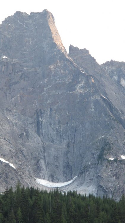
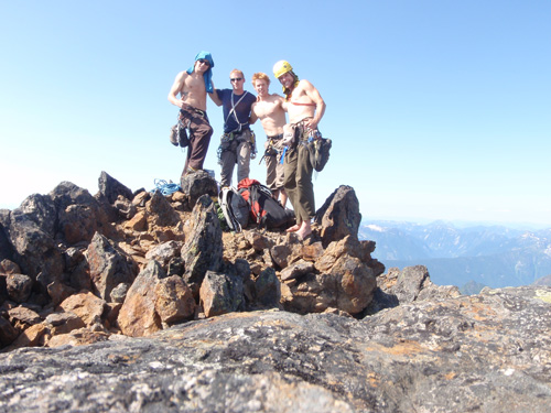
 As for the pitches we climbed on the South side of Grimface, it was only 2 pitches off the "cubby hole" that is described in the Beckey guide. It is on the western aspect of the south face. There is a bunch of stuff that has been climbed in there, but it was difficult to figure out what was what. We climbed the Left facing corner system in the center of the photo. Moving right onto a large ledge below the upper headwall. We climbed the squeeze/offwidth, then branched right through a fingers sections, leading to hands and off-hands. Me branching out in the fingers. This was a fun outing from camp (moderate lichen to deal with). Worthwhile if you want to do something for a couple hours after the hike in. It is an easy scramble to the summit from the top of these pitches. I would grade it at 5.10+.
 -
I understand that there is usually loose rock to navigate... My impression of Faith is there was more than normal. I know you put the route up, but that's just my two cents.
-
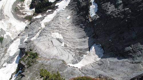
I was in one of the parties that repeated your "Faith" route last August. I just wanted to to say that my experience with the rock on that face seems somewhat contrary to the description above. I found the rock quite loose and, although the climbing was easy, the objective hazard was higher than I had hoped, especially on the lower half of the wall (real risk of pulling stuff down on your belayer). In the topo photo posted just above, you can obviously see that the lower part of the route climbs entirely stacked flakes. The last 60 meters of the route was quite fun crack climbing in more solid rock. I appreciate the new routing!! but I just wanted to make sure people were aware of the loose rock. In my opinion, the whole route deserves and "R" or an "X" because of the objective hazard. We also climbed Sentinel Direct. The rock was way more solid and it was an extremely fun route (one belay on micro-gear), which we then linked into the Grimface traverse (East to West - done unroped except a few raps). We also climbed something on the south side of the Grimface (not sure if it had been climbed before).
-
Beckey = Badass for sure
-
Trip: The Adamants - West Buttress of the Horn, and 2 others Date: 8/1/2014 Trip Report: Climbers: Jan D., Derek C. and Scott B. (myself) Here’s the photo that was the impetus for two separate Adamants trips and a multi-year quest to climb the West Buttress of the Horn. Photo courtesy of the late David Trippett’s 2007 trip report. (http://cascadeclimbers.com/forum/ubbthreads.php?ubb=showflat&Number=712255'>http://cascadeclimbers.com/forum/ubbthreads.php?ubb=showflat&Number=712255) Splitter crack in a remote and wild valley, we were hooked. “It’s like the Bugaboos, but there is nobody there.” On our trip in the summer of August 2014 we made a rare ascent of the Horn along with a scramble up Colossal, a day-long traverse of Adamant, Austerity and Turret and Iron Man, and a separate route up Austerity. I’ve given a fair bit of detail on the Horn as it doesn’t get climbed much and route information would benefit from a bit of enhancement. On the first trip in 2011, myself, Jan, and David flew to the Austerity Glacier and camped below Iron Man. Due to multiple factor (unsure about weather, shorter days in the end of August, groggy after sitting out a 3 day storm and a general feeling “potentially we may be in over our heads”) we didn’t get on the Horn that trip. We were able to climb some other value routes in the area, specifically the Gibson-Rhon and had an amazing trip. Unlike many parties we did not helicopter out, but hiked over the shoulder of Iron Man, down the rather complex Granite Glacier to the Bill Putnam Hut (fairy meadows), then a moderate-severe bushwhack out the Swan Creek “trail.” Almost as soon as we got to the car the sentiment was there, “we need to go back and get on that thing!” It took us a few years, but in 2014 we were back in the heli with a slightly different crew and a different plan. This time we flew directly into the Unicorn Basin below the Horn, leaving a food cash on the Austerity Glacier above. Our #1 priority was to climb the horn. The Horn looks amazing from the basin below. It appears to be an unsupported sharp "horn" of rock that projects into the basin. (1st and 2nd towers of the horn are visible. Photo – Scott B) Colossal Scramble On the 2nd day of marginal weather we scrambled the southwest ridge of Colossal. It was nice to get out of camp and we wanted to scope out the decent from the Colossal-Unicorn col back into the Unicorn Basin. (The tongue of snow that leads into rock in the left foreground is the decent. The Horn is the multi-tiered ridge in the center of the photo. The climbing is much steeper than this photo suggest (especially on the 2nd tower) Photo – Scott B) Decent notes from the Colossal-Unicorn col: walk down the snow and slabs to the apex of the tongue (still walking, not down-climbing). Find large slung boulder with a biner. 2 X 60m raps to the bottom. We had to scramble down ~10m in tall grass to find the 2nd station, which was less bomber, but still serviceable. For anyone how is interested, I want to add a few things to the route description in the Selkirks North (David P. Jones) guide book. So here goes. The Horn TD+ ~600m The description of the approach from a camp on the Austerity Glacier is accurate. We did the approach on the 2011 trip and it was ~ a 3 hour hike from that camp. The ice-fall was fine, but slightly unnerving in the dark. In 2014, our approach from the Unicorn Basin was ~ 30 minutes. We built a tiny plank to cross the shrund from wooden stakes the heli-ski operation leaves in its landing zones. The book describes climbing the left side of a “gash.” The gash is a large prominent chasm seen in the bottom left of the photo below (snow patch visible in it). We found this to be a wet and loose piece of climbing. Head up the left side of the chasm then out onto a ledge after ~ 50 meters of climbing. The exit is the obvious when you’re there as it is the first and only easy place to exit the left side of the chasm. The book talks about a “piton belay at the true toe of the buttress,” which we did not find. (1st tower of the Horn. Peak of the second tower is visible just to the right of the 1st peak. Photo - Derek C.) (In the initial chasm, gearing up to go climb. Climber – Scott. Photo – Derek C) We climbed a full 60m pitch in the “mossy v-grove,” simply staying in the predominant weakness and belaying on a ledge. This section was quite mossy and the protection was sparse, maybe a couple moves of 5.7. (Jan heads up and left from there in the main weakness. Photo – Scott B) From here, the book then talks about “climbing over a steep bulge into a right facing crack.” This was actually face climbing on flakes and cracks, trending up and left to a right-facing corner, which was climbed (5.9 ish), to the “giant block on the ridge prow.” We couldn’t see the giant block from anywhere until you pop onto the ridge prow, then it is obvious. From this point on the description is easy to follow. The book talks about climbing “discontinuous face cracks leading to a steep overhang.” The light colored rock over Jan’s shoulder is actually orange in real life. (Climbing out left around the steep overhang. I believe this is the spot in Trippett’s report where they went right and climbed a 5.11 variation. Climber - Jan, Photo – Scott B) (This is already up the first “stellar face crack” and about to “face climb 3m right” to the 2nd one. It was actually a bit more than 3m I think. The offwidth slot that the book talks about can be seen curving up to the right skyline. Climber - Jan, Belay – Derek. Photo – Scott B) (The second “stellar face crack.” Climber Jan. Photo – Scott B) (Inside the slot, which is actually a perfect squeeze chimney. Good protection in the back. Climber – Scott. Photo – Derek C.) This was the end of the first block of leads at the base of the “right-facing corner.” The book tells you to climb it for 20m then break out left and “belay on a large chockstone.” This section was probably closer to 40m and was sustained 5.10 climbing (awesome pitch). (This is “breaking out left” onto the chockstone belay. Climber – Jan, Photo - Derek C) This placed us below THE PITCH. This was what brought us back. Splitter hands on this hanging face way the hell up in the air. It was awesome. (Sun was coming around the rest of the Adamant group and messing up our picture, but you get the idea!!! Climber – Scott, Photo – Derek C.) (Derek stopped to take a photo of Jan following the splitter. Starting to get some exposure now) The guide book talks about a piton at the top of the crack, then “thin face moves lead in 5m to a bolt.” There were a few bomber placements above the pin, and the face climbing to the bolt was straightforward (5.8-5.9ish). Lots of rope drag when you head left around the corner and onto the north face ledges. (This is the end of the splitter pitch. Super-long slings are clipped to the bolt under the roof. Photo – Derek C) Here the book is pretty accurate. It talks about climbing an “overhanging crack to the second ledge.” I didn’t think the crack was overhanging. It was more of a left-facing corner and the right wall was overhanging and pushing you left. Once on the “second” ledge it was way further around to the left (north) than I anticipated, maybe 20-30m. The ledges are significantly sloping and covered in rock fall debris. Eventually the bolt comes into view and you are able to see how you trend back up and right to the summit of the first tower. The book talks about “belly-flopping” onto a ledge. I just hand-traversed it. A couple balancy moves after. (Jan with the alpine heel hook. On the “belly-flop ledge.” Photo – Derek C) Additional notes on the 1st tower: Significant black lichen. Any of the harder climbing usually required clearing a spot for your foot. The rock was primarily solid, the only loose stuff was in the starting chasm and the debris on the north side ledges when gaining the summit of the first tower. Once you move across the easy, but rubble-strewn ground to the second tower, things become a little less clear again. Now that you are on the north face and away from the ridge crest, the rock changes significantly. It is much more loose until you gain the crest proper again. The guide book talks about climbing “steep cracks for 2 pitches below an overhanging hand crack.” We climbed the main corner (Jan following it in the photo below) and the rock was decomposing significantly. There are a few options here, but I think the best is to go in the main corner, being very careful, and then up a hand-fist crack that continues straight up when the corner jogs slightly to the right. We ran a full 60 m here to a kind of okay stance. (The rock looks good here, but is mostly just stacked broken flakes. We pulled lots of stuff off. Climber – Jan. Photo – Derek C) There is a much better photo of this section on Trippetts cascade climbers report. It’s the 6th photo down. http://cascadeclimbers.com/forum/ubbthreads.php?ubb=showflat&Number=712255 The “overhanging hand crack” above isn’t exactly how I would describe it. The next pitch leads in the same corner system to a big scoop, and you climb out the top of the scoop in the same corner. It is truly overhung here, but it is kind of fingers and stemming (because you are in a corner). Long pitch again, 50-60m. That puts you back on the ridge crest and away from the crappy rock. Two long pitches in total from the base of the second tower to gain the ridge again. (Ridge crest on 2nd tower. Climber – Scott. Photo – Derek C) The book description is straightforward for the remainder of the climb. (Awesome and long Au-cheval sections. Great exposure below. Climber – Jan. Photo – Derek) (This is the “large roof” the book refers to at the end. You can see the ledge system, which you climb around to the right. Climber – Jan. Photo – Derek C) A bunch of easy climbing takes you to the summit! (Left to right. Jan, Derek, Scott) Descent: We made a short traverse over to the summit of Unicorn, and then headed down the north ridge. You can scramble the whole way down in the correct conditions, but we rapped once due to some snow on the slabs. Once at the Colossal-Unicorn col the descent is described above. (North ridge of Unicorn. Climbers - Derek and Jan. Photo – Scott B) There was no summit register that we could find. I believe Trippett’s ascent was the 2nd free and 3rd overall. Ours was potentially the 4th ascent and 3rd free. I’m not totally sure where the 5.11- would be that the 1st free party refers to. There was definitely some hard 5.10. I think our crew would rate it 5.10+. TD+ (you feel pretty out there on it). I am also not sure where the 1st ascent party aided, but maybe at one of the two bolts? We left camp at 5:30am and were back by 6:30pm. Amazing day all in all! Props to the first ascensionists. This was an amazing route and they put it up in 19 hours of climbing. Gear notes: a couple of micro cams just in case, double #1 TCU’s, double .3 camalot to #2 camalot, #3 camalot, #4 camalot. You could go with less but this was a comfortable rack. The rest of the trip We moved our camp up to the Austerity Glacier and camped on the same boulder below Iron Man we had used 3 years before. This trip we also climbed the SW buttress on Austerity, and traversed the entire Adamant group from the south ridge of Adamant to the north side of Iron Man. We had another weather day in there somewhere also. South-west buttress of Austerity 5.7-A1 High quality route! There was old school steep 5.7 on it for sure. Awesome position on solid rock. The A1 section which could be free climbed at 5.11. It would require some lichen removal to truly give it a go. Also memorable on this climb was a paper-thin flake that you grab and mantle onto. Not to be missed☺ The Adamant group traverse 5.8ish This is “truly one of the finest lines in all the Selkirks.” Simply an amazing skyline traverse. Climbing up to about 5.8. Tagged the summits of Adamant, the Turret, Austerity, and Iron Man. Highlights were a bluebird day in a stunning setting, views of Sir Sandford, and the summit register from Adamant. An entry from 2003 showed Fred Becky and Colin Haley had climbed the SW rib of Adamant. Beckey was 80 years old at the time! (Photo – Derek C) (The adamant group. Photo – Jan D) General notes on the Adamants There is so much rock to climb in the area it is amazing. The most recent summit register entry was from 2011, the same year we had been there previously. There may have been a party or two in the mean time, but our bivy boulder looked the same as we left it and there were no new registry entries. I’m just saying, maybe 1 party a year. That is pretty awesome! Hike We hiked out the same way we had previously, over the shoulder of Iron Man and out. The hike is not trivial and takes two days, but we thought it adds value to the trip. Our other goals on the trip were to traverse the entire Blackfrier group, climb the south face of Iron Man and climb Supersickle on the Stickle. Alas, we ran out of time but had another amazing trip!
-
best of cc.com [TR] Bugaboos - Many 8/15/2010
CrackMeister posted a topic in British Columbia/Canada
Trip: Bugaboos - Many Date: 8/15/2010 Trip Report: Bugaboos trip Aug 15th - Aug 22nd Dave and I awoke dizzy and blurry eyed on the Sunshine Coast after a friends wedding. The night before we vowed to be on the 0815 ferry back to Vancouver. We ended up on the 1300 ferry and feeling severely hung over. Not the alpine start we wanted for our Bugaboo trip… After shopping, eating, and driving to the gravel access road, we finally set up the tent and passed out at 0130. An early rise had us hiking by 0700. Two hours and 15 minutes later we were dropping gear in Applebee and heading up the Snowpatch/Bugaboo col. It was only about 1pm by the time were walking behind Snowpatch spire. Our original plan was to go solo the west ridge of Pigeon, then bivy the night and do the Beckey-Chouinard the next day. Instead we did Wildflowers, 5.9, on the back of Snowpatch. By the time we were setting out bivy gear beside Pigeon it was later than expected and we were really feeling the lack of sleep of the previous days. Our prospects did not look good for the B-C… Wildflowers [img:center]http://i758.photobucket.com/albums/xx222/Scott_Burrell/IMG_4261.jpg[/img] After a cold and windy bivy the alarm finally went off at 0330. The conversation went, How do you feel? Not good... Me neither... We should probably just suck it up and go anyway. Shit… After the decision was made it became much easier. 4th class scrambling at the start of the Beckey-Chouinard [img:center]http://i758.photobucket.com/albums/xx222/Scott_Burrell/IMG_4321.jpg[/img] Scott following low crux on Beckey-Choinard [img:center]http://i758.photobucket.com/albums/xx222/Scott_Burrell/IMG_4339.jpg[/img] The B-C lived up to all the hype. Pretty much 1000 meters of 5.8-5.9 hand cracks. We were on the summit by 1320. Raps took about 1.5 hours with double ropes. If you have the energy, I would highly recommend the 5.10 finger/hand crack variation around the squeeze chimney. It was probably the best pitch of climbing on the whole route and that chimney looks ugly. Dave following 5.10 variation on Beckey-Chouinard. Squeeze chimney visible on left of pic. [img:center]http://i758.photobucket.com/albums/xx222/Scott_Burrell/P8170024.jpg[/img] Our only difficulty came on pitch 15 (Chris Atkinson and Marc Piche guide book), the tension traverse or 5.10 + variation. The problem was we somehow missed this pitch… The confusion started as Dave lead pitch 13. The book reads, “Climb the gully over chockstones to where it steepens into a capped corner. Climb the second crack on the left wall to belay at the base of a long, shallow, right facing corner (5.9 60m) 14: Follow the corner to a two-pin belay at a small notch (5.8 30m).” This is then supposed to be the tension point, then a 5.6 gully to the top. Dave takes off and I notice that he is at about 55m, I shout this information at him, but probably due to wind he doesn’t hear it. I interpret this as he is ignoring me. The rope goes tight and I start simul-climbing. Once I can see what’s happening I can see the capped corner referred to in the book and the cracks up the left wall. Dave is way up on the left arête of the gully having climbed what appears to be the second crack on the left. I followed up the left wall, which was 5.9-5.9+ train track hand cracks, awesome. He builds a belay at the base of a long shallow right facing corner. Seems like we have followed the book perfectly but appear to now be in a 5.6 gully that goes to the horizon and we have not seen a pin or small notch anywhere. I jump on lead and take us to the top, which was in fact the correct summit with a 20m rap and then 4th class to the true summit. In hind sight you are supposed to go all the way to the capped corner than climb the crack 2nd to the left FROM THE CORNER. So really we turned two pitches of a chockstone filled gully, a weird 5.8, and tension traverse, into an 80 m pitch of solid continuous 5.9 hand crack. We thought we should pass this information on to the original assentionist. The letter is as follows. [font:Times New Roman]Dear Mr. Fred Beckey and Mr. Yvon Chouinard: My friend Dave and I recently climbed your world famous route up the SW Buttress on South-Howser tower. I can see why it is such a sought after climb, wow, what a route! Amazingly sustained at its grade and the line is stunning. We noticed that between pitch 13 and 15 the quality is slightly less than average, and many people require a tacky tension traverse. We would like to let you know that we have now fixed your route to follow the ethics with which it was originally intended by trading aid for crack climbing. We have posted the necessary changes in a popular climbing forum. Scott and Dave [/font] All kidding aside, it really was a simple mistake that I am sure many have made before us… Oops. I hope all our route finding problems end up this well. The next day we woke up late and did Surfs Up, 5.9. Dave got off route and in all fairness I think most parties that climb that route go astray somewhere (this must have something to do with the guide book describing “follow the corner” when about 10 corners exist in close proximity). This time we weren’t lucky as on the B-C. I lead through a 5.10 + roof with bottoming fingers, then we had to rap over to the proper dihedral. Dave finished the route up following amazing hand cracks with awesome exposure. Scott following up high on Surfs Up [img:center]http://i758.photobucket.com/albums/xx222/Scott_Burrell/IMG_4481.jpg[/img] [img:center]http://i758.photobucket.com/albums/xx222/Scott_Burrell/IMG_4491.jpg[/img] The following day we did the Cooper-Kor on Pigeon spire 5.9, A0. This route was really amazing mostly because of it’s positioning on the wall. Dave and I also really like the alpine feel of the tension traverses way up on the exposed wall. We haven’t done too much of that stuff so it was neat to run across that wall. The slabs and one 5.9 finger crack were quite wet, making it a bit tricky. Dave following the slab pitch [img:center]http://i758.photobucket.com/albums/xx222/Scott_Burrell/P8190096.jpg[/img] The weather started to move in that evening. So the next day we went to Crescent Spire and climbed Paddle Flake Direct 5.10. Again, more amazing crack climbing that was surprisingly steep. We then climbed the 5.10+ roof McTech after as a single pitch. Good way to finish a short day. Scott leading roof McTech [img:center]http://i758.photobucket.com/albums/xx222/Scott_Burrell/IMG_4613.jpg[/img] The weather was really not looking so good for the next day so we went off to climb Sunshine Crack 5.11- on Snowpatch. It is a good one to climb in unsettled weather because it has bolted rap stations down the entire route. The low 5.10 off width is a bit of a bar fight, but very doable, just a lot of grunting… This route continues with amazing jamming pretty much the entire way, passing through 4 roofs. The 5.11- roof is only about 1 move and is softer than the grade implies. Two pitches from the top it started to snow while Dave was leading. Shit. By the time I was brought up to his belay stance it was a full on blizzard. Encouraged by the sound of another party’s cheers after pulling through a roof below us, I tied into the sharp end and took the rack. Half way up this long pitch, and fairly run out, Dave yells up “Scott! Check it out, there is significant snow accumulating on the ropes.” Thanks Dave, that’s very helpful at this point… Arriving safely at the top and bring Dave up, we snapped a couple pics and rapped out. The raps went better than expected considering the ropes were being blow horizontally below the rappeller. Scott leading 5.10 offwidth on Sunshine [img:center]http://i758.photobucket.com/albums/xx222/Scott_Burrell/IMG_4622.jpg[/img] Gearing for final 5.10 pitch on sunshine (in the snow) [img:center]http://i758.photobucket.com/albums/xx222/Scott_Burrell/IMG_4644.jpg[/img] We rolled into camp, grabbed out gear and ran out to the car. We were back in Vancouver by 0245 in the AM. Gear notes for Sunshine: Take doubles to and including #4 camalot, and one #5 camalot. You can push the # 5 up once or twice and then the angle of the crack backs off. You can leave the #5 clipped to the anchor at the top of pitch 2 (the off width) because it isn’t needed after that. The double #3’s and #4’s are nice for the top pitch. Sunshine was by far the best climbing of the whole trip. That route is amazing. Gear notes for the Beckey-Choiunard: We took doubles up to and including #3 camalots, and one #4 camalot, and a 3rd # 2 camalot. You could definitely do it without the triple #2’s, but we simul-climbed a lot of it and it was nice to have extra of this very common size on the route. You can also make an argument to leave the #4. It was placed but we did not climb the chimney so it wasn’t “necessary,” depending on your comfort level. Crazy awesome trip! -
[TR] Tantalus Range - East Ridge of Alpha 7/24/2010
CrackMeister replied to david c's topic in British Columbia/Canada
Nice T.R. I like the classic summit pic. -
That's very helpful. Thanks for your input.
-
I think there is a solid 15-20 meters of 8 inch squeeze chimney so I would prefer to have some pro...
-
I am living in Vancouver and have had my eye on Squamish's classic Pipeline, an 8 inch overhung off-width. Does anybody have a Valley Giant #9 laying around they would be willing to part with for a reasonable price. I could go with big bros, but I like the giant cam idea better. Thanks for any help!!
-
[TR] Mt. Slesse - Northeast Buttress 7/10/2009
CrackMeister replied to CrackMeister's topic in Rock Climbing Forum
I added some pics as attachments to the TR. Hope that helps -
[TR] Mt. Slesse - Northeast Buttress 7/10/2009
CrackMeister replied to CrackMeister's topic in Rock Climbing Forum
I have a bunch of pics to add but I am not sure how to get them into the trip report. Anyone know?? -
Trip: Mt. Slesse - Northeast Buttress Date: 7/10/2009 Trip Report: After a years worth of talking about climbing Slesse’s Northeast buttress, it was finally going to happen. The plan was to pick up two friends who would climb as a pair (both red heads, we affectionately called team ‘ginger balls’) at the ferry and then meet with Dave (my partner) in Chilliwack. Some classic Friday afternoon highway traffic slowed our progress but before too long we were wolfing down some pizza looking out at the mountain. While stopped, Dave astutely noticed a small black truck with a few people sporting they’re dreads, body hair and a bunch of climbing gear. All of a sudden concerned that a hideous El Cap.esque parade of fellow climbers could taint our early season ascent, I wandered over to hopefully discover they were from out of town and headed to Squamish… Not only did I discover that they were headed for the Northeast buttress and they had the same wooded knoll bivy plan, but they were NICE! Dam, I was bound and determined to hate them too… I should point out that 3 of the 4 of us are river kayakers, turned climbers in the past few years. So we are trying hard to play the part of ‘climbers’. While a kayaker would be stoked to meet another crew on a river, we’ve learned that climbers get pissed off and threatened by another crew on their climb. Hence the attempt to get our hate on. The trip initially felt somewhat tainted by Officer Farva (seen Supertroopers?), a police officer who pulled us over on the Chilliwack River road. Apparently, we fill the profile of “Rave going partiers who will stab each other and leave our body parts strewn around the valley for others to pick us up”. So Officer Farva poured our case of Lucky (beer) and complimented himself for “saving these guys from consuming that crap”. Thanks chief. The dropping of the shuttle car went well. There were no road finding problems and we were “lucky” enough to find a hidden key for the locked gate at the entrance to the road. Leaving a car as far as we could, we set off for the Northeast side of Slesse, noting the other party had deposited their truck on the outside of the lower gate. Haha, they were not “lucky” enough to find the hidden key! We got up to the approach right as the other party was headed up to the wooded knoll. With some polite conversation we agreed to see them up there. At 9pm after an hour of food/gear prep we were on out way. Our party was walking into virgin territory so walking by the Slesse Memorial sight at sun down was a moving and humbling sight. The glacial circ and the sweeping buttress itself filled us with excitement and a little nervousness too. The night was warm and clear up on the wooded knoll. With a bed made of ropes, backpacks, one thermorest, and spruce bows we were sleeping by 11pm. The alarm went off at 3:30 am, and after some food and some water we headed off through intermittent snow patches to try and find the small trail across to the bypass glacier. In the darkness we missed the trail somewhere and ended up at the propeller cairn. After a quick assessment of the Slesse glacier, we decided that it was not totally safe, but safe enough that we were willing to gamble at 4am. I took the lead and stated running across hard snow and a couple slabs for a little notch in the East Pillar. Approximately 5-10 minutes later I was standing safely below the notch, very sweaty and panting like a dog in heat. Dave, bringing up the rear, had just begun the sprint across so I waited. Shortly after we were all standing on the other side of the notch, one glacier crossing down, one to go... The bypass glacier, which was our main safety concern on the trip, had mostly slid away. The portion that remained was about 20 meters from front to back and 80 meters left to right. The problem was that a portion was sitting entirely on the 3rd class ledge making that route too dangerous for our liking. Having heard thunderous ice fall through the night we quickly made a plan B. It appeared that near the edge of the lower circ there were some low 5th grade corners that would make it possible to gain the Direct start without traversing back down. We felt safe enough to roll the dice again and set off for the second 5 minute long death dash. I am not one to really dwell on the possibility of a disaster, but in this case I found myself making endless evasive maneuver plans, and despite burning legs in the middle refused to slow down. The traverse was a little trickier than the previous one with some steeper slabs near the end, but we all made it safely across. As a team we vowed to finish the climb no matter what just so we did not have to cross that again. By 6am the sun had hit the bypass glacier and chunks started peel off below us… sketchy! Some fun low 5th soloing found us on the direct start about 2 pitches from up the bottom. We continued to solo with only one 20 meter wet/mossy section requiring a rope. We were having a lot of fun climbing the less traveled route but we were excited to get above to where the real climbing started. Above the 3rd class bypass ledge we saw the party behind us making the death sprint for a similar spot lower on the toe. They obviously made the same safety assessment we did and wanted nothing to do with the bypass ledge route. From here we simul-climbed for a while up amazing 5.7 splitters and dihedrals, eventually reaching the crux 5.10 pitch. As I had lead for all of the solo route finding and simul-climbing pitches, Dave jumped at the chance to lead the intimidating looking broken roofs. A steady pace and a short time later, he was hooping and hollering at the top. The climbing felt very juggy through that section and with weird but solid pro. A couple more lead swaps and we were stretching out on the main bivy ledge at 9am. The exposure looking over the east side of the buttress is pretty amazing and above the head wall looks far to steep to be the 5.7ish grade claimed by Alpine Select. We were especially pumped to find a big pile of snow to fill the water bottles. While sitting on the ledge, Dave and I decided that this was definitely the highest cliff we’d ever dangled our feet off of. Shortly after, the intrepid team ginger popped onto the bivy sight. The party of five behind us was up the improvised corners and on the buttress proper, but not going very fast. We hoped that the large packs we had seen include bivy gear… Anxious to get moving we put the shoes back on and started scrambling the 3rd, 4th, and low 5th terrain above. A substantial amount of snow remained in this area and there were a couple tense moments on slippery moss, but we all arrived at a good-sized ledge where we dawned the ropes again to pitch out the final head wall. The climbing was a bit nebulous on well feature rock. At this point Dave and I had chosen a groove next to the crest of the ridge which proved a harder than it looked. Team Ginger Balls decided to try about 5 meters to the right without any better luck. Just a weird pitch I guess. The final “crux” rated at 5.9 was met with more shouts of joy from my excited partner. The thin tall flakes and many stemming possibilities made it a great pitch. Not knowing exactly how far until the top we kept the lead swapping going at a brisk pace. The final 5.7 pitches are so exposed that when you grab the crest and peak down you inadvertently let out a giggle. Not a normal one, but the one were you feel like you’re getting away with something that you shouldn’t. I crested over a short steep corner to a bench that was clearly the last before the summit. As I had not placed any gear yet, I selected the 3 meter tall free standing pillar in the center of the ledge and plugged a cam up high on it. One last set of bounding moves and I was on the summit!! As all the rock is decaying I sat myself behind a boulder, braced my feet and called for Dave to follow. When I thought he had just about reached the only cam on the pitch, I was rewarding with a round of laughter, bringing a smile to my face. Team Ginger Balls was hot on our heals so we did not have much time to prepare, luckily just enough though. Bob, being the final person to the crest, was greeted by nude Dave and I bent over in a pose affectionately called “the goat.” This involves all the bits being placed between you legs as you are bent over in the moon position. The view from behind is a sight that will make most people cringe! Bob’s facial expression was incredible as the expression of elation and relief was met by discussed. Man, there is nothing like a great burn on your buddy at the top of a massive climb. Peering back over the climb we noticed that the party of five behind us was only as high as the bypass route connection and appeared to be stopped. We hoped that nobody had been hurt, but as we were currently in no position to help we resolved to worry about getting our party off. Now at 4pm we thought the climb had been a blazing success. A little relaxing and some summit photos, including a blue bird view of the surrounding mountains and Baker was a rich reward for our effort. Being that we all knew that we were only half way done the climb, we headed off down the west face decent. The rappels and down climbing went without incident except a 5 minute rope snag. The hiking train down is an amazingly steep but well worn and in the upper sections, easy to follow. We descended to an alpine meadow that is the beginning of a massively steep drop down to the Slesse Creek valley floor. Near the top of this we lost the trail and began to search for it. I searched right and the others searched down and left, neither having any success. The book description about this portion of the trail is brief but describes the trail as following the crest of the ridge down steeply. I strongly voted that we bite the bullet and hike back up to where we last had the trail, half an hour to an hours walk. Everyone was getting pretty tired by this point and I was swayed to continue down, bushwhacking and searching for the trail. At approximately 9pm it was getting dark in the thick trees and no sign of the trail was to be found. Our water supply and energy levels indicated that it was time to be down with this silliness and back at the car. We had some further trouble with steep scree slopes and scary cliffed out sections, but continued to make progress down. As it finally got dark I was unnaturally excited by grabbing a devil’s club with my bare hand. This meant two things, I needed to dig out my headlamp, and we were getting close to the valley floor. Our spirits were lifted for a short time before being dampened again by a pesky 2nd growth forest. The combination of tiny bushy trees being less that shoulder width apart and the forced use of a head lamp, gave the effect of being in a blizzard with high beams on. We were brought almost to hands and knees, but desperate for water we pushed on. Ahead I saw some open light, which previously meant a cliff, so I warned everyone, and proceeded to the edge to look. I found myself at the top of a 10-15 meter steep sand/dirt bank. As I was about to say everyone should head left and around it, the tree I was standing on broke and I skidded, slid all the way to the bottom. Sweat from head to toe and then the unplanned roll in the dirt made me look like some sort of primitive monster, but despite my current state, I was overjoyed to be standing on an old logging road! My shouts were met with equal shouts from everyone else. Time was a bit lost to us but we eventually found a creek and drank deeply. Secure in the fact that is we could safely bivy with water to drink. We continued on with lots of discussion and betting of beer as to where we were and if we would come out at the car. By 11pm we stumbled around the corner to the best site I have ever seen, the car! Also present were two mountain bikes, indicating the presence of another party on the mountain. We drank some gatoraid that was stored in the creek and took off to go retrieve the other vehicle. Arriving at the locked gate I hopped out to go open it only to discover the hidden key was missing. F#ck, s!#t, mother f#cker. After a search of the rocks and the other vehicles in the pull out, we admitted defeat, set up a tent and I don’t even remember laying down before falling asleep. Five minutes later (I was told the next morning) a thunder and lightning storm hit the week long forecast of blue skies. I’m glad we were not still on the wall! The next morning we woke to find the truck from the party of five missing. That was a great relief because they had successfully reversed off the climb and were able to get out in the night while we were sleeping. Hitching a ride to the upper car with some people headed to Rexford Dave was able to get the top car back relatively early. I had sore/blistered feet and stayed in the car sleeping... Team Ginger Balls had hitch hiked the other way to make some phone calls and by 1pm the stranded car was on the correct side of the gate. As we were preparing to head back to the city the two with bikes arrive at their vehicle. They were attempting to climb the west face, but during the night the storm had rolled in. We learned that they were bivied just off the top of our alpine meadow and heard us crashing off route through the trees. They tried to signal us with whistle blasts but we missed their hails. Oh well, at least they got some good karma out of the deal. The climb was amazing and definitely my biggest one day undertaking yet. The minor epic at the end was a good lesson. What you are not prepared for can really mess you up. But it all worked out well in the end. I figure it’s like getting Clamydia. If you are going to get an STD at least that one is treatable… Gear Notes: 1 set of nuts 1 blue TCU 1 yellow TCU 0.4-3 camalots (double .5, .75, 1) I would leave the #3 and one of the double camalots next time because there is a huge varied of placements everywhere Approach Notes: 1.5 hours to wooded knoll at a quick pace. Bypass glacier is sketchville.
-
THANX man! That helps a lot. We will be quick across the slabs...
-
Does anyone know if the infamous pocket glacier is still in place? If so, what shape is it in? I am looking to sneek by next weekend... Thanks for any info!

