


alpenho
-
Posts
25 -
Joined
-
Last visited
Everything posted by alpenho
-
[TR] Maximum Impact Climbing - 8/28/2010
alpenho replied to tvashtarkatena's topic in North Cascades
then there's this story from MT, which didn't work out so well for the trundler's in question: September 25, 1994, a Butte climber named Tony Rich was killed not far from where Earnest Bruffey landed decades earlier. Rich died under a cascade of huge boulders while ascending Granite Peak by way of the snow-covered north face. His climbing partner, Fred Donich of Ennis, said that the two frantically tried to dig themselves into the snow in hopes that the rocks might skid over them. But Rich’s helmeted head was crushed by a truck-sized boulder that rolled down from the summit above. An investigation followed, and ultimately three young climbers who were on the peak above Rich and Donich were charged with negligent endangerment relating to the incident. Evidence indicated the threesome had pushed tons of rocks and debris off the summit without knowing there were climbers below. Each defendant ultimately pled guilty to misdemeanor charges. -
[TR] Mt. Triumph (bailed, stormed out) - 7/22/2010
alpenho replied to cascadesdj's topic in North Cascades
Sorry to hear about missing the weather, its a great climb. Myself and 2 buddies just got back from doing the NE Ridge in perfect (maybe too hot) conditions. Of note: Probably the best bivy site is that knoll at the bottom of your last pic - Much wider views and liquid water can be had by digging at the edge of the snow to make a little puddle. The snow crossing is great, but getting soft in spots. There are a lot of stressed areas in the snowpack where gliding is pulling it apart. One of the guys in our group took a plunge to the hip, so gotta watch the weaknesses in the snow. Nice snow ramp leading to the ledge to the base of the climb so no real sketchyness to get to the start, but no good place to bivy until your at the top of the first step. With 3 on one rope we were pretty slow and were doing about half the descent after sundown. We also went back around to Triumph Pass to make a go for Despair but got weathered out. The approach to the pass is rugged. Ample evidence of a very large bear with cubs inhabiting the vicinity of the pass. Good luck if you have another go at it! -
Our plan is to get to the Mystery Ridge traverse via Triumph and Despair. We really want to do the NE ridge climb on Triumph, and if possible take skis for the rest of the traverse, taking advantage of the outstanding snowpack up high. My thinking is that carrying skis over the summit might be slightly ridiculous (or would it?), so instead we would ascend and descend the NE ridge, then drop into the north cirque to traverse over to Triumph pass vicinity and on to Despair. I can't find a lot of info about dropping from the base of the NE ridge into the north cirque, so I don't know if that would be feasible or sane.
-
Anyone have info and/or recent photos of the North Face/cirque of Mt Triumph? Particularly interested if it is possible to descent from the col at the base of the NE Ridge and continue to Mt. Despair from there. Much appreciated!
-
Trip: Shuksan Circumnav - White Salmon Date: 5/1/2009 Trip Report: We had some incredible weather on day one (Friday 5/1) and for the first half of day 2. We started from the White Salmon Lodge at about 4am under clear skies. The skiing sucked to put it mildly. Wind and sun baked crust or mush, not much in between. From Mt. Baker Ski area the descending traverse to the bottom of White Salmon cirque is on its last legs - gullies are getting steep and deep, and not in a good way. Lots of huge frozen avy debris filling the bottom of the cirque, and we kept ski crampons on the whole time we climbed. Some sections necessitated boot packing, notably at the toe of the White Salmon and the transition from White Salmon to Upper Curtis. Hells Highway was skin-able the whole way. Summit Gully was filled in all the way to the top, and we managed to ski descend it from a side entrance about 30 ft from the summit. Camped on the edge of the Crystal, right where the easterly winds were the strongest. Fortunately the breakdown of the high pressure ridge happened as forecast and it was dead still from the middle of the night through the next day. We crossed the Crystal, checked out the Nooksack Glacier, then headed over to the upper Hanging Glacier for a very chattery icy traverse over to the Upper Curtis where the snow became barely perceptibly softer. The skies were growing ominous and we decided to get the hell out of dodge. It was at this point that we encounted some "firm corn" and definitely the best skiing of the trip. As we approached the bottom of the White Salmon glacier, we stupidly decided that it would be cool to do a high traverse over to the Shuksan Arm and ski along the top of the ridge, coming out at the top of the ski area. The non-fun aspects of this decision are shamefully too numerous for me to describe. All in all, it was a great weekend adventure outing despite the snow conditions, and a cool tour of some amazing high alpine glaciated terrain. Summit Pyramid from our camp at the Sulphide/Crystal divide: On the final section approaching the summit. Our ski entrance is to the lookers left of that guy in the photo: Ski descent down the summit gully: Camp at sunset: http://www.youtube.com/watch?v=FIcOceGjPn4 Approach Notes: We saw a huge icefall avalanche come off the Hanging Glacier when we were high on the White Salmon, right about the time the sun just started hitting the upper mountain. Start early...
-
best of cc.com Random Climbing Partner(s) Stories
alpenho replied to wfinley's topic in Climber's Board
These are some great stories and gives me some perspective on what a messed up trip really is. I've been lucky in having relatively sane climbing partners so far... -
Trip: Coleman Pinnacle - West Ridge Date: 11/16/2008 Trip Report: Started from Heather Meadows, walked clear road until about 100 ft beyond Lake Ann TH, whereupon we were able to skin to Artist point. Beyond Artist point, a few short carries and/or creative skinning all the way out along Ptarmigan ridge. Snow was soft slush on top of a hard consolidated layer, so sidehilling resulted in some slippage, but I think we have laid down a good track. Skinned up to the W Ridge of Coleman, ditched the skis, and scrambled to the top, slightly tricky with ski boots, encountering intermittent snow drifts but mostly dry rock and vegetation. Coleman Pinnacle (foreground) from the east: We dropped to the saddle with the intent to ascend the West subsidiary summit and ski off the north side, but when we got there encountered bulletproof ice. So we had some lunch, and dropped down along a big snowdrift on the southeast side. It was great soft corn. Our route up in green, down in red: we skied down to the snow feature informally known as "goat throat", dropped down to the bottom and skinned back up and out just as it got dark. Lot of melt during the day but the ski out was essentially the same as in.
-
Trip: McClellan Butte - South Ridge Date: 11/15/2008 Trip Report: Not too notable as a summer climb, but there haven't been a lot of recent TRs in this forum, and I think I have a French Bulldog First Ascent. On the summit: Approach Notes: trail is muddy but clear of debris. Very little snow.
-
That's awesome - I've wondered about some of my climbs with my French Bulldogs, they've been up several summits in the Cascades and I've never seen any others out there. Here's one of em on the top of Yellow Aster Butte:
-
Trip: Vesper Pk. - E Face and Vesper Glacier Date: 8/23/2008 Trip Report: for anyone that doesn't lurk on the TAY site year round and interested in some August snow, here's a TR for Vesper Peak by yours truly. Gear Notes: you do not need plastic mountaineering boots, crampons, or an ice axe for this climb in August!
-
Nice! Such an incredible area - Gannett is next on my list for the Winds. Great idea with the raft too!
-
[TR] Isolation Traverse, Pyramid to Eldorado, Aug. 1-7 - 8/8/2008
alpenho replied to alpenho's topic in North Cascades
That would be an honor, thanks! Also, forgot to mention this, but I came across some twisted metal on the north side of Newhalem Pk that looked like it came off of an aircraft, with some black and orange paint. Just curious if that was part of a known wreck or something. Couldn't find anything else that looked man-made, just this piece of metal about 10" X 12". -
just sitting right on the very top. Let me know if they are yours.
-
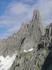
Trip: Isolation Traverse, Pyramid to Eldorado, Aug. 1-7 - Date: 8/8/2008 Trip Report: Colonial Pk Pyramid Pk Paul Bunyan’s Stump Snowfield Pk The Coccyx Early Morning Spire Eldorado Pk The Isolation Traverse – maybe a classic of North Cascade mountaineering of olde. This had big trees, meadows, glaciers, rock both solid and crumbly, and brushy cliff bands that can make you cry. Even the weather cooperated to give us just about everything the Pacific Northwest can dish out on any give summer week. My apologies for the extended length of this report, there is a lot to tell… Four of us started out early on 8/1/08 from Seattle, parked one car at the Eldorado trailhead on Cascade River Rd. and then proceeded to the Pyramid Lk. trail and started going up. The route past the lake was your typical “climber’s trail” – a thin muddy route straight up to the ridge. At the ridge it was up and down, with the route becoming ambiguous at a few points at vegetated steps on the ridge. Just after treeline the route dropped left off the ridge and up talus and snow to the rock barrier at the foot of Colonial Glacier/Lake. Both the clouds and the temps were dropping and as we got our camp set up at a tarn some harsh wind and rain was bearing down. We were lashed by the weather all night although this did not deter the rodents from chewing into a food bag. 8/2 – at wake up time rain and wind still so we hung out until things started looking a little better and we made a quick dash for Colonial with the intent to get back, pack up camp and move up to the Neve Glacier. The weather had different plans and as we returned to camp the wind and rain was back to continue its punishment. We went to bed with the thought of bailing if the weather wasn’t better by noon the next day. 8/3 – wake up time finally saw blue skies so we packed up camp and got onto the Colonial Glacier. We ascended about halfway up, dropped our full packs and headed up along snow ramps to Pyramid Pk, then a traverse down to a rock island where M. and J. waited it out while K. and I quickly made our way up to Paul Bunyan’s Stump, starting on the South ridge and climbing up class 4 slabs around the West face to the North ridge in a “Corkscrew” ascent to the summit. Our route shown in red below, as viewed from the Colonial-Neve Glacier Col: As we all met up again down on the flat, M. and J. citing difficulties of psychological fortitude announced they were bailing. We discussed options and decided to head up to the Colonial-Neve Glacier Col to see what was in store. On the way up I had to come to a difficult decision that I would proceed with the trip as planned – too much juggling of work and marital issues had occurred for me to simply give this up so easily, and besides this was part of my “just got my PhD” celebration, come on!! I put it to the group, saying I would love it if any and all wanted to join and K. decided to stick with it. Ok, enough stuff about personal drama… So the group split at the col, with K. and I continuing across the Neve to the col between Snowfield Pk. and the Horseman – this was very straightforward. We dropped down a little way, stowed our full packs and then headed up Snowfield via a class 3/4 route going up the SW face, ascending the W ridge for a ways, crossing to the north to parallel the W Arete, through a notch crossing back to a south-facing gully and up to the summit. At the top I found a pair of sunglasses! Looking north across the Neve: We dropped back down to get our packs, then made a descending traverse toward the SW ridge. This turned out to be a mistake. We should have either made a rising traverse (toward the E/SE) to cross the ridge into a south-facing bowl or followed snow fields down (toward the W) to cross under cliff bands to reach a flat area at the bottom of the ridge to camp. We descended the ridge crest and at a 5th class short downclimb at a step K. took a fall, but he was mostly ok once we got to camp and made a significant dent in our whisky stash. The camp here had incredible views all around, and we decided that this was one of the coolest camp sites we’d seen in the North Cascades. 8/4 – we awoke again to great weather but knowing we had a possibly difficult day ahead as we entered the “maze” part of the trip. We were able to get a pretty good view of Isolation Pk. and a probable route that roughly corresponded with the info we had, so we took off along the ridge and then descended toward the lake we called “Isolation Lake”, then climbed a snow ramp to a shoulder on the E side of the mountain. The shoulder continued as a nice bench (even potential campsites here) around to the S/SE face of the mountain where it ended in a talus field. This is where things got exciting as we determined we should just plunge down through alternating brush and steep heather, working around rock buttresses toward the south ridge leading to Wilcox Lakes. An apt description of the nature of this traverse would be 4th class mixed rock and tree; veggie belays were heavily utilized. However to keep things in perspective this part took us just under 1.5 hours. Following this, the flat area around Wilcox Lakes was another spectacular alpine area dotted with meadows, rock outcroppings and tarns. A series of shallow tarns that looked almost tiled with flat rocks was too enticing so we had to take a stop to jump in and hang out here for a while. This was a great way to get our spirits soaring in preparation to get knocked down again. We thought we had our route figured out and headed straight up to a col just to the E of Newhalem Pk. When we got there the other side seemed to drop straight down in to a deep hole with a pretty improbable climb out on the other side (I could be wrong on this – Lowell Skoog’s description of this traverse as a ski tour shows the route going through this cirque – maybe more feasible with snow coverage?). The north end of Backbone Ridge was tantalizingly close, and the ridge on the W side of the cirque seemed to look like a go, but we thought we had to climb up to get there, as the topo map seemed to indicate friendlier territory above. We topped out on a subsidiary summit of Newhalem Pk. with a deep gorge separating us from the SE face we intended to traverse. There was no way this route would work. We sat down to check things out and decided that the best way would be to drop back down where we came from on the N side of Newhalem Pk. then skirt around the W side of the mountain to get to Stout Lk, which seemed to be a favored basis for many of Beckey’s route descriptions for climbs in the area. So we downclimbed back into the Wilcox Lakes basin and then ascended to a flat area on a ridge coming off the north side of Newhalem Pk. where we made camp. Backtracking off such hard-earned territory was mentally tough and we directed our frustration at the subsidiary summit we climbed, deciding that in keeping with anatomical nomenclature of the area we would call it “The Scrotum”. 8/5 – Fortunately the good weather was holding, because we started this day expecting another tough go. It didn’t start off well – getting off the ridge into the next bowl was more bushwhacking through cliff bands. K. found a good way through by going down the ridge (north) through trees to a grassy/shrubby SW-facing ramp. My descent was an ugly and fast slide down some moss-covered cliffs which miraculously only cost me half of the fingernail on my left pinky finger. We crossed a talus bowl and then ascended up a gully to a shoulder on the W side of Newhalem Pk. We were now looking straight down at Stout Lk. The following photo shows our route around Isolation and Newhalem Pks. looking south from the Snowfield-Horseman Col (The nasty part of the descent to Camp 2 is off the photo to the left): From the W shoulder of Newhalem the descent to Stout Lake was straight down, mostly steep heather working around small cliff bands and some shwacking to the only flat and clear area around the outlet of the lake. There is fisherman’s camp here with cached campfire grills and frying pans, and it looked like tons of trout in the lake. Now we headed up the ridge due south of the lake outlet into a furious steep uphill brute-force bushwhack that was fortunately the last one of the trip. We ascended to the W shoulder of the unnamed peak SE of Stout Lk, then climbed about 500 ft along the meadowy ridgeline until we came to an open area leading to the slabs of the next cirque below The Coccyx. The following photo looking down at Stout Lake shows our route to the ridge: And the route through the cirque below The Coccyx and the entrance to Backbone Ridge: We dropped our packs at the Coccyx Glacier and ascended up the snow to reach the W ridge. We took the rope and 2 pickets for a single pitch at the cornice going over what appeared to be a sagging bridge over the bergschrund at the headwall. The rest of the way to the summit was a class 3 scramble up talus and blocks. The following photo is looking back at the snow headwall and beginning of the rock ridge: After dropping back down to our packs we made a slightly descending traverse to the point where the ridge flattens out for an easy drop into Marble Creek Cirque. This area was beautiful knolls, rock slabs and streams. Fortunately we had a lot of snow for easy travel – in later season or with less snow it looks like there are some gorge-like features that would need to be negotiated. We made it almost to the end of the cirque where it meets the Marble Glacier. 8/6 – Another great weather day – we made a rising traverse from camp to the ridgeline at the south end of Backbone Ridge, then onto the Marble Glacier. We weren’t sure exactly where to cross over to the McAllister, and made an exploratory venture to a col that turned out to be much too far north. We decided to just head to the high point of the glacier and if nothing else we could climb Early Morning Spire. Access to the E ridge was a little tricky, involving a short climb into a moat then up a messy dihedral to a rap sling that we used for protection, then a short crawling traverse under a snow overhang. The rest of the way was pretty simple class 4 up blocks to the summit. Our next task was getting over to the McAllister Glacier. We knew that we would have to rappel onto the other side, so we figured that we would go for a spot on the ridge that looked low and had the least amount of rock climbing to get to. A notch just N of The Praying Mantis looked like it would work, so we followed the snow ridge at the top of the glacier to its highest point near this notch. The following photo shows our route up the Marble Glacier to the ridge: Our chosen route was pretty sketchy. On the Marble Creek side, we had to climb some low 5th class stuff consisting of many loose rope-grabbing rocks. With our full packs this was pretty stressful, but we made it up and managed to find a decent spot to anchor our rappel. The other side was worse – we managed to clear some loose rock at the top of our rap, but the whole gully we descended was just mud with a few boulders just sort of stuck in and hanging there. We were on a 70m rope and fortunately it just reached to the snow. A careful climb out of the moat and doing a traversing steep face-in downclimb around some crevasses for about 90m and we were back in civilization and on our way across the McAllister! I’m not sure if another way over would have been better, but if so, it would have to have been to the north of us around Marble Needle. The following photo is one I’ve modified from Summitpost (I think the perspective of the McAllister is from Klawatti Pk), showing where we descended and approximate route across: At this point some very ominous dark clouds were rolling in, but when we got across the Inspiration Glacier, Eldorado was too close to pass up since I’ve never been up there. We cruised up about 1000 ft, some photos and high fives, and then back down to our packs, across the Eldorado Glacier and camp on the ridge between Roush Cr. and Eldorado Cr. just in time for the rainstorm. 8/7 – good weather again, hiked down to the car in 2h, got our GOOD FOOD fix and then home to Seattle. This map shows our route in blue (it’s a Google map – you’ll have to zoom to the North Cascades area and I would recommend clicking on the “terrain” feature). This was a great trip and I was disappointed not to share it with the whole group that started out. As with any adventure like this, the difficulties made the rewards that much greater, and one of the more significant challenges was the routefinding, which I found surprising in this day and age of Google and what not. I know this report was detailed and hopefully that doesn’t diminish the quality of this traverse for anyone wanting to do it. On the other hand, I think our group might have made the whole trip intact if we had a more comprehensive description of it up front. In any case I know that this was a hard way to get to the summit of Eldorado, and no detailed trip report will change that… http://www.youtube.com/watch?v=iyXHCbwPxUY Gear Notes: Glacier gear. Minimal Rock pro would be helpful in places but we never used any. Approach Notes: Pyramid approach trail is heavily mosquito-infested.
-
Trip: Wind River Range, WY - Cirque of the Towers - multiple Date: 7/21/2008 Trip Report: Flew to Denver on 7/20 to meet Kevin after his sister's wedding. Drove to Big Sandy Trailhead on 7/21 and started hiking by 7pm, hiked until dark about halfway to B.S. Lake. On 7/22 we hiked into the Cirque via "climber's pass" avoiding unneccesary elevation gain going over Jackass Pass. View from the pass was incredible (highlighting our climbs): Trail was good and any minimal snow was melting very fast. The Cirque still had enough snowbanks to provide handy food refrigeration, but by day 6 they had melted over 75%. This meant soggy ground and lots of mosquitos to provide motivation to get out of camp and climb. After setting up camp we made an exploratory venture about the Cirque, making our way over to Texas Pass and up Camel's Hump via the W. Ridge which was fun class 3/4 scramble to the summit. Next day made our way to Pingora via the south shoulder to access the South Buttress route: This was a fun route that went pretty fast: Next day, we went for the East Ridge of Wolf's Head, making our way up to the approach ledges and onto the saddle of the ridge: The approach was a little sketchy this early in the season since there was a large snowbank sitting at the top just pissing water onto the ledges - we ended up belaying 2 pitches on this part of the approach. Once we got up onto the ridge the rock was dry and it seemed pretty straightforward - the following picture shows the first part of the route up "the sidewalk". The party ahead of us opted for one of the cracks parallel to the crest, the lead climber is circled here where he's doing a massive arm-jam in about an 8" crack: we made our way along the traverse with some great info from a previous post by sabegg here Unfortunately, we got a little bit off on our pitches and our slow pace didn't get us to the summit until just as the sun was going down. The view was great while the light lasted but as we were setting up our rappel darkness descended. We made two raps to a ample bench where the route seemed to be somewhat indeterminant so we decided to make a very cold unplanned bivy until we had enough light to see what we were doing. At first light we located a rap station that dropped straight down into one of the south-facing gullies. This is one of the more direct descent routes but is considered more dangerous due to the loose rock and huge moats at the bottom at a snow finger. We were double-roping and did have a couple of hang-ups when pulling the knot down but fortunately avoided any rockfall. After getting down we staggered into camp at about 8am and took a rest day. This photo shows Wolf's Head from Overhanging tower, with our traverse, descent and bivy. A safer option with possibly more routefinding difficulty would be to descend to Overhanging Tower Col: After our rest day we decided to go for Overhanging Tower and Shark's Nose. We made our way up through the Cirque to O.H. Tower Col and around to the west face for a class 4+ scramble to the top. We hung out at the top for a while then made our way to the notch between OHT and Shark's Nose. We started making our way up the route for the Northwest Buttress, following the ramp and ledge system as described in Kelsey's book. There was a party immediately ahead of us that topped out on the lower ramp system and then bailed because they determined we were off-route. After considering their call and the impending thunderstorm we decided to bail. Upon inspecting the route and dissecting Kelsey's somewhat convoluted route description we determined that we were probably on the correct route but missed a hard-right traverse somewhere near the top of the lower ledge. This photo shows our route with our highest point reached by the red line: On our deproach to camp we came across some massive avy debris on a snow slope we crossed earlier in the day: We made it back to camp to enjoy our last evening in the Cirque with a great light show courtesy of the daily thunderstorm: Next morning we hiked out and drove to Missoula for some hang-out time with my family and the local brewery tour before returning to Seattle. It was an amazing trip in a place I've been obsessed about for a long time, and I'm definitely returning! http://www.youtube.com/watch?v=nyofgUZZv-U Gear Notes: mosquito repellent full-range of stoppers, but mostly used large (9+), #2 cams were very useful. 2 ropes for WH descent. Approach Notes: good beer and food at Bitter Creek Brewery in downtown Rock Springs, WY.
-
lovin' life during a big snow year in the cascades! here's our TAY TR by MtnLioness: Turns-All-Year Vesper Pk. July 16, 2008
-
Anyone know if the trail over Jackass Pass is snow-free?
-
My wife and I went to Los Glaciers and TDP for our honeymoon in 05. Never been to Santiago but would definitely endorse going via BA - it's a great city. The Argentine economy and exchange rates are a little friendlier on your American dollar, the price jump when we entered Chile was a shock for us. We flew from BA to Calafate which has a nice new airport with good access throughtout the region. Calafate is very rapidly growing and has a lot of necessities. There are many "outdoor" shops but I found at the time they were mostly geared toward tourists and people that wanted to "look outdoorsy" so don't count on getting any technical stuff here. From Calafate you can access the Andes via bus service to Chalten (about 4-5h ride) which is another rapidly growing outpost with a good assortment of hotels, hostels and campgrounds. Trailheads leave directly from the town toward Fitz Roy and Cerro Torre areas. There is also bus service from Calafate to Puerto Natales, which is the main gateway to Torres Del Paine. When we were there at Christmas time we had a snafu with our bus reservation and ended up having to rent a car and drive there, which was actually kind of cool. The trip is again about 4-5 hours. PN has better gear stores and a variety of lodging as well and several bus and shuttle operators that will take you into the park. It's about an hour from PN to the park entrance. We didn't climb anything but did the south half of the Circuit (the "W") from Refugio Grey to the Torres. If you have any questions I'd be happy to help...
-
[TR] Luna Peak - Big Beaver - Access Creek 7/14/2007
alpenho replied to SGPeas's topic in North Cascades
Nice trip and pics, I'm jealous of your views from Luna - by the time we got there all we could see was cloud! I forgot to mention in my TR (7.15.07) when we descended Access Cr we found a single log crossing that had obviously been used about 50 meters upstream from the confluence of Access and Big Beaver. The tree was still pretty fresh and had bark, so it was only slightly slippery with the rain - we did the classic 4-point scoot about 25 ft to cross. -
Thought this pic might be informative - our route through Luna Cirque. The snow ramp leading from the bottom of the cirque up to Luna Lake requires a fast traverse due to objective hazards dropping from above, and the very top may be cliff when melted out in late season...
-
Trip: North Cascades - Hannegan-Big Beaver Haute Route (Challenger/Luna) Date: 7/15/2007 Trip Report: First I need to thank my wife and Kevin's girlfriend for helping us with the shuttle on this one - this saved a ton of time, so thanks ladies! On 7/15/07 Kevin, Tom and I started out at Hannegan TH with the aforementioned SO's, who along with one of my wife's co-workers accompanied us up to Hannegan Pass, time of hiking departure 11AM Yikes! After a quick jaunt to Hannegan summit, we said our goodbyes and busted our butts down to the Chilliwack ford and up to Easy Ridge just as darkness was falling. 7/16 we hiked along Easy Ridge to get to the Infamous Impasse. In my excitement to get there, I took a stupid fall on a snow crossing, which turned into a slide across a smooth rock face before I was able to stop where it turned to snow again. The rock took a significant amount of skin off my left arm and fingers, so we had to attend to first aid for this before proceeding with the crossing. We got through the impasse using a ledge system about 100ft above the pine ledge - no fixed pins were seen so we used our own stoppers and cams to protect. Once out of the impasse we made the grunt up to camp at Perfect Pass. 7/17 After a leisurely breakfast we took off across the Challenger Glacier, reached the NE Ridge, dropped our packs and got the summit. The bridge over the schrund was narrow and getting pretty thin but with the colder weather it was still passable. Camped on Challenger Arm on a sweet knoll perched above Luna Cirque. 7/18 Woke up to rain, stayed huddled in the tent playing cribbage until we had a significant break in the showers then packed everything up and made a mad dash down into the Cirque. Rain started like mad again so we ducked under an overhanging rock with the tent fly until it passed, then dashed again for the sand flat between the lateral moraines above Lousy Lake, where we made camp. 7/19 More rain. packed up quickly for a mad dash up out of the Cirque on the other side, skirting under the the NE Buttress of Fury, we ascended the snow fans to where the S Lateral moraine connects with the cliffs. Made it up the talus to Luna Lake before we were blasted by more rain and had to do the rock/rainfly shelter until it passed. During the next clear period we headed up the ridge to the E of Luna Lake, to reach Luna-Fury col to make our next camp. After setting up, we climbed up to Luna summit for some views of nothing but whiteout. 7/20 We thought the weather was improving so we made a short-lived attempt to get to the summit of Fury. After getting pounded for the last 2 days, when the weather started getting ominous again we decided to bail, and with our trip window coming to an end we made the call to just start hiking out. Little did we know what we had in store for us exiting via Access Creek, and several wet brushy hours later finally found Big Beaver Cr, crossed on a log and made it to the trail. At 39-mile camp we managed to build a fire with wood scrounged from the under-sides of downed trees, and soon had a roaring furnace to begin semi-drying our soaked gear. We finished our supply of whiskey and passed out. 7/21 hike to Big Beaver boat camp. As we straggled through we must have looked pathetic because one of the campers there offered us a boat ride to the dam. Guy from Laurelhurst, if you are reading this - thanks a ton, you really made our day! Stopped at GOOD FOOD and gorged on grease and our gear that Kevin was smart enough to stash. Great trip, even though we were denied Fury and the weather sucked for the last 3 days Approach Notes: Access Creek is hell.
-
Anyone have experience/info on approaching the summit of Olympus from the south end of the Bailey Range Traverse? My idea is to make a loop of it, starting from the N end of the Bailey, then exiting on the Hoh, via Olympus summit. Is this do-able, and if so what kind of skills/equipment are needed?
-
Green REI Mountain Axe lost on the NE Buttress Route of Chair Peak near Snoqualmie Pass on 1/28/07. If you find it, let me know!!