


jpasteris
-
Posts
36 -
Joined
-
Last visited
Everything posted by jpasteris
-
Has anyone done the descent off Inspiration Peak recently? I'm wondering whether I need to haul a second rope along for rappelling the west ridge/south face. Most of the trip reports out there mention double rope rappels, but if it's not necessary, I'd rather not carry the extra weight of a second rope. Thoughts?
-
[TR] South Early Winter Spire - SW Couloir 5/14/2014
jpasteris replied to asong's topic in North Cascades
Nice report. Did you happen to get a look at Liberty Bell? I'm wondering if the Beckey Route is mostly snow-free. -
Lost Marmot Sleeping Bag - Inter Glacier, Rainier
jpasteris replied to jpasteris's topic in Lost and Found
One of our sleeping pads turned up a while back, but still no word on the Marmot sleeping bag. I'm keeping my fingers crossed that someone out there has it. Any sign of it??? -
We had a tent malfunction while climbing Mt. Rainier on Sunday 7/8 and my sleeping bag flew away. There's a pretty good chance it ended up somewhere on the lower Inter Glacier, since we were camped at Camp Curtis and we found a couple other items while skiing out. It's a blue Marmot Helium EQ sleeping bag. I'm really, really hoping someone finds it!!! We also lost a couple other items: - Thermarest Ridgerest foam pad - Rite-in-the-Rain journal in a plastic ziplock bag Please let me know if you spot them. Thanks! Joe
-
[TR] Mt Rainier - Emmons Glacier 6/4/2011
jpasteris replied to JuanBelay's topic in Mount Rainier NP
Nice report. Good pics. Was it straight forward getting onto the Emmons Glacier after climbing the Inter Glacier? -
Backpacking trip suggestions for NCNP or ONP
jpasteris replied to Das Beerd's topic in North Cascades
Bailey Range Traverse on the Olympic Peninsula is well worth it. I spent 7 days on it, but you could easily cut that down by a day or two. -
I saw 21 F at 8:30 PM Saturday night by Ridge Lake on the PCT.
-
Trip: Ingalls Peak - South Ridge Date: 5/25/2009 Trip Report: Climbed Ingalls Peak on Memorial Day and we had the whole place to ourselves! Imagine that! We post-holed our way to the lake where we camped Sunday night. Waited for the winds to die down before climbing on Monday. Route is snow free except for the first bit on the east side of the ridge at the base of the dog tooth crags. Kick a few steps and scramble a short bit on the west side and you're up there no problem. Saw quite a few snowmobile tracks around and even heard a few zipping around despite the area being off limits. Oh well. Approach Notes: Still lots of snow, but it is melting fast. Bring skis or snowshoes and expect to put them on by about 4,800 to 5,000 ft. We had to park about a 5 min. walk from the trailhead, but the road should be open all the way by now.
-
teanaway river road/Ingalls/Stuart conditions?
jpasteris replied to jordansahls's topic in Access Issues
As of Monday, 5/25, snow on the road is melting out fast and most vehicles should be able to make it to the trailhead. -
I was climbing up at Pearly Gates in Leavenworth on Sunday, 4/26, and now I can't seem to find my size 0 BD C3 cam. That's the green one. If anyone spots it up there, it'd be great to have it back. Thanks.
-
A little extra hiking never hurt anyone. The huge berms are obnoxious though. I was up there a month or so ago. We never did find the fixed pin that is mentioned in the books. Where the heck is that thing? Did you pretty much go straight up and right from the Lost Charms tree?
-
Climbed the WR yesterday. We had to use the rock gully off to the left. The couloir now has a really, really skinny snow bridge that we weren't willing to tip-toe across. It was maybe 6" wide...and melting out fast.
-
[TR] Forbidden Peak w/ridge - Forbidden Peak w/ridge 7/12/2008
jpasteris replied to shannonpahl's topic in North Cascades
Cool. Thanks. I've done the East Ledges descent before and didn't find them to be too tough, but was wondering if your three raps and traverse back to the west ridge notch might be quicker. Any thoughts on whether or not the snow couloir will still be "in" for this weekend? -
[TR] Forbidden Peak w/ridge - Forbidden Peak w/ridge 7/12/2008
jpasteris replied to shannonpahl's topic in North Cascades
Question about your descent. It sounds like you rappelled straight down the north side for approximately 3 rappels before cutting back over towards the West ridge. Is that correct? A few years back when I did the West ridge we did more of a down climb/simulclimb of the ridge back to the notch, which seemed very slow and tedious. -
Pretty sure I left my Smith Slider 01 sunglasses at the base of the Silent Running route in Darrington on 6/29/08. They are black with black polarized lenses and a dark blue lanyard. They are likely sitting on a rock towards the left side of the base of the climb. If you find them, I'd be psyched to have them back. Also, FYI, if you're headed out this way, forest road 2060 is washed about 2 miles in. If you have a high-clearance vehicle you can probably make it several miles past this point, but lots of folks are having to park their cars here and walk the approx. 4 miles of road to the trailhead. PM me or call 206.854.5498 if you find the glasses! Thanks! -Joe
-
Marmot Mountain Works in Bellevue. It's not between Seatac and Ashford, but they'll have what you're looking for. Marmot: 425.453.1515
-
[TR] East Wilmans Spire - Beckey-Staley Route 8/18/2007
jpasteris replied to jpasteris's topic in North Cascades
Yeah, the approach might be a little more enjoyable earlier in the season when you can just cruise the snow the whole way. As catbirdseat says, there are some other approach options that avoid the gully. The gully is just the most direct one. I don't have any beta on the other approaches, as I've never done them. -
Trip: East Wilmans Spire - Beckey-Staley Route Date: 8/18/2007 Trip Report: Climbed East Wilmans Spire on Saturday, 8/18, via the Beckey-Staley route. It is a good test of your alpine skills. The actual roped climbing is by no means extremely difficult and the crux is by far in the approach and descent of the snow filled gully below the notch. Arrived at the parking area near Barlow Pass at approximately 8:30 AM. We rode our bikes the 4 miles in to the old Monte Cristo town-site. The road is significantly washed out in two places, requiring you carry the bike a bit, but it still saves significant time going in and out. Signs clearly mark the trail to Glacier Basin, and the 2-mile hike is pretty quick and straightforward. From the basin at the base of the talus field we refilled water bottles while waiting to see if the dense cloud layer would burn off. Once we could tell it was going to lift, we started up the talus field toward the gully where we could just catch a glimpse of some snow. Scrambling up the talus field isn't too difficult until you get higher up where the rocks get smaller and more likely to slide. The most challenging aspect of the climb begins when you reach the snow that it is still lingering in the gully. There were two separate patches of snow, the first only maybe 50 feet. The second much longer. We put on crampons and grabbed our axes and ascended with relative ease. Off of the first section of snow and back on rock, we considered our options and decided to try to stick to the rock rather than ascending the second snow section that looked steeper, more exposed and bit more difficult. The rock presented some challenges negotiating 4th class terrain, avoiding rock fall and squeezing by the snow. Finally reached the 5960-ft gap, ditched some gear and headed for the east notch. The climbing is pretty straightforward. We added a really short pitch to the climb due to some significant rope drag on the first pitch. The final pitch is the smoothest, with one or two 5.6 moves and some fun crack climbing. Reached the summit (6120 ft.) at about 3:30 PM. We chilled on the small summit for a few minutes and then, with weather moving back in, decided we better start the long descent. Three rappels get you back down to just below the east notch. Someone left a decent looking Mammut Revelation rope tied around a big rock feature just left of the last sling-ridden rap station. The end was clearly cut. Not sure what that was all about, but we rapped off it rather than having to use our rope and risk rock fall while pulling it. Scrambled back down to the gap, grabbed our stuff and discussed how we wanted to descend the snow-filled gully. We opted for a combination of down climbing and rapelling, figuring that was our safest option. You can see where other parties have had the same idea, and we were pretty much able to use those rap stations. Two slow and tedious rappels and some small sections of down-climbing got us nearly to the top of the first snow section. Some more down-climbing and one more rappel off a horn put us at the top of the talus field where some tenuous steps led to easier talus surfing. We were back in the basin at the same place where we filled up with water earlier in the day at about 7:30 PM. Ate some food, refilled water and hustled out of the basin. Back to the bikes about 8:30 with some light still left. The bikes paid off big for the ride out, turning 4 miles of road hiking into a pleasant nighttime cruise. Back to the car at 9:30. We were going to hang out and try Vesper on Sunday, but with the long day and incoming weather we hit the road for home. It was a fun alpine adventure for sure. We’re glad we did it, but not sure we’ll be back there repeating it anytime soon. Kyle might have some pics of the climbing, as I left my camera in my bag at the gap. Gear Notes: Medium rack, crampons, two ice tools each (could have got by with one the way we did it; might want two if you stick to the snow), some webbing and/or slings you don't mind leaving behind to rappel off Approach Notes: Mtn. bikes from trailhead to Monte Cristo; 2 mile hike to Glacier Basin; talus scrambling with high potential for rock fall; mixed snow and 4th class rock to the 5960-ft. gap
-
[TR] Liberty Bell - Beckey Route - 7/4/2007
jpasteris replied to jpasteris's topic in North Cascades
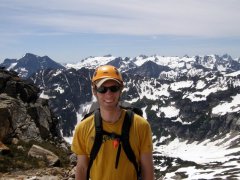
Here's a panorama I stitched together. Taken from the summit. -
[TR] Liberty Bell - Beckey Route - 7/4/2007
jpasteris replied to jpasteris's topic in North Cascades
Got some pics from the summit. I'll try to get them up soon. I should have taken some of you guys climbing and rapping. Would have been some good shots. What route were you on? I remember doing the Cave Route last year, but I couldn't remember if that was to the right of where you were. -
A lot of the guide books call out the rappel into the gully via the rabbit ears. I agree with you though, the 4th class descent is pretty easy, and in my opinion, preferred.
-
Trip: Washington Pass - Liberty Bell - Beckey Route Date: 7/4/2007 Trip Report: Climbed the Beckey Route on Liberty Bell on the 4th. Spectacular weather made for a great day. Saw a couple other parties, but really not too busy. There is still some snow around, but it's melting fast. The approach to Liberty Bell is easily doable in approach shoes. The route was fun as usual. Cruised it pretty quick. Kristy led the first pitch for her first alpine lead. I took pitch two and three. We scrambeled to the top, took some pics, scrambled back down and rapped off. Two rappels with one rope make for an easy descent. We lit some sparklers to celebrate the 4th when we got back to our bags. Be careful scrambling down from the notch, it's a bit slick in places and you need to pick and choose the best way down. We saw some paragliders cruising the skies: A much better way to travel than surfing scree piles. Car to summit: about 4:45 Gear Notes: Small rack to 3 inches Approach Notes: Approach shoes are all you need. No boots, no axe, no crampons.