


cluck
-
Posts
517 -
Joined
-
Last visited
Content Type
Profiles
Forums
Events
Posts posted by cluck
-
-
I haven't read the official voted-on version, but here's what was in one of the most recent versions:
- Climbers must carry BOTH a locating device (MLU, PLB, or GPS) AND a 2-way communication device (cell phone, radio)
- The law only applies on Mount Hood and only above 10,000 feet
- The law only applies between November and March
- The law doesn't take affect until 2010 (to give time for technology to develop and drop in price)
- There is no penalty for being caught w/o the required equipment
It's impossible to enforce this law and the legislators know it. They just want to pass something, anything, to make it look like they're doing something to cut down on "climbing disasters."
On the positive side, it seems like the committee made a genuine effort to limit the impact this bill has on climbers. On the negative side, they seem hell bent on wasting my tax dollars to pass a meaningless, unenforcable law against the advice of all the stakeholders & experts simply to appease the percieved wishes of an ignorant and misinformed public.
- Climbers must carry BOTH a locating device (MLU, PLB, or GPS) AND a 2-way communication device (cell phone, radio)
-
This is just too much fun to leave alone. I've always wondered how the "old-school" practice of leaving gear on a project would hold up in today's increasingly crowded areas.
Consider this scenario: I'm working Chain Reaction cuz it's going to be my first 12c but it's kicking my ass and I don't finish it on the first day. So I lower off the 4th bolt, pull my rope and head out for the night. I don't bother to clean my draws because I'll be back to finish my project after a rest day or two.
Next day, some hot shot sporto shows up after doing laps on Scarface in his florescent lycra tights and wants to prove to his friends that he can onsight that "bitchin line on the cover." But shit, there's already draws on most of the bolts. That doesn't count as an onsight!
Of course - that's purely hypothetical. I'll never climb Chain Reaction. But still, there are more an more people out there climbing hard routes and there's no guarantee the gear you leave on the route won't be in someone else's way.
Don't get me wrong - I don't think it's ever acceptable to steal someone else's shit. But by leaving your draws on the route, seems like your just gambling that nobody else will come along before you return.
-
Sounds like you made a smart call. Bummer you didn't get to the good stuff, but at least it sounds like you had a fun day out in the hills. Thanks for exercising good judgment and not being the next cover story!
-
Forecast only applies as far south as the Mount Hood area, but you can reasonably estimate the snowpack in the Sisters area from that.
-
Damn - what an amazing trip! Truly spectular pics of what sound like some unbelievable lines. I'm inspired!
-
Nice - St. Helens is such a great mountain to ski/board off. Way to get after it!
-
Trip: Mt. Hood - Ski Tour: Cooper Spur --> Meadows
Date: 3/17/2007
Trip Report:
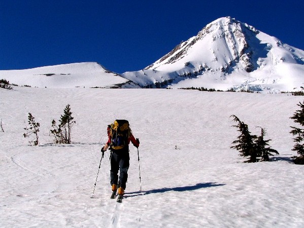
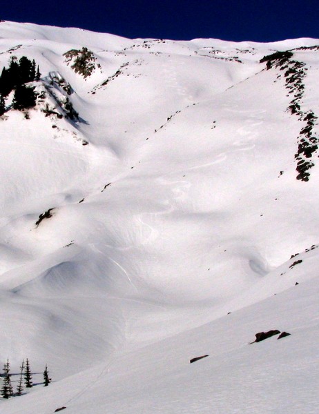
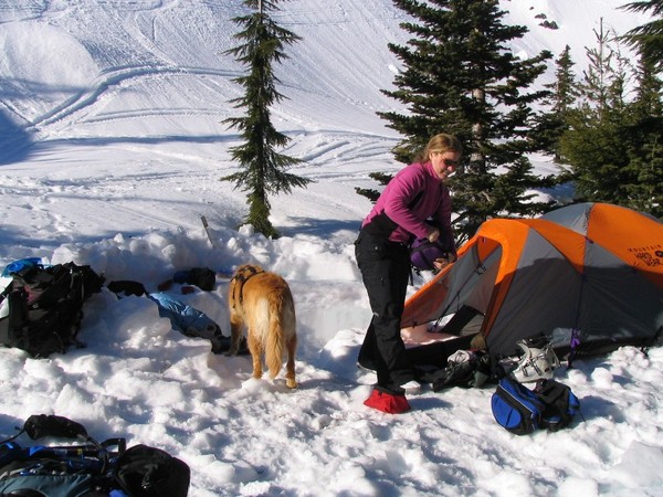
Took full advantage of a sunny Saturday to check out a ski tour I'd been pondering for months. The plan was to skin up Tilly Jane trail and continue up Cooper Spur to Tie-in-rock. Then ski around the east side of the mountain over to Timberline Lodge.
We get a nice "alpine" 8AM start from the trailhead and are breezing past the Tilly Jane cabin by 9:30. 2 more hours of skinning under georgous blue skies with stunning view of das Hoodwand brings us to Tie-in-Rock.
At this point, we are getting knocked around pretty bad by random wind gusts so we opt to start our descent right at the rock rather than continue along the ridge to the broad, flat area at the base of Cooper Spur route and risk getting blown down onto the Elliot glacier. This proved to be a mistake we would pay for later by regaining elevation on the Newton Clark Glacier.
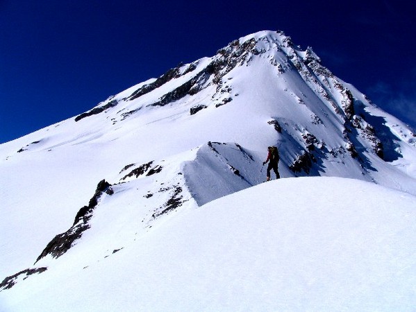
The wind is totally messing with us. We are on the leeward side of the mountain which means we should be sheltered from the prevailing winds... in theory. But what we experience is a mixture complete calm and random, hold on to the mountain to keep from getting blown off wind gusts that come sporadically from any directon. At one point, the wind blows my glove liner out of it's stowing place in my jacket and blew it 100 feet down the ridge before dropping it in the snow suddenly and returning to dead calm. I eye my glove cautiously as I peel off my skins and click into my skis. Slowly traversing over to recover the glove, I get tanatlizingly close when another random rogue gust picks it up and flings it over the ridge and out onto the Elliot glacier. Damn! Oh well, time to ski.
We enjoy a few buttery turns to get below a small rock outcropping and then start the traverse accross the Newton Clark Glacier. In a matter of minutes, we glide past Lamberson butte, above the Newton-Clark drainage, and over to Heather Canyon. Here we're faced with the decision to attempt to negotiate the broken cliff bands or climb up and ski above them. We opt for the annoying but more conservative choice and skin back uphill, regaining about 300 feet. In retrospect, had we initially continued on to the flat area at the base of the Cooper Spur route proper we'd have been in much better shape. Oh well.
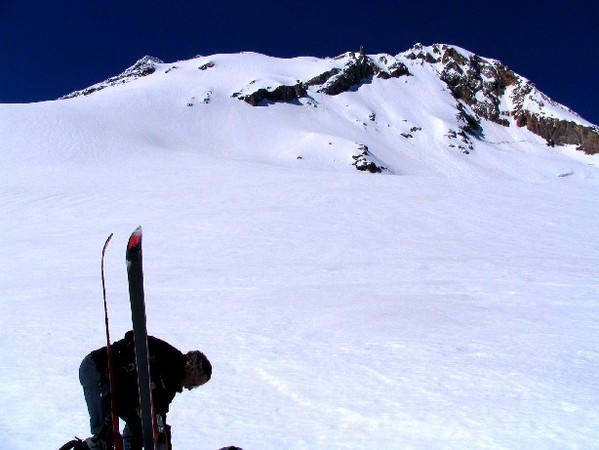
After stowing our skins a second time, we cruise above the top of Heather Canyon over to the ridge where we can look down into White River Canyon. We are greeted with a healthy blast of wind and ridge after ridge of brown scree. Forget this.
We abandon our plans for Timberline and opt for the "consolation prize" of dropping into the top of Heather Canyon and skiing back down to the parking lot. By 2:30 we're tipping back beers in the sunshine outside the cafe at the Hood River Meadows lot.

This turned out to be an excellent tour. The price for entry is 4500 feet of elevation gain, but it buys you spectacular up-close-and-personal views of Snow Dome, Elliot glacier, North Face gullies, Cooper Spur, the spider, Newton Clark Headwall, and Wy'east routes. Highly recommended

Gear Notes:
Superhero wife with a cell phone and a car to pick our slack-asses up! Thanks babe!
-
The much bigger concern here is access and how events like these can and likely will decrease ours. I hope you all are Access Fund members and are active within your climbing community including doing what you can to correct public opinion on MLUs (among other concerns currently affecting the climbing community)... write a letter to the editor, send an email, etc etc... it all helps!
Word. We all need to do our part to stop harmful legislation like this. If you need arguments for your letter to the editor/congressman, here's what PMR has to say on the topic:
http://www.pmru.org/pressroom/headlines/MLU&PLBStatement.html
-
I find it amusing how much confusion there is surrounding the various finishing options for the South Side route. I must admit that I'm not 100% certain either.
However, the fact remains that the Hogsback is shaping up differently this year than it typically has in the recent past and there will be many climbers affected by this during the upcoming season. I'd hate for someone to get hurt this season because they are expecting the usual walk-up through the Pearly Gates and don't know how to navigate safely through the new terrain.
Here's what the Hogsback looked like in 2003:
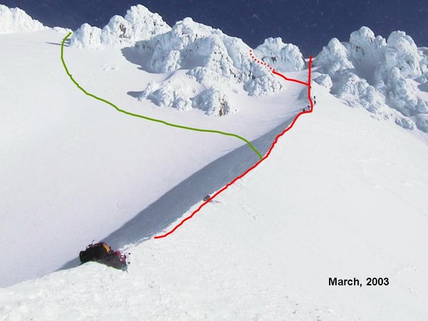
and here's what it looks like this season:
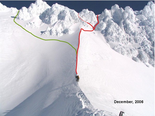
I've drawn in both variations of the Pearly Gates in red as well as the Old Chute (aka "Mazama Chute?") in green. Like others have said, the standard way through the Pearly Gates is the right variation and most years the Hogsback lines up perfectly with this.
At the moment, it appears that the Old Chute is the easiest way to the summit. Just keep in mind that this option exposes you to much more ice and rockfall hazard. But it does bypass the bergschrund which seems to be opening a bit early this year.
Feel free to jump in and correct me if I messed something up.
-
Damn - NICE pics dude. Slick move making your partner tote the camera so you get all the hero shots!
-
-
Ryland - I don't remember their lengths exactly but all appeared to be at least 50M. This was at about 8,250 on the west rim of White River Canyon.
Gary - good point. 450 feet of rope doesn't mean a 450-foot vertical drop. Most of the media has a hard time understanding the difference. Everything is either a "cliff" or a "trail."
-
Oh man - this is getting ugly. For the record, my team wore crampons for the walk from the Top of Palmer to the snow cave. The ground was a mixture of blue ice and snow drifts. It's just easier to walk when you have sure footing.
We also tied ourselves together. In the howling wind and limited visibility, it seemed a prudent way to keep from getting separated. It's tough to keep track of your friends when peering out from deep inside your parka hood through rime-ice covered goggles in 15-foot visibility.
Lastly, from the site where the 3 folks fell, one of our teams tied 3 climbing ropes end to end (~450 feet) and rappelled down to search. It wasn't vertical, but it was steep enough to want to rap. Even at the end of the ropes, our guy wasn't yet to the bottom of the canyon.
Hopefully this information will help scratch off a few items from the speculation checklist.
-
I just wanted to say 'THANKS' to all the gapers and sprayers and other assorted CC.comers who showed up for this event last night. You're support is very much appreciated!
Also, props to Timmay for helping us promote this event! Tim - you

Stay safe out there - and I'll see you in the hillz

-
Yeah Paul - "Mountain of Doom" has been keeping us busy!
Ryland - personally, I am against the legislation. I think government mandate to carry an "electronic signaling device" has both benefits and drawbacks.
Benefits:
* might make the "search" part of "search and rescue" easier in SOME situations
Drawbacks:
* might give people a false sense of security leading them to take greater risks
* might give lost climbers (and the general public) a sense that they are entitled to rescue regardless of conditions
* lost climbers who did not bring an electonic signaling device might be reluctant to call for help becuase they're afraid of getting into trouble
You'll notice these arguments are similar to arguments against charging climbers for rescue.
In my opinion, the drawbacks of a government-mandated policy outweigh the benefits. It would be nice if more people carried some sort of signaling device (MLU, PLB, or GPS+cell phone) but I don't think legislation is the answer.
-
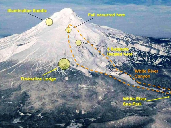
Too tired to read this whole thread, but I'll make a quick comment on the use of the MLU's on this mission.
The party of 5 had a GPS, MLU, cell phone and (I believe) a FRS radio. We used their GPS coords to figure out where they were and come up with a game plan for getting them. When we got close, we used the MLU to get even closer, and then finally the FRS to contact them and tell them to come out of the snow cave so we could see them. Finding a snow cave in a whiteout is freakin hard.
The part of 3 who fell had an MLU and a cell phone. We were able to use the MLU to estimate their position by triangulating based off of several readings from teams in the field. To get a reading, one must maneuver the MLU receiver to within a more-or-less line of sight position from the transmitter. That allows us to get an estimated bearing to the transmitter. When you combine several bearings from multiple locations, you start to get an idea of where they are. It took us most of the night to do this.
Of course, knowing where the subjects are is only half the battle. Actually getting to them and then getting them out is another story.
In this scenario, the MLU was another helpful piece of technology and it was used to help locate both parties. I'm glad they had them because it made our job easier. I'm also glad they had a GPS and a cell phone.
-
If you parked at Marble Mountain snow park and took that packed out snowshoe/cross country ski trail then you probably climbed the Worm Flows route. That is the standard route in the winter because the road to the Climbers Bivouac is closed to snow. It actually joins Monitor Ridge for the last few hundred feet to the crater rim.
Climbing the Monitor Ridge route in the winter would be somewhat out of the ordinary - and that's why it piqued my curiousity. You'd have to work pretty hard (or make friends with the slednecks) in order to make it over to Monitor Ridge proper.
In any case, the turns down are sa-weet!
-
Climbed Monitor Ridge, huh? Where'd you park?
Looks like a great day in the hills - thanks for the pics!
-
Very cool! I love reading TRs of the slightly more obscure routes on Hood.
-
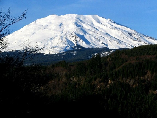
Trip: Mount Saint Helens - the usual
Date: 1/28/2007
Trip Report:
Corn in January may be abnormal but it's great anyway!
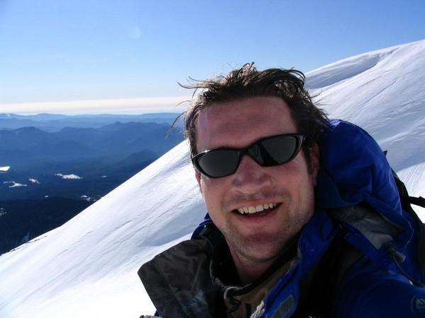
Goofy self portrait:
First tracks. Yeah beeyotches!
The last few turns into camp:
http://vids.myspace.com/index.cfm?fuseaction=vids.individual&videoid=1836698489
I guess it was pretty icy on Saturday. Bummer. Sunday was the bomb! Saw Pandora and others at the top. Hope you all had as much fun on the way down as I did.
Gear Notes:
Umm. Skis...
-
Boots:
Something warm and waterproof. No real need to rent plastic boots if you have adequate hiking boots. But you'll likely be hiking through snow for much of the route and it's very cold in the morning up high.
Permits:
Needed to climb above 7000 feet. You can pick one up at the ranger station in Trout Lake on your way in. They do not limit the number of permits issued.
Roping Up:
I've never heard of anyone roping up to climb the standard south spur route but you're a better judge of your snow climbing ability than me.
Crevasses:
Never seen (or heard of) any on the south spur route. There are crevasses on other adjacent routes so that could be a hazard if you get lost and wonder waaay off route.
Mtn Sickness:
Can be a real inconvenience up there. You're not likely to die of cerebral edema but lots of folks get AMS. Learn to recognize the symptoms and exercise good judgement on when to turn back.
Other Hazards:
If you choose to glissade down (sitting on your butt sliding down feet first) for God's sake take your crampons off first! Seems like someone snaps a leg every year doing that.
If you do your research and plan carefully, you'll likely find Mount Adams a pleasant and technically easy (though physically demanding) hike. Best of luck!
-
Thanks for the link Sobo.
What everyone has failed and will continue to fail in this "cost" is what are the incremental costs for a rescue.
For example, if a sheriff was not coordinating the rescue, he would still get paid becuase he is salaried. His cost then does not get factored into the rescue becuase it is not an incremental cost. Military personell will still be training, so their cost does not factor. The only incremental cost I can think about is hiring personal contractors for each mission, and the incremental fuel for the missions.
The sheriff sprung for a few hot meals for the volunteers. Plus, some of the deputies were probably scoring a little overtime. Seems like a pretty light burden on the John Q. Taxpayer. Amusing how we end up defending ourselves against the same questions year after year.
Still, it looks like we may be gaining some ground. This time KATU news ran a very intelligent story from our point of view. I was so proud.
-
Here's some beta on the Hogsback route:
My advice to a first timer would be to
1 - wait until May or June
2 - hire a guide or go with someone who knows what they're doing
-
 Thanks
Stealing fixed draws
in Climber's Board
Posted
Hmmmm.... I guess that explains why I always see draws on that route. I just figured someone was working it!