


Tennessee
-
Posts
82 -
Joined
-
Last visited
Everything posted by Tennessee
-
[TR] Exfoliation Dome- Jacob's Ladder 8/5/2006
Tennessee replied to Dirtyleaf's topic in North Cascades
Nice! Is this route written up in a guidebook? Sounds familiar but couldn't remember. What is it rated? -
Hey slc heath, that is my friend's stuff. Funny I saw this, as her and I did Serpentine Cracks yesterday to try and get it back. I was perusing the site and saw your post. I can (or she) can describe the gear, and can describe why the hell it was left up there. the short answer was an epic from stuck ropes actually on the way up (followers rope stuck in a flake, you probably saw that too) and getting caught in the dark. PM me with your email or something, I'll do the same. Thanks a lot, I'm sure she will be super happy to get her gear back, she is definitely not rich and climbs all the time, so they are in desperate need. thanks so much.
-
Here's some beta for climbing in Thailand: -don't spend more than one night in Bangkok, there's a reason for that song -pay up front for all the days you plan to stay in a bungalo, you get a cheaper price -don't stay in the places near the beach unless you can afford it, inland places are cheaper. Dream Valley is a good bargain. -bring lots of chalk -bring all anodized biners, or else they get destroyed by the salt water environment -don't bring a bunch of shorts/tshirts, you can buy cooler ones in Bangkok for cheaper and they make good souvenirs -Bring a sweater or jacket on the bus ride from Bangkok to Krabi, they crank the AC and it gets too cold to sleep -you can buy pot from the bartender at the Insomnia Bar -always bargain and don't offer a price that you aren't willing to pay. if they accept your offer, you should buy it or they get really pissed -don't buy any drugs in Bangkok -learn some Thai, even a little makes a good impression -visit the Northern part of the country if you have time (Changmai, Pi) although with 2 weeks you'll probably stay in Railay the whole time -bring some strong antibiotics like Cipro and Flagyl -find the underwater cave entrance that tunnels through Happy Island, a very cool adventure -always stare down the bearded monkeys, they love that -make time to climb Ao Nang Tower, it's worth it -get a posse together and rent a boat to do some deep water soloing near Chicken Island -beach towels are as expensive in Thailand as they are here, and they all suck -you can get mosquito repellant there -if the tide suddenly goes way way out, run
-
http://www.skipressworld.com/us/en/daily...l?cat=Adventure
-
Has anyone out there done NF of Buckner? I'm hoping to get some beta on the approach via Sahale Arm, up and over Boston Peak and onto the Boston Glacier. Or if you highly recommend the Sharkfin Col approach instead, I'd be interested in hearing why. Are there any points of reference or an elevation where you need to make the crossover onto the Boston Glacier? Basically I'm thinking of camping at the Sahale highcamp and doing the North face of Buckner with summit packs only, then descending the Southside of Buckner and return to camp via Horseshoe Basin. It looks straightforward, but is there anything to watch for as far as terrain barriers or places that cliff out on the way back to camp? thanks.
-
was this with the Bellingham Parks and Rec?
-
Jason gave some really good advice. American Alpine Institute has been guiding in Bolivia for like 26 years and offers a pretty flexible trip: http://www.aai.cc/ProgramDetail.asp?program=11
-
I got some great beta from these guys http://www.wildirisclimbing.com/ It's the climbing shop in Lander. I emailed them last year about the Winds and they gave me excellent info. I'm sure it all depends on who answers the emails, but there seems to be some pretty knowledgable climbers working there. It might be worth a try . . .
-
Don't forget about all that paperwork and red tape to get a Special Use Permit on Forest Service, BLM or National Park land. $1,000,000 minimum liability insurance requirement, application fees, user fees, and complicated annual reports. (Unless you are going to guide on hwy roadcuts or private land)
-
Yes, that first pic looks like DP. Was that second pic taken of the climbs to the right of DP or to the left? A couple friends went back up to climb DP again this sunday, but decided not to lead it. They did, however, set up a belay at the tree at the top of the climb and tr'ed it. They were glad that they didn't lead it, as the ice was steep with that rotten crust over it and there wouldn't have been much pro at all. After talking with several folks who have done routes up in this area, it sounds like these conditions are pretty normal.
-
That might be the one we climbed, not sure. It is pretty accessible and lot's of folks ski up there, I'm sure we weren't the first to try it. There's also another WI3 around on the northeast side of Table that's been climbed, listed in Jason's WA Ice book. I remember looking at it on Sunday, but when we went back on Wednesday it didn't look as good, maybe it just got covered in snow, being so low angled.
-
True Death Picnic was scary looking, but that's just to me. I bet a good ice climber wouldn't say that though. I'm just not good enough to cast off on ice that steep this early in the season. Besides the first 40 feet on cauliflower steppy stuff, the rest looked pretty fat and blue. And it isn't that the mixed lines aren't touching down, it's that they are just thin. There's tons of lines that go all the way down, but you wouldn't be able to get many screws in, if any. If you had a 600 foot toprope though, they would be a blast.
-
...
-
After skiing around Table Mountain (near Baker Ski Area) on Sunday and seeing many nice looking ice climbs, we went back up yesterday and climbed a 2 pitch route, 2 gullys to the left of Death Picnic. Our original intention was to climb Death Picnic itself, as it's definitely the most obvious and fattest line around there right now. But it's very steep and the first 40 feet or so is on cauliflower-type formations that are like little overhangs. There's also a crusty kind of ice formed over everything that isn't dead vertical, so you don't know what's underneath until you swing. . . sometimes good ice, but sometimes it's sugar snow or rock. Death Picnic looked too steep for our taste and we chose the other line. DP looks like a solid 5, our line went at about 3+ with marginal pro, but good enough. There's lots of other potential ice and mixed climbs up there. If it doesn't get too warm over the next few days, they should still be in pretty good shape.
-
We hiked in to the Hidden Lake Peak/Sibley Creek trail (the beginning of the Triad Approach to Eldo) and climbed a bunch of FAT, easy waterice climbs on Sat and Sun 11/8-9. There was so many frozen creeks you couldn't climb them all. Nothing any harder than a 3. A couple major multi pitch flows were accessible with only a mile and a half approach. I'm sure they are gone now with the warm weather and rain from Monday and Tuesday. . .
-
Mount Baker-Snoqualmie National Forest is considering closing or decommissioning several roads around the Baker Lake Area. They are trying to close roads that are difficult or expensive to maintain. Two roads that are of note to the climbing community are: 1. FS Road #1152-014, this is the last road you turn right on when driving to the Sulfide Glacier Approach on Shuksan. They are considering 3 options: leave it alone, close it, or upgrade it. If it gets closed, the approach would become about 1.5 to 2 miles longer, I think. 2. FS Road # 1131- This is the last road you turn left onto when driving to the Boulder/Park Cleaver approach on Mount Baker. This is of note because this is not only a great moderate route on Baker, but it's also one of the best ski descents on the mountain. The road closure would add many many miles to the approach. You can write Mount Baker National Forest and express your opinion on the potential closures of these roads. (many other roads are being considered, but these two are the only ones I saw as being important to climbers/hikers). The main problem for us, obviously, is that we would have to walk a lot further to gain access to these moderate, classic routes. However, an argument that may hold more merit for the Forest Service might be that by making the approaches longer, they would inadvertantly be ADDING traffic and human impact to the other heavily trafficked areas around Mount Baker and Mount Shuksan. Namely the Easton Glacier. If you find this to be important to you as a climber or hiker, please take the time to write to the Project Supervisor, Karen Nolan, at: Mount Baker/Snoqualmie NF Mount Baker Ranger District 810 HWY 20 Sedro-Woolley, WA 98284 I just spoke to her on the phone and she was very nice and responsive to my comments. She said that hearing people's opinions on it would certainly influence their decisions on what to do. She was interested in hearing what the public wanted. So please make your letters polite, short and to the point. She'll be more likely to read them probably. Thanks.
-
. . . if it did we wouldn't need to advertise it, now would we?
-
Full Charge Bookkeeper needed at a nationally recognized international mountain guide service. Informal office 25-32 flex Hours/week. Automated accounting & Excel exp req. payroll exp preferred. Send Resume and Cover letter via email to lparberry@aai.cc, or fax to 360-734-8890.
-
No problem, but thanks for the beta. People should note that you can't walk off any of the routes on the Chief, because of the backcountry ban in BC, and possibilities for descending are limited depending on what route you climb. We rapped off Uncle Ben's after topping out on Bellygood ledge. It was a straight forward, plumline rappel, even though it was super exposed. Oh, and thanks for the compliment, but I'm actually American.
-
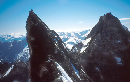
Thanks Fern for posting those. I'll have to figure out how to do that. Beta: after 4.5 miles on the overgrown logging road (where it abruptly ends) follow the trail going right up the hill where the big cairn is. DO NOT follow red flagging tape that goes straight. Follow trail until you can't see it any more. Then go up, up, up, traverse, traverse, up, up, traverse until you break out of tree line and into heather meadows. After a lot more traversing you will see a wide notch in the ridge above you (there's a narrow notch to the left of the wide one that you don't want to ascend). There will be a large tongue of snow leading up to the wide one and a large rock buttress coming off it's left side. Even further left of the rock buttress will be views into the Southern Pickets and the Terror Basin. Go up to the notch and then drop down snow fields into the only flat spot for miles and a most perfect campsite with awesome views of your objective climb. As for the climb itself, there's 3 pitches of sparsely protected 5th class climbing until you reach the ridge and gain your first views into the northern Pickets. Once on the ridge, here's the best piece of beta: There's a very large, phallic rock protrusion on the ridge just where it becomes steep. It creates a big roof. GO RIGHT of the roof and up and around the corner a bit for a short pitch of 5.8 or so. Then you'll end up on a little ledge on the right (Northern) side of the ridge where the incredible, wavey 5.9 handcrack splits a sheer wall. After that you are there. KILLER traverse from E to W summit, here's where you'll want to take photos. Descend your choice of routes on the W ridge. If you remember nothing, remember to go RIGHT at the big protruding roof. We climbed it in 2 teams of 2 and one of our teams went left of the roof and ended up in some 10+ overhanging corner with lots of lichen and a chimney. Upon hiking out, go to Good Food in Marblemount and try to eat an entire Mountain Burger. It's almost as hard as the climb.
-
OK that didn't work. Just click on the "attachment" link above. I can't figure out how to make it show up in the post. . .
-
I'm going to try to post a couple of pics from July 2001 . . .

-
If you are going all the way in there to climb Inspiration, do the East Ridge for sure. There's a handcrack on it that is worth the whole approach. And the summit ridge traverse from the East summit to the West summit is one of the most photogenic areas in the Cascades. As for the descent, we did 2 or 3 double rope raps off the summit, down the West Ridge. Then at the point where the W ridge just flattens out a bit, we started rappelling down the South face. It is pretty vertical and we figured there would be less of a chance of getting ropes stuck. (Plus only one of us carried boots, so the other 3 would have had to downclimb that snow gully in rock shoes). There were no other rap stations anywhere on this part of the south face, but the rappels went fairly well even though we had to leave tons of stoppers and slings. I haven't done the regular descent off the W ridge so I can't compare the two decents, but now that there's rap anchors built on that part of the S face, it might be worth considering. If you want beta on the climb let me know. my 2 cents . . .
-
Ivan, I've been called worse, that was actually pretty funny when I heard Climbzalot up at the belay say he was climbing with "Andy" and you said"Did you say Amy? , you've got a girl up here?" That was some funny shit. Yeah, I left my summit smoke back in the car, it keeps me from being tempted on the hike in. I can barely keep up with Hikezalot as it is! But I spent sunday catching up.
-
Eric and Ivan, Just want to second what Climzalot said. . . nice to meet you guys and thanks (to everyone) for stomping out the trail. I don't say that sarcastically at all, while we were hiking out we mentioned several times at how lucky we were for having it stepped out. We could not have done it in the time we did without the trail kicked, that's for sure. Also, that was a really nice example of how multiple parties on an alpine climb, though not ideal, can still make for a fun day if everyone is courteous and friendly. It was refreshing to have it that way as opposed to everyone giving each other the evil eye. Bitchin' route by the way. No wonder it's considered a classic.