


Norman_Clyde
-
Posts
853 -
Joined
-
Last visited
-
Days Won
2
Content Type
Profiles
Forums
Events
Posts posted by Norman_Clyde
-
-
Oly NP: Mt Washington
MRNP: Pinnacle or Castle Peak
NCNP: Hannegan Peak
In that order, or the reverse.
-
The most out-of-the-way place in the Cascades.
You have just made it irresistible. Only a matter of time now.
-

 Rah Rah Rah! Sis Boom Bah! Tatoosh Tatoosh Rah Rah Rah! Strong work, guys. Can't have too many of those dawn to midnight suffer fests.
-
I've never tried it but I think the idea is to place a picket, tie in to one end of the rope, clip the rope through a biner on the picket, connecting the other side of it back to your harness with a prusik; then cross with the rope in a loop, feeding it out as you go. Once across, you can pull the rope through. Repeat as necessary until you run out of pickets. Reverse the procedure on the way down, but you'll have to leave pickets on the uphill side. Or dig a big bollard on the uphill side and you won't have to leave a picket.
-
Thanks, guys. Just the info I was looking for.
-
My father and brother are joining me for a non-summit oriented weekend camp in MRNP in September. Both of them are agile, familiar with snow travel, but neither is up for any technical glacier work. I want us to be able to hike as high as possible, but we also are seeking a degree of solitude, hence Muir snowfield is out. Having never been to Glacier Basin or Schurman, I have a couple of questions for the board:
Is it possible to hike all the way to Schurman unroped without any significant glacier travel? We will probably be in running shoes with trekking poles, and while we may feel fine bypassing a few crevasses on a low angle boot track, snowbridge crossings will be out. I have heard that the Inter Glacier is no big deal, yet it seems to swallow an unwary glissader every few years.
How scenic is Glacier Basin? Is the opportunity to hike to Schurman worth passing up a night at Summerland or, say, Granite Creek? Will Glacier Basin be crowded with climbers at that late date?
Thanks.

-
Is the West Fork Dose bridge still out?
-
16 hours 56 minutes (3:25 AM to 8:21 PM). We had our first meal in Forks at Chez Tesoro, a real high class place. Sun chips and Powerade for me, hot chocolate and cookies for Sky. My original plan was to leave baguette and Brie in the car to eat on our return, but I ate it on the trail and summit instead. I'm concluding that high fat is the way to go!
-
I'd say that glacier conditions are highly unlikely to have deteriorated significantly. There is almost no crevasse negotiation required, no snow bridges at all, only end runs or the occasional zig-zag between adjoining cracks. The furthest we had to deviate from a straight line was one hundred yard end run on the back side of the peak. The lowest part of the glacier is very heavily crevassed, but this far down in the ablation zone, the crevasses have little or no depth, and the only hazard is the occasional sinkhole. Ice is hard on this portion, and crampons are helpful, otherwise you could get by without them.
Trail essentially extends right to the glacier. The only "off trail" is the glacier side of the lateral moraine, which is an unconsolidated pile of dirt and rocks, only about 300 vertical feet. Running shoes are fine for the trail, probably OK for the whole climb except your feet will get wet. I carried Vasque Sundowners for the snow and ice both times, and in my opinion it was worth the extra weight to be able to change shoes between trail and climb.
-
I've only found two balloon carcasses so far. I must not get out enough.
None of you dissing SUVs better use an old Jet Ski or snowmobile or outboard motor or other 2 stroke that burns oily gas. They pollute about 100 times more per mile than an SUV.
The above is not intended as a defense of SUVs, which are a disgusting symptom of the generally wretched excesses of overconsumption and ego which this country represents.
-
I've only been up there once, just hiking to the summit with my kids, in a very pleasant mood which was made quickly less so when I read the engraving on the fancily prepared polished monument by the parking lot. I figured I was going to read a little local history, maybe about someone called Erie that the mountain was named after. Instead I get to read about some poor unlucky or unwise teenager who went up there for fun, and fell off it to his death. Sort of a cross between memorial and public service announcement. Some people may need gentle reminders that a high cliff is dangerous, but I sure don't.
-
But why risk downclimbing that cruddy rock at the top? If you had a light rope you could rap off the usual way.
Our rope was only 37 meters long, so we couldn't have rapped the whole way down. It's true that downclimbing the vertical portion carried some risk, but compared to standing on the moderately exposed summit ridge, pulling pack off to access rope, setting up rappel, rappelling, pulling rope while standing on chossy semi-exposed ledge, I don't think that a little downclimbing was objectively more risky. I prefer to rappel as little as possible in general. It would have made sense to rap the north side directly to the highest snow slope, and our rope probably would have reached, but a party of five was ascending it and we didn't want to crowd them.
-
Quite an accomplishment indeed! Your TR inspires me to go for it next year with a 24 hour goal in mind, but considering the condition of my feet after 42 miles this Sunday, I want to know: how much did it hurt? What part of you suffered the most? What kind of footwear did you choose? What was the longest training hike you took beforehand?
-
We climbed the summit block unroped, starting from the end of the chossy traverse without ascending the last snow finger. There are only a few vertical portions, and though the small rocks are loose, the larger ones stayed in place. Having felt pretty relaxed simulclimbing this last year, as well as downclimbing it, I was surprised to find I felt pretty sketched in places. It wasn't a matter of the climbing being so difficult, but rather that on the vertical portions you have to yard out pretty hard on blocks that have a likely potential to move-- and if they did, you wouldn't just slip, you'd launch yourself. I decided to descend via the snow finger, and noticed that on the northern aspect there is a pretty easy looking chimney heading directly to the summit. This was not the route that the roped climbers were taking; I never got a good look at that one.
-
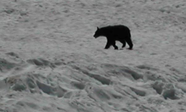
Here's the bear.
We also found a crumpled 55 gallon drum on the lower Blue Glacier. I figure it must have somehow made its way there from the UW glaciology station on the Snow Dome. I can't really think of any other reason for it to be there.
-
Skykilo and I made the round trip from the Hoh parking lot yesterday. Left Seattle around dinnertime, got to the parking lot about 11 PM, bivvied in the next adjacent parking space until 3 AM. Weather was perfect. We kept a fast walking pace with short breaks. Hit the summit just after noon. We never did rope up, and I only used my axe to glissade down the uppermost snow slope, otherwise we used only poles the whole way. Did not bring skis, but enjoyed some standing glissades down the Snow Dome. Did not consume any Gu, unless Brie cheese counts as Gu. Saw a medium sized black bear crossing the lower Blue Glacier-- I'll post a photo.
Overall I feel less tired after this year than after doing it last year, but the distance took a physical toll in much the same way-- on the trail descent my feet started to hurt about 12 miles from the end, getting worse with each mile, until the last 6 or 7 miles were pure misery. It's exhilarating to get all the way to the top of Olympus in half a day, but you pay for it on the way out. The trail is just too long for it to be all fun. Until I figure out how to make my feet tougher, I think I will limit my day trip mileage to maybe 10 or 12 miles from parking lot to high camp.
-
No kidding. I felt extremely conspicuous hanging about the parking lot, scrutinizing every passer-by. But no one got the wrong idea. (Back in Dallas in the 1980s, there were places on my running route where I couldn't even stop without getting hit on-- but that's another story.)
-
Around the lake is 2.8 miles. I average 6:30 per mile or so, but I usually slow down if I'm running with someone else. My house is a mile from the lake, so with one loop around I get a 5 mile run. More than once around gets boring.
-
Distel, I missed your last message. Waited at the SW corner of the W parking lot but didn't see anybody, so I ran on. Too bad. There's always next week.
-
West end by the bathhouse, you mean?
-
Thursday AM 6:30 fine with me. I will wait by Evans Pool/ community center/parking lot.
-
CBS, I agree with you about the N. Face seeming harder than 5.6, especially the second pitch which has no clear line to follow, just an odd bulge here and there. I ended up wishing that my partner and I had taken the Cave Route, which looked a little harder on the first pitch but supposedly is not too bad after that. The start looked obvious to me: traverse the ledge system westward, staying level as the gully drops away, for about 40 feet, then proceed upward, with the crux being a blind reach to gain the upper part of this same ledge system.
-
I can't tonight, but I'll meet you there at 6:30 tomorrow AM if you're up for it.
-
People with anorexia nervosa have low body fat, for sure, but they also have an extremely low body mass, i.e. their muscles and other vital tissues are wasting away because they are indeed starving. Your average male climber with low body fat percentage may be lean, but he probably has enough muscle mass for an above average body mass index.
Too late to edit into my last post!
Hero Worship
in Climber's Board
Posted
Lowell, thanks for a great link. I might have thought I knew the names of all the important historical mountaineering types, but sure enough here comes another. It seems there is no end of interesting historical personages in this state! Viewing photos like Watson's are a great way to time travel to the wilderness of Washington past.