


rat
-
Posts
653 -
Joined
-
Last visited
-
Days Won
3
Content Type
Profiles
Forums
Events
Posts posted by rat
-
-
Well, this is gonna be interesting....
The website is https://statisticalclimbingguideforfredbeckey.webador.com/articles and was also posted then deleted on NWHikers.net. The links to the articles don't work for me now.
Prior to the abrupt about-face, I skimmed through Chapter 18 regarding his Army service & discharge. It painted a less than flattering portrait but seemed to have plenty of documentation.
Mr. Creeden has also posted other interesting historical info on NWHikers.
AI spoof (seems unlikely but wtf knows these days), the heavy hand of moderation, legal threats, and/or just second thoughts and wanting to save it all for the definitely "not published by the Mountaineers" book? Inquiring minds want to know.
-
On 1/16/2024 at 10:52 PM, Kayleighm said:
Spotted a climb north of US 2 in Merritt the other day. Went to check it out today and a good chunk of the upper section looked airy and like it would be hard to get in good pro. Seeing as none of the group has had a day swinging tools this season we decided to save it for another day (if the PNW ice gods allow).
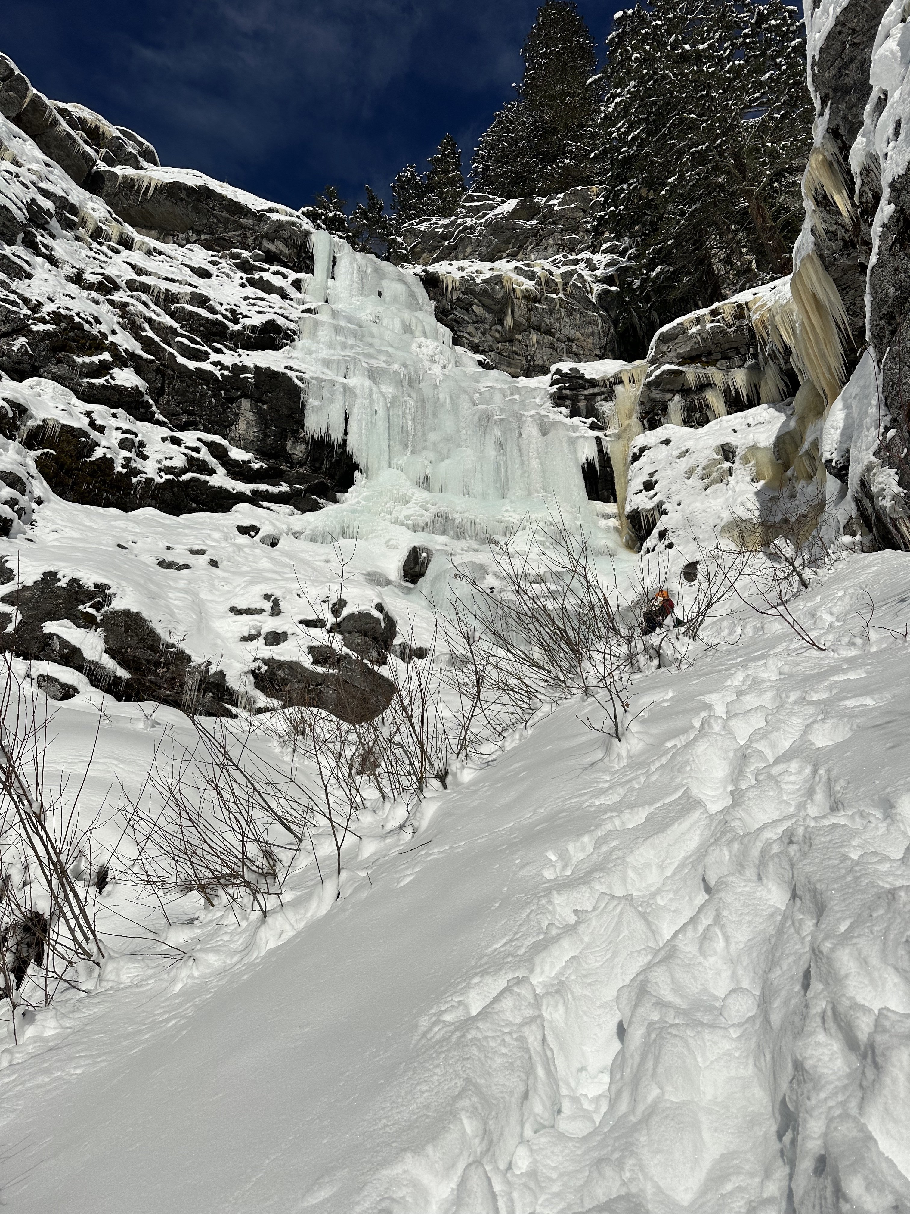
Does anybody know what route this is? Looked around MP and such as well as the Washington Ice guidebook. Washington Ice had two climbs in the Merritt section but this one doesn't quite match up to either.
Kicking myself a little bit because I feel like I could have led it BUT always erring on the side of caution with ice. Hopefully it sticks around long enough and solidifies!
Thanks for any info =]
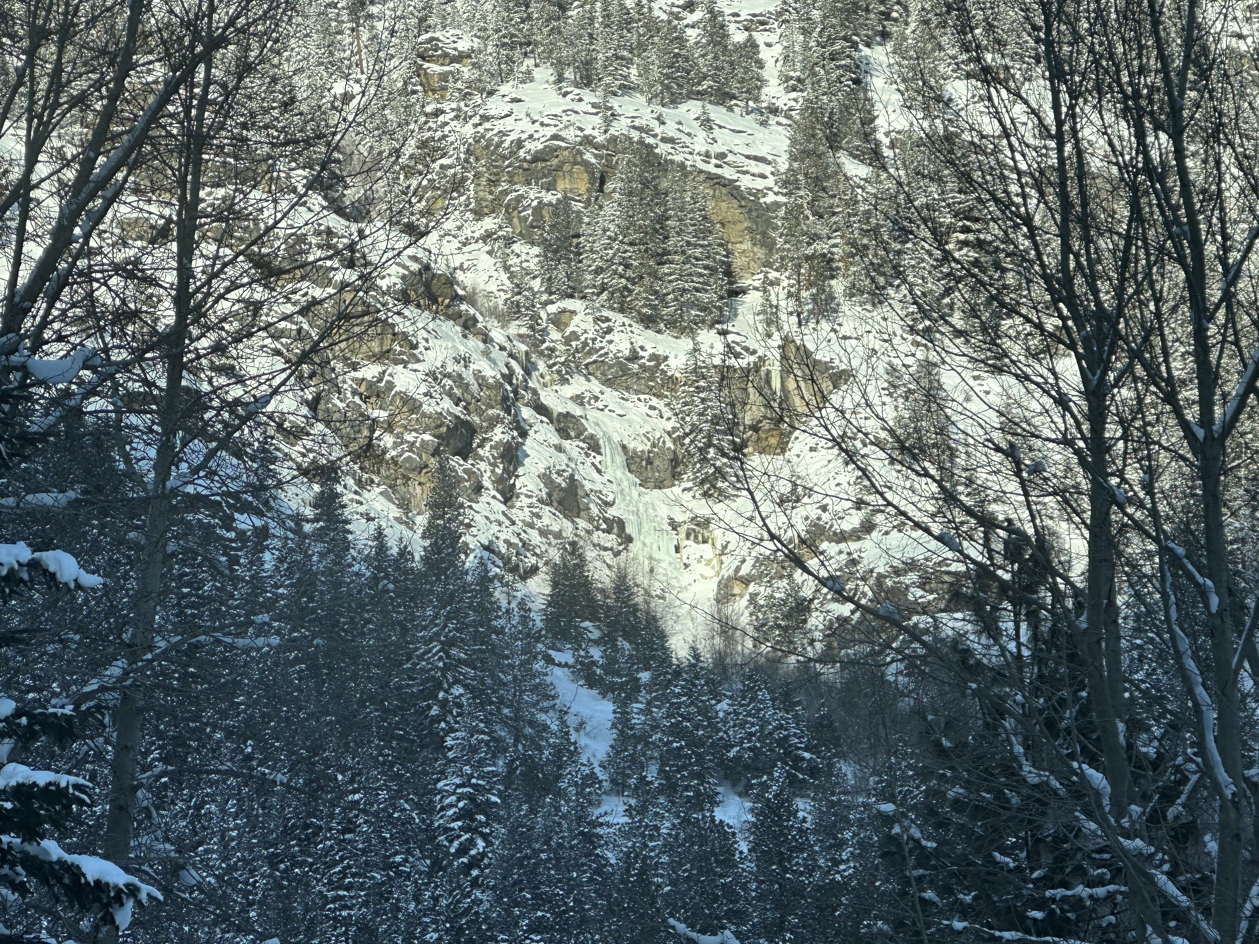
This is the main part of Chandelier Falls. Some stuff also occasionally forms just to the west. The old Chandelier Cafe is a bit east of here. Last time I was in the area, access had become somewhat complicated by new houses near Hwy 2.
There is also an ~2 pitch route north of the Hwy2/Whitepine Cr. Rd. junction that is high up on Nason Ridge. This is difficult to see from the road. You'll want skis or a supportable crust.
-
The title pretty much says it. Thanks.
-
Swamp Cr. & Pine Cr. are about the same distance & elevation gain. Swamp Cr. was preferable to Pine Cr. but we may have just been knackered by the heat/bugs when going up Pine.
Blake Herrington had an amusing write-up on his blog as did Rad Roberts here.
-
 1
1
-
-
Not sure but they're probably a combination of older & newer efforts by Cle Elum/Ellensburg locals. Maybe also some contributions from the Tacoma crew that did routes in the Swauk Pinnacles (late 90's if I remember correctly). But you already knew that.
Leland Windham et. al. have been active up the North Fork.
You'll also find numerous small sandstone pinnacles along side roads (e.g. Shaser Cr.) of the Old Blewett Pass Hwy. Leavenworth locals played on those in the '80's.
-
Sorry, it already went to Goodwill.
-
That person is lunger.
Sounds like you haven't heard of my alpine skipping workout, soon to be featured in all the Uphill Athlete programs. Plyometrics, baby, plyometrics.
-
 2
2
-
-
I think you might be mistaking me with that classic "Sound of Music" photo featuring a less crusty Mike Layton.
Nice pics.
-
-
Still shooting film?
https://photothinking.com/2018-02-16-minox-35-gt-little-big-camera/
Mint condition w/ hard & soft cases but needs a battery. Free to anyone that's actually going to use it. I strongly prefer a local exchange (Seattle to Mt. Vernon/Woolley) but will mail it if you pay the postage (& insurance if you want it).
-
1
-
-
Not sure if those words are directed at me...
When parapenting/paragliding gained traction in the the US in the early 1980's it didn't take long for people to start flying off peaks in the wilderness (especially around the Enchantments) not to mention jumping off El Cap. The USFS & NPS quickly kiboshed it using the Wilderness Act. This prohibition has been in effect for a long time & I wager that most, or at least most longer-in-the-tooth, climbers know this.
The purpose of my post was mostly educational. I'm ambivalent about that rule and many others. However, it doesn't seem wise to break a Federal rule, even unwittingly, then continue to post the evidence online.
Drone use is also prohibited...except by permit. Go figure...
-
1
-
-
Nice job.
For anyone headed in that direction, the McLane finish on Nooksack is nicer than the uppermost portion of the Beckey-Schmidtke.
I've seen a couple of reports of people flying off Shuksan & Baker. My understanding is that you can fly over national parks but not launch or land in them. Isn't Shuksan in the Stephen Mather Wildernes of NCNP? https://www.us-parks.com/nps/stephen-mather-wilderness.html If so, see the Wilderness Closure section here https://www.nps.gov/noca/learn/management/superintendent-compendium.htm#permit activities Or maybe the launch site is outside the boundary?
Yet another reason to abolish the park to make way for Segways.....
-
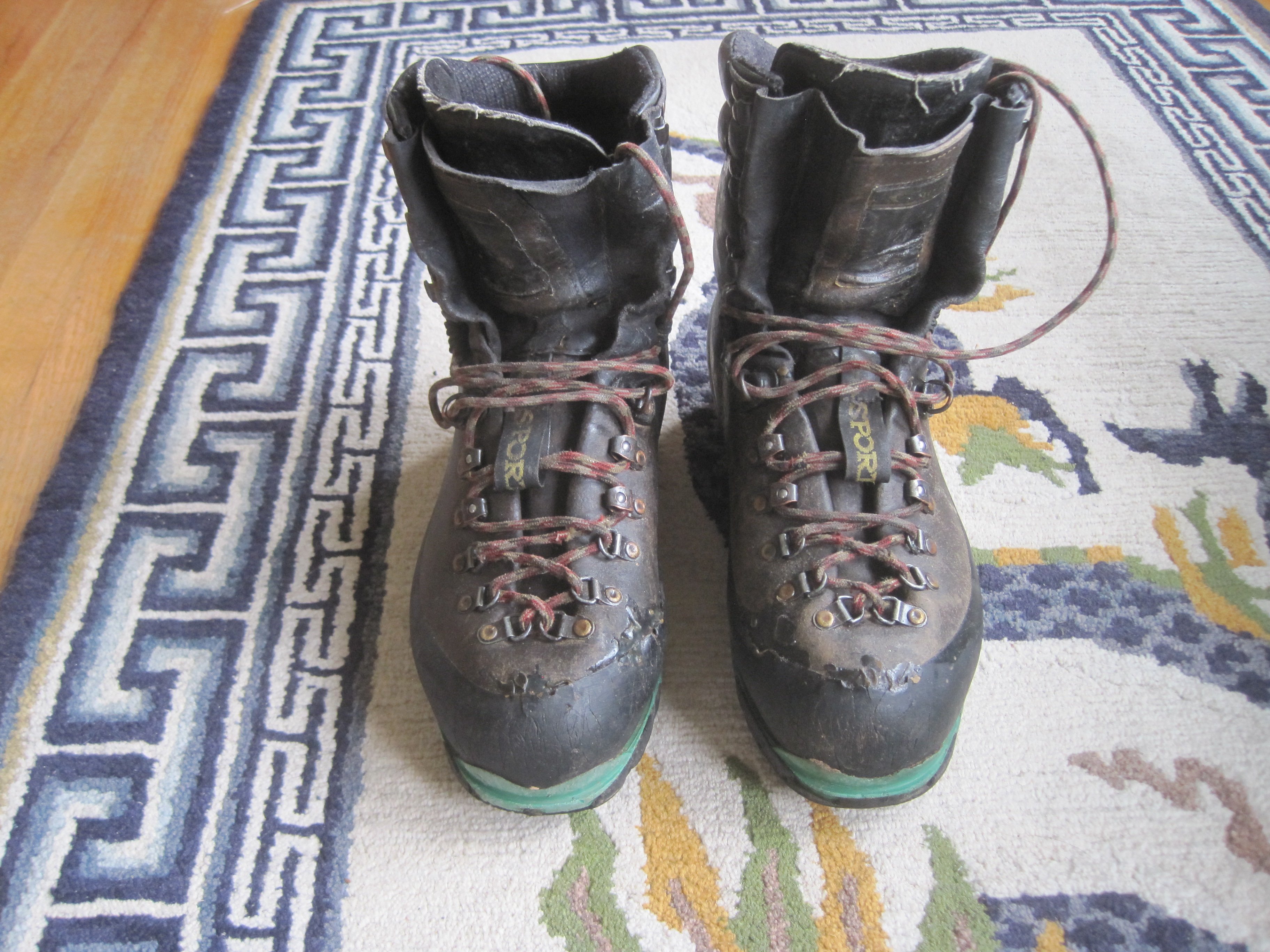
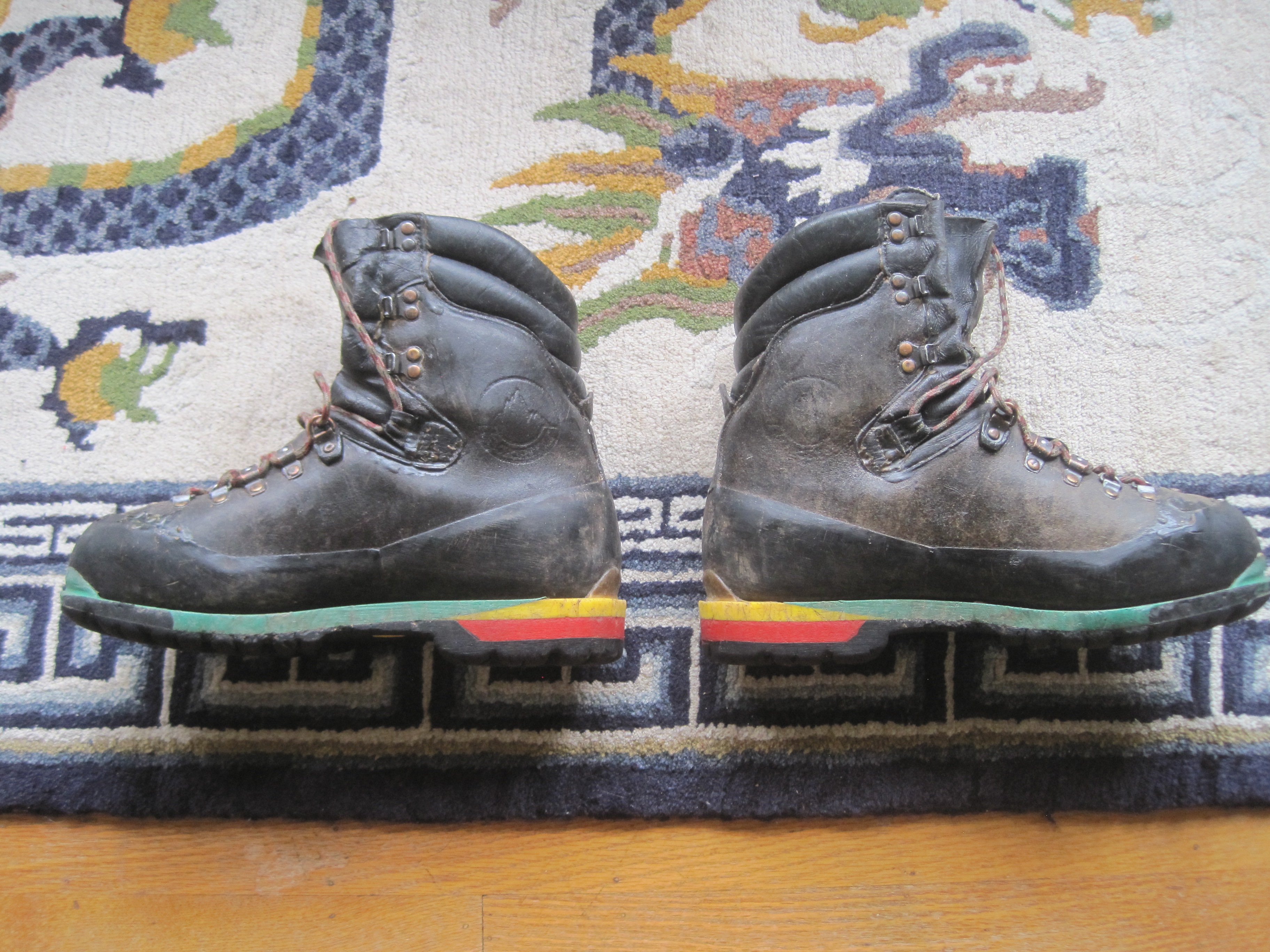
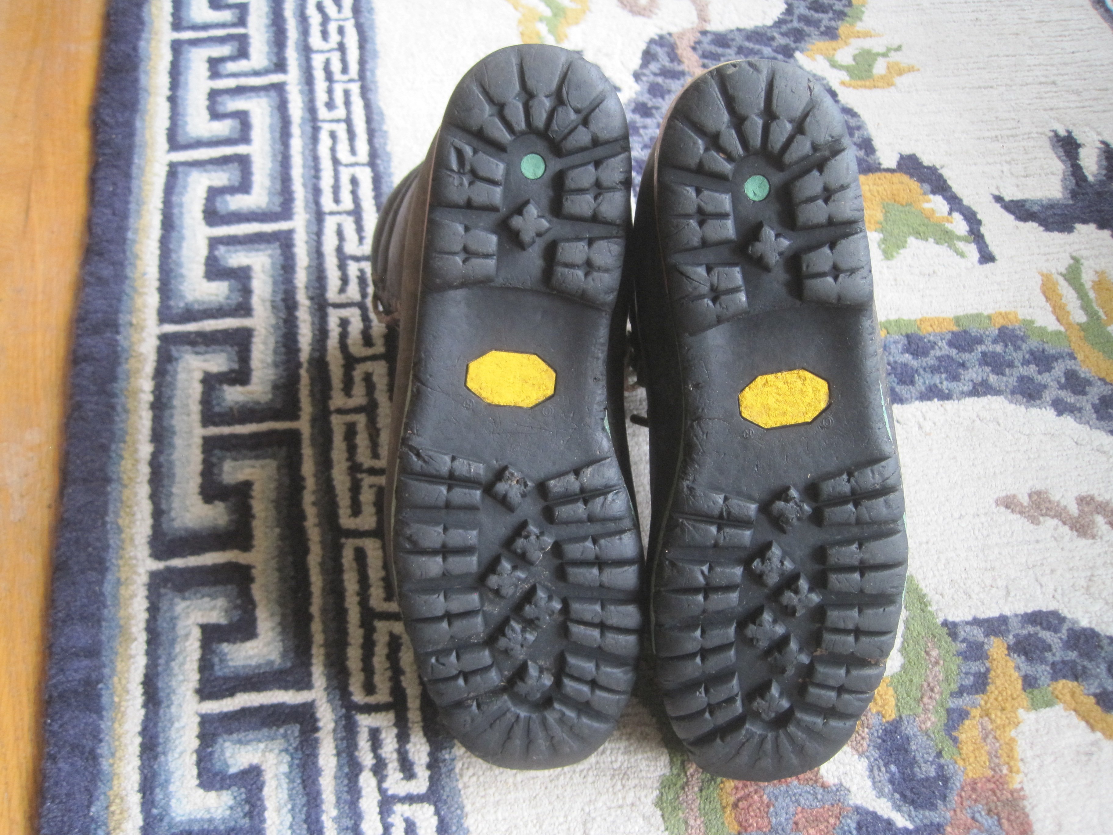
La Sportiva Nepals (circa early 2000's). Size 44. Uppers & interiors in good shape. Some damage to the front rands (glued). As with most rigid boots, the sole wear is at the toe & the mid-sole is worn to the point where you should really only use these with universal bindings on the front. Dave Page can do a standard resole but the mid-soles, necessary to restore them to use w/ wire front bales, are hard to source. $50 obo.
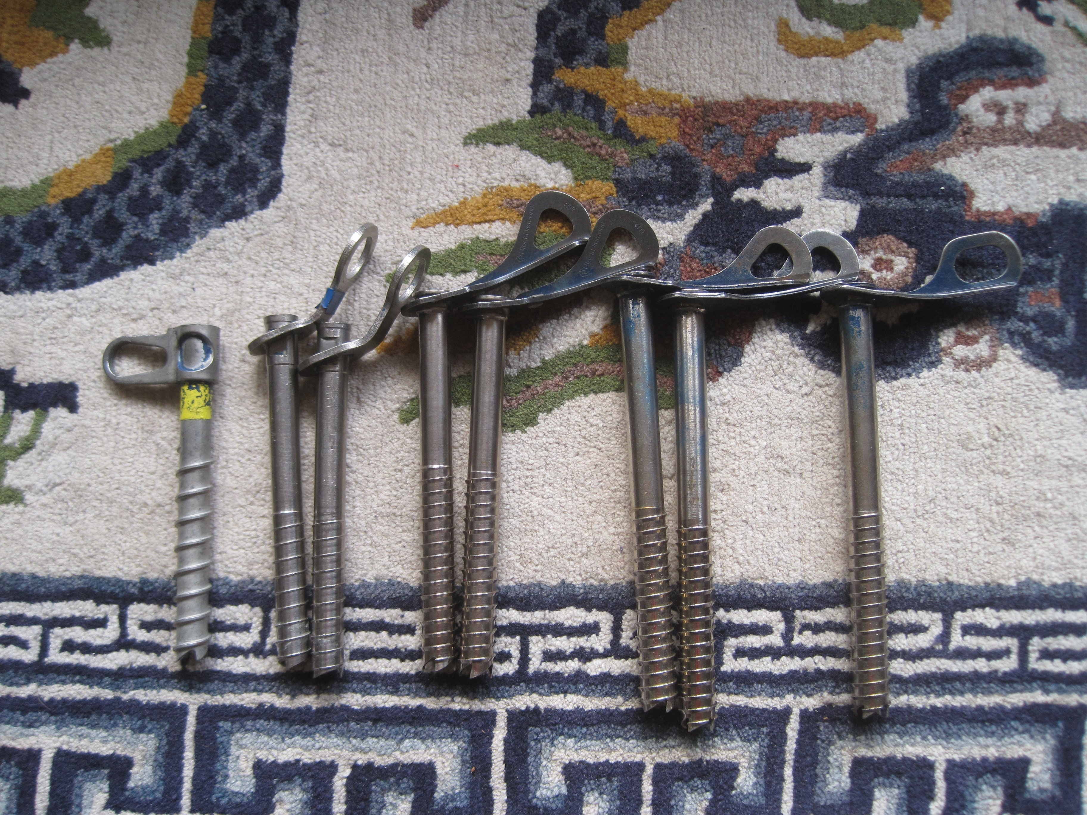
A mix of old screws:
A Chouinard 14cm (for those who remember the days of rapping off electrical conduit) & two 17cm To-Hell-With-Putin Specials -- free.
BD 2-18cm, 2-21cm $5 apiece. These need sharpening but are fine for that one long screw on your rack for the shit ice and/or v-threads.
Smiley 1-21cm. $5. As for the BDs but the hanger accepts 2 'biners.
Cash. I can meet anywhere from north Seattle to Sedro-Woolley.


-
Surprisingly, these have been claimed.
-
Ice Climbing Utah, 2000. Very good condition.
South Fork Water Ice, 1992. One of the earlier maps for Cody, WY. Pretty marked up & probably only of historical interest since everything is now in Winter Dance.
Skaha Rock Climbs, 1997 edition. Very good condition.
Escalada en Tenerife, 2019. Sport climbing in the Canary Islands. Pages coming out of the binding but still serviceable.
All free. I strongly prefer not having to go to the trouble of mailing these but might be convinced to do so. Can easily meet or drop them anywhere near I5 from north Seattle to Mt. Vernon/Sedro-Woolley area.
.JPG.840d7e0efc4514239ea94454638e576b.JPG)
-
Assuming you're somewhere in OR, the Cabinets sound like good adventure. Or there are a couple lines on the NE side of Wheeler Pk in NV.
The NE side of Pyramid Pk. in the N. Cascades also has a couple routes awaiting second ascents. Might be about the same drive/hike as A Pk. but shorter routes. Certainly less of an approach than Buck or Chiwawa unless you want to rent a snow machine. You might be able to drop into the head of Colonial Cr. from the same bivy & climb the west face of Colonial Pk. if time, energy, and travel conditions allow.
-
Margo,
Here is the link to the FA: https://cascadeclimbers.com/forum/topic/98132-tr-mt-triumph-new-route-on-east-face-memento-mori-aka-the-tom-thomas-memorial-route-9122015/?tab=comments#comment-1134986 Based on his response, Skeezix may be able to help you.
If you haven't seen it, here is the link to the accident report: http://publications.americanalpineclub.org/articles/13198907402/Fall-on-Rock-Climbing-Alone-Washington-North-Cascades-National-Park
Sorry to hear about Ken.
-
Sounds like someone should start a J'burg Epics thread....
-
I personally think that beer is a legitimate expense for running the site & part of our donation can be used for such if you wish.
-
1
-
-
Right on. Cool photos.
-
Michael,
You two made quick work of it. Glad you enjoyed it. I vaguely remember pulling some move pretty close to the belay just to avoid the left-right manuever. I don't remember the corner in your photo. I finished up a lighter colored corner that seemed like an relatively recent scar but the rock was good. As you found out, there is plenty of room for variations. Eric might have a better memory & chime in eventually.
Darin,
I've climbed a number of your routes and mostly enjoyed them. You really know how to slam in bolts for us hoi polloi... To my knowledge, you have climbed none of ours. You might like this one. Or Mox, which I maintain is as good as Bear's DNB but more committing. Cheers.
-
That's one reliable climbing partner you have there.
-
Normally I wouldn't shit on such a genteel parade but Eric's route photo needs a reality check.
Yellow dots show the initial foreshortened start. I slung a barely adequate horn & down climbed. My climbing ability & risk tolerance have declined so the corner above might go for someone else. This is a reasonably sheltered start for what could be an aesthetic line. I would still advise an emergency bolt kit for the rib above since there appear to be some large gaps between cracks/seams.
Red dots show our approx. line. The definition of poor communication (unsure on who's part): a partner who takes silence as acquiescence.
Gullies to the right/left of where we started are "maga" gullies. In contrast to Lani & Sam's "mega" gully on Whatcom Pk., "maga" gullies spew shit & idiocy. The left one did so while Eric was climbing the first pitch. After P2, Eric fortuitously declined to continue up the left hand rib & took us toward the right hand defile. Hindsight showed the left hand rib probably would have led to rotten rock above the tower in front of the summit tower, itself a massive rock scar with perched blocks. We fortunately avoided clocking one another or the rope while hugging the sides of the right defile. We escaped up the right hand rib as soon as possible.
In short, our route was an unaesthetic line on pretty crappy rock. Hopefully this info will help a future party put up a better line on the right hand rib.
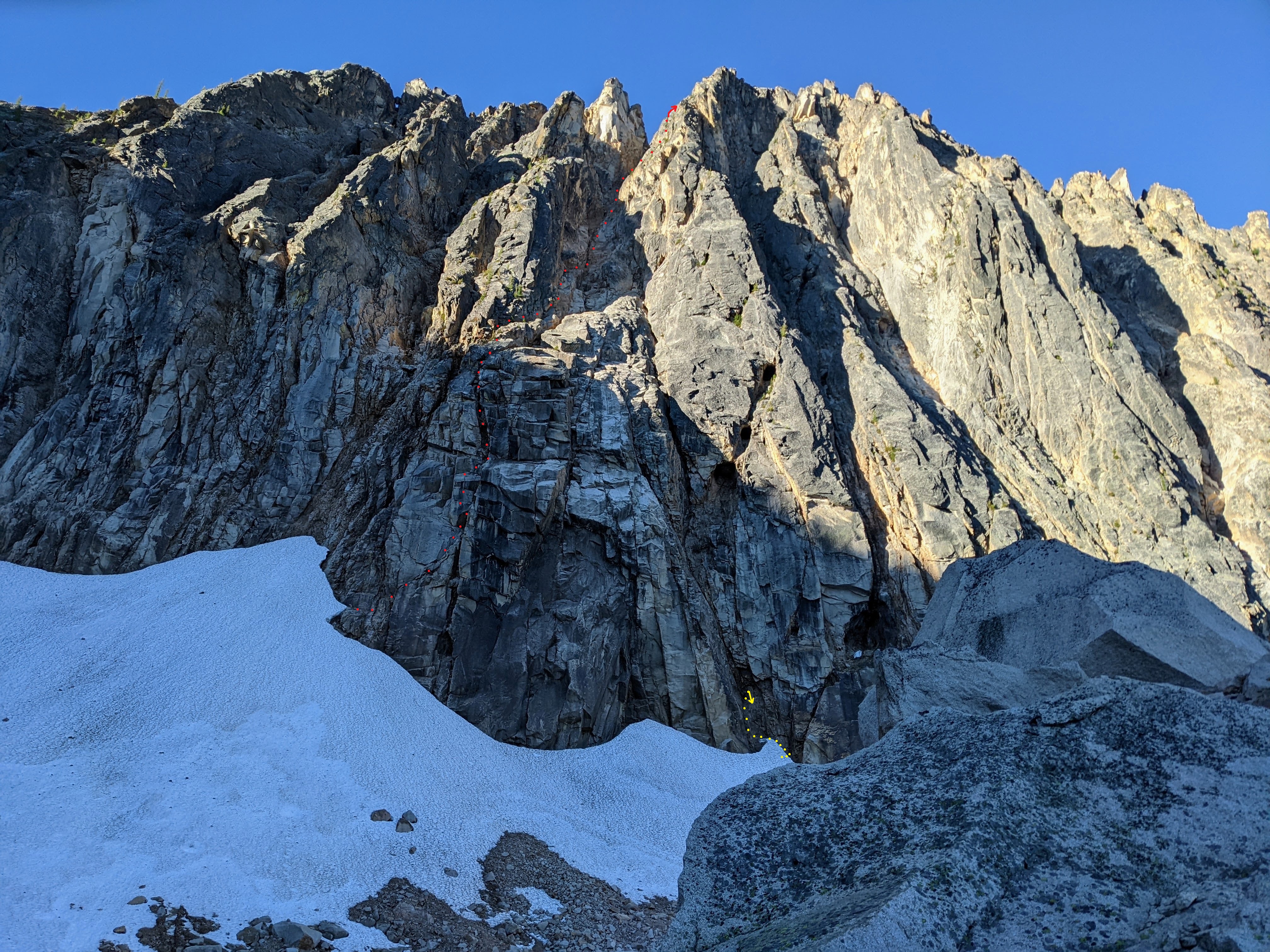
-
1
-
-
Nice job. Does your line take the buttress on the left in Matt's photo with your "mega gully" separating it from the slightly shorter but steeper buttress on the right? Thanks.
Baker area hut proposal
in Access Issues
Posted
Thanks for the takeaways tbickford. For those interested, the public comments are posted here:
https://cara.fs2c.usda.gov/Public//ReadingRoom?Project=65559