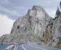
spotly Posted November 3, 2008 Posted November 3, 2008 This is just upstream from where the Sanpoil feeds into Lake Roosevelt. I've fished below it many times (great winter trout!) but have never thought to check it out up close. I think I'll head over there this weekend to see if there's an easy scramble to the top and check out the rock quality. An internet search found lots of historical information. Anyone here have any first-hand knowledge of it (access, rock quality,...)? Quote
Lithophiliac Posted November 3, 2008 Posted November 3, 2008 I worked as a biologist on Lake Roosevelt for several years in the 90's and was very interested in these formations as well. There are tons of potential routes all over that area on great rock, but I was always told that it is closed to any climbing (and even non-tribal access) due to it being on the Colville Indian Reservation. Same story with the outcrops across from Porcupine Bay on the Spokane arm (except these rocks are on the Spokane Indian Reservation). I never got a definitive answer from Tribal Authorities, but stayed away anyway. Anyone have more current info?? Quote
spotly Posted November 3, 2008 Author Posted November 3, 2008 The land on the east side at that point is part of the Colville Reservation but unless my map is wrong, the west side isn't. Part of the history of the rock is that the tribe that was there, refused to move onto the reservation until their leader was thrown into Alcatraz. I've never noticed that the bump to the west of Whitestone Rock is also labeled Whitestone. Quote
leearden Posted November 4, 2008 Posted November 4, 2008 I know of bolted routes on the Columbia's west side. They are between the 2-rivers casino, at the Columbia/Spokane confluence, and Hunters. They are accessed by boat and I understood there to be a few independent lines, still dirty having had little traffic. These routes aren't on White-Rock, but upstream. Quote
Lithophiliac Posted November 4, 2008 Posted November 4, 2008 Looking at your map, the left side is the tribal land which is where almost all of the good stone is. There is some stuff on the non-tribal side but not much and its not nearly as good as the other side of the river. You should check it out when they draw down the lake (winter), then everything from the 1280' line down is on Bureau of Rec. land I'm pretty sure. There's one crack line I dubbed Davey Jones' locker that would be a 5 star classic (were it not for all the algae slime on it) - very similar looking to Never Never Crack in Leavenworth. Quote
spotly Posted November 9, 2008 Author Posted November 9, 2008 A few of us scrambled up the west side of it today. The rock looked like crap from that side but I think I'll have to hop in the boat to see if the east side looks the same. A plan for next summer Quote


Recommended Posts
Join the conversation
You can post now and register later. If you have an account, sign in now to post with your account.