Search the Community
Showing results for tags 'glacier peak wilderness'.
Found 1 result
-
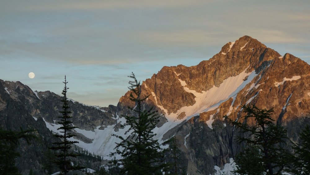
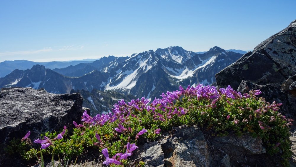
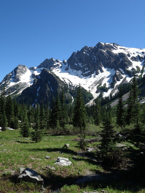
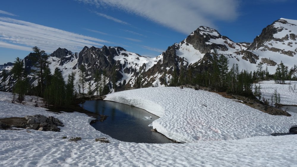
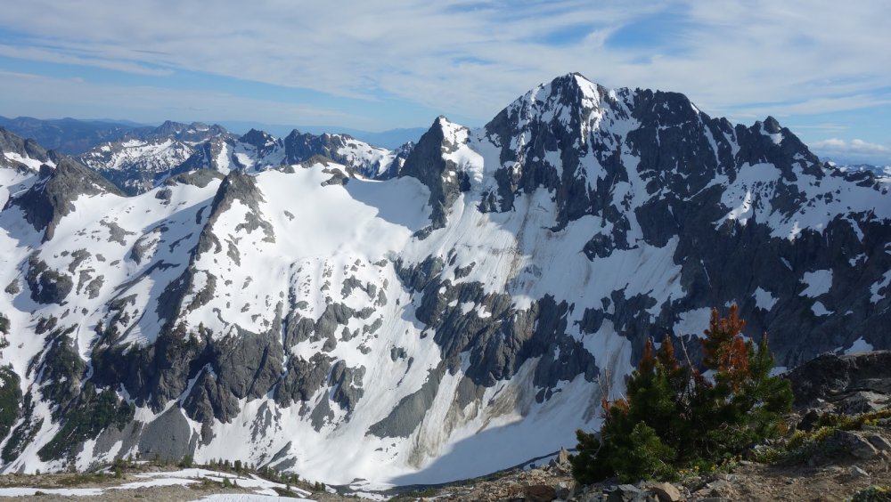
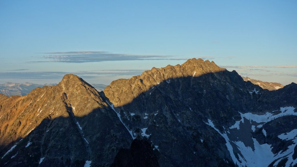
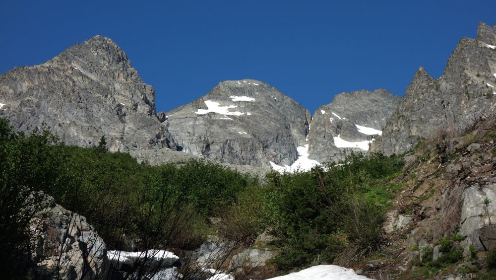
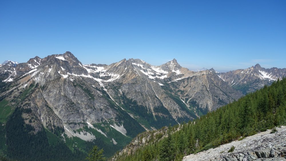
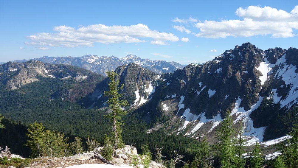
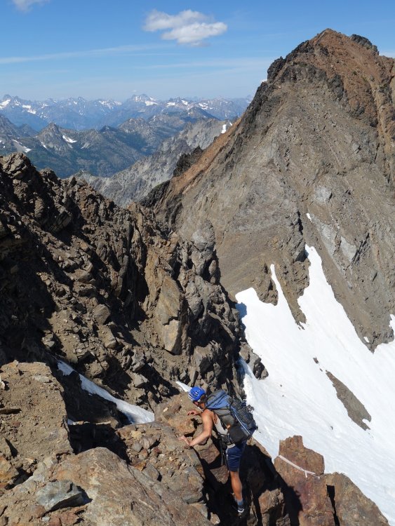
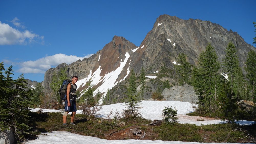
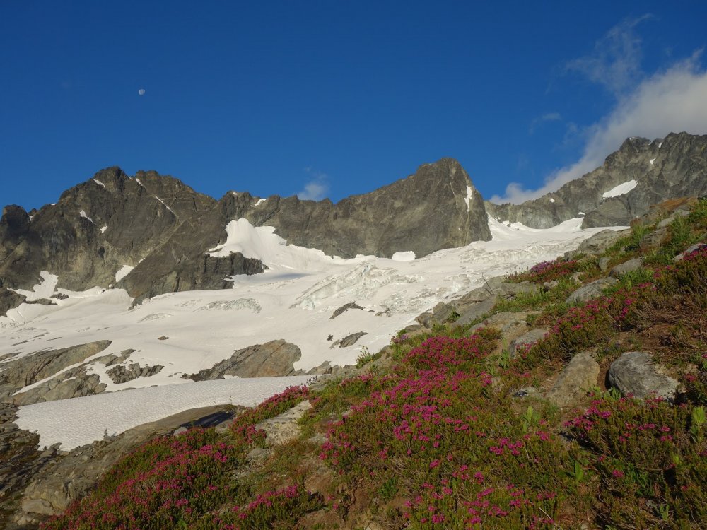
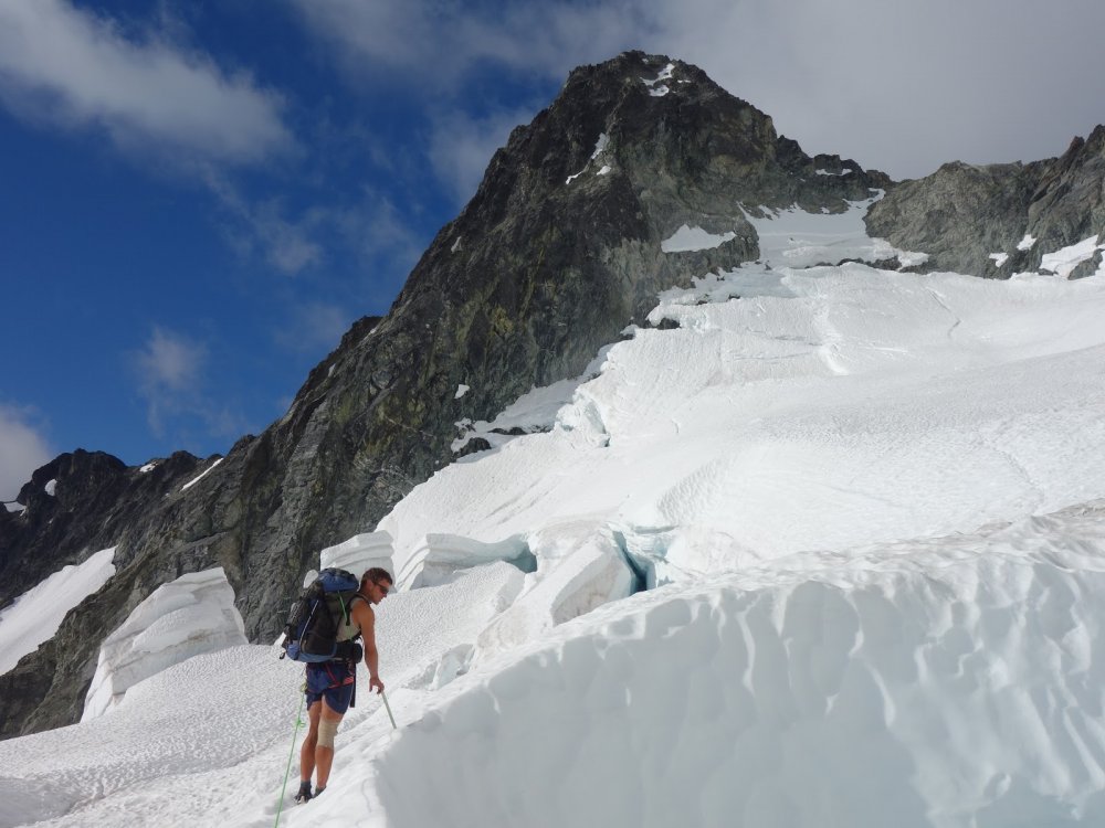
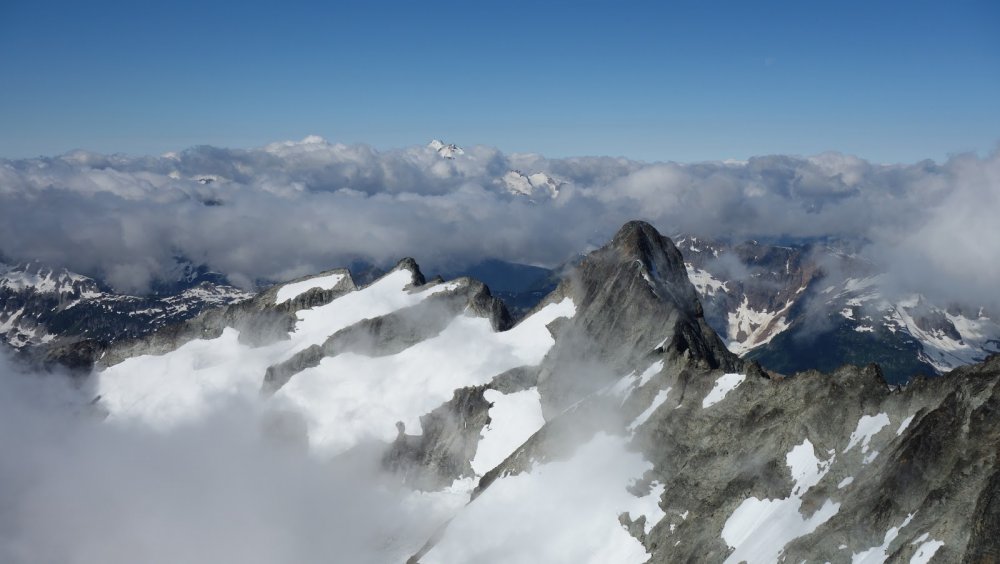
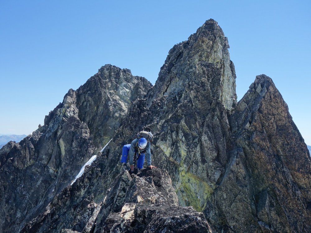
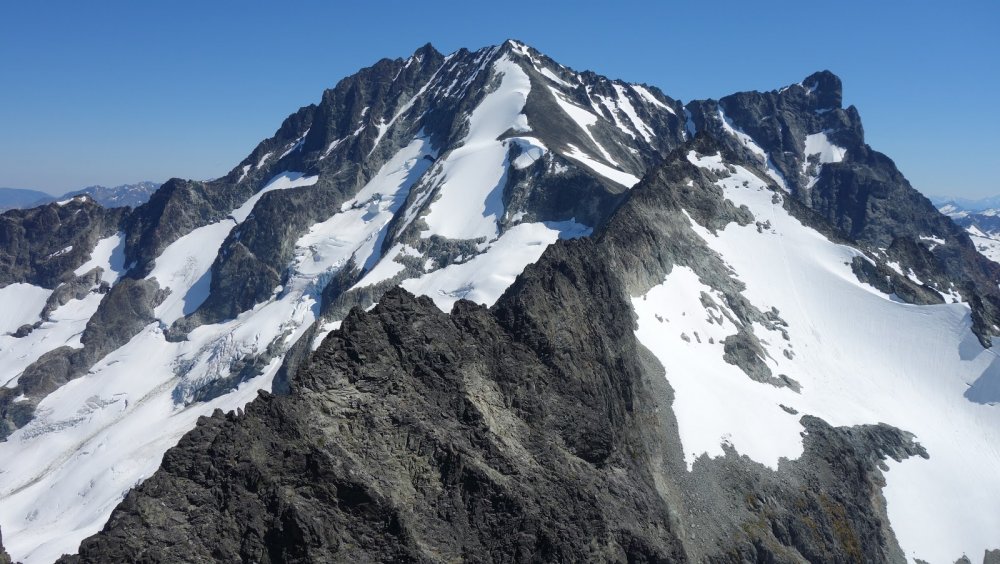
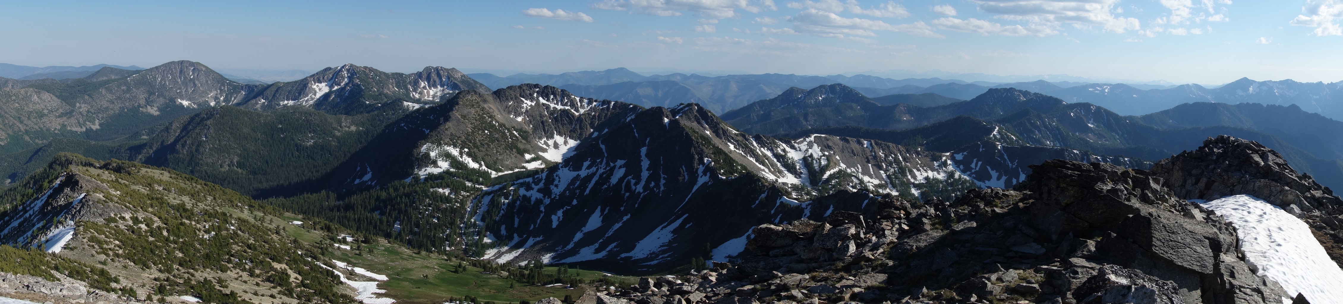
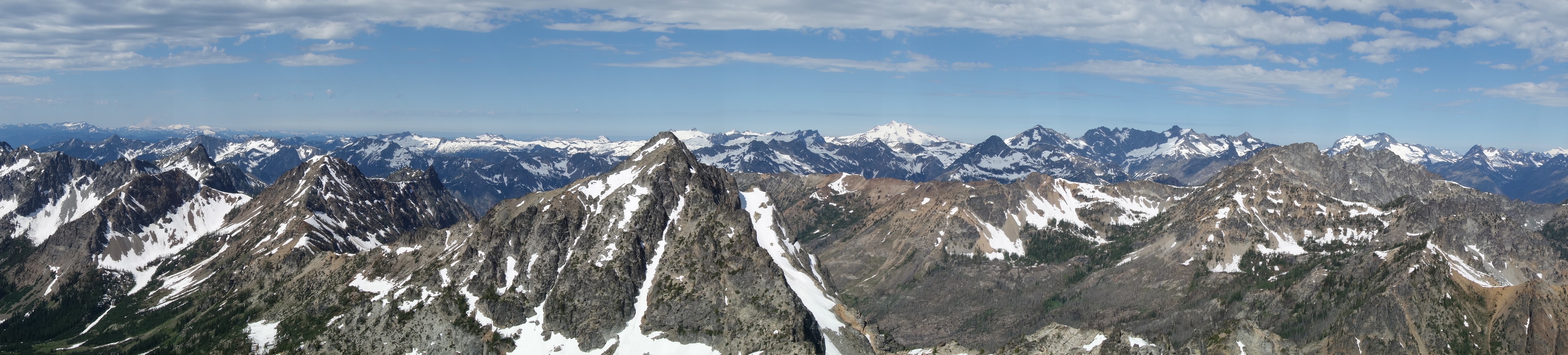
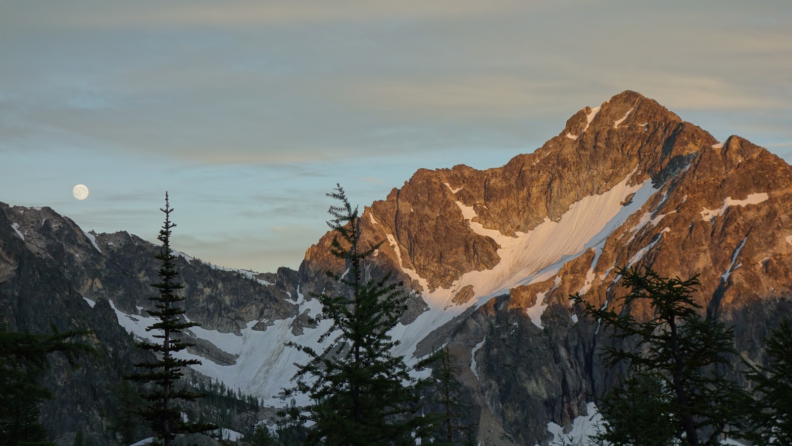
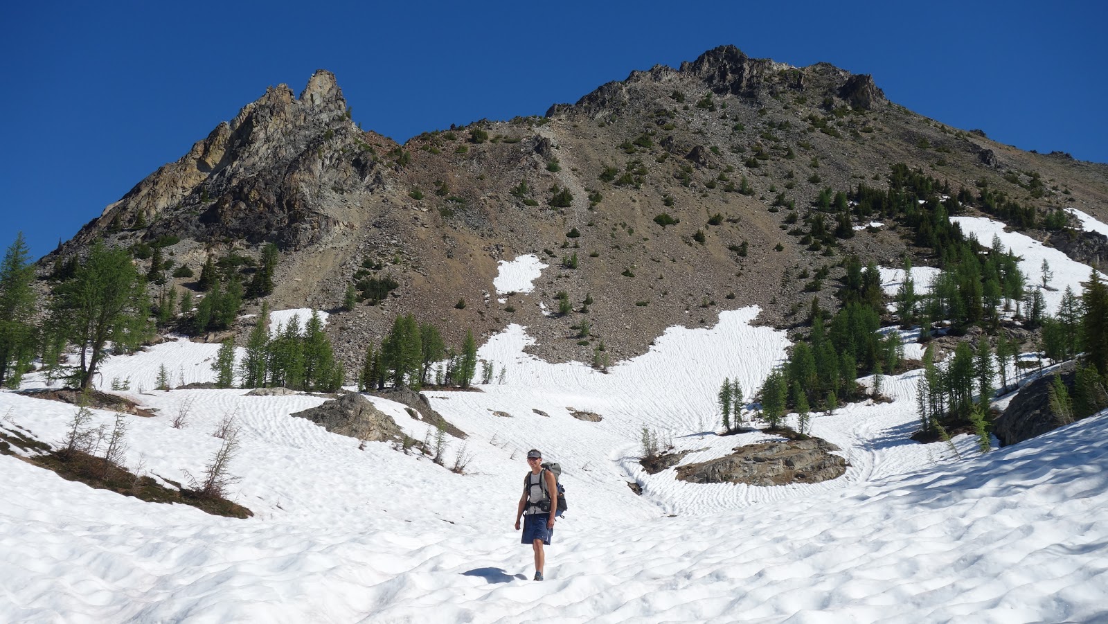
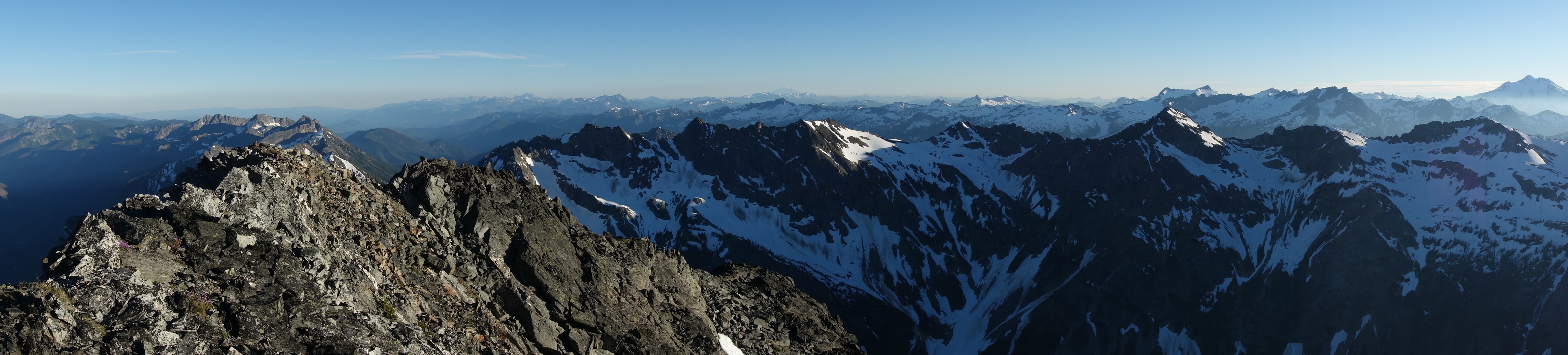
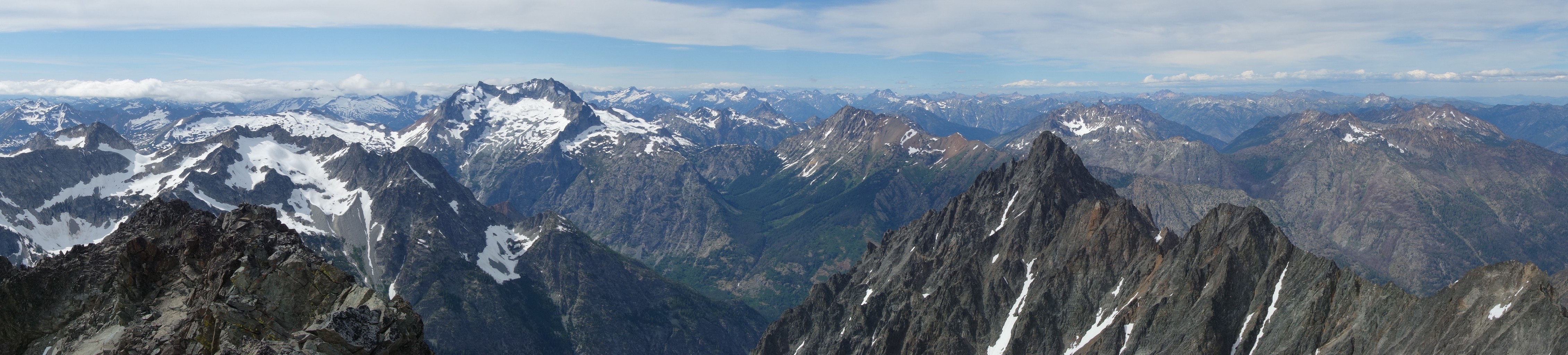
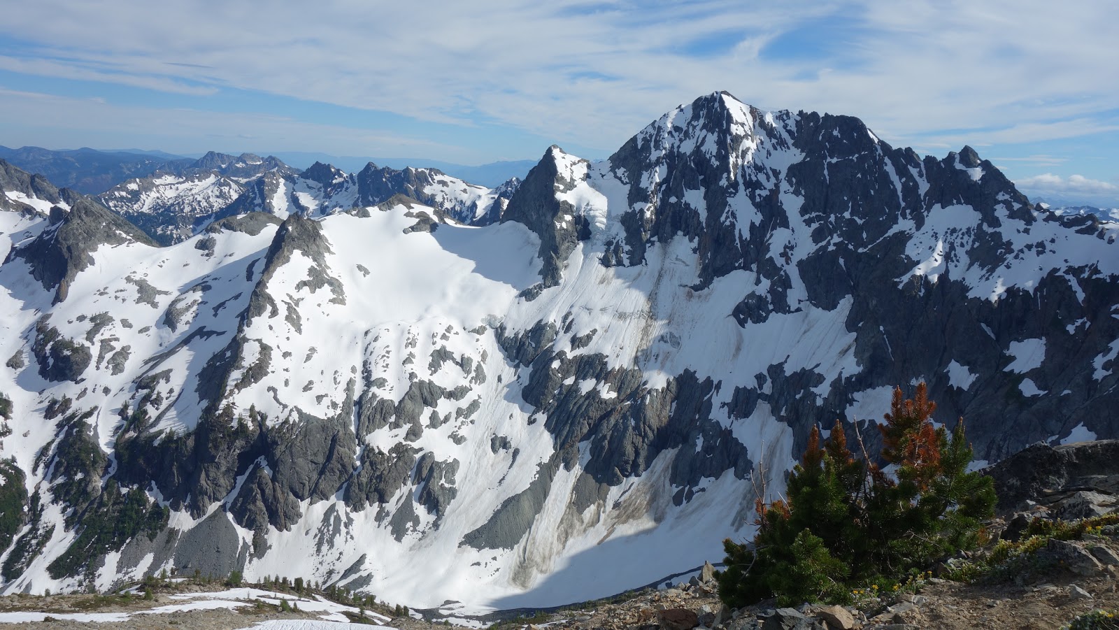
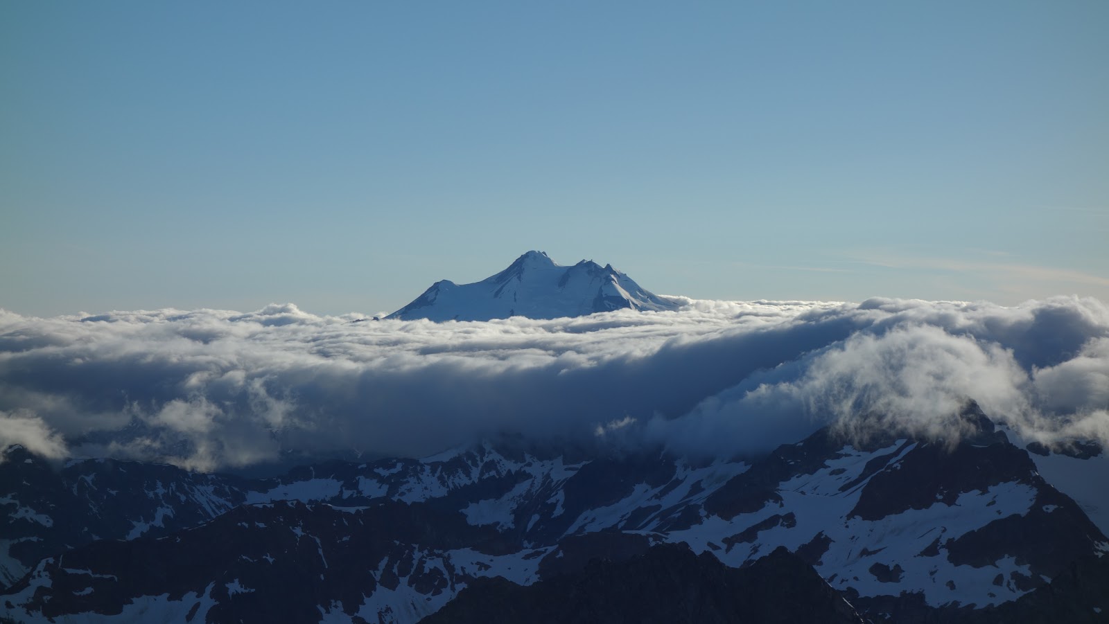
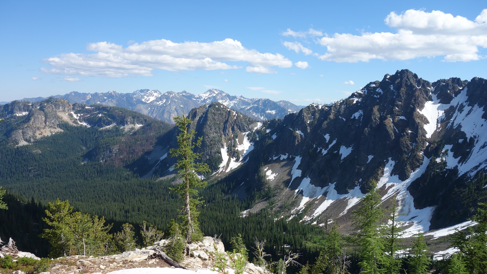
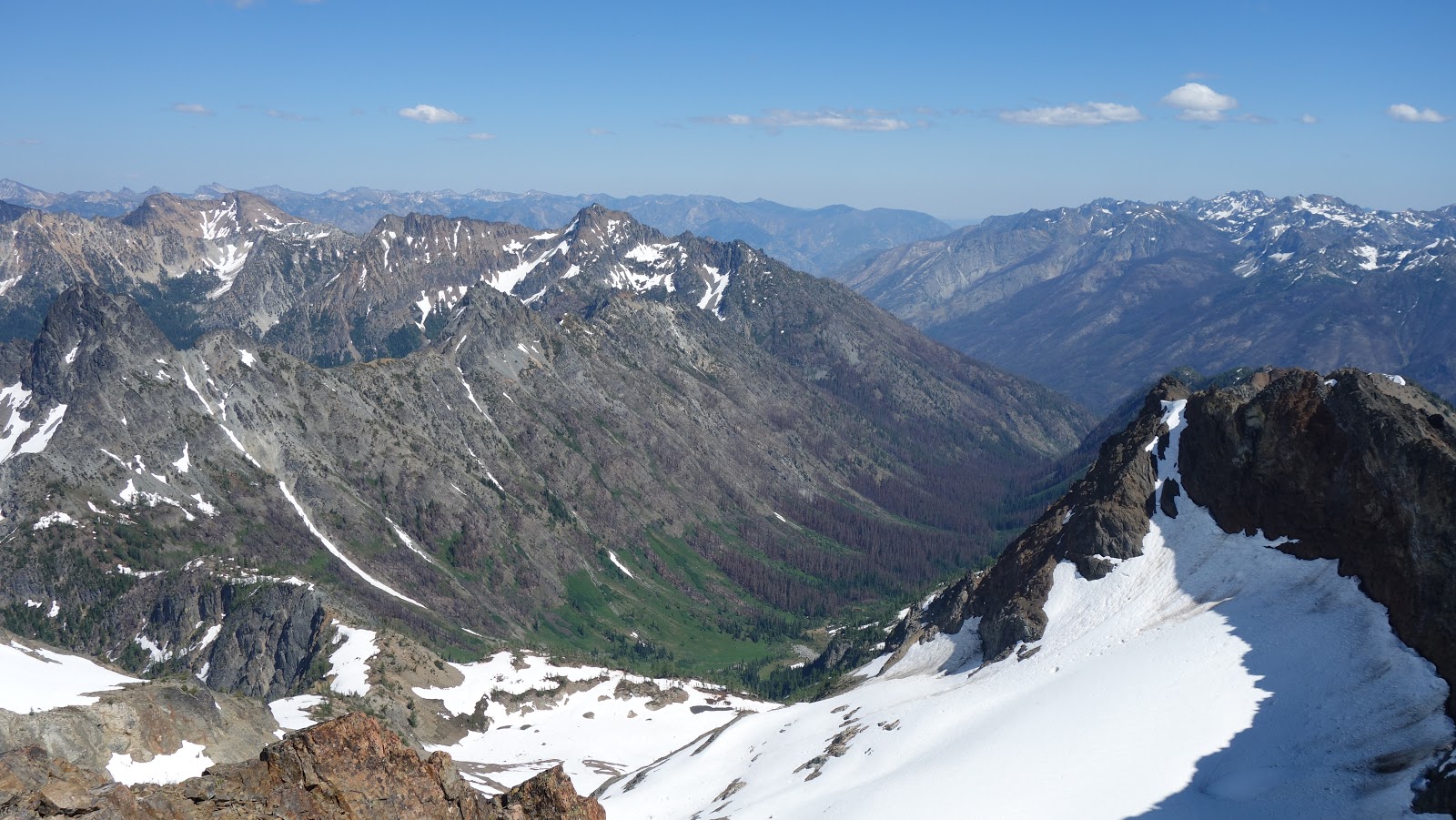
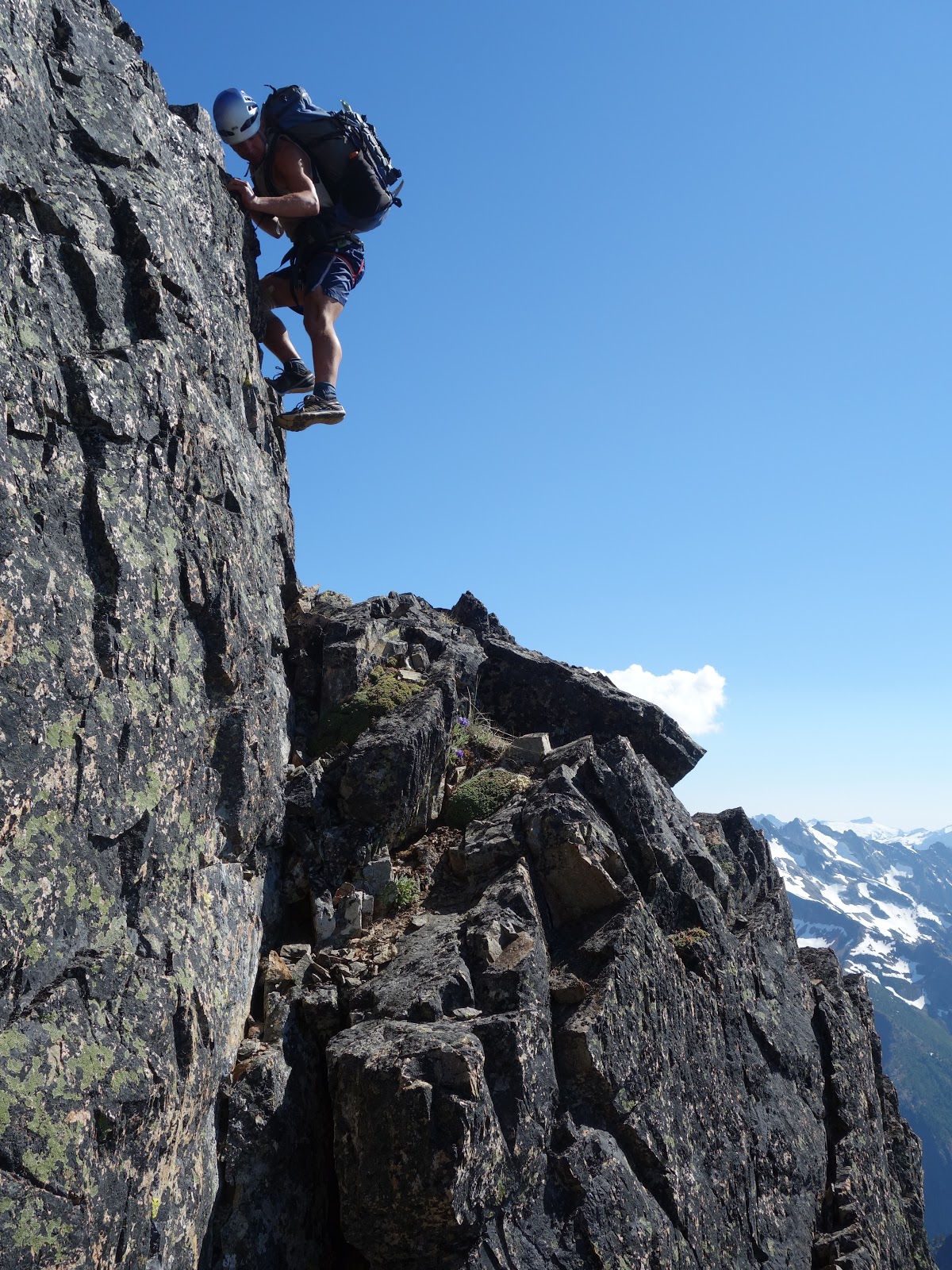
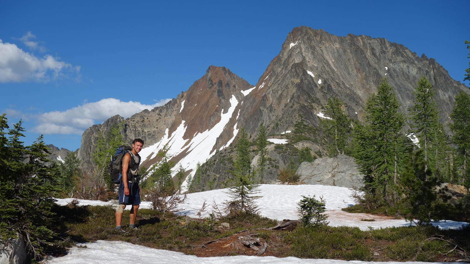
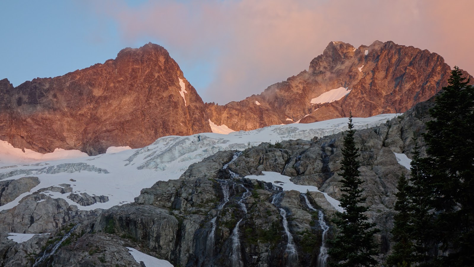
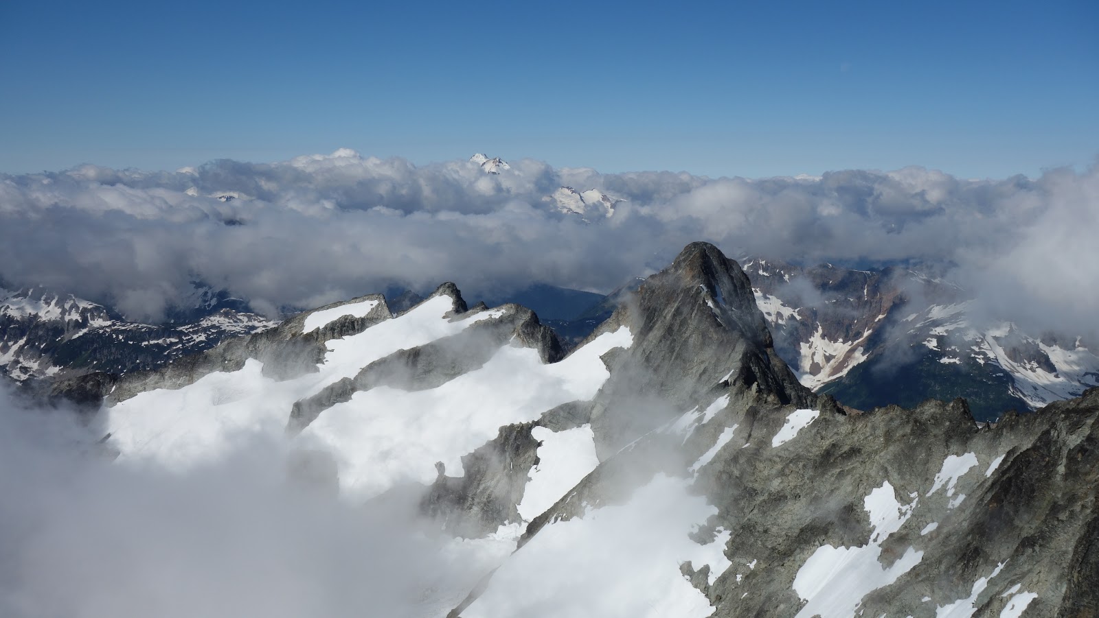
 Trip: Glacier Peak Wilderness Blast - 11 Bulgars - Date: 7/14/2017 Trip Report: For this 10 day trip, Josh joined me for an epic journey through most corners of the Glacier Peak Wilderness, with a planned route that josh envisioned to connect 11 Bulgar Peaks (12 for Josh since he hadn't done 7 Fingered Jack and I had), as well as a quick warm up day in the Chelan Sawtooths. This trip report will feature three parts, with this first installment depicting the first 4 days. Before beginning, I will give an overview of what we did for anyone looking for a condensed version of the whole trip. In order, we climbed: Warm up: Switchback Peak Martin Peak Cheops Main Event: Emerald Peak Cardinal Peak (and its South Peak) Saska Peak Unnamed Peak 8040+ Pinnacle Mountain South Spectacle Butte Seven Fingered Jack (Josh only) Mount Fernow Copper Peak Flora Mountain Martin Peak Bonanza Peak Dark Peak Linked below is a map of our route. Red is day 1 with the darker purple being day 9. Follow the rainbow color sequence, and click on the icons for additional info! Map July 5th Day 1 - After Josh and I celebrated the 4th, we took a leisurely morning and went food shopping, got gas, and drove to the Chelan Sawtooths, arriving at the Eagle Lakes Trailhead at 2pm. We hiked up Switchback Peak, then traversed over Martin and Cheops to Horsehead Pass and hiked back, returning to the car at dark. July 6th Day 2 - Took the Chelan ferry to Lucerne, Josh waited while I took the shuttle bus to Holden to stash half our food, rope, a few cams and slings at Holden to be picked up halfway through our trip. Returned on the bus back to Lucerne and began at 2:30pm, and hiked up the Domke Lake Trail. Trail was mostly fire destroyed from the lake onward the majority of the way to Emerald Park, making for a very hot, dusty hike. Camped shortly beyond Emerald Park. 8 miles & 4,900 feet gain July 7th Day 3 - Finished hike to Milham Pass, dropped packs and climbed Emerald Peak, Cardinal Peak, and since I couldn't tell which peak on Cardinal was higher, I traversed over to the South Summit as well. This included a short 5.7 overhang I solod. The register on South Summit had been there since the fifties. Josh had to hold my feet for me to downclimb the short crux then we crossed the valley and climbed the SE ridge of Saska, and utilized a key ledge to quickly return to the Emerald/Saska saddle and back to Milham Pass. Grabbed our packs, and camped in the unnamed basin just NW of Milham Pass. 8.5 miles & 7,000 feet gain July 8th Day 4 - Hiked to a small saddle directly east of Pinnacle, and traversed over Point 8,040+ and around to Pinnacle Mountain, with much side-hilling on loose rock. Descended to the Entiat River (Borelis Pass Trail 100% destroyed) and forded the river utilizing a logjam for most of the crossing. Followed the Ice Lakes Trail, which was destroyed until it crossed to the creeks' south side at 4800 feet, at which point it was mostly usable. Left trail when the creek opened up into a boulderfield, and hiked into the basin west of South Spectacle Butte. ropped packs at 6600 feet and went to the pass between North and South Spectacle and attempted the NW ridge. This was a mistake as a hidden gendarme with large drop blocked passage. Josh recalled the standard route was the SW ridge, so we dropped a steep loose gully to the snow and traversed over to the standard route and scrambled to the summit, topping out at 8pm. Returned to our packs and camped at Lower Ice Lake. 12 miles & 6,600 feet gain July 9th Day 5 - Hiked past Upper Ice Lake (both of which were still frozen) and traversed into Leroy Basin and around Maude and 7FJ. Josh convinced me to let him run up 7FJ real quick while I waited an hour and a half at the 7,600 foot pass enroute to Fernow. He ran up the west slopes and met the standard south ridge while I enjoyed the views. We joined back up and descended past the small tarn and ascended Fernow, meeting up with Tom S, Josh H and Luke S who had just returned from Copper, and were packing up their bivy at about 8300 feet. Their tracks helped a lot, and the whiskey Tom offered us reduced our pain (although gave Josh a buzz)! We packed over Fernow, then descended the glacier on its NE flank, crossed the key 7200 foot saddle and into the basin East of Copper. We dropped packs at 7500 feet and ascended Copper on steep snow slopes which took us to the upper NE ridge, which was an incredible scramble, especially with the improving late afternoon lighting. We topped out at 7:30pm, returned quickly yo our packs (thanks for the steps Tom!) and camped on a somewhat flay knoll at 5800 feet in Copper Basin. 9.5 miles & 6,900 feet gain July 10th Day 6 - Finished descending Copper Basin to Holden, with a bit of bushwhacking to traverse rightwards to meet with the Copper Basin Trail. Reached Holden and ate a shitton of food which included milk, cereal, sandwiches, fresh fruit, muffins, salad, soup, ice cream etc. Rested 4 hours in Holden, organized out gear cache and continued up the Tenmile Creek Trail and camped in the burned forest at the base of the slope leading to Tenmile Pass. 5.5 miles & 2,200 feet gain (Rest Day!) July 11th Day 7 - With day packs, ascended over Tenmile Pass (trail destroyed) and met the good Devore Creek Trail on the other side. Descended nice switchbacks to 5250 feet and crossed Devore Creek on a log, and bushwhacked into the basin north of East Riddler Peak. Reached the 7100 foot saddle and scrambled the mostly open ridge to Flora, except for traversing the snow slopes north of Point 7670 to bypass it's time consuming ridges. Returned to same camp in the Tenmile Creek Valley. 12.5 miles & 7,700 feet gain July 12th Day 8 - Packed up the remainder of Tenmile Creek and found the trail in the meadows below Hilgard Pass. Switchbacked up to the pass, then hiked west over the small hill to the unnamed glacier on the east flank of Martin Peak. Went to the 8000 foot saddle just north of Martin Peak and "scrambled" up the NE face which went at very, very loose Class 4. We had to use extreme caution to avoid dislodging microwave size boulders on one another. We then descended the west ridge to Holden Pass to camp, which we reached at a leisurely 5pm, enabling an earlier bedtime. 5.5 miles & 4,000 feet gain July 13th Day 9 - Woke up earlier than any other day at 5am, and climbed the Mary Green Glacier Route up Bonanza, which went smoothly. Topped out just before 9am with some marine layer clouds providing a nice change to the hot cloudless days we had every day since.Enjoyed the summit for 45 minutes and began the traverse west to the sub-summit, which involved a short 15 meter rappel, and some serious traversing on unstable ledges, one of which exploded under Josh, and he took a small pendulum fall following me, injuring his fingers when rocks came down. Luckily he was ok, and was able to bandage his fingers up and continue. We did a total of 2 roped traverse pitches until the rock quality increased and scrambling difficulty relented a little. We then were able to both solo scramble the entire traverse to Dark peak, staying right on the wildly exposed ridge crest the majority of the way, deviating on ledges only twice. Once shortly before Dark Peak to bypass a large notch and a second to pass below a couple small gendarmes. At about 3pm we reached Dark Peak, the final peak of our trip and celebrated on the summit with a nice break, since we were both mentally exhausted from dealing with so much exposure for that many hours. We ran down the Dark Glacier to the small swampy meadow at 5000 feet, at which point my worst nightmare came true. There was no trail of any kind descending Swamp Creek. See part 3 of this installment for more details, but we found a place to camp at about 3800 feet right as it got dark, which capped a 16 hour day. 7 miles & 4,200 feet gain July 14th Day 10 - Finished the now more manageable bushwhack down Swamp Creek and met the Agnes Creek Trail (PCT) and hiked 6 miles out to High Bridge, where we caught the shuttle bus to Stehekin, and the ferry back to Chelan. Jumped in the lake to clean off, and ate 2 beers, 2 pizzas and 2 ice creams myself in Chelan. 10 miles & 800 feet gain Trip totals: 78.5 miles & 44,300 feet gain, plus the distance and gain for our warm up day which isn't included here Detailed Report: July 5th Day 1 I ended up meeting up with Josh at his place for some fireworks for the 4th of July, since I took the day off from climbing. I had just returned from an awesome climb of the SW buttress of Cathedral Peak and the nearby scrambles, and a day of climbing in Squamish and needed a day off, so I helped my dad finish the new deck he is building at home and rested. In the evening, I drove from Renton up to Lynnwood to meet Josh and have some beers and watched fireworks, as his brothers had a full array of stuff to display. I crashed the night at his place and we drove out to the Chelan Sawtooth Range the next morning, after some grocery shopping. We realized we didn't want to wake up at 4am to try and catch the Chelan Ferry at 8, so we pushed the full Glacier Peak Wilderness trip back a day and decided to warm up by hiking Switchback, Martin and Cheops, the last 3 major peaks I had to still climb in the Chelan Sawtooths. So we drove all the way to the Eagle Lakes Trailhead at 4700 feet and started hiked the 7 miles to Cooney Lake at 2pm. It was a nice walk on a gentle trail all the way to the lake, that featured just one small creek crossing. Since the snow was pretty much gone throughout the Sawtooths, we wore light tennis shoes, and just carried water and a few snacks in one day pack between us. We made quick work hiking around the north side of Cooney Lake and hit the Switchback/Martin saddle and dropped the day pack to run up the final 400 feet of east Class 1-2 to Switchback Peak. From there we were able to see the Saska Group and many of the peaks we were about the embark on. It was still well over 70 degrees on the summit at 4:30pm without any clouds or wind. We then continued on the easy ridge up the the small sub-summit, at which point some Class 2+ scrambling began. We passed through a small notch and topped out on Martin Peak as the sun began to dip a little lower in the western sky. We didn't stay long because we decided we had time to traverse over Cheops as well and hike out the other trail via Horsehead Pass. Scrambling over Cheops involved a lot of Class 3, and with the route variations we took we found some nice Class 4. The ridge was quite nice with many solid spots. By 8ish we topped out on Cheops and descended the long, sinuous ridge to Horsehead Pass. As we began hiking down the Eagle Lakes Trail, the sun was beginning to set, and Cheops was lit in a bright orange glow. Shortly below the turnoff for the Upper Eagle Lake, we passed the large group of backpackers we ran into at the trailhead. Comparing their pack sizes to our 3 pound combined day pack was pretty hilarious. 30 minutes after it was pitch dark we reached the car, and managed to find an open gas station for dinner. We crashed off a FS road near Chelan and set a 6am alarm so we could get to the ferry dock in time to buy tickets. July 6th Day 2 We woke up right at 6am and began organizing our food and putting it in bags, and packing up our gear cache to be left in Holden. We got our ferry tickets, and got a return ticket for July 15th, one day later than our planned time of departure to have a day buffer in case something came up. At 8:00 we took off on the slow boat for Lucerne, which we arrived at around 10:30. I got on the shuttle bus up to Holden with our gear cache, while Josh waited at Lucerne and took a nap. I had Emailed the registrar at Holden to ask if it was ok to leave a gear cache there, which they gladly allowed, and even held it safe for us! So upon arriving I was able to simply drop it off in a safe storage spot that I could access after hours in case we were too early or late. I grabbed a quick bite to eat and some ice cream before taking the bus back to Lucerne with the visitors that were leaving that day. At 2pm, Josh and I began hiking, from a measly low 1,200 feet elevation on the shores of Lake Chelan, in temperatures around 90 degrees, with our full 30 pound packs! Eek Initially, the hiking was going well; we found the bridge over Railroad Creek, and located the start of the Domke Lake Trail and hiked the nice switchbacks up. Despite the entire region being devastated by the Wolvering fire in 2015, the trail was in good condition. We were sweating buckets however and exhausted our water bottles before reaching the junction for the Milham Pass Trail. When we reached this junction, we got our first realization that the nice trails Josh had promised may not be that nice after all. We turned right at the junction, and began following the very faint trail around and above the west side of Domke Lake. It didn't take us long however to lose it entirely, and despite Josh having the trail marked on the GPS, it was impossible to find, and we determined it was completely destroyed by the fires after we could find it for two hours of criss crossing it up and down. We gave up on the trail and continued plowing our way through the ash, down trees, and the occasional sinkhole from tree roots being burned out. It was a hot, tedious hike southward towards the creek descending from Milham Pass. In hindsight, we should have just hiked along the lake shore if we knew the trail was gone, because the side-hilling was annoying. We finally reached the creek however, and dropped 100 feet to fill up our water bottles and chug a couple liters. From that point we continued up the steep slopes, off trail until we eventually found the trail again around 3,500 feet elevation! As we got higher, it was just barely discernible much of the way, albeit way overgrown. This saved us a lot of time though, and we were able to follow it to where we reached unburned forest at 4900 feet. Here the trail was easy to follow, but still overgrown. We reached the beautiful Emerald Park around 8:30pm, but it was way too buggy to stay long, so we snapped a few photos of the large meadow and continued another 20 minutes or so to a nice spot at 5550 feet right where the trail made a sharp right turn to ascend to Milham Pass. We camped here and put up the tent as the sun was setting. July 7th Day 3 By 7am the next morning we were on our way up the now great trail to Milham Pass. It was nice to have the switchbacks, and an hour or so later we reached the 6700 foot pass where we hung our packs on a tree and threw some things in our day pack. The goal for the day was to climb Emerald, Cardinal and Saska Peak. We agreed to alternate carrying the day pack throughout the trip, when we didn't have to carry our full packs. We traversed more or less horizontally south towards the basin below unnamed Lake 7230. Some steep class 2 took us to this lake which was still snow covered, and easy snow slopes led to a Class 4 rock step to reach the 7590 foot saddle between Emerald and Saska Peaks. We decided to do Emerald and Cardinal first, then cross back over to finish on Saska, so we began scrambling the ridge east towards Emerald. We deviated from the crest to its south To save time and avoid Class 4 terrain, eventually reaching a gully that looked like it would lead to the summit. I climbed a solid rock rib just left of the gully to avoid loose rock. Luckily we guessed the right gully and we reached the summit area, and scrambled the final few feet to the top. Our first summit was in the books! The wind was still whipping a bit, and it was certainly cooler than the first day which was nice. After a quick snack, and gazing over at the Chelan Sawtooths, we descended a gully further south and descended some class 4 steps to reach the slopes below the rugged cliffs guarding Emeralds' south ridge. We reached a low spot of 7300 feet before entering the open snow covered basin on the northwest side of Cardinal Peak. We were able to hike up moderate snow directly to the summit ridge and scramble the exposed ridge section to the top. To my dismay, I looked to the south and saw a second summit that looked potentially higher, or at least the same elevation. I told Josh i was going to go check it out so I traversed over to it, which involved a bit of Class 3 and a traverse in a moat. When I reached the base of the summit rocks, I completely circumvented it looking for a 4th or low 5th class route but the easiest place to climb looked like a 5.7 overhang. Since it was only 20 more feet I went for it, and climbed up the two moves (which required me to stem my feet on some small ledges and pull myself up). After topping out, I immediately regretted it since I knew I wouldn't be able to downclimb that unassisted, so I called Josh to traverse over and assist me a little. As he worked his way over I looked in the summit register, which was placed in 1965 and featured only a handful of parties! Apparently the south peak is indeed lower, if only by a few feet, but it was well worth the trip over. I signed it, and Josh made it over. He scrambled up to the big ledge at the base of the 5.7 overhang, and guided/held my feet, while I made the two critical hand movements (luckily they were mostly jugs) to lower myself down. From that point we returned to the main summit, and ran down/glissaded the snow slopes and descended into the 7000 foot level in the valley. I almost lost my phone on the glissade, which I was luckily able to find by hiking back up just a few minutes. We crossed the valley, filled our water bottles in the creek, and began ascending the SE ridge of Saska. By this point the 1400 more feet back up after coming down off Cardinal took a little time to get my legs going again. We were able to stay mostly on Class 2 terrain on the ridge and reached the summit mid afternoon time with more sun and less wind. As we ascended Saska, we saw a fighter jet whiz by and down the valley, which is apparently a common thing in the GPW. We descended the SE ridge to 7700 feet where I earlier noticed a nice ledge that would dump us much closer to the Emerald/Saska saddle allowing us to cut right below the east face and avoid extra elevation loss. We were able to traverse easy snow and reach a low point of only 7400 feet and regain only about 200 feet to reach the saddle again, at which point we made quick work down the snow past the small tarn and back to Milham Pass. Since we had some daylight left, and there was no water at the pass, we agreed to continue into the small basin off to the northwest, and set up camp at 7200 feet on a grassy knoll among beautiful slabs with an awesome view of Saska for the sunset. July 8th Day 4 We had a fairly long day doing 3 Bulgars in one day, but that would pale in comparison to this day. We woke up and quickly got going, ascending easy slopes to a small 7600 foot saddle directly east and across from Pinnacle Mountain. I realized we would have to traverse al the way around to get to Pinnacle, which involved us climbing up and over Unnamed Point 8040+ which definitely was class 4 the way we went. I had no idea if the other side would go, and even from the summit of this small peak it wasn't discernible. I spotted a hideous loose gully though and started down it, and amazingly it went! We were able to drop onto the loose south facing slopes opposite the ridge heading the Mirror Lake Valley. Lots of hideous side-hill traversing on ball bearing scree underlain by hard pan dirt ensued which surely ate up lots of our energy, but we eventually got to the 7850 foot saddle just south of the summit of Pinnacle Mountain. From that point we ditched packs and ran up the slopes to the summit. We were able to see the Unnamed peak we stood upon earlier that morning and its imposing west facing cliffs, as well as South Spectacle Butte Across the Entiat River Valley; our next objective for the day. We descended back to the packs, took a snack break and began descending easy snow towards the Borelis Pass Trail, which we would soon determine also no longer exists! When we reached where the GPS said it would be located, nothing even resembling a trail was visible. Luckily the area was very open and cross country walking was easy so we just made a bee line descent on the path of least resistance in the general direction of where we needed to go. It was slightly over a 4000 foot descent to the Entiat River, and the ash covered ground and downed trees got worse the lower we went. When we finally reached the Entiat River Trail, it was barely visible under the 100s of fallen trees. It took us a solid 15 minutes to just reach the river. We located a nice logjam that allowed us to cross most of the rapidly flowing river but for the final few steps we had to remove our shoes and wade in knee deep water. There we tried to locate the Ice Lakes Trail, but amidst the total devastation of the forest throughout the entire Entiat Valley, we couldn't find it either. I was beginning to get rather annoyed with constantly climbing over downed trees and being exposed to the hot sun in all the burned forests, and was thinking how sad it was that the entire regions' forests were destroyed. It would take years to clear and rebuild all the trails! We were able to more or less follow the path of least resistance around, and into the Icy Creek Valley, where we passed an exceptionally bad section of burn, where literally everything was reduced to ash, and no logs or roots were found on the ground. This part was exceptionally hot and dusty. Beyond that, we crawled over more logs, and often would string them together and walk on top of them at times connecting 5-10 different logs! This proved easier than walking on the soft ground as well. Somewhere around 4700 feet we entered healthy forest once again and was able to follow the trail, cross Icy Creek twice (first time had to wade, second time the old log bridge was still intact), and reach the big opening in the creek at 5600 feet. Rather than ascend the boulders along the creek as one would do to go directly to Ice lakes, we turned right and ascended the steep tree covered slope heading eastward towards the basin below the west face of South Spectacle Butte. At 6600 feet we ditched the packs and headed for the saddle between North and South Spectacle Buttes. I had envisioned us climbing the NW ridge based on simply what I saw from upper Ice lake 10 days prior. From there it looked like the NW ridge was an easy scramble. Josh only had word from Adam that the SW ridge was the standard route, but I for some reason thought that was a bad idea since I saw numerous deep notches in that ridge. We ascended to the 7300 foot saddle between the two peaks and began up class 2 talus until we reached an impassible notch and gendarme I couldn't see until I was right on top of it! Baffled as to why I couldn't see this from Upper Ice Lake, I begrudgingly admitted Josh was right and we descended a loose gully back into the small basin and traversed snow over towards the SW ridge, and climbed a steep snow gully to meet it at 7400 feet, making the detour only having done an extra 700 feet. Once on the SW ridge the notches I saw from the basin were actually easily passed on the south side of the ridge crest, and the so called Class 4 ledge traverse crux was only Class 3 in my opinion, and quite simple. We topped out shortly before 8pm and enjoyed the view of Maude and 7FJ the most. Ice Lakes below us were still frozen but this wasn't a surprise to us. We didn't stay long though as I really did not want to be on that ridge after dark, and I ideally wanted to get to Lower Ice Lake before needing headlamps. So we quickly scrambled down the ridge and ran down the snow to our packs and made quick work of the traverse to Lower Ice Lake where we stumbled upon a perfect camp spot right as it got dark, complete with flatness, devoid of rocks, roots and sticks, and very close to running water! We were moving for 15 hours, and managed to get both Pinnacle and South Spectacle Butte in the same day with two unplanned detours. I was amazed, and remember commenting to Josh i hope all the days are not this long haha! July 9th Day 5 After the long day climbing both Pinnacle Mountain and South Spectacle Butte, we got a decently early start from Lower Ice Lake and hiked past the upper lake and over the 7550 foot saddle and crossed into upper Leroy Basin. We decided to descend and stay as close to the lower western shoulder of Maude as possible, and managed to only drop to 6400 feet, before starting an ascending traverse around the west side of 7FJ. Josh was pitching his case for me to let him quickly run up 7FJ but I was leery because I knew we had a long day to get over both Fernow and Copper and I didn't want to get caught on Copper in the dark. I allowed him to go though, and I waited on the 7,600 foot pass just above the small tarn on the route around to Fernow. I was able to relax there enjoying the view of Glacier Peak and company for an hour and a half while Josh scrambled up the lower west face, and met up with the standard south ridge of 7FJ. I was able to watch him much of the way up and down due to my good vantage. Once he returned we quickly started the descent into Gloomy Basin where we found ourselves below a series of very impressible rock faces, none of which looked probable at all to ascend Fernow. I commented to Josh that Fernow is the one on the far left and we agreed on a route through the basin. We located the Class 3 ledges needed to gain the gentle upper basin to allow us access to the ledge traverses around the south ridge. At first the route looked very steep, but as we approached it appeared much more reasonable. The scrambling up the ledges was wet at times due to a waterfall cascading down the middle, but we were able to keep our feet dry, and soon enough we reached the permanent snowfield above, where I was shocked to run into someone! At first I thought I had caught up to someone also going up, since he was wearing a helmet and was walking but I quickly saw two additional people, and what looked like their bivy. It was Tom S, Josh H and Luke S and they had just then returned from traversing to Copper, and were packing up their camp on a small ledge at the base of the snow. We chatted for a few minutes and Tom offered us some whiskey, which I was reluctant to accept knowing Joshs' state of constant dehydration but he was more than willing to partake, so I took a sip as well. Thanks guys for the tracks over to Copper! We continued up the snowfield and reached the south ridge of Fernow, and easily located the ledges leading towards the summit due to the many cairns along the route. We dropped our packs just 60 feet below the summit and scrambled up the final Class 4 stretch and topped out. It was a beautiful summit view with the north sides of both 7FJ and Maude staring at us from across the upper Entiat Basin. We didn't stay long though as we had a long traverse to Copper to complete, and I was getting worried we wouldn't have enough time to make the ascent. Tom had mentioned a slightly cooler and windier forecast was in store for the next day, plus I didn't want to ascent Copper early in the morning when the snow was harder since we both only had lightweight hiking shoes and microspikes for the trip. Regardless, we descended the gentle east ridge of Fernow with the jaw dropping cliffs dropping sometimes overhanging off to the north. We had to drop all the way to 8240 feet in order to get onto the small glacier on the NE flank of Fernow. We were able to run down this glacier a ways before the snow thinned, and began to expose harder ice beneath, slowing our pace. We also encountered some large ice blocks, and small crevasses to navigate around. We were both comfortable continuing though and Josh put his microspikes on to aid his progress around the cracks and down the small glacier. None of the crevasses were serious luckily, and the snow never really exceeded 40-45 degrees. With care, we made it to the key 7200 foot notch allowing easy passage into the next basin over to the north, which drops steeply below the east face of Copper. From this point we traversed over to a nice spot we could leave our packs that we would return to in order to descend Copper Basin. I saw their tracks zig zagging up the various snowfields on the east slopes of Copper Peak, terminating at a point high up on the NE Ridge. Since we made such great time traversing to this point, and it was only about 6pm, I agreed with Josh that we had enough time to make the ascent, so long as we moved extra fast. We quickly packed up our day pack and started up the first of three snowfields. The first one was a gentle rightward traverse up to a steep muddy gully, continuing to a flat bench. From here, we made a sharp left and followed near the crest of the lower east ridge for maybe 100 feet until the cliffs forced us right onto the steeper snowfield covering the lower tier of the two tiered upper east face. We ascended this 300 foot snowfield which maxed out at about 45 degrees, however the bucket steps already in place were a big help allowing up to very quickly ascend to the grassy ledge at 8200 feet, which sits just above the small steep set of slabs separating the two tiers of the upper east face. We made a right traverse on this grassy ledge, which included a short descent until we were able to scramble to the crest of the NE ridge, which we met at about 8250 feet. The final scramble up this ridge was a beautiful route up mostly perfect rock to the summit. The crux involved a short Class 4 slab on the right of the ridge to bypass a step in the ridge, while the rest of the scramble was mostly exposed Class 3. This was my favorite peak of the trip so far up to this point. We made the summit at 7:30 and had amazing lighting on Glacier Peak and the Entiat Group, as well as across Railroad Creek Valley as the sun was low in the sky, and low clouds began to roll in. I was reminded of our summit view from Boston Peak. We thoroughly enjoyed the summit for 20 minutes before quickly descending the route, picking up our packs and descending upper Copper Basin. We tried to pick the best way down through the moraines, slabs and bushes, but it was getting dark, and we were not able to descend all the way before dark. I spotted a somewhat flat knoll at 5800 feet where we could make a camp for the night, and the sunset as we dropped down was absolutely gorgeous. July 10th Day 6 This would be the day we passed through Holden! We slept in a little, and began descending into Copper Basin avoiding bushes whenever possible. At one point we followed a small dry stream bed and hiked under a large patch of slide alder, and utilized the steeper slabs which were free of brush when they weren't too steep to scramble down. We passed by a huge waterfall that cascaded down from the small glacier we descended off of Fernow, and crossed the main Copper Creek where it formed three braids allowing up to jump across each braid without removing our shoes. Shortly below that, we had to move sharply right (east) to meet up with a narrow band of talus allowing easy passage to the Copper Basin Trail above. I decided to up climb some steep mossy slabs covered with brush in hopes to avoid the slide alder down below. About 25 minutes of annoying bushwhacking laterally got us to the narrow band of very loose talus, which we ascended for about 200 feet and met the trail. From there it was a quick hike down to Holden, which we reached just after 10am. In Holden, I went to the registrars office and located our gear cache, and purchase lunch for the both of us. While we waited for lunchtime, we ate various things from their "tea time" menu which included muffins, milk+cereal, tea, plus the oreos I had in the food cache. For lunch we had homemade cream and broccoli soup with fresh salad, then went across the road to get ice cream. It was a glorious buffet that I desperately needed to regain some of the energy from the past 4 days. We also chatted with many different people (visitors of Holden) about our adventure, all of whom probably thought we were crazy. At about 2:30pm, we started hiking the trail towards Tenmile Falls, which was downright luxurious for the single mile that it lasted! A short ways above the waterfall, the trail all but disappeared due to...you guessed it...the Wolverine Fire! We spent the better part of the next few hours weaving around fallen trees, burnt forest and ash covered ground until we reached the base of the slope leading to Tenmile Pass. We located a somewhat flat spot without too much burnt roots or shrubs and dug out the ash to make a flat tent spot. This is where we would camp for the next two nights. By 6pm we were both asleep, and since we ate so much in Holden, we didn't even cook dinner that night, and slept over 12 hours. It was a much needed rest day. July 11th Day 7 We were both amazed as to how long we slept, and at 7am got up to start hiking up Mount Flora. The initial hike up to Tenmile Pass was a steep grind, but since we were not in the sun, and were feeling great after the rest day we made great time ascending the 1600 feet to the pass, despite not finding any resemblance of a trail. From the pass we had an amazing view of both Tupshin and Devore Peaks up close. Locating the Devore Creek Trail on the opposite side of the pass was easy, since that valley hasn't yet burned, and we followed gentle switchbacks down for about 1200 feet to about the 5200 foot contour where we left the trail and crossed Devore Creek on a high log (certainly didn't want to fall!). We endured about 600 feet of bushwhacking under the shade of the trees aiming towards the valley descending down from East Riddler Peak. We hit a boulderfield which made travel much easier, and filled all our water bottles at the small creek before ascending the snow slopes to the small pass immediately adjacent to the impressive east face of Riddler Peak. From here, we left our ice axes and began a long ridge traverse over to Mount Flora. We ascended 700 more feet to an unnamed point, then onwards, and below the north side of a second unnamed point across snow slopes. Bypassing this point was much faster than scrambling the Class 3-4 ridge crest up and over, and likely saved us nearly an hour in each direction. We did have to negotiate through a group of small light colored rock pinnacles just before the final slopes to Mount Flora though, and involved some narrow steep gullies and traversing along their base. This area was an interesting place and looked like something out of Bryce Canyon. After another short break, we finished the Class 2 talus slope to the summit, which we reached around 1:30pm. I was very impressed with the view we had looking down Lake Chelan, which verified my suspicion that we were looking right at Flora from the boat when we rode in to Lucerne. The view of Lake Chelan from Flora was the best I had seen from any summit I have climbed in the whole area. Most peaks are set back too far to actually see the lake. After a 30 minute summit visit, we began the long hike back, and followed mostly our same path but rather then traverse back up and over our first point above the saddle we left our axes at, we crossed directly through the small valley, by dropping 400 feet or so. This also allowed us to fill our water, and traverse around the first point, actually saving us some elevation gain! The return back to our camp in Tenmile Creek was uneventful, and we got back with plenty of daylight to cook and relax. July 12th Day 8 After successfully making the long traverse to Flora the previous day, we planned to pack up and over Martin Peak to Holden Pass for this day. I dreaded once again continuing up another burned valley with numerous deadfall, however linking up the logs, as we had been doing prior really paid off and I didn't have to crawl over and under quite as many. It still took awhile, and we only managed to find the trail for very short 30-40 foot segments where there weren't many trees for the fires to burn. We eventually made it to the head of the lower valley where we entered a large beautiful meadow, and since we actually were able to utilize the trail, we decided to make things easier for us and take the switchbacks up to Hilgard Pass, then cut sharply left along the gentle ridge towards the East face of Martin Peak. The alternative was to head straight up the steep slopes west towards Martin Ridge, but when faced with the option to have a nice switchbacking trail which may add a little distance, versus steep scree with packs on, we chose the former. Besides, we knew the distance we had to cover today would not take all day and we had plenty of time to spare. We reached Hilgard Pass around noon, and took a nice 30 minute lunch break, and eyed Martin Ridge. It looked gnarly and I was starting to wonder how we would ascend Martin Peak from the east side, when our only beta was some random guy who wrote a report that was literally just "follow the ledges...it's Class 4". Certainly confidence inspiring especially upon looking at the rock on Martin Peak, it was that classic orange schist...err should I say sh##! Continuing on the east ridge over a couple small humps, we reached the snow leading towards the 8000 foot saddle on the north ridge. We made quick work hiking up the moderately steep snow (thank goodness this was all snow covered...the talus beneath the snow would have been total misery!) Once we reached the saddle, we put helmets on and I scouted around the north side of Martin, as I noticed the ledges on that side were not downsloping, however I quickly realized that I was going to get into Class 5 terrain on the absolute crappiest rock I may have ever touched (and I have a ton of experience on loose rock). Looking up from this tiny ledge I was on, weighting each foot and hand hold a very specific way as to not dislodge them from their spots that seem impossibly attached to the mountain, I saw a huge vertical cliff guarding the upper north face, and no ledge system around it. So I backtracked, back to the saddle, and at this point Josh had began to scout a route trending towards the NE face. A snow finger was still stretching up a steep gully on the NE face that we were able to use to access a series of downsloping ledges above. So we climbed in the moat of this snow finger, then traversed across it. Luckily the snow was soft so the 45-50 degree steepness wasn't an issue with just our tennis shoes. We reached somewhat more manageable ledges on the far side of the snow, and I saw what looked like a series of ledges, albiet totally covered in huge loose boulders and scree, that would take us around to the east rib. This rib then provided passage around the left side of the cliffs above, and to directly to the summit! So we slowly continued upwards, gingerly scampering our way around large boulders we didn't even want to think of touching, and climbing sustained Class 4 terrain until we reached a nicer ledge where we could legitimately rest for a few minutes. We made sure to always stay out of one anothers' fall zone, because no matter how hard we tried, we still dislodged tons of rocks. One at a time, we went in segments until we reached the east rib, at which point the rock improved ever so slightly. It was just 150 feet more to the summit from here, and the rib dumped us right at the top. I was somewhat relieved to be done with that climb, as it was probably one of, if not the loosest 500 feet I have ever done. The one peak I have done that compares to it is Mount Alice in Alaska, but since I solod that I had much less to worry about regarding dropping rocks on my climbing partner. After another nice 30 minute break on the summit, reveling in the views of Bonanza, we started down the West Ridge. Let me be the first to tell everyone reading this that the west ridge is not...I repeat, NOT loose! It is downright solid resembling that of perfect granite....when compared to the NE face We actually had fun scrambling down the Class 3 and 4 segments of the west ridge and found the route very intuitive, which was nice because neither of us researched it at all (story of the trip really haha). The cairns on route helped a bit as well. The only annoying part was the final 300 feet down the scree to reach the first saddle before Holden Pass to bypass the cliff in the ridge crest. From that first saddle, it was an unfortunate circumstance that we had to re ascend 200 feet to go over the small hill to get to Holden Pass. Upon reaching the pass though, we found an amazing place to camp (that apparently Fletcher and Jake also used just a couple days ago). It was nice and flat, and we still had over 2 hours of daylight left. We had a nice dinner and went to sleep early. I really enjoyed the afternoon views of Martin Peak as we hiked into camp and recall it as a very aesthetic looking mountain. Unlike many people doing the Bulgers, I actually enjoyed Martin when it was all said and done. July 13th Day 9 This was going to be the grand finale day, where we ascend Bonanza and traverse the exposed rugged ridge all the way to Dark Peak. We lugged the 50 meter rope and 5 cams the whole second half of the trip (after picking them up in Holden) for just the traverse to Dark Peak. We both had hopes of potentially making it back to High Bridge by the end of the day, but little did we know we were in for a surprise. We woke up at 5am and quickly picked up camp and started up the little trail leading up towards the Mary Green Glacier. We made it up to the waterfall slabs in good time as the sun rose over Bonanza, which was a stunning sight to behold. I took tons of photos. Copper Peak across the Railroad Creek Valley also caught my eye, as that is a peak I won't soon forget. We scrambled up the waterfall slabs, which were way easier than Josh led me to believe, and roped up for the glacier. We ascended the glacier in one single push without stopping in about 45 minutes until the bergschrund, which was easily bypassed by stepping onto the rock just below it. The pre-existing tracks made things easier. I noticed that as we ascended the glacier, clouds began to engulf the summit of Bonanza, then when we crossed onto the rock, we became shrouded! I honestly didn't mind though as this was a nice break from the hot cloudless days we had every day since. I also knew it was just the morning marine layer extending a little further east than normal, and it would burn off later. So in a near white-out, we scrambled straight up the upper rock face, trending left as we went higher and passing rappel slings along the way. I remember thinking "why would anyone rappel this...the loose rocks will get pulled down by the rope!" I thought it was only Class 3 as well, however to spice things up, we stayed on the rib longer than most people and I did some low 5th class since the basement rock was so good (even if it was covered in bits of scree). As we approached the summit, the clouds began to lift and when we topped out, they mostly cleared out! We summitted at 8:30ish and I told Josh we needed to stay on this summit for an hour and really enjoy it, since I thought we would have plenty of time. It was much cooler, and I actually put my coat on that I had lugged around the whole trip but never used. We signed the register inside the ammunition box, and I thought it was funny that someone left gum inside! I really enjoyed the views of Glacier Peak which had clouds surrounding its lower slopes with the peak sticking above. We put on our harnesses and I gathered the climbing gear we brought and began the initial descent west, but it is only 50 feet down or so until we reached a sling and short rappel. I inspected it and deemed it ok to rappel from so we made a 15 meter rappel down to a small ledge, and I led a traverse/downclimb pitch on the south side of the ridgecrest connecting small ledges, and gingerly testing everything I touched since the rock was pretty bad. I placed three cams until I reached an excellent ledge to anchor myself with my last cam and belay Josh across. Just as he started traversing towards me though, one of the ledges he weighted exploded and he took a small pendulum fall, weighting my first cam I placed. I knew exactly what foothold broke too as soon as it happened because I was studying it extensively when I placed my foot on it. Some of his fingers also were cut up from when some additional rocks from above hit his hands. Luckily he was able to patch them up and continue, as it could have been a lot worse. I was thankful I placed a cam early on that traverse so his swing fall was minimal. I led an additional two short traverse pitches that Josh was able to easily follow, the first one taking up over the crest to the north side, and the second being right along the crest across a couple au chaval knife edge spots! We then reached a spot we felt comfortable unroping and solo scrambling the rest of the way to the false summit of Bonanza. The rock quality improved slightly, and the climbing difficulty eased up a bit (although everything was wildly exposed). Upon reaching the slightly lower west summit, it was interesting to look back at the true summit. That traverse was so short in overall distance, but took us an hour to do! I was surprised to then notice that there was a very long Class 2 descent down the north ridge of the false summit on large talus, which immensely sped up our progress descending to the low point on the traverse to Dark of about 8350 feet. Apart from one scary part, where dozens of car sized boulders moved regardless of what we touched shortly below the false summit, we made quick work to the low saddle between Bonanza and Dark hopping down Class 2 boulders. The views across to the SW summit of Bonanza really were awe inspiring. Just beyond the low saddle, the ridge narrowed up again, and we would spend the next 3 hours or so scrambling mostly right on the ridge crest, with deathly exposure on both sides, up and over Point 8580+ (which oddly enough is actually higher than Dark Peak). Everytime the ridge appeared like there would be a huge drop coming up, there would be some magical way we could just continue scrambling. Numerous knife edge sections, weaving around small towers and the occasional "sidewalk in the sky" were all had, adding to the beautiful fun. In fact, we only deviated from the ridge crest twice. The first time was after crossing over Point 8580+ by following a nice ledge on the east side of the ridge, then climbing steep Class 4 to regain it. This allowed us to bypass a distinct notch in the ridge halfway between Point 8580 and Dark Peak. The second time was right at the end of the traverse, right before we reached the easy class 2 terrain just before the summit of Dark Peak, where we connected talus strewn ledges on the west side to bypass a few gendarmes at the end of the traverse. Once we reached easy terrain, I was pretty mentally drained from dealing with so much exposure for hours on end. I was happy to have the easy 5 minute walk to the summit of Dark Peak at the end, and we topped out on Dark at 3pm. [ It was a real thing of beauty, to have completed all the peaks we set out to do! I remembered looking from Bonanza at our whole route, and being so amazed as to how far we really came. We congratulated one another, and took in the views one final time. Looking down the Company Glacier and down the massive Company Creek Valley was a sight to behold as well, then we looking north, down the Swamp Creek valley, which we would use to descend...not knowing at the time it would put the bushwhack I did in the Pickets last year to shame. So...we began the descent, with high hopes of making it back to civilization for some real food. Alas, it didn't quite happen that way. We did however make very quick time descending the Dark Glacier for 3000 feet to the 5000 foot meadow at treeline in the Swamp Creek drainage. The snow was perfect for plunge stepping down, and we were easily able to pick a route down skiers left side avoiding all the crevasses and staying on moderate slopes. Although my foot did slide out from beneath me a couple times...