
Peter_Baer
-
Posts
45 -
Joined
-
Last visited
Everything posted by Peter_Baer
-
I use a postal scale to figure out how much gas is left. I think a full 8oz IsoPro canister is 355g; an empty one is 136g or thereabouts.
-
Cool, thanks. Here's another view from someone's webpage.
-
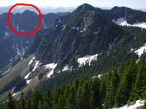
See attachment. As seen from the McClellan Butte trail. Mt Kent is in the middle. Anybody know what the name of the peak/ridge in the background is (just marked Point 4703 on the maps, even though that's not the highest point on the ridge), and whether anyone's climbed the obvious couloir on the NW (left in the picture)?
-
My guess is because it's softer than steel, so you might end up with stretched biners and bent crampon points...?
-
Any more beta? We're thinking about going up C-D this weekend. Was the road actually gated 1.5 miles from the TH, or just lots of snow?
-
That's part of the total energy input/output of an object, but when it comes to the extent to which wind affects refreezing of snow, I think evaporation is the primary factor (and probably a minor one compared to nighttime radiation, which is independent of wind).
-
Wind chill is due to two things that happen when wind blows across your skin: 1. it disturbs or destroys the thin insulating layer of air, warmed by your body, above your skin. 2. it accelerates the evaporation of moisture, which is an endothermic (cooling) process. These are basic physical phenomena and apply just as much to rock and ice as they do to people. But, the extent to which they affect different objects and surfaces does vary, and "wind chill" refers to the response of human skin specifically. So using a wind chill chart to predict snow conditions may not be very accurate. (Probably everyone has experienced the effect of #1 on sun-exposed rock on a cold day; it will be much warmer than the surrounding air if the winds are calm. #2 is one reason why thawed snow can crust up quickly on windy nights even when the temperature is above freezing - radiational loss of energy on clear nights is the other reason)
-
All I'm saying is that there are two facts about the accident: 1. the NWAC indicated on 12/28 that skier-triggered avalanches on steep lee slopes below high ridges were probable and that those slopes offered the greatest risk that day. 2. a person in a Mountaineers party died in a skier-triggered avalanche the next day on a steep lee slope below a high ridge. Thus the question I raised initially: why did a group organized by a highly safety-oriented organization end up on a slope that the NWAC claimed would have the highest probability of avalanching on a day when the baseline risk was "considerable"? If safety takes priority over fun - an ethic the Mountaineers are notorious for demonstrating - why didn't the group decide to head to an area that would offer a lower (if not zero) known risk of avalanche? I think these are legitimate questions to ask, at least for anyone considering signing up for a future Mountaineers ski outing. I haven't offered or encouraged any speculation on what happened once they left the parking lot - as you said, we don't even have a full first-person account yet, and we know nothing about the group dynamics, what stability tests they did, etc. Those facts will be instructive when they come to light and may help answer these questions.
-
No. The "a priori" knowledge this group did have (or should have had) was that the slope in question was basically a death trap, to the extent that no amount of local stability evaluation could have completely exonerated it. "Absence of evidence is not evidence of absence." I think the mistake this group made was to go to Cement Basin on that day in the first place, and to (perhaps) believe that their snow evaluation skills would allow them to find safe slopes in that area. All other decisions or actions leading up to the accident are probably irrelevant.
-
Of course snow science is inexact. But the risk that day, on that slope, was clearly high. The NWAC forecast on 12/28 (when this group would have had access to it) said in plain English: "the greatest danger is expected on mainly northeast through southeast facing slopes above about 5000 feet in the north and 5500 feet in the south where triggered slab releases are probable on steep slopes that have received wind deposited snow." What more would you need to convince you to stay out of Cement Basin that weekend?
-
It almost doesn't matter what local snowpack evaluation the group did or didn't perform. Either they failed to do any, or they did their tests but misinterpreted the results. If you're on a slope that your analysis at home told you is likely to be dangerous, and you dig a pit that tells you the snowpack is "all clear", how much do you trust that result? Personally, I'm conservative and relatively inexperienced. For me, a slope is good to go only if my research prior to the trip gives me confidence in its safety AND I don't find evidence to the contrary during the trip.
-
All of the current and last 10 days' worth of avalanche-related forecasts and data can be found here.
-
While it is true that you can find safe skiing at all levels of avalanche danger, it seems to me that this group chose basically the worst place to go that particular day. The snowpack in the Cascades had (and still has) textbook instability - rain crust (bed surface), followed by surface hoar from clear, cold weather just before Christmas (weak layer), followed by increasingly dense layers (slab). The most recent storm, on Friday, had deposited about a foot of snow during very strong westerly winds. Many natural avalanches released during that storm. Given these conditions, a prudent choice would have been lower-altitude, lower-angled terrain on windward or sheltered slopes (or to stay home). But instead they chose to ski on terrain that was very vulnerable - steep (35 degrees), lee (east aspect just below the crest), and high (6600') *. All of this information was readily available on 12/28 by reading the NWAC report, checking the Crystal Mt. sensor data for the past few days, and looking at a map. The fact that the slope in question had apparently been skied several times Saturday and Sunday without incident prior to the accident may have blinded the group to the fundamental terrain and snowpack dangers. This makes me wonder what sort of pressure the Mountaineers group leaders are under to stick to their outing plans - I assume that this was a previously scheduled trip to the Norse Peak/Crystal backcountry area. Cement Basin would have been the last place I'd have picked to go that day. * I'm going off of information posted on turns-all-year.com about the exact location of the accident, which is the most precise I've found - I have no idea how accurate it is (it gave a position of 46 56 37 N and 121 26 45 W, which is consistent with everything else I've heard). Reports about the aspect of the slope seem to vary between NNE to ESE. The location above is on an E aspect.
-
Some FRS radios now also have NOAA weather radio reception. We used one on Sahale a few weeks ago and it worked out reasonably well (reception is somewhat poor that far into the Cascades, but it was intelligible). Also, I find the NWS forecast discussion pretty useful. It's a fairly technical, qualitative analysis of the current weather picture. If you know a bit about meteorology, it gives you a much better idea what the forecast is based on, and how much confidence the staff meteorologists have in that forecast. That said, I still don't trust any forecast more than 12 hours out [ 07-31-2002, 03:38 PM: Message edited by: Peter Baer ]
-
The FS plan for the Middle Fork has two parts; a) allowing the upper road to revert to a trail (past Dingford creek permanently, past Taylor river seasonally), and b) developing the lower road (North Bend to Taylor river) as a "family-friendly weekend place," to use Fairweather's term. I.e. cleaning up the garbage dumps and putting in more campgrounds and trails. This is a good thing if it relieves crowding on the I-90 corridor trails and gets people to appreciate and preserve the MF valley. Seems like a fair solution. The upper MF road stabs deeply into the Alpine Lakes wilderness; the idea of the central Cascades becoming just a litte more wild and remote sounds pretty appealing to me.
-
I'd guess that the warm temps and 40+ MPH winds preceding the onset of snow would have taken care of any surface hoar that may have developed a few nights ago... Significant avy danger nonetheless due to the ice crust, though, no doubt.
-
I ordered some AT skis and bindings (Dynafit) from telemark-pyrenees.com, now the question is where to take them to get them properly mounted (in the Seattle area). Any suggestions?
-
I've got some miscellaneous nylon/perlon/spectra webbing and cord that's been sitting in the (dry & dark) closet for a couple of years. Some of it is dirty, some of it is still tied in knots. However, none of it has been exposed to significant wear & tear (abrasion, UV exposure, or excessive bending of the spectra cord). So the question is, how well does this stuff hold up when it's just sitting around at home like this? And on a related note, the rule of thumb seems to be that you retire all the gear involved in a big whipper: the rope, the harness, the pro that held the fall, etc. So what kind of fall qualifies for that? Does the pro have to be visibly deformed before it has to be replaced (I remember hearing that biners and other metal gear can suffer internally when dropped or otherwise stressed that weakens them without visible damage)? Do repeated smaller falls eventually add up to the equivalent of a big one? These may be silly questions about materials that have fantastic strength and are designed to take abuse... but I'm paranoid that a visual inspection of the stuff isn't enough to tell whether it really still is as strong as it was when it was new, and I can't afford to replace it whenever there's a doubt.
-
[ 01-07-2002: Message edited by: Peter Baer ]
-
quote: Originally posted by jeffers: Couple hints for torquing the odds your way if using GPS. When you plot your waypoints always include the elevations from the topo, and recalibrate the GPS elevation at each waypoint. At least at the bottom and the top anyway. GPS elevation can't be calibrated (without some external data to calibrate from, like a DGPS signal). You just need to make sure your map and your GPS are using the same datum. Under an unobstructed sky the GPS elevation will be accurate to within +/- 25 feet or so. If you let it sit still for a few minutes the accuracy will go down to less than 10 feet. Barometric altimeters, which some GPS units like the eTrex Summit have as a backup/alternative to the GPS elevation, do need to be calibrated - I suspect that's what you meant.
-
Gusts up to 126 MPH at Alpental last night according to the sensor there: http://www.seawfo.noaa.gov/products/OSOALP
-
Slightly off topic, but how do you pronounce "Entiat" anyway?
-
Yeah, I hope no one is camped high on the volcanoes tonight... hurricane force gusts predicted above 4000 feet. [This message has been edited by Peter Baer (edited 05-15-2001).]
-
P.S. even the plain eTrex interfaces with PC software like "Topo!" (though you need to buy the cable separately). So you can upload waypoints before leaving, trace your actual route on the topo after coming home, and so on. Very useful.
-
I've been very happy with the Garmin eTrex. Lightweight, compact, accurate and inexpensive ($120 at REI). They have a bunch of different eTrex "flavors" now, including one with a built-in compass, map, barometric altimeter, blah blah. But a) you should have a real compass as backup anyway, b) ditto for the map (and the electronic versions aren't yet detailed enough to be useful anyway), and c) I've found the GPS altitude to be about as accurate as an altimeter (high accuracy requires a reasonably clear view of the sky, moreso than for a horizontal fix, but you never have to calibrate it). Just go for the plain yellow one, you won't regret it.