-
Posts
3 -
Joined
-
Last visited
-
Days Won
2
tmbalboni's Achievements
")
Gumby (1/14)
3
Reputation
-
 tmbalboni changed their profile photo
 -
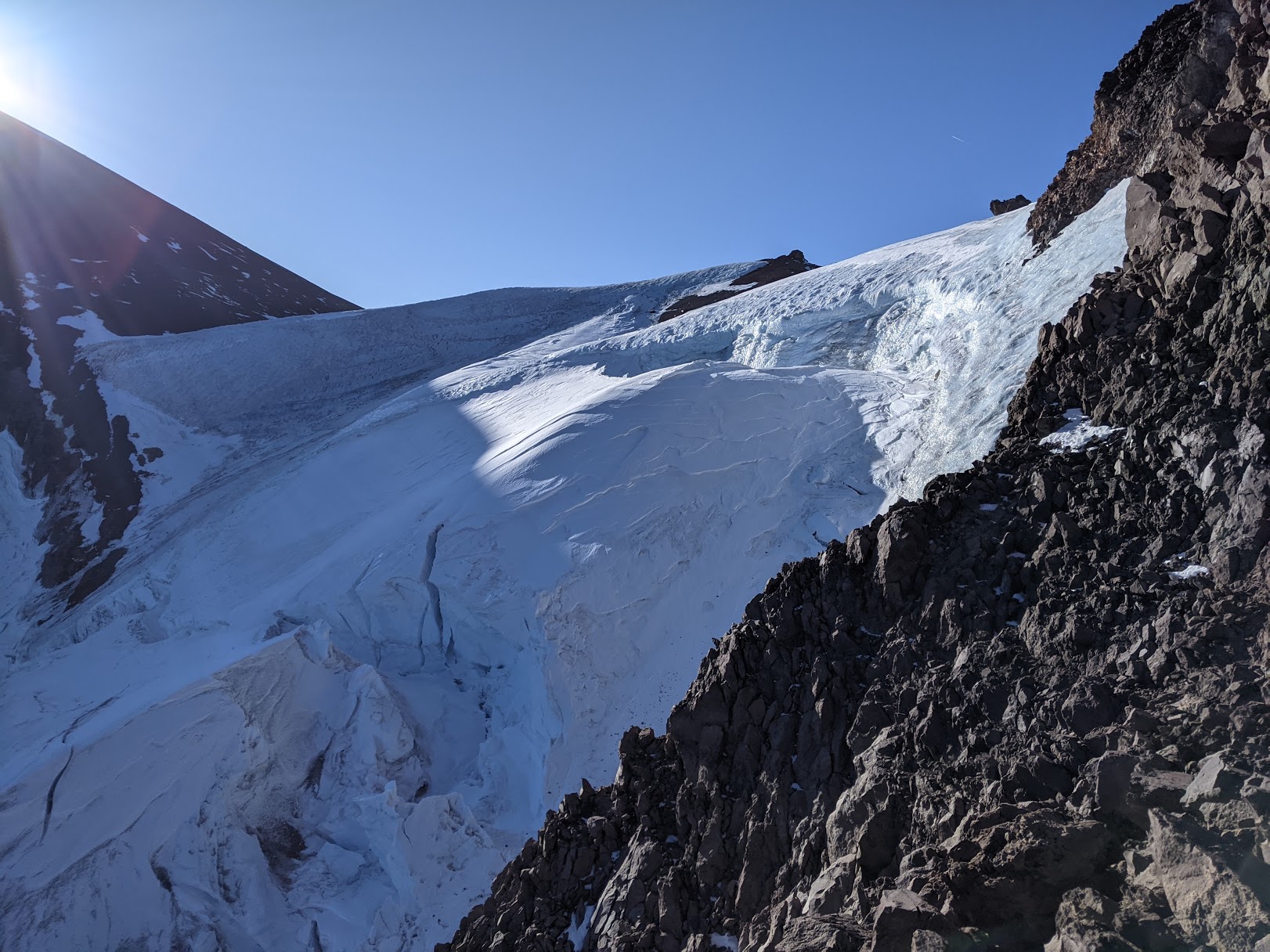
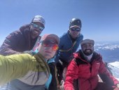
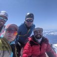
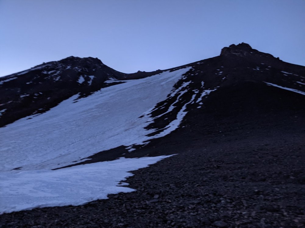
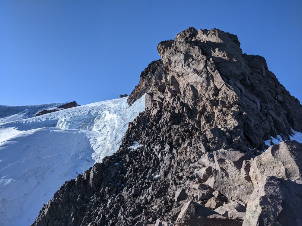
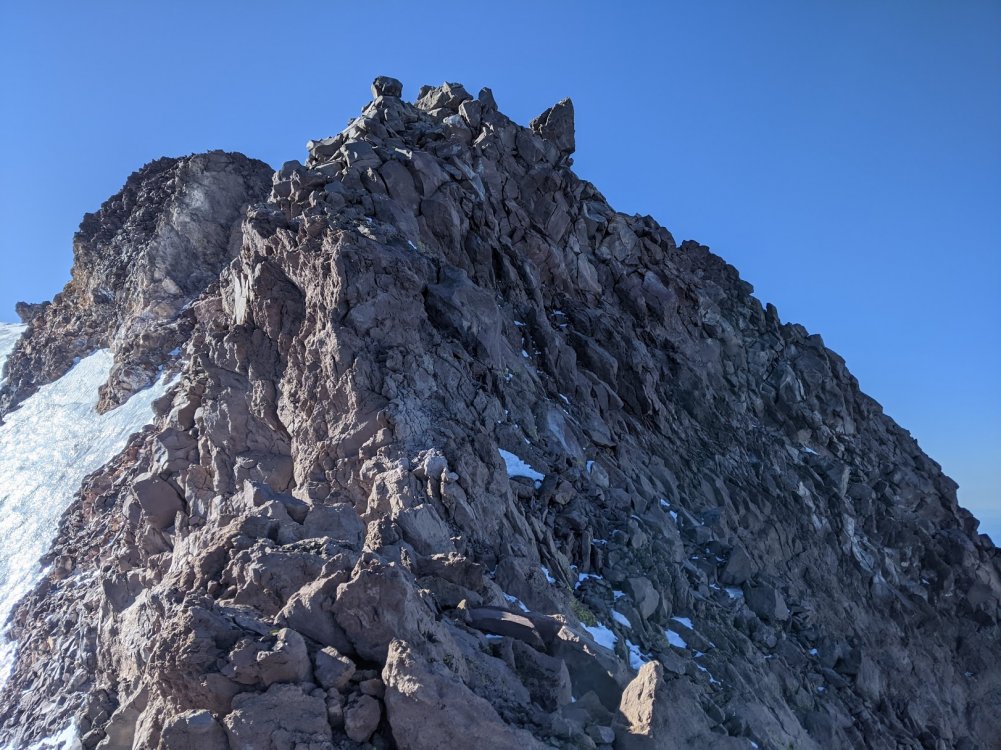
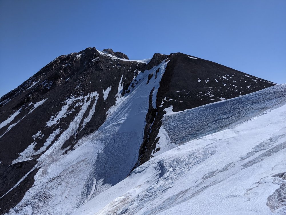
Trip: Mt. Shasta - Cascade Gulch Trip Date: 04/18/2021 Trip Report: Cascade Gulch April 17th - April 18th, 2021: Checking into the local forecast centers the night before this climb I read “If you plan to climb Mt. Shasta, now is the time”. Snowfall had been light and winds heavy throughout the Winter. The Mt. Shasta Avalanche Center noted that precipitation was 47% of normal. Our climbing window had a wind forecast of 10 MPH at the summit. Clear blue skies. Low of 17 degrees Fahrenheit on the summit. The Cascade Gulch summit bid began at 1000 in Bunny Flat. My three companions and I packed our gear, wrote our itinerary for the rangers, and headed to Horse Camp. The Cascade Gulch route had been described to us as having a crux at the point Whitney Glacier meets the ridge of the mountain. The options as we understood them for traversing the crux included: 1. Ice climbing slightly above the Whitney Glacier bergschrund 2. Traversing the ridge line itself 3. climbing down onto Whitney Glacier and crossing it. We had decided not to bring a rope or crevasse rescue gear. We brought our ice tools along and decided that we would either solo ice climb over the bergschrund or scamper over the ridge line. Within one hour we made it to Horse Camp. We continued clockwise around the mountain for another three hours and made it to Hidden Valley. The snow was fairly consolidated and we did not find it necessary to wear snow shoes. We set our base camp, looked around, and talked for a bit before turning in for our early morning summit bid. We awoke at 0200 and made it out of camp by 0315. No water was available at our Hidden Valley camp so we melted snow to replenish our water stores. We spent the next several hours heading up Cascade Gulch, staying climbers left to the bottom of the Gulch as we ascended. The Gulch was still covered and we walked on snow the whole way up. The saddle was obtained around 0530 with great views of Shastina. We turned away from Shastina when we hit the saddle gap and continued up a hill, maybe 800 feet, staying on the Eastside of the ridge. Snow was patchy as we climbed with lots of ice. After cresting this hill Whitney Glacier came into view. The ridge line provided a clear path and we stuck to the Eastside of it as we approached Whitney Glacier. Around 0700 we came to the base of a series of gendarmes. Below the gendarmes the route was completely covered in ice for several hundred yards with a 50 degree plus slope (guessing). The ice climbing would have required a several hundred yard traverse and maybe 200 vertical ft. gain. At the highest point in the bergschrund the traverse would put you just 10 feet above it, although that was not apparent to us until we could look back at the bergschrund after the crux was completed. This ice and snow route appeared suitable for ice screws and even snow pickets in some places. Unfortunately, we had decided not to bring any and the overall group confidence level for soloing the snow/ice traverse was low. We began exploring the rock towers and slowly making our way across them. Most of the rock was in good condition and we were usually able to find large pieces with good holds. Most of this traverse was Class III but entering Class IV terrain on several portions was unavoidable. At least three short sections involved exposed no consequence climbing. As we climbed we did loosen some rocks at times. Slow careful climbing and route selection was key on the rock towers. Approaching the last tower there was no way through it. The tower was a giant formation of choss. Climber's left was a steep ice drop off into the bergschrund, climber's right, towards the West Face, was a short but steep 45 ft snow chute down to the base of the last gendarme. We climbed down the snow chute and hugged the gendarme until we saw a small gap in the tower. We took this gap in and we briefly climbed on Class IV terrain until we poked to the top of the tower. From this point, we climbed back down onto the Eastside of the ridge and found ourselves on top of the ridge above Whitney Glacier. This section was relatively flat and we walked leisurely along until we hit Misery Hill. Misery Hill was almost completely barren. We powered up, encountered some more snow and ice once above, and navigated the short section to the summit. Coming down, nobody wanted to repeat our climb through the gendarmes. We exited down the Red Banks left of The Heart (climber's left), glissading where we could and making our way down to Helen Lake. Two of our party were sent to power through to Hidden Valley to pick up the gear. This group of two shot through the first window of Avi Gulch and did a traverse around 9,600 until Hidden Valley opened up. A rendezvous with the entire group took place at Horse Camp and we all walked out to Bunny Flat. Gear Notes: Standard mountaineering pack sans rack or rope. Technical tools included only crampons and ice tools. Approach Notes: See Trip Report

-
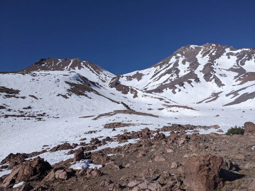
Trip: Mt. Shasta - Casaval Ridge Trip Date: 01/08/2021 Trip Report: Casaval Ridge January 8, 2021 - January 9, 2021: Headed out with my buddy Seth from Bunny Flat parking lot at 1:15pm on Friday. Mt. Shasta had received maybe a little over a foot of snow in the last week and it had snowed a little less than an inch Friday morning. Depth of snow at the Old Ski Bowl was reportedly 45.5 inches when we started. Moderate storms within the last (7) days caused some concerns. Recent snow fall in addition to high winds impressed into our minds that considerable avalanche danger above tree line was possible. We proceeded with vigilance and kept our ears open for shooting cracks and other disturbing sounds from the snow as we climbed. We also had concerns that due to the wind, Casaval Ridge on the North-West side of the ridge may not be sufficiently covered for a successful ascent. Travel with snow shoes, an avalanche beacon, probe, and shovel were a given. The Avalanche Center had identified North, East, and South side aspects of the mountain as potential moderate danger zones for wind slab. We felt that given the overall aspect of Casaval Ridge, we were in an okay position to suss out the terrain for a possible ascent. We had planned to sleep at the top of Giddy Giddy Gulch. Weather forecasts made us optimistic. Our No-Go was 30+ MPH winds or snow fall. At our campsite Friday night, winds were forecast for 30MPH, dropping down to 25MPH after midnight. We expected to start our ascent early Saturday morning from the bench in 30MPH winds, dropping to 20MPH as we climbed and staying at 20MPH until we returned to base camp. We arrived at upper Giddy Giddy Gulch at 4:15pm (9,800ft). We made camp just above the first window down into Avalanche Gulch. Wind speeds were high and gusts felt above 30 MPH. We spent 1.5 hours building a snow wall and setting camp. Camp was comfortable and warm in a four season tent. We woke up at 4:00am Saturday morning with the intention of starting our climbing at 4:45am. We began at 5:15am. We ascended the slope above Giddy Giddy Gulch and started the first 50 degree crux of Casaval Ridge around 6:00am. During this portion of the climb, we were between 10,300ft - 10,400ft. We traversed climbers left of the gendarmes maybe a hundred meters uphill. There was little snow. Many rocks were exposed below the gendarmes. The snow was solid for maybe two inches but the rest of the ice axe shaft would fall into powder. Snow conditions were not sufficient to make this climb safely. We aborted the attempt and observed lenticular cloud cover moving over the summit shortly after sunrise. Gear Notes: The four season tent ended up being essential given the exposure along the ridge and the high winds we encountered. Approach Notes: After feeling high winds at one of the 50 degree slopes I believe that this route is best completed with wind speeds under 20 MPH. For the next attempt my personal no-go criteria will be changed from 30MPH+ winds to 20MPH+ winds.
-
Hey there! I'm a 31 YO male living in the town of Mt. Shasta. Looking for a mountaineering partner to explore more of Mt. Shasta's glacial and alpine offerings. My goal is to climb all 14 routes (already have 2 down). I already have another climber (another Mt. Shasta local, 32 YO male) competent in glacier travel/alpine climbing. Looking to create at least a team of 3 for safety reasons. Former Marine, experienced thru-hiker, high level of experience in map and compass navigation, skier, and beginner glacier travel/alpine mountaineer. Safety is paramount. Proper trip planning is essential. I have a 9mm 40m single dry rope, snow protection, slings/cordette, and use the partner pulley/tibloc/micro traxion Petzl system for crevasse ascent and setting up hauling. Competent with munter-mule/prussiks/ and other essential mountaineering knots. I of course have all non-technical gear as well including a 3-person four season tent. For orienteering I use a map of Mt. Shasta, a high quality compass, and a Garmin GPS. My technical skills include: 1. Self-Ascent out of a Crevasse 2. Setting Protection 3. Prepping the lip 4. Setting up a hauling system 5. Belaying a climber 6. Moving on the rope with a running belay If you have any interest in teaming up please send a text to: (831) 345-9638. My first name is Theo.