


Todd Anderson
-
Posts
60 -
Joined
-
Last visited
Content Type
Profiles
Forums
Events
Posts posted by Todd Anderson
-
-
Thanks for the tip Norman, ended up with a RX100 Mk1 for significantly less.
-
--EDIT: got one, thanks!--
I want a camera that's small enough to clip on a harness or outside of a pack all the time. My friend has a first-generation RX100 that seems pretty ideal, but I'd also be interested in a Canon G-series, Lumix LX100, and other cameras in that category.
Anyone looking to get rid of such a camera? Would much rather buy here than eBay. Located in Seattle.
-
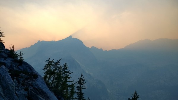
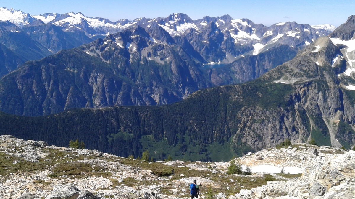
The smoke did not take long to move back into the Enchantments after the rain cleared it out on Saturday
-
Gear notes: helmets, riot shields,
Glad you guys are okay!
-
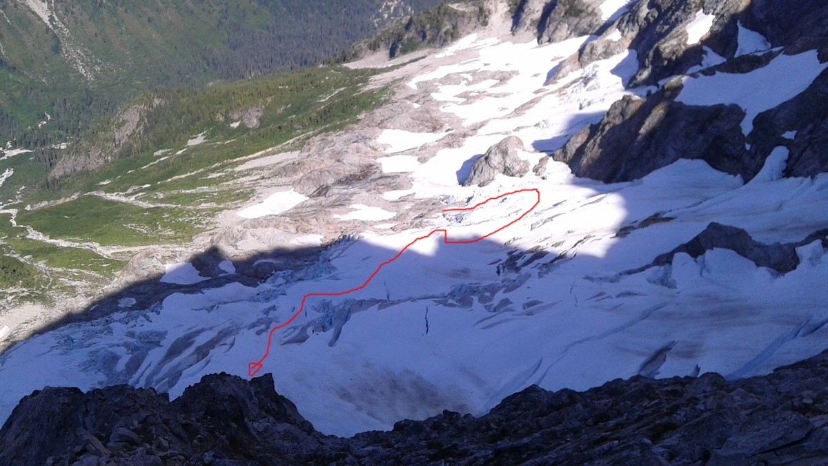
Definitely leave the skis at home. When we did it S-N we skied:
1. Spire Point to just below White Rock Lakes (aka the Dana Glacier),
2. a quick traverse of the South Cascade Glacier,
3. the Le Conte Glacier,
4. Le Conte ridge down to Yang Yang Lakes,
5. the Middle Cascade Glacier, and
6. Cache Col to Cascade Pass (almost)
If we were going N-S, we could have skied:
1. Spider-Formidable Col to Yang Yang Lakes,
2. Le Conte ridge to bottom of Le Conte glacier,
3. Le Conte-Sentinel Col to South Cascade glacier,
4. South Cascade Glacier to White Rock Lakes,
5. Spire Point to Cub Lake
I suspect all these runs will involve at least one carry now.
The problem with the N-S runs is that most of them are not fall-line; you're just trying to maintain elevation as long as possible. This will be much more difficult as the snow starts to melt out, mostly because moats you have to traverse under will be bigger and further downhill. What would have been the best N-S run, Spire Point to Cub Lake, is south-facing and could be melted out by now.
We skinned from Cub Lake to Spire Point, but otherwise either booted or skied the rest. The frequent transitions and steep traversing made booting faster.
-
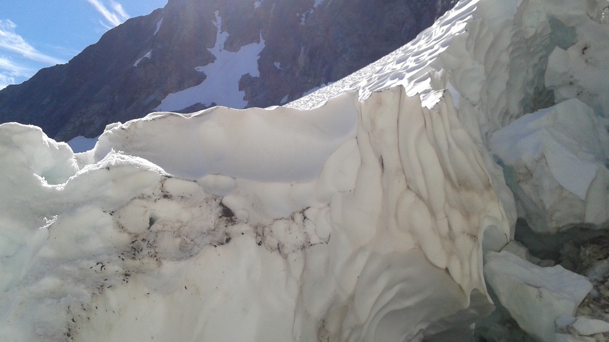
I went S-N on July 1-2, taking the Downey Creek trail to Bachelor Creek, to Cub Lake, to the Spire Point col. There has been some work done on the upper Bachelor Creek "trail", as evidenced by orange flagging, and generally speaking the trail is pretty well beaten-in. If you miss the flagging, the easiest way down would be through the pine forest on the descender's right side of the valley.
Unless you have skis, you shouldn't have much trouble even if you end up tunneling through alder for a bit. Going uphill through alder with skis was fun.
-
Anyone been on this route recently?
-
-
Bought this approach setup this fall for a trip that never happened. Should have posted before AK season, I guess. Anyway:
Photos here: https://goo.gl/photos/GGPuqojtfijerQbC6
Hagan Tour Carbon, 167cm (straight pull), I believe a ~70mm waist. Edges, bases, topsheets are fine. It's not a new ski. Topsheet and base graphics depict strong shirtless men flexing, which improves your chances of a successful alpine-style ascent. Super neat-o Neptune Mountaineering decals and a piece of tape that says "Colin" included for free.
Silvretta 404, I believe the medium/normal size ("N"?). Of course I forgot to check this morning. Fits size 42.5 La Sportiva Nepal Evos, which I think are around 300mm BSL, near the middle of the adjustment range.
Advanced Base Camp straight mohair skins. These have a small metal hook that fits in a groove in the tail, and a stretchy rubber tab for the toe similar to BCA skins. Glue isn't great, but I didn't have any problems with the skins coming off or getting snow under them during the one time I used these.
I paid $170, and would like to get that back. I have seen Silvretta setups sell for over $300 recently. Would really prefer not to ship. Located in North Seattle; can meet somewhere between Greenlake, UW campus and SBP. Would consider selling just the bindings if you really really don't want the skis, but don't expect the price to drop very much.
-
Email sent; small dark blue BD Dawn Patrol LT softshell in good shape.
-
I've got a pair of old Sportivas around that size that have been converted to fruit boots if that's what you are going for. Come with Grivel Racing Crampons bolted on so not quite just beer but I'd pass em on for $75 since I never use em.
That's a damn good price for fruit boots, but this will be an altogether sillier project than that. In any case I will be picking up some old Asolos tonight.
-
Edit: probably have some, pending pick-up
Anyone in Seattle have a pair of step-in crampon-compatible boots lying around they're trying to get rid of? Leather slightly preferred over plastic; something like La Sportiva Nepals would be perfect. Preferably around size 42, but this isn't too important either. Don't care about the condition of the uppers as long as the sole will still hold a crampon. Will be used for a silly project, so I can't justify spending more than the cost of a fancy 6-pack of your choice.
Thanks!
-
Turns out I have more time off than anticipated and flights are cheap Thanksgiving day, so I'm headed to the desert to climb splitters with everyone from CO. There may be a Seattle-area group headed to Hyalite, though; I will certainly be there for the ice fest.
I am assuming that if ice starts coming in in the Lillooet area we'd hear about it on the West Coast Ice facebook page, but maybe not. In any case, it looks like highs in the 40s for the forseeable future up there.
-
The late great Andreas Fransson skiing the Col de L'Aiguille Verte (line #1 on the topo):
Route detail on the Couloir Couturier (line #4) including some ski beta and history: http://www.camptocamp.org/routes/54983/fr/aiguille-verte-couloir-couturier
-
DPS and Dre, emailed you guys.
Anyone else: andersontodds at gmail
-
Yeah drying gear sounds like an issue. Unfortunately my ice partner list is not deep; one of the attractions of Lillooet is the density of TR-solo-able ice. If I can round up three more I guess a motel room would be affordable.
-
I have a few 4-day weekends coming up in the later part of this year, and if Lillooet ice is in good shape I think I'll head up (from Seattle). Can anyone recommend somewhere to camp for cheap up there? My station wagon is set up to sleep in, so really all I need is a parking space where I won't be harassed. Would also consider hostels, but Google isn't turning up anything cheaper than $50/night. I'm not very familiar with western BC north of Whistler, so any help would be appreciated.
-
Sportivas sold!
-
Nick, sent you a PM
-
I have two pairs of running shoes, a pair of mid-height approach shoes/hiking boots, an old pair of ski boots, a 24 liter Black Diamond climbing pack and some Petzl crampons. Prefer to meet in Seattle area, or we could work out shipping.
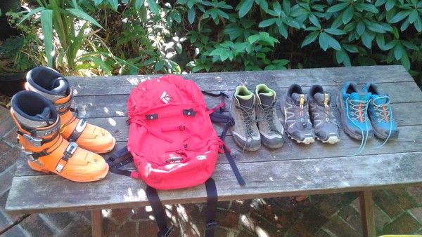
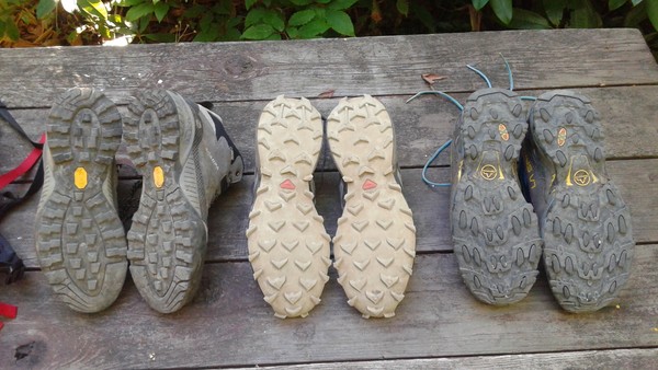
SOLD La Sportiva Ultra Raptor GTX, size 42.5/USM 9.5. Bought in like new condition, worn once to hike up to the snow on Adams. Too wide for my feet, and I'm not really sold on the Gore-Tex trail runner concept.
$40
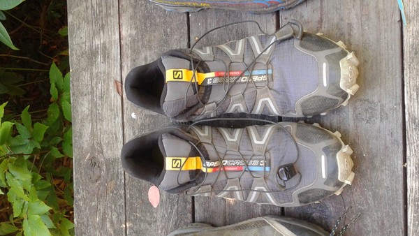
Salomon Speedcross 3, size "43 1/3"/USM 9.5. Bought new a while ago, forgot I wore a 9 in Salomon. Probably around 20-30 miles on these shoes.
$60
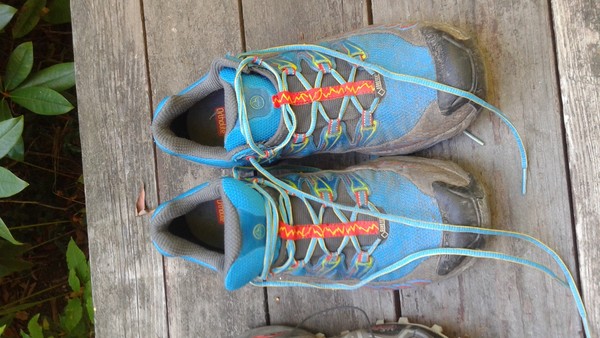
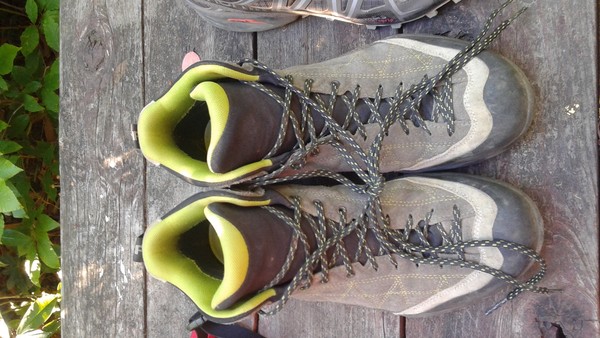
Scarpa Zen Pro Mid GTX, size 41/USM 8. Bought used in good condition after I murdered my feet in full-shank boots on a Pickets hike. Used on one scramble up North Twin Sister, during which I found out the heels were too large. Couldn't return them to Second Ascent because it had been just over a week.
$60
and here are the shoe soles; L to R: Scarpa, Salomon, Sportiva
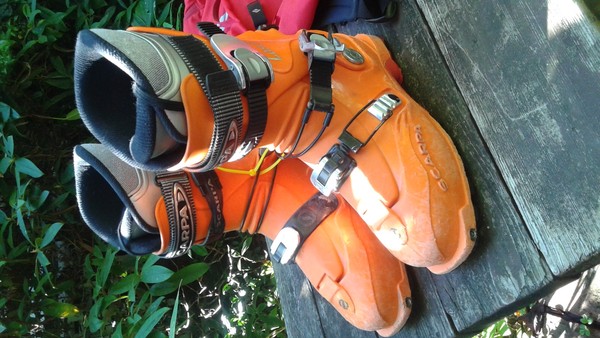
Scarpa Laser ski boots, circa 2005 or so, shell size 26/26.5. Bought (from a CC member) in fall 2015 to get into touring out here, didn't quite fit my low-volume feet right. Decent boots if you're looking for a cheap first pair, or if you want to try this badass Frankenboot mod.
$30
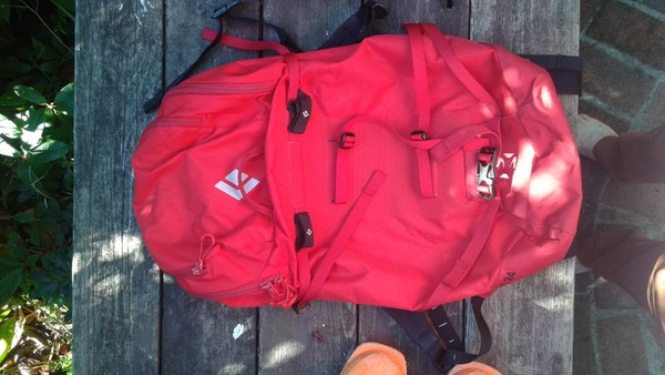
Black Diamond Axis 24 pack, size M. Bought new in 2014, I think; used on a few alpine rock climbs and hikes. Don't really use it anymore since I got some other packs.
$50
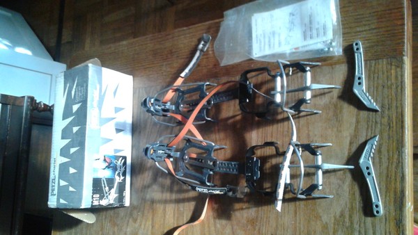
SOLD Petzl M10 crampons. Set up as monopoint, but come with 2 extra unused frontpoints in case you break one or want to set them up as dual frontpoint. Bought used from Second Ascent, then ended up with a pair of horizontal frontpoint crampons which I use for everything now.
$60
Feel free to make offers, and let me know if you want more photos of something. Thanks for looking.
-
Hey Davey, hope you guys had a good trip! Also thanks (to one of your group, anyway) for the rappel beta; we probably would have figured it out, but I think you saved us a lot of time Sunday morning.
-
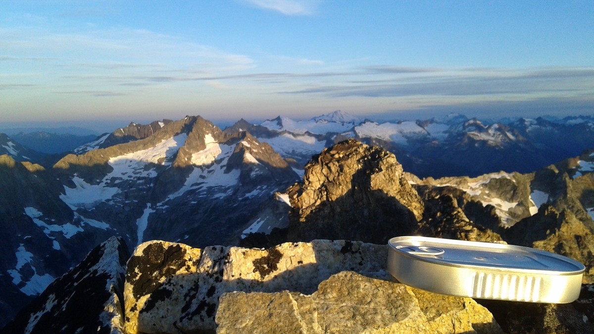
Trip: Goode Mountain - NE Buttress
Date: 8/12/2016
Trip Report:
David officially became a PhD candidate on Thursday, so we went out to the Knarr Bar to get smashed and play shuffleboard. Then on Friday morning we left to go climb Goode Mountain.
We had both read a lot of TRs of Goode over the last month or so, but we forgot to print anything out and didn't bring a map, so navigation was based on foggy hangover memory. Somehow we totally nailed the approach to bivy at 5400'-ish; we definitely found the "magical alder tunnels" that Ilia S. refers to in his TR. It was sunset when we found a good bivy site, which was not large enough for the Firstlight. The Firstlight did make a good pillow, though.
We slept in on Day 2 and awakened when a party of 4 tromped past us on their way up. Shit, they're going to take the summit bivy! They got a solid hour head start on us, but we eventually made it up the rest of the slabs and onto the glacier. The cracks are pretty big, but we found a way that started a ways east on the glacier that didn't involve any ice climbing or crack-jumping.
The moat was deep near the toe of the buttress, but maybe only 5 feet deep and easy to downclimb where we got on rock, i.e. slightly uphill and east (climber's left) of the buttress toe.
The glacier was definitely making worrying noises, and the north face was dropping bombs pretty frequently later in the day, so an earlier start probably would have been a good idea. I don't think we made it onto the rock until almost 10 AM because of our late start.
Getting onto the ridge crest was kind of dicey, since the rock was extremely loose. We belayed two short pitches until we gained the crest, then simuled probably 500m in roughly 100m pitches. We pitched out the harder section about 3/4s of the way up, and since we were using a doubled twin we could only do 30-35m pitches. This was quite slow; we had been steadily gaining on the party of four ahead of us until we started pitching things out.
At some point things got easier, and we did two more long-ish simul pitches to a ledge just below a bivy ledge near the summit. I saw two of the party of four on that ledge, so I was worried that the other two may have continued to the summit and we would have to share the bivy with them. Fortunately the entire party of four turned out to be on this lower ledge, so we did one simul pitch to just below the summit, and one 15-meter pitch to the summit. We didn't pitch the Firstlight because the weather and position were so awesome, so I ended up carrying a 3-pound pillow. I also carried summit kippers, but didn't have the appetite to eat them in the morning.
On Sunday morning we discovered that Rudy the Rat had nibbled on my partner's climbing shoes, and also taken my socks. I was trying to figure out if I had enough moleskin to construct something to hike out with when my partner produced a spare pair of socks. Awesome.
We rapped past/through the party of four, who were just starting their summit bid, and made it to the SW couloir and down those rappels pretty easily. We weren't really sure how to get down to the Park Creek trail, though, so we ended up going skier's left into a large open bowl that turned into a steep-sided canyon/drainage, and following the skier's right side of the drainage to the flood washout/burned forest.
I thought I remembered a photo of people descending the left side of the washout (i.e. not actually in the washout), but David was leading the way here and he said a line straight down the middle of the flood washout would go.
It was burnt alder hell at the bottom and we each took a few big scree falls, but we eventually made it to the Park Creek trail at 1:30 pm. We thought it would be 19 miles out from there, but a sign when we rejoined the PCT suggested it would actually be 21. In any case, we did it in 7 hours, and got to the car at sunset. Fortunately we made it to the nearest open gas station in Marblemount for sugar/salt/caffeine.
Gear Notes:
1x nuts, 1x cams .3-2, a bunch of slings
65-70m twin rope, i.e. only one (a longer lead rope would have been very useful for bigger pitches but the light weight of the twin rope was nice)
Climbing shoes, tent unused/unnecessary; kippers unused but necessary
Put your socks in the steel mesh bag with your food
Approach Notes:
Long walk on the PCT, leave North Fork trail and cross North Fork at cairns, then choose your own adventure
-
When you use the MSR Cam Rings, do you have a single cord strand fixed to the tent tie-out, then the adjustable loop at the stake end? Or a fixed stake loop and the adjustable loop at the tent end? I have Cam Rings on my flat tarp (in the former configuration), and I find the tension extremely difficult to adjust, since there is so much friction between the adjustable loop and the stake.
-
Looking for a 2-burner propane camp stove, e.g. Coleman Triton or similar. Would prefer to meet in the Seattle area, so I can make sure it works. I'll bring propane!
(got): Sony RX100 or similar point-and-shoot
in The Yard Sale
Posted · Edited by Todd Anderson
I paid $205, and spent another $50ish on cases, batteries, etc. Got lucky and found an ebay auction that only had one other person looking at it. Got it in the mail yesterday and am very pleased with it so far. Excited to be able to take photos one-handed, on-route; something that's pretty hard to do with a phone.
Comparison between my Motorola Moto G4 (phone) and Steph Abegg's RX100:
Moto G4:
https://farm5.staticflickr.com/4332/37030874371_98afeacef1_o.jpg
RX100:
https://farm5.staticflickr.com/4380/36983321046_b4ba90c233_o.jpg