jlawrence10
-
Posts
55 -
Joined
-
Last visited
-
Days Won
1
jlawrence10's Achievements
")


-
Done all of the above. Thanks!
-
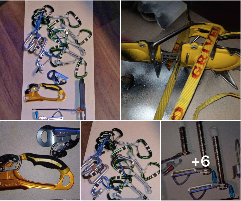
Hello all, Recently a bunch of nice gear popped up for sale on Facebook with a suspiciously low price, and an even more suspicious description (including references to "cleats" and "hooks"). Long story short, I bought it, in hopes of reuniting it with its original owner. There are some distinguishing things not pictured here, so describe those and it's yours. Hoping to recoup my $80 outlay. Best to email me: jlawrence10 (a t) mac (d o t) com. Portland, OR. Josh

-
Mt. Stuart climbs FROM Core Zone? (Edit: Or Colchuck!)
jlawrence10 replied to jlawrence10's topic in Alpine Lakes
Oh that’s right! I forgot that the Core permit lets you camp in any zone! That’s perfect - thanks so much for the reminder. -
Edit: Did a little more research, and while it's AWESOME that I get to stay in any of the zones, I'm thinking that Core Zone and Stuart climb in this one trip might be a bit ambitious. I'll schedule a Stuart climb, likely from the south, at another time... So, advice on getting to Colchuck Peak from the Core Zone? Is up and over Dragontail realistic, as it appears from a quick glance at the terrain? Thanks in advance, really appreciate the advice so far! --------------- Original post below: --------------- Yes, I searched the forums, and yes I googled it, but thought I'd ask here as well... Does anyone know if there is a route from the Core Zone of the Enchantments to get onto one of the easy routes on Stuart? I think I was looking at coming in from Colchuck Lake and up the Colchuck Glacier area, but I scored Core Zone permits, and would love to not go up and down Asgard to get there. This is for September, so not too much snow, but possible glacier considerations? I am not looking for hard climbing, I'm looking to get to the top. 'Cause, yea... Thanks in advance!
-
Apologies if this is not the correct forum for asking, but I'm looking to rent or borrow a satellite communication device next week, from 9/5-9/11. Most importantly it would need to reliably RECEIVE texts/calls. If you care, this is for a friend whose wife is 8 months pregnant who really wants to come on a trip with us. I don't know what a reasonable rate would be, but I can promise you it would be taken great care of - we are both very considerate and responsible, even more so with other peoples' gear. We'd also obviously agree to pay for replacement in the event of loss/damage. Thanks, let me know! Best way to reach me is email - jlawrence10 (at) mac.com but I'll try to keep an eye on the forums and my mesages.
-
Trip: North Sister, Oregon - Southeast Ridge to standard west side ascent Date: 7/31/2017 Trip Report: TLDR: Don't climb this mountain in the summer! So North Sister has been on the list for a while, if only to fill out the "Highest Oregon Cascades" checklist. Good reason, right? Anyway, this climb at this time of season was described to me by people who know as "inelegant" and "not aesthetic." To say the least! 85% of this climb was horrible. And yet, as always, it was totally worth it! We approached from Pole Creek, and camped at tree line (around 6800 feet) down below the Hayden Glacier, maybe a half mile south of the southeast ridge. Delightful camping there. Lots of water, beautiful spot. We left camp around 2:00 AM and headed north to gain the southeast ridge. Nothing fancy, just went north until we hit a flat spot, and then turned left up the ridge toward the mountain. The footing seemed loose getting up there, but we would look back on this footing with very fond memories in the long run. Headed up the southeast ridge. We had read to pass most features on the left (south) and when we did, things were pretty fine. We passed a couple on the right, and things were... not as fine. Scary at times; just loose and exposed, but manageable. It's just SO MUCH LOOSE ROCK AND SAND. Sunrise: View of the east face from the southeast ridge: Eventually the southeast ridge hit the south ridge (hard to say exactly where - it's all a jumble up there) and we headed up the south ridge and made our way to the terrible traverse. Maybe I'm harping on this, but it was SO MUCH LOOSE ROCK. I don't know the technical definition of "scree" or "choss" or any of those, but I'd guess we hit them all. At one moment, this summed up my feelings about the whole endeavor: Got to the traverse, and it looked only semi-terrible. I'd say about 60 yards across, but very steep, very firm, very exposed. Looking north toward the bowling alley, hard to see it all in this pic, as it kind of bends around and away: Rather than opt for the more elegant, traditional run out traverse with our pickets, we headed up the snow to the wall, and went for a less elegant but seemingly safer "moat technique." The moat was big and stable, and we felt good all the way around. Here I'm facing back to the south at my partner: The climb down out of the moat was maybe the sketchiest part of the climb - basically straight down, one foot in the snow and one foot on the rock/gravel/ice/wall, but only about 15 feet until we hit the relatively stable crap right at the bottom entry to the bowling alley. Exiting the moat: The bowling alley was totally dry, and a relative dream to climb at this point. Stable rock, no ice or snow anywhere around or above us, and nothing falling: Solo scrambled up the bowling alley to the plentiful rap slings, then up to the summit ridge, and then to the top! Had the mountain to ourselves all day. (Passed one team around 8500 feet on the southeast ridge in the distant dark, but never saw them again - although where the hell else could they have been going?!) The summit was sunny and literally like 70 degrees, which can be concerning, but given that the only snow and ice on the whole route was the bit on that north facing traverse, we felt ok about it. Rapped down the bowling alley - two fun pitches with good pre-existing webbing/cord in place got us back to the bowling alley exit. Here's the traverse looking south: Opted for the moat exit on the way out as well, and it went fine. Here I am climbing back up into the moat: Then down the (horrible, crappy) south ridge, off the west side this time to the BLESSED snowfields, and then a nice long hike on delightful snow all the way back to camp. I LOVE CAMP. -------- Here's a pretty fun video of the descent from the summit to summit ridge. Looks WAY sketchier due to the angle and GoPro "fisheye effect." This was probably the safest and most secure we felt all day. Gear Notes: Didn't use pickets or ice screw, just used our gear for rappelling the bowling alley, and I think it was well worth it just for that. (If only to bump the "fun factor" from 10% to 15%.) Approach Notes: Southeast ridge may well have been the best way, but when I was actually ON the southeast ridge, I was looking longingly at the snowfield approach to the south ridge, which may have been better. Probably would have been, from our camp. From Pole Creek? Your call. I would just pick a different mountain.
-
Recommendations for beginner trad routes at Smith?
jlawrence10 replied to TwoFortyJeff's topic in Rock Climbing Forum
Round River on Koala Rock is fun and so easy that even I could lead it. It has some bolts, but 'requires' a couple gear placements. It's 4 or 5 pitches, so definitely fun for practice, plus you get to the top of a really big rock. Long hike over there, though. I think it might be 5.6 but could be as low as 5.4? That seems pretty damn low though... It does have a bolted option for the last pitch that is 5.8 and pretty fun. -
This is an oldie but a goodie: http://www.outdooroddities.com/wp-content/uploads/2008/07/grizzly_bear_warning_sign.jpg
-
North sister conditions/trailhead access
jlawrence10 replied to DrCaterpillar's topic in Oregon Cascades
Great stuff, little bit fisheye but good pics. Thanks! -
North sister conditions/trailhead access
jlawrence10 replied to DrCaterpillar's topic in Oregon Cascades
Any recent reports on North? We're looking at the weekend of July 24th, but I haven't seen anything recent... mtnhippy, did you go up over the 4th? -
Alpine or Ice: Viviane stemming the crux on Devil's Kitchen Headwall, Mt. Hood, Oregon.
-
We did that route last year in July, and really saw no reason to rope up whatsoever. Once you get out above treeline, from what I recall, you ascend through some bowls straight up toward the mountain, then bear right (north) a little to gain the ridge that heads directly up to the saddle between middle and north. At that point you leave any crevasses down to your left on the Hayden itself. We roped up on the way down, mostly for practice, and pitched out the slightly steeper, firmer part on the way up for practice and comfort. You can check out pics here... http://gallery.me.com/jlawrence10#gallery ...if you want. There is a perfect camp site right around 8500 (if I recall correctly, and I might not) as the trees start to thin out. If I can find coordinates I'll send them your way. If you have specific questions, shoot me a PM. Have fun!
-
[TR] Mt. Hood - Devil's Kitchen Headwall 5/21/2011
jlawrence10 replied to rocky_joe's topic in Oregon Cascades
Thanks for the report. Saw your lights near the bottom of the chute as I approached Hogsback right around 3:00 or 3:15. Shoulda taken a picture for you. As for the helmet, I wouldn't care and would let someone choose, but if you're climbing on a long rope without any pro it is irresponsible to lead a team without a helmet. One piece of ice knocks you out, you fall past your team and keep going, and take out others below you, next thing you know a Blackhawk is crashing on Hogsback. In other news, did any of the 75 people I passed on the way down Friday morning find a Black Diamond headlamp? It's mine... Thanks! -
The advice on gear here is sound. Mostly scrambling with just a few belays. The best tip is to save weight and carry just one 60 meter rope. The rappel method outlined here: http://www.summitpost.org/owen-spalding-var-owen-chimney/160588 ...works great, and isn't as 'tricky' as it sounds. Just go to the far rap station, and keep right (rappeler's or climber's right) as you go down, and there's plenty of rope to get down, untie, and then scramble down.
-
My team of 5 wanted to go up Rainier via the Emmons two seasons ago, and we were trying to decide guide or no guide. We decided to spring for crevasse rescue courses with Timberline Mountain Guides, do a bunch of practice on the mountain and in the garage, and manage our own prep and gear. Best decision we could have made. We made the summit, and I had to climb out of a crevasse at 12,000 feet after a snowbridge fell out from under me. The team arrested the fall, anchored my climb out, and we set up a belay to get everyone around the now-trickier crossing. The sense of accomplishment was enormous, having done it on our own, and we came away with a ton of knowledge and experience that we wouldn't otherwise have had. Good luck, whatever you decide to do. PS - I know Timberline Mountain Guides out of Bend has been permitted to go up Emmons on Rainier before. They're awesome and would be worth at least a call.