


Steph_Abegg
-
Posts
269 -
Joined
-
Last visited
Content Type
Profiles
Forums
Events
Posts posted by Steph_Abegg
-
-
I am unhappy to note, however, that one of the photos seems to show you camping on vegetated ground, which in a busy place like The Enchantment Basin seems to me a very unfortunate practice.
Unfortunately, melting hoarfrost during the sunny day turned the usually great camping at the head of Gnome Tarn (which you can see in the first photo above) into a sodden mush...hence, the poor backcountry edicate....sorry....
-
Trip: Prusik Peak - West Ridge
Date: October 18-19, 2008
Trip Report:
My sister, Booth, and I spent the weekend enjoying the beautiful brilliant larch trees in the Enchantments. With the sunny skies, we were inspired to head up the always-classic West Ridge (5.7) of Prusik Peak. We simulclimbed the route in a couple of quick pitches, and had a great day!
I've posted lots of photos (including some night photography as usual) from our weekend in the Enchantments.
http://sabegg.googlepages.com/prusik2
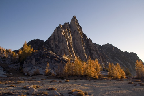
Prusik Peak in fall colors:
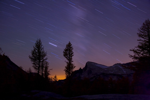
Star trails over the Upper Enchantments:
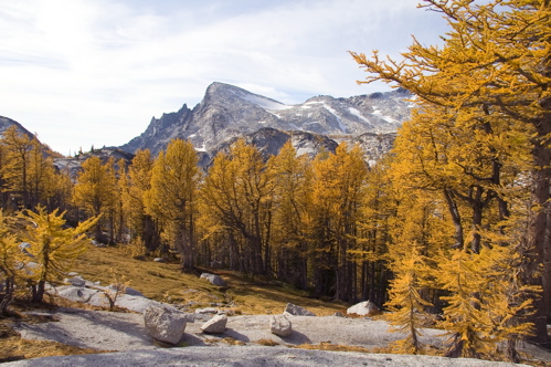
Larch trees in the Enchantments:
-
Trip: Three Fingers - Night Photography at the Lookout on the Summit
Date: 9/10-11/2008
Trip Report:
It took awhile, but summer seems to have arrived in the North Cascades. My friend Douglas and I took advantage of the September sun and hiked up to the old Fire Lookout on the summit of Three Fingers. We stayed overnight on the summit, as for me one of the main draws of the lookout was to take some night photography up there. It was a beautiful night with the moon, stars, city lights below, and candlelit lookout.
I've posted a trip report and photos on my webpage:
http://sabegg.googlepages.com/threefingers

-
Looks like lots of glacier recession in the Canadian Rockies too. Better enjoy those glaciers while we can!
-
have any Ptarmigan Traverse pics?
posted some now!
Little bit of glacier recession on Formidable in the following photos, although with the cool and wet summer this year, perhaps our glaciers will start to grow back...

My parents and uncle and aunt at camp on the first night of a week-long adventure on the then mostly trail-less Ptarmigan Traverse, July 25-31, 1979

On an overnight day-hike with my mom to climb Mt. Formidable, Aug 14, 2007
-
I've put together a page on my website showing comparisons of photos I've taken vs photos my parents took while mountaineering in the same areas in the 1970s and 1980s. It's very interesting to see how the North Cascades have changed (or not changed) over a generation.
Check out the comparisons on my webpage at:
http://sabegg.googlepages.com/comparisons

-
How much weight for floorless vs. floored tent? How did the pack weight feel when doing the North Buttress of Fury? Did you have sleeping pads (since you mentioned sleeping grooves)?
The MegaLight weighs 1 lb 14.5 oz (without the pole, which weighs an extra 7 oz, but you can use trekking poles as we did). THere is a floor insert you can buy that weighs almost as much as the tent (1 lb 12 oz). Extra weight, not necessary until you get stuck on a 3-night snow bivy....
The pack felt a bit hefty on Fury, since we still had 3 more planned nights (ended up spending 4 more nights out). But not too bad, overall. With my camera gear, I might have been around 40lbs, but most of Fury is 4th to low 5th, so it was more an athletic challenge, with the pack only being a real hindrance on a few moves.
We had sleeping pads, and fortified this with various things (packs, pack inserts, tortillas) to keep as far off the snow as possible. But the cold seeped through and after 3 nights butt groves were prominent. A floored tent would have contained more warmth, but would have added to the pack weight too. Overall, the Mega Light was a good tent for the trip, and held up quite well in the high winds on Fury. Should have just built an igloo up there, if we'd known we would be stuck up there so long!
-
I have to agree with Reid, your night photography page is stunning. Especially that Milky Way shot!! Atsa keeper! Reminds me of John Dittli's photography.
Thanks. It's not always easy to leave the warm sleeping bag or carry the extra 7lbs of camera gear, but it's always worth it in the end. In case others are wondering "what night photography are these guys talking about?" here's the direct link to this page of my site:
http://sabegg.googlepages.com/nightphotography
This photo was taken from Frenzel Camp on our last night of the traverse. It is a 20 minute exposure of star streaks and lights of civilization over Baker and Shuksan.
-
Trip: Pickets Traverse - Up the Little Beaver trail, over Whatcom, across Challenger, up the NB of Fury, over Outrigger Peak, through Ottohorn-Himmelhorn Col, out Goodell Creek Trailhead
Date: 8/5/2008 - 8/12/2008
Who: Steph Abegg, Donn Venema, Jason Schilling
Trip Report:
Day 1: Up Little Beaver Trail
Day 2: Over Whatcom Peak to Perfect Pass
Day 3: Across and up Challenger and down into Luna Cirque
Day 4: North Buttress of Fury and camp on summit
Day 5: Stuck in a snow storm on the summit of Fury
Day 6: Still stuck in a snow storm on the summit of Fury
Day 7: Traverse over Outrigger Peak and across Picket Pass to Frenzel Camp
Day 8: Climb through Himmelhorn-Ottorhorn Col, across Crescent Creek Basin, out via Barrier to Goodell Creek Trail
What a memorable adventure! We successfully completed a north to south traverse through the rugged Pickets, climbing 4 major summits on the way, dealing with unexpected route finding and weather issues, finishing a bottle of bourbon, spending an unforgettable 3 nights stuck in a snowstorm on the top of Mt Fury, experiencing jaw-dropping scenery, and running out of food by the final long day out.
Click the following link to see my full trip report and photos.
http://sabegg.googlepages.com/picketstraverse
A beautiful morning on the summit of Mt Fury.
-
...but whats up with the tiny sizing?
upload limits and download times, sorry.....I've got full versions of any photos upon request....
-
Trip: Southern Pickets - E Ridge of Inspiration, NW Route on Chopping Block, W Ridge of Terror
Date: 7/15/2008 - 7/19/2008
Who: Steph Abegg, Donn Venema, Jason Schilling
Trip Report:
Day 1: Approach into Terror Basin from Goodell Creek trailhead
Day 2: East Ridge of Inspiration Peak
Day 3: Cross The Barrier and climb the NW Route on Chopping Block
Day 4: West Ridge of Terror
Day 5: Descend the Barrier, cross Terror Creek, out Goodell Creek
The weather and partners couldn't have been better, and the climbing and scenery were spectacular. The full moon and clear nights made for some great night photography!
Click the following link to see my full trip report and photos.
http://sabegg.googlepages.com/inspiration

Midnight Nalgene meteorite shower near the Chopping Block.
-
Traversing around the North side of Posidon near Bear Pass.
Sounds like you've got a great trip planned.
Last July a friend and I started at the S. Fork of the Hoh, schwacked into the Valhallas, crossed over the summit of Mt. Olympus (via Hubert Glacier), did a high traverse from Camp Pan to Bear Pass, traversed the Bailey Range, and hiked out the High Divide.
On this trip, we made a high traverse from Camp Pan to Bear Pass, traverseing around the north side of Posidon Peak. It was relatively early in the summer (early July), so there was quite a bit of snowcover, which probably made the travelling a bit easier. We kept on the north side of the ridgeline since an actual ridgeline traverse would have been much too cliffy. There was some fun routefinding involved, such as finding snow-filled couloirs that connected snowfields, and picking our way around the Humes-side of a peak near Camp Pan.
I posted photos and a report from our trip on my website:
http://sabegg.googlepages.com/valhallas
We made the traverse from Camp Pan to Bear Pass on Day 6.
Also, from my observations, the section between Queets Basin and Bear Pass is mostly open heather slopes with sparse trees - and you will be able to look ahead and see the obstacles, so I would guess getting up to Bear Pass would not be too onerous.
Hope that helps, and if you have any questions or want to see any photos from the traverse (I've got several), let me know. My email is sabegg@gmail.com
-Steph
-
watcha climbing next??
I don't know, any suggestions? Just started a new job, so back to the real world of non-climbing-bums....

-
I remember those overhangs. Could have been 5.10- (although nice jugs), but it didn't fit the "thin wires" description in the topo....but I agree, it looked like there were possible variations. We chose our route to head for a booty cam and biner we spotted, but we seemed to be on pretty "scuffed" rock from several previous climbers....
-
you've been busy lately. pingora, the grand, slesse, whats next?
back to work!
got to revisit that pickets traverse though, that's my first thing I have planned for next summer....
-
Trip: Slesse - Northeast Buttress
Date: 9/14/2007
Trip Report:
Clint traversing the pocket glacier cirque, sans glacier.
When we heard that the pocket glacier on Slesse had slid (sometime near the end of August), Clint Cummins and I revisited our plans to climb the NE Buttress this year. The recent streak of good weather was too good to pass up, so Clint drove north from California, and off we went to climb the Northeast Buttress.
We climbed the buttress car-to-car, in 20 hours. It was pitch after pitch of stellar climbing!
I have posted a trip report on my webpage as usual. Check it out for lots of photos and other stuff (including an illustration I made of the logging road system).
http://sabegg.googlepages.com/slesse
Enjoy!
-
Trip: Grand Teton - Upper Exum
Date: 9/8/2007
Trip Report:
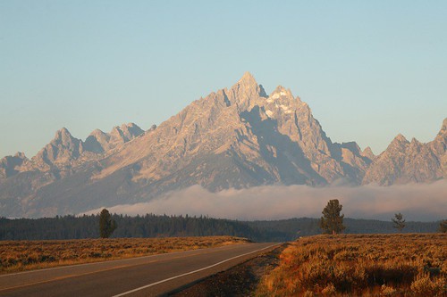
After climbing for a few days in the Cirque of the Towers, my cousin Lisa and I headed for the Grand Teton, which we planned on climbing before we headed back home. We had planned to climb the Direct Exum, but when we got there Lisa decided she did not want to climb the Grand Teton, so I headed up alone to solo the Upper Exum Route. I ran into a group of 3 climbers and teamed up with them, and had a blast.
I have posted photos and a complete trip report on my webpage:
http://sabegg.googlepages.com/grandteton
Enjoy!
-Steph
-
Trip: Cirque of the Towers, Wyoming - East Ridge of Wolf's Head and NE Face of Pingora
Date: 9/2/2007 - 9/5/2007
Trip Report:
At the end of the summer, my cousin Lisa and I headed south to climb in the Cirque of the Towers in the Wind River Range of Wyoming. This area has two climbs listed in Steck and Roper's Fifty Classics: the East Ridge of Wolf's Head and the NE Face of Pingora. These were stellar climbs on solid granite baked by the warm September sun. We had a blast.
I took lots of photos and posted a trip report on my webpage at:
http://sabegg.googlepages.com/cirquetowers2
Enjoy!
-Steph
-
I think I finally got the labelling right now....although in my Beckey guide Crooked Thumb and Ghost Peak are switched in one of the photos, so I'm not sure which is correct....
-
what you have labeled in your panorama as Himmelhorn is actually the Rake...Himmelhorn is over by Twin Needles..hence, the Ottohorn-Himmelhorn Col
Thanks Ross - did I get it right this time? Perhaps I'd know the peak names if I ever got as far as the Southern Pickets... =)
-
Yep, the Pickets are tough and commiting - just the kind of stuff I love to do! Just got to find someone of similar mind (and schedule). Next summer perhaps....
-
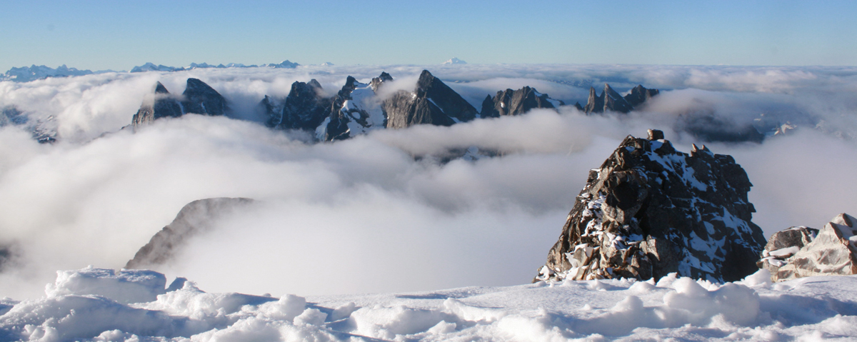
Trip: Pickets - Luna Peak and adventure in unnamed drainage just north of Access Creek -
Date: 8/21/2007 - 8/24/2007
Trip Report:
View from the summit of Luna Peak.
I just got back from my second attempt at a complete north to south Pickets traverse. Unfortunately, this attempt too did not go as planned, since my partner was getting quite beat up by the Pickets thus far and he decided he wanted to bail (NB. The Pickets really are as rugged as they say...).
The brief story of our trip is that we planned to ascend Access Creek but due to bad visability and bad assumptions and lack of map for the approach, we ended up ascending the unnamed drainage to the north of Access Creek. The bushwacking actually wasn't that bad, but when we got up to the ridge and the clouds cleared we realized our mistake, and had to spend half a day dropping down into the real Access Creek headwaters, where we camped. I climbed Luna the next day, before we headed out via Access Creek.
I have posted a trip report and photos here:
http://sabegg.googlepages.com/luna
-Steph
-
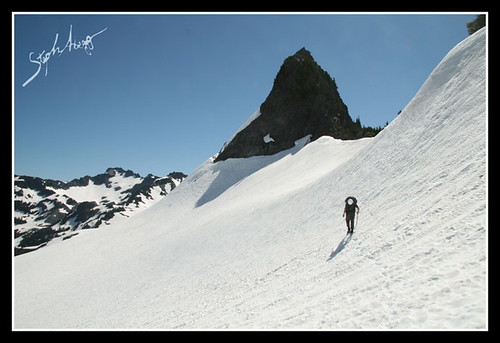
How about Luna, maybe taken by someone thrashing her way out Luna Creek?
You got the right peak!
.....But the wrong location. This photo was taken much higher than Luna Creek, on the NE ridge of Luna. Not a spot many have been, I would assume....I'll leave the story for my trip report, which will be posted shortly. We briefly considered trying to climb Luna from this side and dropping to the Luna-McMillan saddle, which might actually have been possible, but would have been pretty exposed and potentially loose terrain.
-
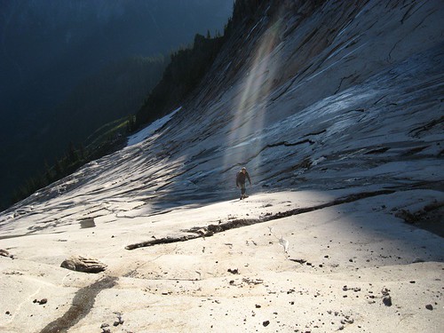
mixup?
good guess, but no. This peak is pretty well known, just not really from this angle....
30 years of change in the mountains
in Personal Climbing Web Pages
Posted · Edited by Steph_Abegg
http://sabegg.googlepages.com/comparisons
[img:center]http://farm4.static.flickr.com/3034/3021216484_dafc04245c_o.jpg[/img]